Sydney Area FAQ

Common questions that are asked in the Sydney Area:

How can I find out more information about Western Sydney Airport?

The flight paths and airspace design for Western Sydney International (Nancy-Bird Walton) Airport is being led by the Western Sydney Unit at the Department of Infrastructure, Transport, Regional Development and Communications. 

Further information on the airport and flight paths can be found on the Western Sydney Airport website.

Daytime harbour lane for helicopters and seaplanes

Sydney Harbour is a busy tourist precinct in the air as well as on the ground and there is growing demand for scenic flights. A harbour lane is available for the use of helicopters and seaplanes by day. This lane has been created so that harbour flights can occur without interfering with Sydney Airport arrivals and departures.

The lane follows the Parramatta River from Silverwater to Ryde Road Bridge, Gladesville Bridge, the southern pylon of the Harbour Bridge, past Bradley’s Head and Middle Head, Sydney Heads and then coastal to Long Reef.

Altitudes are restricted to a maximum of 500 feet at some points and 1,000 feet east of the Harbour Bridge. This is to ensure traffic in the lane remains outside controlled airspace. This means aircraft cannot fly higher without contacting air traffic control and receiving clearance to do so.

Wide view

The following image shows were most of these flights originate from and fly to reach the river.

Harbour lane

Close in

A closer view of the route over the river is shown below.

Harbour lane

Light aircraft coastal routes

Light aircraft routes extend along the coast line, both to the south and north of Sydney as follows

South Route

The southerly route extends between Jibbon Point and South Head. On this route an altitude of exactly 500 feet must be maintained to ensure there is no conflict with aircraft arriving and departing Sydney Airport.

Coastal route south

North Route

The northerly route extends east of the coast between the South Head of the Harbour and north to Dee Why. On this route aircraft must remain between 500 and 1,000 feet.

Coastal route north

Light aircraft and helicopter routes – west

All VFR routes
There are a number of routes around Sydney used by light aircraft and helicopters.

It is not mandatory that light aircraft and helicopters fly on these routes. As you will see from the images below which show the tracks of actual flights, some aircraft may fly the whole route but others may only fly part of it, joining or leaving it depending on their purpose or destination. Other aircraft may not use the routes at all.

These routes are mainly outside controlled airspace (“OCTA”), that is, aircraft are not being directed by air traffic control. Whenever they fly outside controlled airspace, pilots are following the rules of the air. Our booklet, Guide to our Operations, explains more about different types of airspace.

Pilots using these routes are usually flying under Visual Flight Rules, which means they navigate using landmarks that are easily seen from the air. This does not mean they must fly over each landmark; rather, they use each landmark to be sure of their position.

Most of these routes lead to and from Bankstown Airport, as shown in the images above and below.

Inbound from west

Light aircraft and helicopters inbound from the west to Bankstown Airport navigate using the Great Western Highway, Nepean Bridge, Western Motorway, Light Horse Interchange and Prospect Reservoir. Pilots will usually follow the Great Western Highway over the Blue Mountains to ensure they do not stray into the restricted military airspace around Richmond RAAF Base which is located immediately to the north.

Inbound from west

Outbound to west

When flying outbound to the west, aircraft must avoid the Richmond RAAF Base military area and will use the towns of Penrith, Glenbrook, Springwood and Katoomba as visual aids to avoid tracking into restricted airspace.

Aircraft may climb to 2,500 feet once they have passed the Liverpool to Parramatta railway line. Once west of Glenbrook aircraft may fly up to 6500 feet.

Outbound to west

Sydney Airport – Blue Mountains

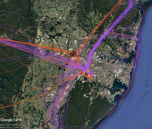
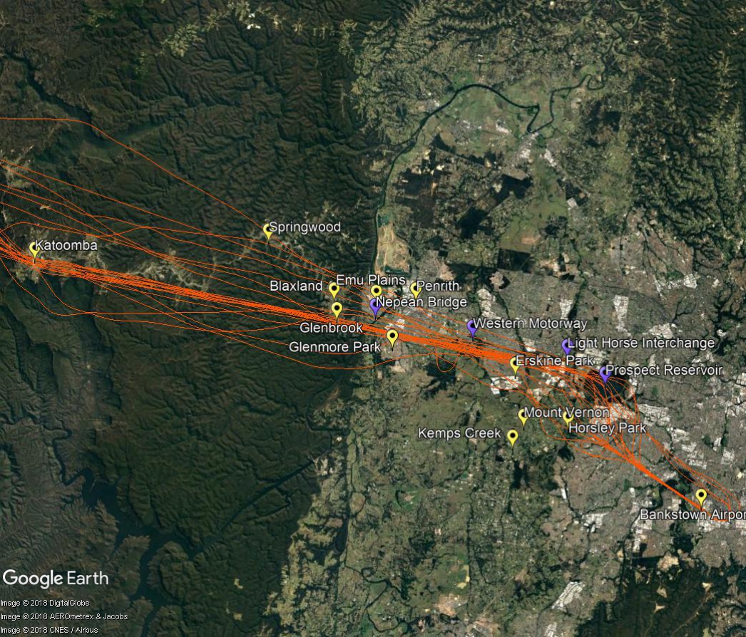
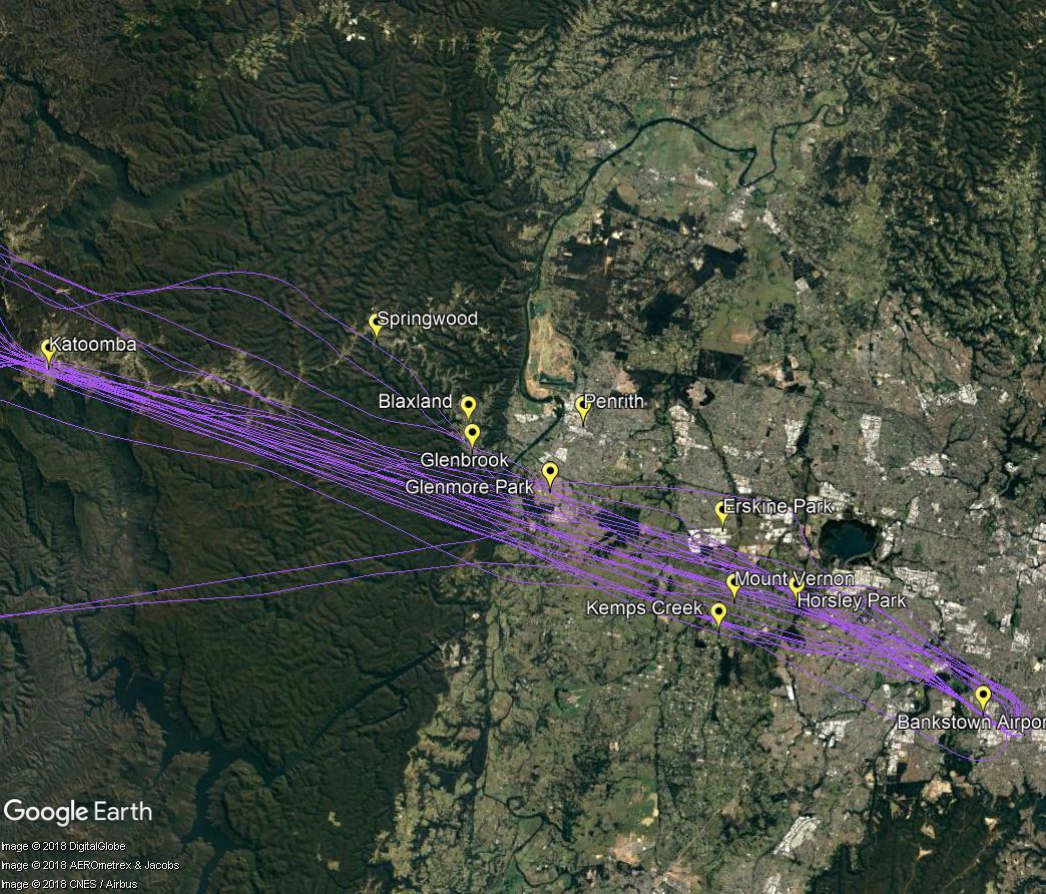
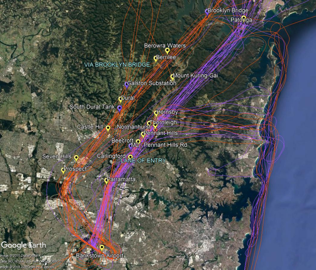
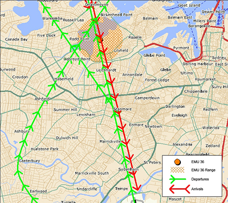
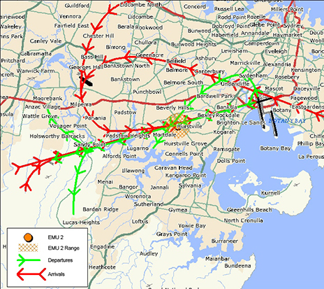
Aircraft that fly over the Blue Mountains from Sydney Airport depart from the westernmost of the parallel runways and turn towards the north-west. They are tracking towards a waypoint located over Katoomba. A waypoint is a set of co-ordinates in the air. This waypoint replaces a non-directional beacon which was a ground-based navigational aid that had been in this location since the 1950s.

Departure flight paths are organised so as to efficiently move aircraft onto their routes. The flight path that passes over the Blue Mountains is assigned to aircraft that are heading for destinations to the west, north and north-west such as Dubbo, Perth, Adelaide, Darwin, Broome, Singapore, Kuala Lumpur, Dubai, Abu Dhabi, Hong Kong and Shanghai, for example.

While this is not a new flight path, advances in navigation technology used by modern aircraft mean that aircraft are now able to fly flight paths more precisely and this has resulted in increased concentration of flight paths over the years, including this one.

Altitudes

The altitudes of traffic departing Sydney Airport will vary according to which runway the aircraft has departed from because this affects the number of track miles the aircraft has flown before it reaches the Blue Mountains. The more track miles flown, the more time the aircraft has had to increase altitude and the higher it will be over your area.

Altitudes will also vary according to other factors such as the weight of the aircraft and how heavily laden it is. For example, long-haul aircraft departing for Dubai will be much heavier than smaller aircraft heading to Perth or Adelaide due to fuel load and aircraft size and these differences in weight alone will affect an aircraft’s climb rate.

Even the atmospheric conditions at the time can play a part. When the weather is warm, the air is less dense and therefore there is less lift and the aircraft climbs more slowly. Due to these variable factors the altitudes quoted below are not limits and some aircraft may be higher and some lower that the ranges given.

Jet aircraft departing towards the north will generally be within the altitude range of 10,000 to 20,000 feet. Turbo-prop aircraft that have departed Sydney Airport may range from 7,000 to 15,000 feet.

For aircraft departing towards the south, jets will generally be from 15,000 to 25,000 feet. Turbo-prop aircraft will usually be from 10,000 to 15,000 feet.

Many Blue Mountains residents have told us they feel jet aircraft are lower now than in the past. We conducted an investigation into this question, looking at altitudes of aircraft that passed within a five kilometre radius of Blaxland in January of each year from 2012 to 2018. The investigation found variation in altitudes between different aircraft types but relatively little variation within the same aircraft type. The variation in altitudes between aircraft types can be attributed largely to the differing maximum take-off weight of each type. Heavier jets demonstrated a poorer climb performance than lighter jets.

The investigation also found a marked increase in airlines using A380-800 aircraft – from 23 flights in January 2012 to 126 flights in January 2018. As the A380 is the heaviest jet and as the study indicated that they have the lowest average altitude, the increased use of this aircraft type is likely to be a major contributing factor to the community’s perception that altitudes over Blaxland have decreased.

Prospects for change

Airservices has investigated whether it would be feasible to move the Katoomba waypoint. The investigation found that this would adversely impact on safety and would not be operationally feasible due to the constraints of military airspace restrictions and air traffic control sector boundary and route segregation requirements. It would also negatively impact on communities closer to Sydney Airport where the noise levels would be higher than those currently experienced in the Blue Mountains.

Light aircraft and helicopter routes – north

All VFR routes
There are a number of routes around Sydney used by light aircraft and helicopters.

It is not mandatory that light aircraft and helicopters fly on these routes. As you will see from the images below which show the tracks of actual flights, some aircraft may fly the whole route but others may only fly part of it, joining or leaving it depending on their purpose or destination. Other aircraft may not use the routes at all.

These routes are mainly outside controlled airspace (“OCTA”), that is, aircraft are not being directed by air traffic control. Whenever they fly outside controlled airspace, pilots are following the rules of the air. Our booklet, Guide to our Operations, explains more about different types of airspace.

Pilots using these routes are usually flying under Visual Flight Rules, which means they navigate using landmarks that are easily seen from the air. This does not mean they must fly over each landmark; rather, they use each landmark to be sure of their position.

Most of these routes lead to and from Bankstown Airport, as shown in the images above and below.

To and from the north

The two northern routes are shown in the image below. One is via Brooklyn Bridge, the Galston electricity substation, the water tank at South Dural and Prospect Reservoir.

The other route is a designated “lane of entry” that allows aircraft to come and go from Bankstown Airport without entering the controlled airspace of Sydney Airport or Richmond RAAF Base. It is also used by aircraft transiting from north of Sydney to areas south and south west of the city. This corridor of airspace has a ceiling height of 2,000 to 2,500 feet.

The lane of entry runs between Bankstown Airport and Patonga. Outbound aircraft head to Parramatta and past the Prospect to Potts Hill pipeline. Once north of the pipeline aircraft can climb to 2,000 feet. Tracking features include the intersection of the M2 and Pennant Hills Road, the strobe light at Pennant Hills CBD, a covered reservoir at Thornleigh and the Hornsby CBD and railway sheds. The track then follows the eastern side of the M1 motorway (Sydney Newcastle Freeway) and onwards to Patonga.

Aircraft may turn east from the lane at Hornsby and travel towards the coast using the Baha’i Temple as a tracking feature. Once at the coast aircraft may track to Long Reef or conduct a harbour scenic flight or coastal flight.

In the image below the tracks of inbound aircraft are shown in orange and outbound are purple.

Inbound from north

The Sydney Noise and Flight Path Monitoring System (NFPMS)

We collect noise and operational data from twelve noise monitors (Environmental Monitoring Unit, EMU) around Sydney Airport. Noise monitors are listed below according to their location.

Access monthly data on our Sydney noise monitoring reports page.

Northern Monitors

Sydenham and St Peters

EMU 6 (Sydenham)

Sydenham (EMU 6)

Captures arrivals to Runway 16 Right and departures off Runway 34 Left. This monitor is closest to the threshold of Runway 16 Right/34 Left. The consistently high number of noise events reflects the high use of the main runway throughout the year.

EMU 13 (St Peters)

St Peters (EMU 13)

Main purpose is to capture arrivals to Runway 16 Left, however it can capture movements from Runway 16 Right/34 Left and departures off Runway 34 Right.

This monitor captures many of the same operations as the Annandale monitor and demonstrates the same seasonal pattern. However, being closer to the runway it captures more aircraft noise events.

EMU 12 (Annandale)

Annandale (EMU 12)

Main purpose is to capture arrivals to Runway 16 Left, however it can also capture movements from Runway 16 Right/34 Left and departures off Runway 34 Right.

The pattern of aircraft noise events recorded at this monitor reflects the seasonal pattern use of Runway 16 Right, with generally more events recorded in summer than in winter.

EMU 36 (Leichhardt)

Leichhardt (EMU 36)

Captures arrivals to Runway 16 Right.

This monitor is affected by the same operations as Hunters Hill monitor and reflects the seasonal pattern use of Runway 16 Right, with more events captured in summer than in winter.

EMU 116 (Hunters Hill)

Hunters Hill (EMU 116)

Captures arrivals to Runway 16 Right.

The number of noise events recorded by this monitor reflects the seasonal pattern use of Runway 16 Right, with more events captured in summer than in winter.

EMU 102 (Croydon)

Croydon (EMU 102)

Captures departures off Runway 34 Left.

The number of noise events recorded reflects the seasonal pattern use of Runway 34 Left with more aircraft noise events captured in winter than in summer.

Southern Monitors

EMU 1 (Threshold Runway 34)

Threshold Runway 34 (EMU 1)

Captures departures off Runways 16 Right and 16 Left and arrivals to Runways 34 Left and 34 Right

The number of aircraft noise events captured reflects the pattern of use of Runway 34 Left, with more events generally recorded in winter than in summer.

EMU 101 (Kurnell)

Kurnell (EMU 101)

Captures arrivals to Runway 34 Right and some arrivals to Runway 34 Left

Eastern Monitors

EMU 99 (Eastlakes)

Eastlakes (EMU 99)

Captures arrivals to Runway 25 and departures off Runway 07 and Runway 34 Right.

The pattern of aircraft noise events recorded reflects the seasonal use of Runway 34 Right, with more movements in winter than in summer.

EMU 100 (Coogee)

Coogee (EMU 100)

Captures arrivals to Runway 25, departures off Runway 07 and Runway 34R heading to the east and south.

Captures noise from similar operations and reflects the same seasonal pattern to the Eastlakes monitor, however being further east from the airport the number of noise events recorded is smaller.

Western Monitors

EMU 3 (Bexley)

Bexley (EMU 3)

Captures arrivals to Runway 07 and departures off Runway 25.

This monitor is closer to the runway than the Penshurst monitor, therefore it displays the same trends but records more aircraft noise events.

EMU 2 Penshurst

Penshurst (EMU 2)

Captures arrivals to Runway 07 and departures off Runway 25.

Historically at Sydney Airport there are fewer departures off Runway 25 than the other Runways.


Learn more about monitoring aircraft noise on the Airservices website.

Sydney Airport Australian Noise Exposure Index (ANEI)

We are responsible for developing Australian Noise Exposure Index (ANEI) contours for Sydney Airport. ANEI contours are based on historical data and show the average daily aircraft noise exposure over the specified period.

The ANEIs for 1 January 2018 to 31 December 2025 are shown below.

Earlier ANEI Reports

Previous reports are available on request.

Technical Information

The ANEI contours were generated using United States Federal Aviation Administration (US FAA) Airport Environmental Design Tool (AEDT)

The following key inputs were used to develop the AEDT model:

  • the default Sydney Airport layout was used in AEDT, which contained data for runway ends and thresholds – the helipad location was manually added at – 33.94 latitude, 151.19 longitude and elevation of 20 feet
  • aircraft movement data and radar flight tracks for the year were input from our Noise and Flight Path Monitoring System (NFPMS)
  • standard arrival and departure profiles were used
  • aircraft vertical profiles (i.e. stage lengths) were based on the distance travelled to or from each origin destination
  • where possible, the correct aircraft types in AEDT were used to represent actual aircraft movements – some aircraft types that do not exist in AEDT version 2d were substituted based on similar size and weight
  • default meteorological conditions in AEDT were used
  • terrain information was incorporated into the model.

Archived Sydney Airport Operational Statistics Reports


Reports and statistics for earlier periods are available by request through the online portal on the Airservices website. A fee may apply.

Sydney Airport curfew rules

Airport curfew

An airport curfew is a legislated restriction on aircraft operations at a federally-leased airport during a specified time period.

A curfew limits the types of aircraft that are permitted to use Sydney Airport between 11.00pm and 6.00am each day.

While most aircraft operations are prohibited during this period, emergency aircraft, some small jets, propeller-driven aircraft and freight movements are allowed, and, in exceptional circumstances, other aircraft that have been granted a dispensation to land by the Minister. The curfew limits what aircraft can land and take-off and, in some cases, the runways that can be used.

An aircraft may take off after the start of curfew if it received taxi clearance before the curfew began. Under the curfew regulations, a limited number of passenger flights may be permitted to land between 5.00am and 6.00am during non-daylight-saving periods. These flights arrive after the curfew ends at 6.00am when daylight saving is in place, but arrive an hour earlier when clocks are turned back at the end of daylight saving. These flights generally originate from ports where curfews prevent them leaving later.

During the curfew aircraft must take off and land over Botany Bay.  The only exception to this is for emergency services. When an aircraft landing at or taking off from Sydney Airport flies over residential suburbs during the curfew it is usually the Royal Flying Doctor Service or another emergency medical flight.  This is because these flights are always given the most direct route between the airport and the emergency due to the nature of their missions. You can use WebTrak to identify these flights by their flight number which will begin with:

  • AM (NSW Air Amubulance),
  • FD (Royal Flying Doctor Service) or
  • RSCU (NSW Rescue Helicopter).

This curfew applies only to movements that originate from, or end at, Sydney Airport.  This means that an aircraft may travel over Sydney during the curfew if it is coming and going from destinations other than Sydney Airport such as, for example, Bankstown or Camden Airports or other aerodromes or helipads.

Curfews are legally enforceable and regulated by the Department of Infrastructure, Transport, Regional Development and Communications,  who can make a determination of a curfew violation and prosecute an airline or aircraft operator for breaching a curfew.