Learn about flight paths and aircraft movements in your area
Welcome to the Aircraft in Your Neighborhood Portal
Our goal is that you will learn more about the flight paths and aircraft movements in your area and be able to access the information and resources that explain how air traffic is managed.
First, please select your location using one of the following options, so that we can customize the information for your location.
We’ll remember your location so you don’t have to enter it every time you visit the site and we’ll keep this information confidential.
Please note, that this site works best on Chrome, Firefox and Edge.
* Mandatory - Select region first to view the map.
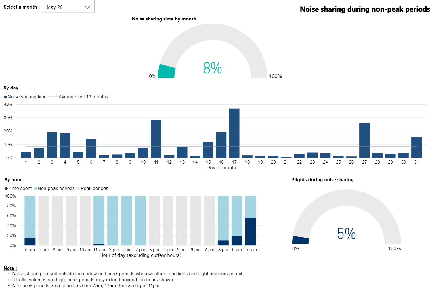
LTOP Statistics provide information on noise sharing for Sydney Airport. Further NAP reporting is under development to compliment this information and will be available in 2026.
It is important to note that NAPs are not mandatory; ATC and pilots apply the NAPs whenever possible. Pilots and ATC will determine when critical operational requirements override the use of NAPs.
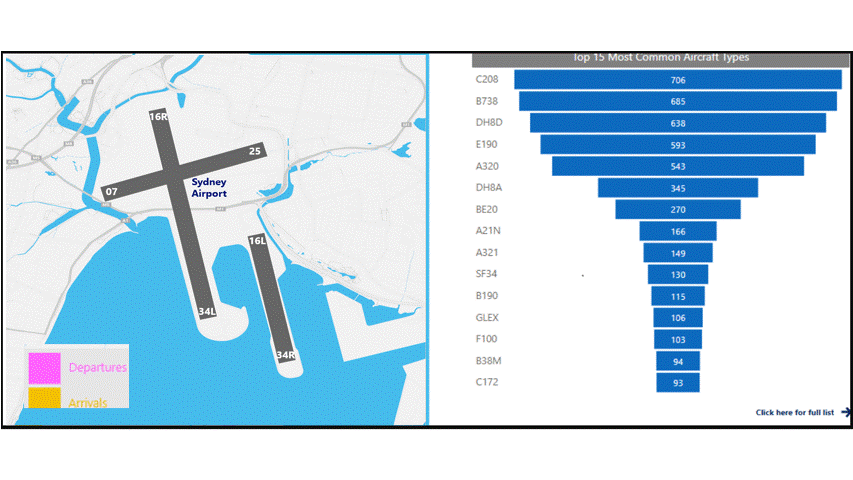
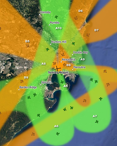
The overview below provides monthly movement numbers, runway end usage, and the types of aircraft operating at Sydney airport.
Note: Due to rounding, percentage values may not sum to exactly 100.0%. Minor discrepancies of up to ±1% are expected and do not indicate any errors in the underlying absolute figures, which remain accurate and unaffected.
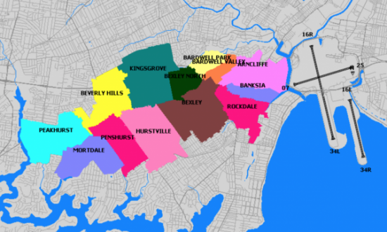
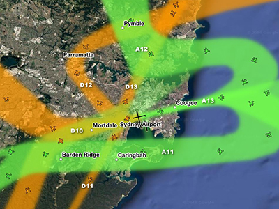
Suburbs to the immediate west of Sydney Airport are affected by aircraft arriving to (“east flow”) and departing from (“west flow”) the east-west runway.
Below: east flow (left) and west flow (right)
Sydney’s seasonal wind patterns mean that you are more likely to experience arrivals in the warmer months and departures in the cooler months. This is because aircraft need to take off and land into the wind. You are also more likely to experience traffic in non-peak periods when the east-west runway is used whenever possible for noise sharing purposes. Non-peak periods are generally:
6:00 – 7:00am,
11:00 – 3:00pm, and
after 8:00pm.
These times may vary, however. There will also be days when the wind conditions make use of the two north-south parallel runways impossible, and on such days you are likely to experience heavy levels of traffic for prolonged periods.
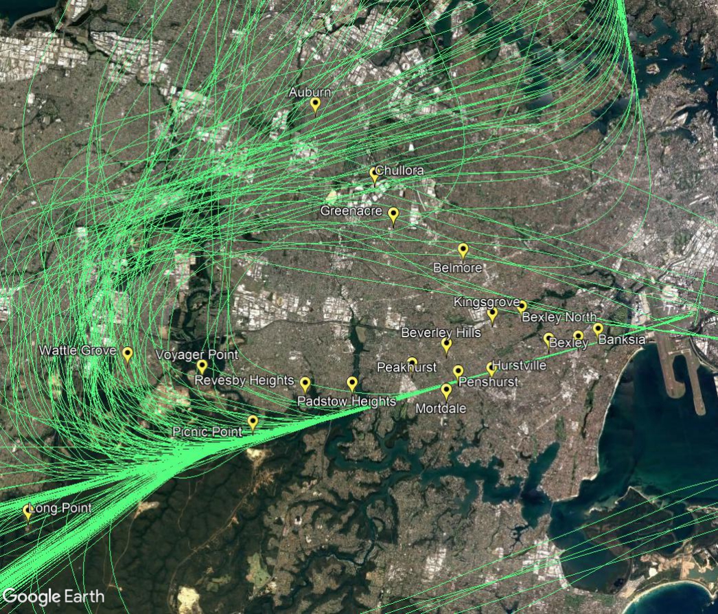
Arrivals – east flow
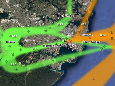
Arriving aircraft must align with the runway from a considerable distance out from the airport, and fly straight in. This means that aircraft arriving to land on the east-west runway will always fly over suburbs such as Picnic Point, Penshurst, Hurstville, Bexley and Rockdale. The following image shows actual tracks of arriving aircraft.
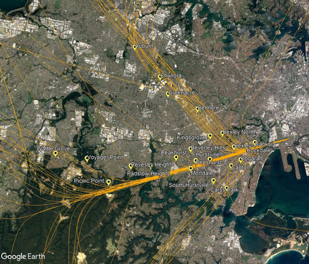
Departures – west flow
Aircraft departing towards the west will turn to their heading when they reach 1,500 feet (for jets) or 800 feet (for non-jets). As different types of aircraft have different climbing abilities, they will reach this altitude at different points after take-off and therefore begin their turns at different points in the air. This has the effect of creating a spread of aircraft as can be seen in the image below.
If the aircraft is proceeding to destinations to the west such as Perth or south such as Melbourne it will maintain the runway heading for longer before turning.The following image shows actual tracks of departing aircraft.
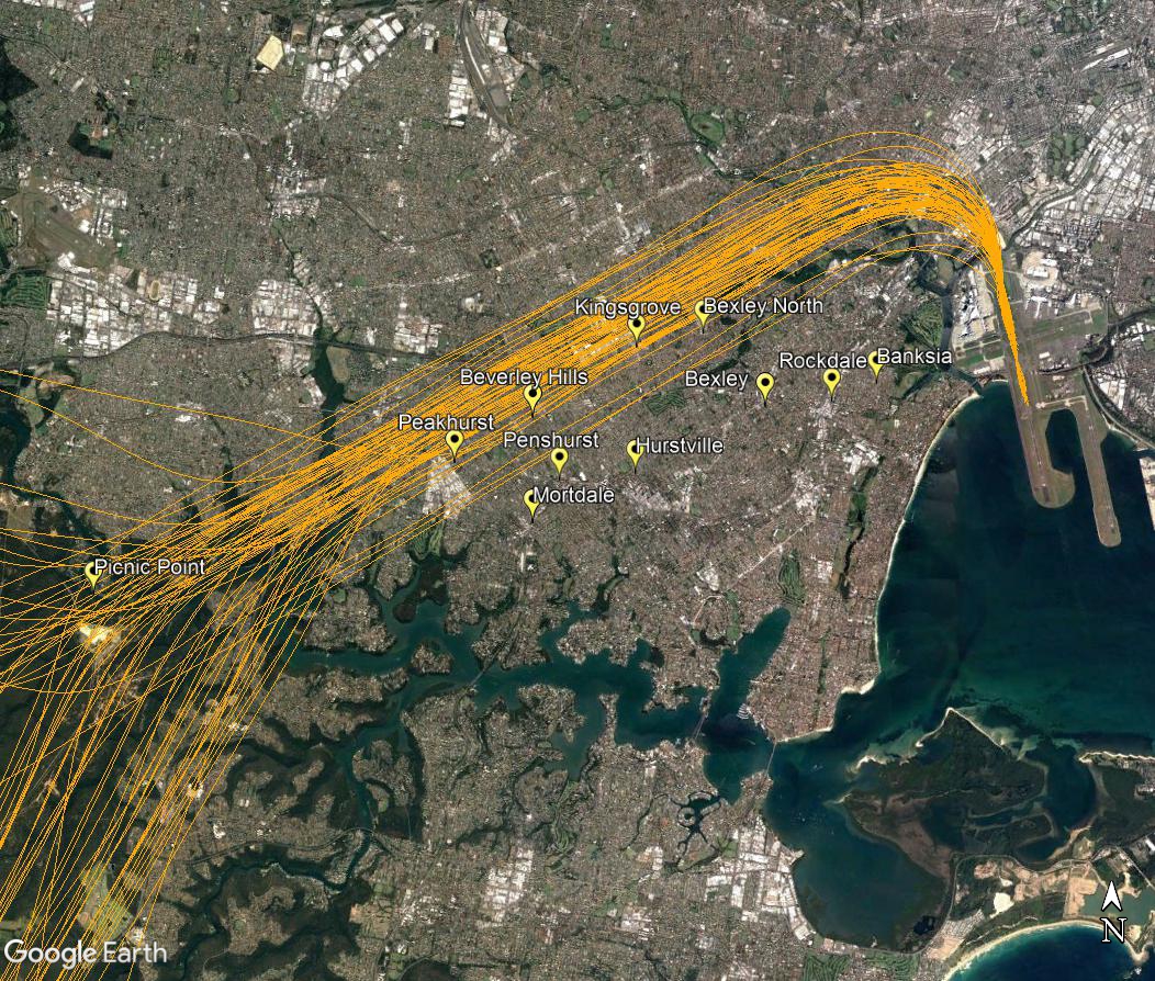
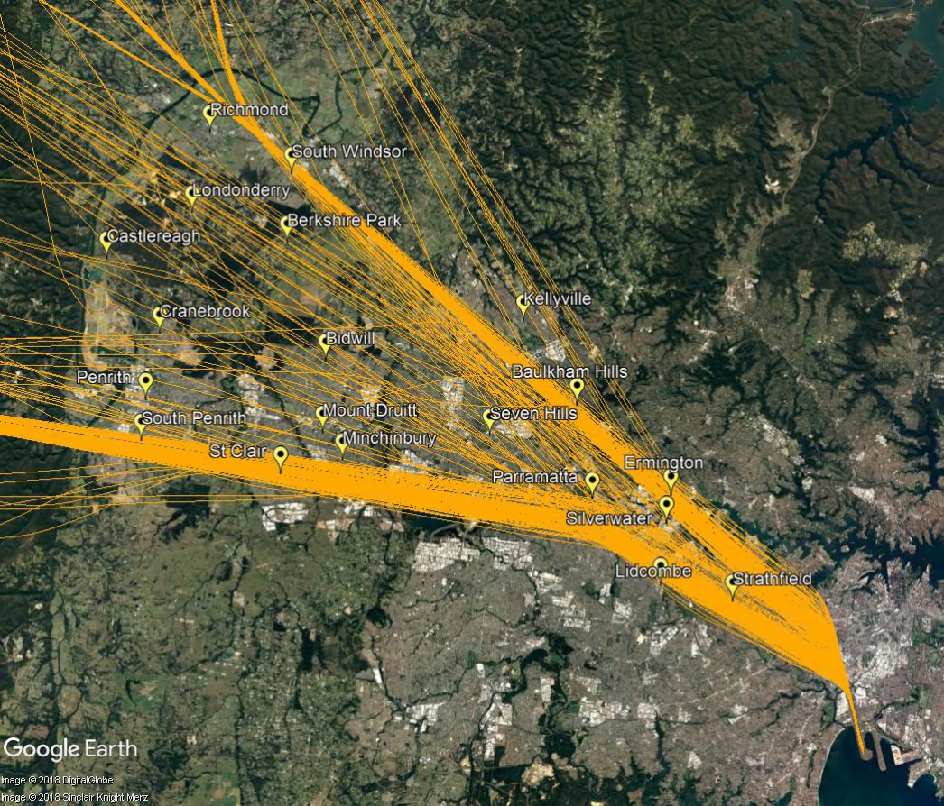
Departures – north flow
When aircraft are departing from the westernmost of the parallel runways, non-jets (turbo-prop aircraft) that are heading for southerly or westerly destinations will turn left after departure when they reach the altitude of 600 feet. This will create a spread of aircraft, taking them over suburbs such as Kingsgrove, Beverley Hills and Peakhurst. This is illustrated in the track image below.
Jet and turbo-prop aircraft that are heading for destinations to the west, north and north-west will fly over or near your area after departure from Sydney Airport. This corridor is labelled D5 in the image, right. These flights are bound for destinations such as Dubbo, Perth, Adelaide, Darwin, Broome, Singapore, Kuala Lumpur, Dubai, Abu Dhabi, Hong Kong and Shanghai.
As shown in the image below of actual tracks of departing aircraft, there are two concentrated flight paths. One tracks towards Richmond, passing over suburbs such as Ermington, Baulkham Hills and South Windsor. The other tracks towards Katoomba over Parramatta, St Clair and South Penrith.
Aircraft will also fly on either side of these two flight paths. This traffic is being individually directed by air traffic control in order to manage the volume of aircraft in the airspace. For example, a slower aircraft may be moved off the main flight path in order to take it out of the way of a faster jet behind it.
Altitudes over your area will vary according to factors such as the weight of the aircraft and how heavily laden it is. For example, long-haul aircraft departing for Dubai will be much heavier than smaller aircraft heading to Perth or Adelaide due to fuel load and aircraft size and therefore they will climb more slowly. The maximum take-off weight (MTOW) for an Airbus A380 is 560,000kg and for a Boeing B747 it is 396,890kg. The MTOW of an A320 is 73,500kg and for an A330 it is 230,000kg.
While differences in weight will affect an aircraft’s climb rate, even the atmospheric conditions at the time can play a part in how quickly an aircraft can climb. When the weather is warm, the air is less dense and therefore there is less lift and the aircraft climbs more slowly.
Generally, the average altitude of an A380 over Parramatta is around 5,500 feet and over South Penrith around 9,000 feet. In contrast the average for the smaller A320 or B737 over Parramatta is around 6500 feet and over South Penrith around 14,000 feet.
Over Baulkham Hills an A380’s average altitude is around 7000 feet and over Richmond around 11,500 feet. An A320/B737 would be at an average of around 8,500 feet over Baulkham Hills and 15,000 feet over Richmond.
This image shows the tracks of departing aircraft:
Federally-leased airports (excluding Mt. Isa and Tennant Creek) have established Community Aviation Consultation Groups (CACGs), which provide an effective avenue for local community engagement on airport planning and operations, including aircraft noise. The Department for Infrastructure, Transport, Regional Development and Communications provides guidelines for CACGs.
Non federally-leased airports may also choose to establish CACGs or community forums.
CACG membership depends on the characteristics of the airport and any local issues of community concern however, generally includes:
airport management
aircraft operators
community organisations or representatives
representatives from state, territory or local government bodies
local tourism and business groups.
Airservices does not formally belong to CACGs, but is invited to attend to provide relevant information and assist in discussions. We engage with CACGs on flight path and airspace changes, as well as technical reviews, such as noise monitoring and noise abatement procedures.
In 2013, we developed a trial departure procedure to minimise the noise impact on La Perouse and the Kurnell Peninsula.
The procedure was tested using flight simulators. While normal or low weight operations were able to fly the procedure, in certain weather conditions, heavy aircraft flew over the tip of the Kurnell Peninsula.
Overall, the trial procedure delivered no better outcome than the current design, so was not progressed.
During the curfew (11pm to 6am) aircraft that are permitted to operate must depart towards the south over the water from Runway 16R (the western most of the parallel runways). The flight path used during the curfew is closer to the coast than the flight path used during the day.
The Aircraft Noise Ombudsman asked us to investigate whether it was feasible to move the curfew flight path further away from the coast. We found this was feasible but a more practical solution was to make the daytime jet departure path available for the non-jet aircraft that fly during curfew.
This would improve noise impacts during the curfew by moving aircraft further east of Cronulla, Bundeena and nearby areas.
The change was implemented from 9 November 2017.
Further information about the change can be found on the Airservices website.
There are helicopter routes between Sydney Airport, the harbour and the coast. Scenic helicopter flights in these areas are becoming increasingly popular, especially on weekends and holidays.
Helicopters will fly these routes in one of two ways outline below. Helicopters may fly outside these routes if (for example):
they are bound for other destinations, or
by direction of air traffic control, or
if they are conducting “airwork” such as aerial filming, photography or surveying, shark spotting, or
if they are performing emergency services operations.
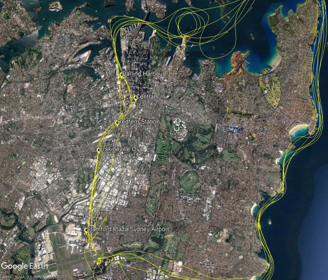
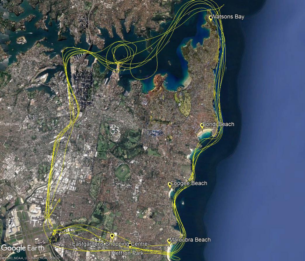
Option 1: To/from the north
Helicopters inbound to Sydney Airport from the north will track from Darling Harbour to Central Railway station, usually at 1000 feet. Altitudes may vary on instruction by air traffic control. They will then follow the railway line to Redfern Station. From there they track to Erskineville Oval before descending to 500 feet while tracking to The Stamford Hotel on the outskirts of the airport. Instructions are then given for tracking to the helipad.
Outbound helicopters track via The Stamford to Erskineville Oval and then via Redfern Railway Station and the railway line to Central, and then to Darling Harbour, all at 1,000 feet.
Option 2: To/from the West
Helicopters inbound to Sydney Airport from the west will track from Maroubra Beach to Heffron Park on Bunnerong Road and to Eastgardens Shopping Centre at 1,000 feet. From there they towards Southern Cross Drive while descending to 500 feet (altitudes may vary on instruction by air traffic control). They are then given instructions by air traffic control for tracking to the helipad.
Outbound helicopters track via Southern Cross Drive to Eastgardens Shopping Centre at 1,000 feet and then to Maroubra Beach. Once east of the coast they will descend to 500 feet which is the minimum altitude for flight over water.
We conducted a an investigation into whether it was feasible to alter the flight path over Katoomba (Blue Mountains), including what impact this would have on other routes.
Our investigation found this would adversely impact on safety and would not be operationally feasible due to the constraints of military airspace restrictions and air traffic control sector boundary and route segregation requirements.
We also found a change would negatively impact on communities closer to Sydney Airport.
A further investigation was conducted in 2017 for a noise improvement suggestion from the Aircraft Noise Ombudsman. This investigation found that the change would significantly increase complexity, did not meet accepted design standards and could have a negative impact on parts of the community closer to the airport.
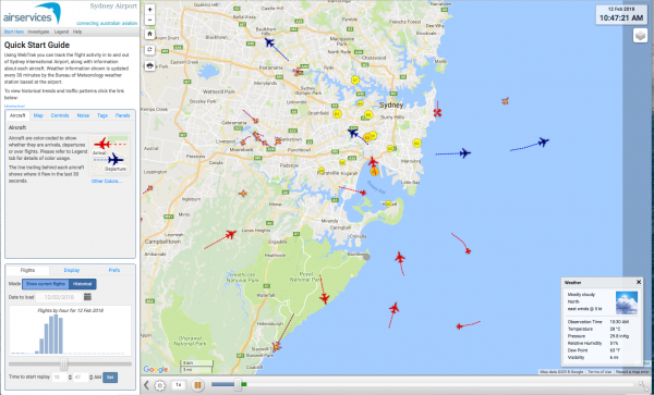
WebTrak is a tool that enables the community to see where aircraft fly and explore historical trends and patterns. WebTrak is provided by Envirosuite.
WebTrak uses information from air traffic control radars to display aircraft movements. The flight search and display function allows you to view aircraft flight activity over metropolitan areas. You can also:
locate your street address and have your home appear on the map
see noise levels of individual aircraft
view information about aircraft type, height, origin and destination
display an aircraft’s flight path and point of closest approach to your home
zoom in and out down to street level.
Note that there is a slight delay on the display of flights.