Learn about flight paths and aircraft movements in your area
Welcome to the Aircraft in Your Neighborhood Portal
Our goal is that you will learn more about the flight paths and aircraft movements in your area and be able to access the information and resources that explain how air traffic is managed.
First, please select your location using one of the following options, so that we can customize the information for your location.
We’ll remember your location so you don’t have to enter it every time you visit the site and we’ll keep this information confidential.
Please note, that this site works best on Chrome, Firefox and Edge.
* Mandatory - Select region first to view the map.
(1.a) Arrivals: Expect processing via published STAR.
Departures
(1.b) Departures: Expect processing via published SID.
Adherence with this procedure is reported below.SID operations are reported up to 10,000ft adherence.
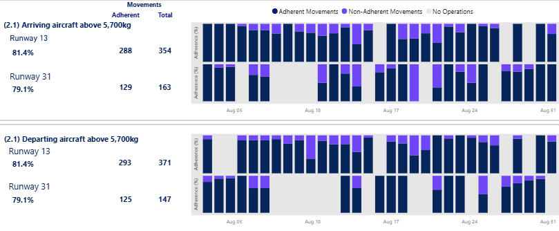
2. Arriving Aircraft During Approach Hours of Operation
2.a: Arriving Runway 12: No specific procedures apply.
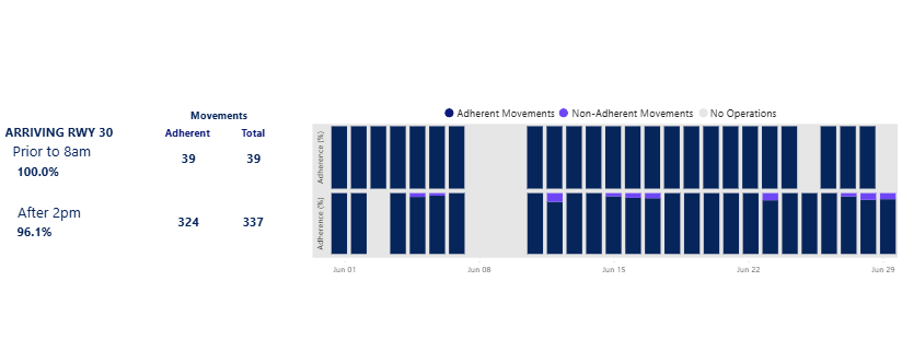
2.b: Arriving Runway 30:
Before 08:00 – Aircraft will use the RNAV approach.
From 08:00 to 14:00 – No special procedures apply.
After 14:00 – Aircraft will again use the RNAV approach.
2.c: Departing Runway 12 and 30: Refer to 1.b.
2.d: Arrivals VOR approaches – currently specific VOR approach data is not available.
Adherence with the 2.b procedure is reported below.
3. Arriving Aircraft Outside Approach Hours of Operation
3.a: Arriving Runway 12: No specific procedures apply.
3.b: Arriving Runway 30: Refer to 2.b.
3.c: Departing Runway 12 and 30: No specific procedures apply.
3.d: Arrivals VOR approaches – currently specific VOR approach data is not available.
Standard Instrument Departures (SID) and Standard Instrument Arrivals (STARs) are published flight paths designed to enhance safety, efficiency, and predictability. Air traffic control (ATC) may issue a deviation to a SID or STAR due to weather and/ or traffic conditions.
The report is best viewed in full screen mode.
Note: Due to rounding, percentage values may not sum to exactly 100.0%. Minor discrepancies of up to ±1% are expected and do not indicate any errors in the underlying absolute figures, which remain accurate and unaffected.
Aircraft will be routed away from populated areas until they are either over the ocean, or lined up with their final approach path – reporting options currently under review.
Pilots should delay using flaps as long as safely possible to reduce noise during landing – data not available.
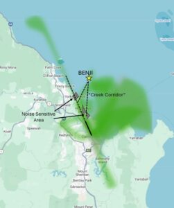
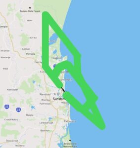
2.1.a: Arrivals to Runway 15
When weather is good (VMC), aircraft will:
Follow STAR procedures (Standard Arrival Routes).
May be directed to do a Runway 33 LOC approach.
May also visually manoeuvre from BENJI waypoint to cross the coast at Richter’s Creek.
2.1.b: Arrivals to Runway 33
Track via LOC approach or
If suitable weather join a visual right circuit seaward of the coastline.
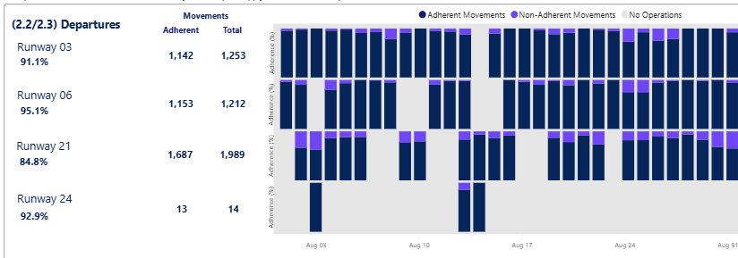
2.2: Departures
Aircraft to follow SID procedures and then be routed clear of populous areas.
The Preferred Flight Paths Report below shows a low adherence of departures from Runway 33 following the preferred flight paths. This means that aircraft that are departing the runway towards the north are not following the preferred departure flight path.
Our investigation of this low adherence shows that while departing aircraft are following the departure path over land, many of the aircraft that are headed to southern destinations will turn right and cross the coastline, after which point they often deviate from the departure flight path when over water, due to air traffic operational requirements.
Noise abatement focuses on methods to minimise aircraft impacts over land. As this deviation from the departure flight path is occurring over open water, the operation remains consistent with the intent of the preferred flight paths NAP, being to avoid populous areas.
We are working to modify the collation and reporting of this data to better reflect the on-ground experience of noise abatement.
Note: Air Traffic Control may adjust paths for weather and/or traffic conditions.
Standard Instrument Departures (SID) and Standard Instrument Arrivals (STARs) are published flight paths designed to enhance safety, efficiency, and predictability. Air traffic control (ATC) may issue a deviation to a SID or STAR due to weather and/ or traffic conditions.
The report below provides the percentage adherence against the NAP criteria for preferred flight paths from June 2025. Reporting dating back to January 2025 is currently being prepared and will be added to this page soon.
The report is best viewed in full screen mode.
Note: Due to rounding, percentage values may not sum to exactly 100.0%. Minor discrepancies of up to ±1% are expected and do not indicate any errors in the underlying absolute figures, which remain accurate and unaffected.
Turbo-prop aircraft – minimum altitude of 3,000 ft AGL.
Jet aircraft – minimum altitude of 5,000 ft AGL.
Note: Unless specified otherwise (see Clause 2.2), air traffic control apply these minimum heights for noise abatement purposes.
This NAP is under review to determine how it can be reported
2.2 Departures to the east of Perth
Aircraft departing to the east of Perth on SIDs will be kept on track until leaving an altitude of 8,000ft except when required for operational reasons
*A SID is a published route aircraft use to safely travel through the busy airspace surrounding airports. Aircraft follow this route from departure to where they transition to the enroute (high-level airspace) phase of their flight. Procedural SIDs act like a road, providing an established path for aircraft to track along. They make separation from other aircraft easier and air traffic control more predictable.
Adherence with this procedure is reported below (combined with 2.3).
2.3 Departures
Air traffic control (ATC) shall normally process departing aircraft using standard departure paths (SIDs)
When not following a procedural SID, use flight paths that approximate the SID tracks where possible
Notes for 2.2 and 2.3:
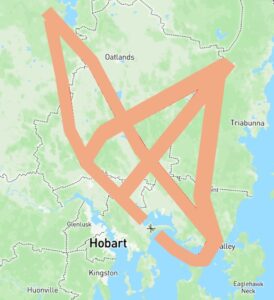
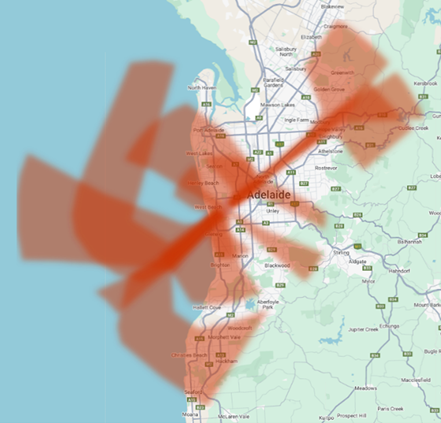
Adherence with SID procedures 2.2 and 2.3 combined is shown in the graphs below, reported up to 10,000ft adherence. Lower adherence rates are typically due to aircraft being taken off a SID to track a more direct route to their destination, once above 5,000ft (in line with minimum heights in Clause 2.1).
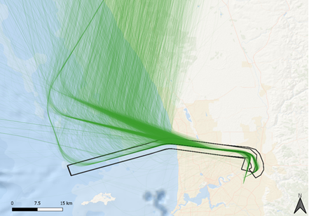
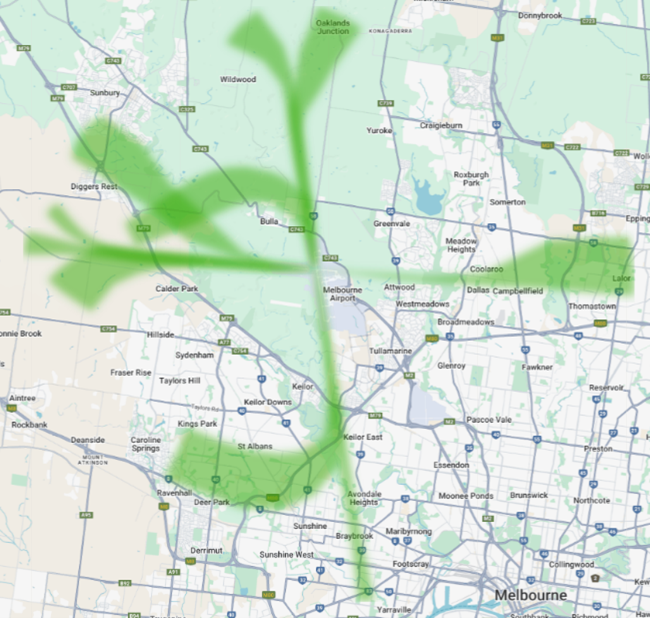
Due to the close proximity of Air Force Base Pearce military airspace to the north, Perth Airport SIDs are designed to take civilian aircraft around/ above the military airspace when it is active. When Pearce airspace is not in use, it is common practice for civilian aircraft to fly a more direct route to the north. The image to the right shows a SID route over water in black used when Pearce military airspace is active, and a sample of actual aircraft departure tracks from 2025 in green, taking a more direct route when Pearce airspace is not in use). To learn more about the Pearce airspace, click here.
2.4 Arrivals
Arriving aircraft must be processed via standard arrival paths (STARs)* where available
Only deviate from STAR path if essential for sequencing arrivals or separation with other aircraft
*A STAR is a published arrival route aircraft use to safely travel through the busy airspace surrounding airports. STARs help organise the flow of arriving air traffic and ensure aircraft arrive in a safe and orderly manner.
STARs are connected to the airport runway by various approach procedures, which are selected based on aircraft technology and weather conditions.
Adherence with this procedure is reported below
Notes:
Adherence is reported up to 10,000ft. Lower adherence results are typically due to aircraft being guided off the STAR path when at higher altitudes above 5,000ft (in line with minimum heights in Clause 2.1).
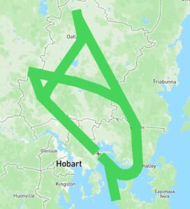
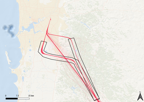
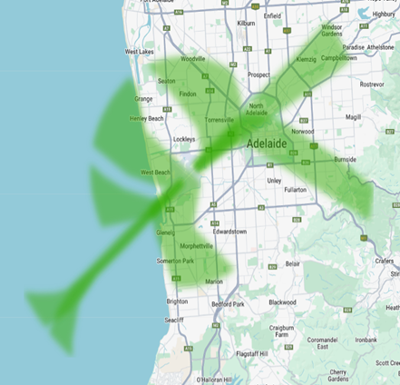
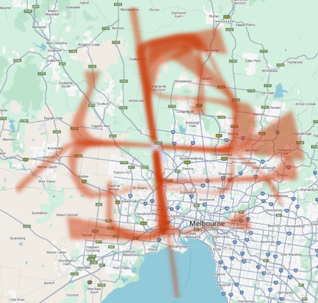
Air traffic controllers can sometimes guide a plane off the STAR path and give it a more direct route prior to joining the final runway-aligned landing path. Controllers do this to keep safe spacing between planes, manage traffic flow, and make the landing process more efficient. The image to the right shows an example of arrivals to Perth Airport from the south – STAR routes are in black, with a sample of actual aircraft arrival tracks from 2025 in red. The middle straight red line shows aircraft taken off the STAR path for a more direct route.
2.5 Non-STAR Tracking
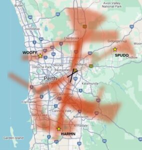
Non-STAR tracking must approximate STAR tracks or comply with minimum height requirements, with specific exceptions for each landing runway direction (e.g. visual approaches where pilots navigate by visual landmarks instead of procedures, and other exceptions based on the direction of arrival). These exceptions are:
Landing runway 21, arriving from the south
Aircraft at or below 45000kg maximum take-off weight can fly visually using a left turn to join final approach
Landing runway 21, arriving from the west
via waypoint WOOFY to 6 nautical miles from Runway 21 for a visual approach
Landing runway 24, arriving from the south
via waypoint SPUDO
Landing runway 03, arriving from the south or west
via waypoint HARMN for an Instrument Landing System (ILS) approach
track to 5 nautical miles from Runway 03 for visual approach
Landing runway 06, arriving from the southwest or west
track west of the coast to conduct a straight in approach
Waypoints – A waypoint is a geographical location used to define a point on a flight path. Waypoints are defined by geographic coordinates and typically take the form of a five-letter capitalised word e.g. WOOFY, SPUDO, HARMN.
Standard Instrument Departures (SID) and Standard Instrument Arrivals (STARs) are published flight paths designed to enhance safety, efficiency, and predictability. Air traffic control (ATC) may issue a deviation to a SID or STAR due to weather and/ or traffic conditions.
Due to a technical issue, the January 2026 reporting figures for Clause 2.5 initially captured only STAR‑adherent movements. This issue was corrected on 2 April 2026, and the figures have been updated to include non‑STAR tracking movements as well.
The report is best viewed in full screen mode.
Note: Due to rounding, percentage values may not sum to exactly 100.0%. Minor discrepancies of up to ±1% are expected and do not indicate any errors in the underlying absolute figures, which remain accurate and unaffected.
3.1: The procedures do not apply to single engine aircraft under 1,750 kg maximum take-off weight.
3.2: The procedures may be waived for non-jet aircraft under 32,000 maximum take-off weight between 0700 and 2100 local time.
We have recently clarified and improved our reporting for operations that are not required to follow the Preferred Flight Paths at certain times of day. Clause 3.2 of the Adelaide NAPs specifies Preferred Flight Paths for non-jet aircraft less than 32,000kg may be waived between 0700-2100 local time. We have consulted our operational staff and in practice these aircraft are managed in accordance with the waiver for operational reasons. 3.2 reporting has been adjusted to remove flights that qualify for this wavier from December 2025.
3.3 Arrivals
Aircraft should use a STAR if available.
3.3.a: Runway 23
From the East: Intercept RWY 23 at or beyond MOPRI or at beyond 10nm. Maintain at least 3000 ft until passing MOPRI or 10nm.
From the East: Intercept runway centerline at or beyond waypoint MOPRI or at beyond 10 nautical miles. Maintain at least 3000 ft until passing waypoint MOPRI or 10 nautical miles.
From the West: Use a right circuit/base approach.
3.3.b: Runway 05
Arrivals from the East:
Jets – track via waypoint PEGTU to intercept runway centerline at or beyond 5 nautical miles.
Non-Jets – track via waypoint PEGTU intercept runway centerline at or beyond 3 nautical miles.
Arrivals from the West:
Jets – intercept runway centerline at or beyond 5 nautical miles.
Non-Jets – intercept runway centerline at or beyond 3 nautical miles.
3.3.c: Runway 12
Jets – intercept runway centerline at or beyond 5 nautical miles.
Non-Jets – intercept runway centerline at or beyond 3 nautical miles.
Descent below 3,000ft is not allowed until west of the coast
3.3.d: Runway 30
Arrivals from the East – intercept runway centerline at or beyond 10 nautical miles.
Arrivals from the West – Determined by traffic management.
Adherence with this procedure is reported below.
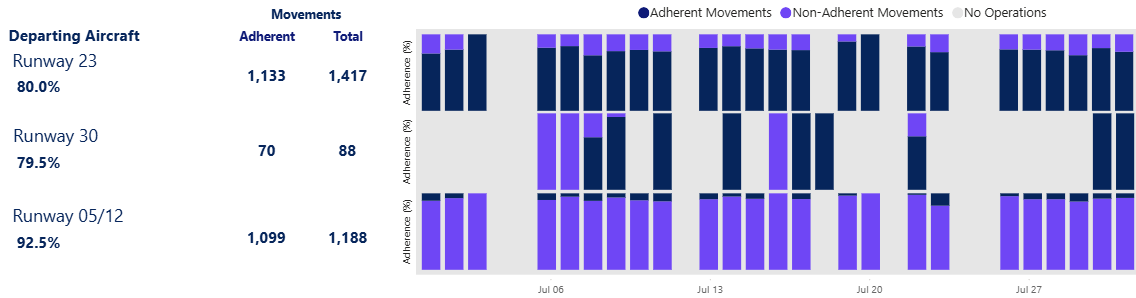
3.4 Departures
3.4.a: Runway 23
East: Jets maintain heading until 6nm, then via waypoint LEMAT. Non-Jets maintain heading until 3 nautical miles, then seaward of the coast and via waypoint LEMAT.
West: Maintain heading until 3 nautical miles.
3.4.b: Runway 30:
West: Maintain heading until 3 nautical miles.
3.4.c: Runway 12
No specific procedures apply.
No specific procedures apply.
3.4.d: Runway 23 or 30
East: Non-jets be at or above 3,000ft, jets to be at or above 5,000ft before crossing the coastline east bound.
Adherence with this procedure is reported below.
Note: A waypoint is a geographical location used to define a point on a flight path. Waypoints are defined by geographic coordinates and typically take the form of a five-letter capitalised word
Note: Air Traffic Control may adjust paths for weather and/or traffic conditions.
Standard Instrument Departures (SID) and Standard Instrument Arrivals (STARs) are published flight paths designed to enhance safety, efficiency, and predictability. Air traffic control (ATC) may issue a deviation to a SID or STAR due to weather and/ or traffic conditions.
The report below provides the percentage adherence against the NAP criteria for preferred flight paths; reporting is available from January 2025.
“Other Operations” refers to operations where adherence was unable to be determined.
The report is best viewed in full screen mode.
Note: Due to rounding, percentage values may not sum to exactly 100.0%. Minor discrepancies of up to ±1% are expected and do not indicate any errors in the underlying absolute figures, which remain accurate and unaffected. If there are no operations during the reporting period, the report below will show 0 adherent movements, 0 total movements and give a compliance of 0.0%.
2.1 Minimum heightsover densely populated areas (unless in the course of taking off or landing)
Jet aircraft: 5,000 ft
Non-jet aircraft: 3,000 ft
Note: This NAP is under review to determine how it can be reported.
2.2 Departures
Use standard departure paths (SIDs).
If not, fly as close as possible to those paths and follow height rules.
Adherence with this procedure is reported below.SID operations are reported up to 10,000ft adherence.
This NAP notes the need to “approximate” the SID where the procedural SID is not being flown. As we worked on defining the corridor that aircraft should be within for approximation, initial reporting on this NAP prior to 28 November 2025 were departures using the procedural SID corridor only without any variance for approximation. As such, reporting accessed prior to 28 November will show a lower adherence result.
2.3 Arrivals
Use standard arrival paths (STARs) where available.
Radar vectors allowed.
Adherence with this procedure is reported below.
Radar Vectoring – Air traffic controllers can sometimes guide a plane off the STAR route and give it specific headings (or “vector”) using radar to help it join the final runway-aligned landing path. Controllers do this to keep safe spacing between planes, manage traffic flow, and make the landing process more efficient.
This NAP notes that aircraft can be vectored at particular points which will take them off the STAR approach. As we worked on defining these points, initial reporting on this NAP prior to 28 November 2025 reported arrivals using STAR tracking only without variance for radar vectors. As such, reporting accessed prior to 28 November will show a lower adherence result.
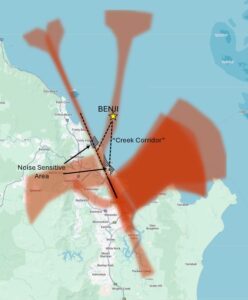
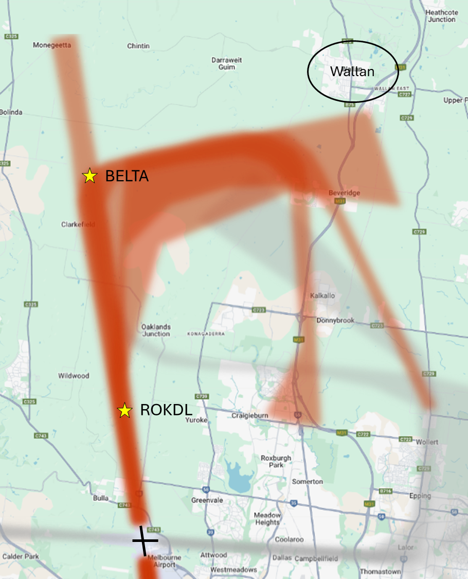
2.4Runway 16 arrivals (arrivals from the north east turning left onto the long north-south runway)
Use STAR via waypoint BELTA or
Visual track via waypoint ROKDL with restrictions:
no shortcutting early
avoid flying low over Wallan (if not possible, then jet aircraft should be at or above 6000 ft whenever practicable)
Note: A waypoint is a geographical location used to define a point on a flight path. Waypoints are defined by geographic coordinates and typically take the form of a five-letter capitalised word e.g. BELTA, ROKDL, PORTS.
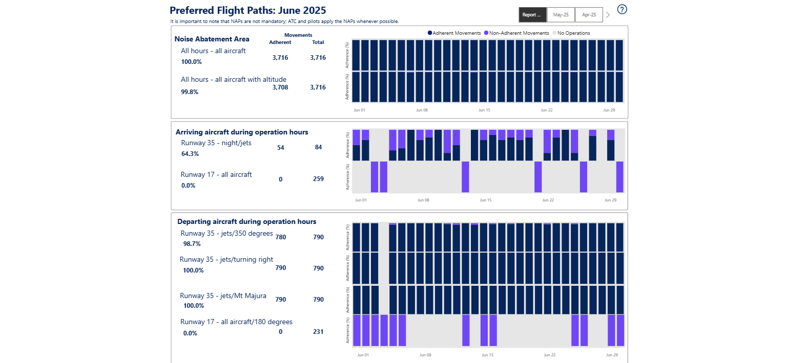
Adherence with this procedure is reported below.
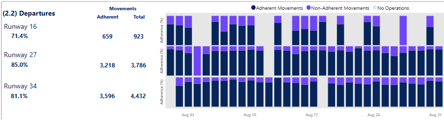
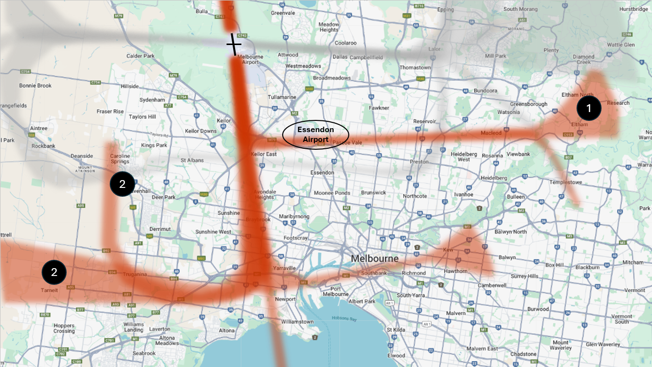
2.5Runway 34 arrivals (arrivals from the south onto the long runway)
(1) Aircraft turning right to land:
Use STAR via Essendon Airport, or if needed, may be radar vectored south of Essendon Airport to join the final runway aligned landing path
(2) Aircraft turning left or heading straight-in to land:
Must follow applicable STAR, or
between 6am–11pm only, may be radar vectored to join final runway-aligned section no closer than 3.5 Nautical Miles (roughly 6.5km) from touchdown
Adherence with this procedure is reported below.
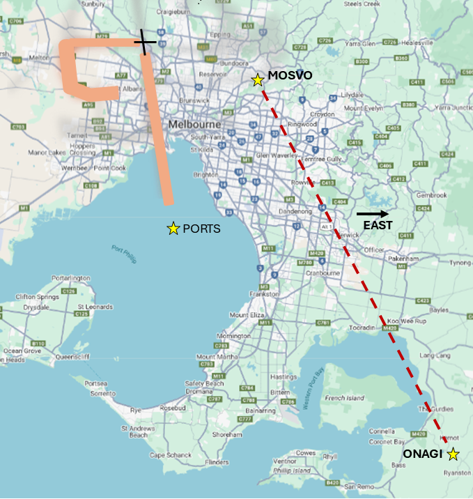
2.6 Night time arrivals (11pm–6am)
Southeast arrivals must stay east of the ONAGI–MOSVO line
Unless landing on Runway 09 or 34 using PORTS STAR
Adherence with this procedure is reported below.
Note: Air Traffic Control may adjust paths for weather and/or traffic conditions.
Standard Instrument Departures (SID) and Standard Instrument Arrivals (STARs) are published flight paths designed to enhance safety, efficiency, and predictability. Air traffic control (ATC) may issue a deviation to a SID or STAR due to weather and/ or traffic conditions.
The report below provides the percentage adherence against the NAP criteria for preferred flight paths.
“Other Operations” refers to operations where adherence was unable to be determined.
The report is best viewed in full screen mode.
Note: Due to rounding, percentage values may not sum to exactly 100.0%. Minor discrepancies of up to ±1% are expected and do not indicate any errors in the underlying absolute figures, which remain accurate and unaffected.
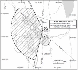
A designated Noise Abatement Area covers most of Canberra and Queanbeyan.
Preferred routing avoids this area whenever possible.
If aircraft must fly over the area:
Jet aircraft must stay above 7,000 feet AMSL.
Propeller aircraft over 5,700 kg maximum take-off weight must stay above 5,000 feet AMSL.
Note: The Noise Abatement Areas do not apply to: * Emergency or medical priority operations. * Operations avoiding hazardous weather. * TWR circuit training operations * Unplanned missed approach operations
(2.1.b) All hours – aircraft with minimum altitude
We have become aware of an error in the reporting of this NAP as the height of the aircraft was calculated using the height above ground rather than the height above mean sea level as stated in the NAP. We have corrected the results and backdated these to correct the error.
Adherence with this procedure is reported below.
2.2 and 2.3 Arrivals
Runways 35, 17, 30 and 12
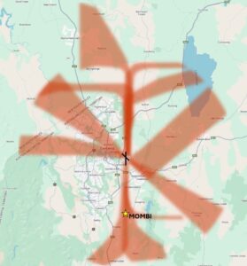
2.2.a: Runway 35: At night: jets will be vectored to be on final approach no closer than MOMBI.
2.2.b: Runway 17: Aircraft on right base will be vectored to be on final approach no closer than 4 DME CB.
2.2.c: No specific procedures apply.
2.3.a: Runway 35 or 17: IFR aircraft required to conduct a straight-in approach.
2.3.b: No specific procedures apply.
2.3.c: Data not available
NAP 2.2a – Night-time jets, Runway 35
We have identified that flights operating on the published Runway 35 RNP-AR procedure were being incorrectly flagged as non-adherent under this NAP. As this NAP applies only to vectored aircraft, RNP-AR flights should not be assessed against it. We have updated the methodology from March 2026 onwards to correctly classify these flights as adherent.
Adherence with this procedure is reported below.
2.4 and 2.5 Departures
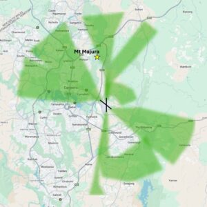
Runway 35 Departures
2.4.a.1: Jets will usually be assigned a heading of 350° after take-off.
2.4.a.2: Jets turning right must climb to at least 4,500 feet before turning.
2.4.a.3: Jets turning left must pass Mt Majura before starting the turn.
2.5.a.1: Jets will usually be assigned a heading of 353° (SID).
2.5.a.2: Jets must climb to at least 5,000 feet before turning.
Adherence with this procedure is reported below.
Runway 17 and 30 Departures
2.4.b: Runway 17: Heading of 180 degrees until clear of Noise Abatement Area.
2.5.b: Runway 17: Follow SID.
NAP 2.4b – Runway 17 departures, Noise Abatement Area
We have identified that Runway 17 departures overflying the Noise Abatement Area were being flagged as non-adherent regardless of altitude. A related procedure permits aircraft to overfly the area provided they meet minimum altitude thresholds (7,000 ft AMSL for jets; 5,000 ft AMSL for propeller aircraft over 5,700 kg). We have updated the methodology from March 2026 onwards to account for these altitude thresholds, and flights meeting them are now correctly classified as adherent.
Adherence with this procedure is reported below.
NAPs not currently reported on
Reporting options are currently under review for the following NAPs, where data is not currently available.
2.2.d: Pilot requirement for landing runway 12 during tower hours.
2.3.c: Pilot requirement for landing runway 12 outside tower hours.
2.4.c: Pilot requirement for departure runway 30 during tower hours.
2.4.d: Pilot requirement for departure runway 12 during tower hours.
2.5.c: Pilot requirement for departure runway 30 outside tower hours.
Note: Air Traffic Control may adjust paths for weather and/or traffic conditions.
Standard Instrument Departures (SID) and Standard Instrument Arrivals (STARs) are published flight paths designed to enhance safety, efficiency, and predictability. Air traffic control (ATC) may issue a deviation to a SID or STAR due to weather and/ or traffic conditions
The report below provides the percentage adherence against the NAP criteria for preferred flight paths.
The report is best viewed in full screen mode.
Note: Due to rounding, percentage values may not sum to exactly 100.0%. Minor discrepancies of up to ±1% are expected and do not indicate any errors in the underlying absolute figures, which remain accurate and unaffected.
All arriving and departing aircraft to track via a SID and STAR for aircraft above 5,700kg.
Arrivals (STAR)
Departures (SID)
Adherence with this procedure is reported below.
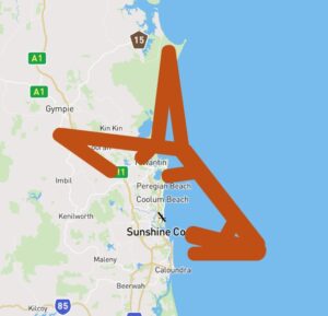
The Preferred Flight Paths Report below shows a historically low adherence of arrivals to Runway 31 following the preferred flight paths. This means that aircraft that are arriving to the runway over water are not following the preferred arrival flight path.
Our investigation of this low adherence shows that while arriving aircraft are following the arrival path over land, many of the aircraft that are approaching from southern destinations often deviate from the arrival flight path when over water.
Noise abatement focuses on methods to minimise aircraft impacts over land. As this deviation from the arrival flight path is occurring over open water, the operation remains consistent with the intent of the preferred flight paths NAP, being to avoid populous areas.
We are working to modify the collation and reporting of this data to better reflect the on-ground experience of noise abatement.
Note: Air Traffic Control may adjust paths for weather and/or traffic conditions.
Standard Instrument Departures (SID) and Standard Instrument Arrivals (STARs) are published flight paths designed to enhance safety, efficiency, and predictability. Air traffic control (ATC) may issue a deviation to a SID or STAR due to weather and/ or traffic conditions.
The report is best viewed in full screen mode.
Note: Due to rounding, percentage values may not sum to exactly 100.0%. Minor discrepancies of up to ±1% are expected and do not indicate any errors in the underlying absolute figures, which remain accurate and unaffected.
In 2020, Brisbane Airport opened a new parallel runway, which introduced new flight paths – designed to suit the orientation of both runways, the locations they would service, the types of planes that would use them and the typical wind conditions. This major airport infrastructure development shaped how Brisbane’s airspace works today.
Airservices Australia plays a vital role in managing Brisbane’s busy skies.
Our top priority is safety, while also balancing efficient operations, reducing environmental impact, and minimising aircraft noise.
The Brisbane airspace system is large and complex with many factors to consider.
At Airservices Australia, we are dedicated to providing safe, efficient and environmentally responsible services to the aviation industry and the community.
As Australia’s air traffic management and aviation rescue fire fighting service provider managing 11% of the world’s airspace, our primary focus is to ensure the safety of air travel both in the air and on the ground at airports.
Each year, millions of people travel to, from and within Australia, with about 3.9 million flights taking off and landing across the country.
Managing air travel—including safety, efficiency, environmental and community impact—is a shared responsibility. Government agencies, airlines and airports work together to balance these priorities.
At Airservices, our highly trained air traffic controllers manage flights at every stage—departure, enroute travel, and arrival—working together to keep planes safe in controlled airspace.
We provide air traffic services at 29 airports, across Australia. Our aviation rescue fire fighters are on standby at 27 airports, ready to respond to emergencies. Most of these airports operate 24/7 without restriction, but some have movement caps and curfews set by the Federal Government to manage local impacts.
At Airservices Australia, we are committed to ensuring safe, efficient, and responsible air travel while balancing the needs of communities and the aviation industry.
Australia’s skies are some of the busiest in the world, with millions of flights taking off and landing every year. At Airservices Australia, we work behind the scenes, safely managing air traffic in controlled airspace while considering noise impacts on communities.