Sunshine Coast Airport Community Forum

Federally-leased airports (excluding Mt. Isa and Tennant Creek) have established Community Aviation Consultation Groups (CACGs), which provide an effective avenue for local community engagement on airport planning and operations, including aircraft noise. The Department for Infrastructure, Transport, Regional Development and Communications provides guidelines for CACGs.

Non federally-leased airports may also choose to establish CACGs or community forums.

CACG membership depends on the characteristics of the airport and any local issues of community concern however, generally includes:

  • airport management
  • aircraft operators
  • community organisations or representatives
  • representatives from state, territory or local government bodies
  • local tourism and business groups.

Airservices does not formally belong to CACGs, but is invited to attend to provide relevant information and assist in discussions. We engage with CACGs on flight path and airspace changes, as well as technical reviews, such as noise monitoring and noise abatement procedures.

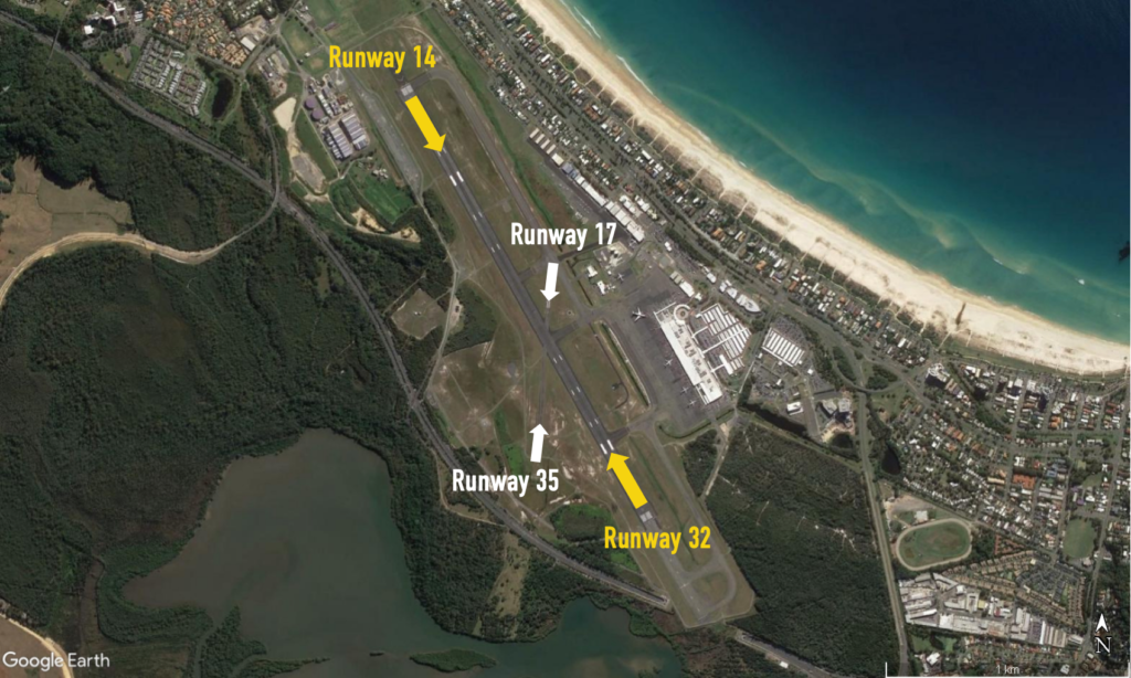
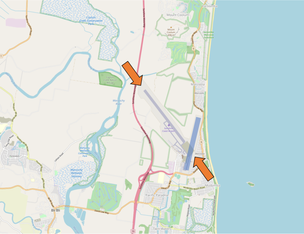
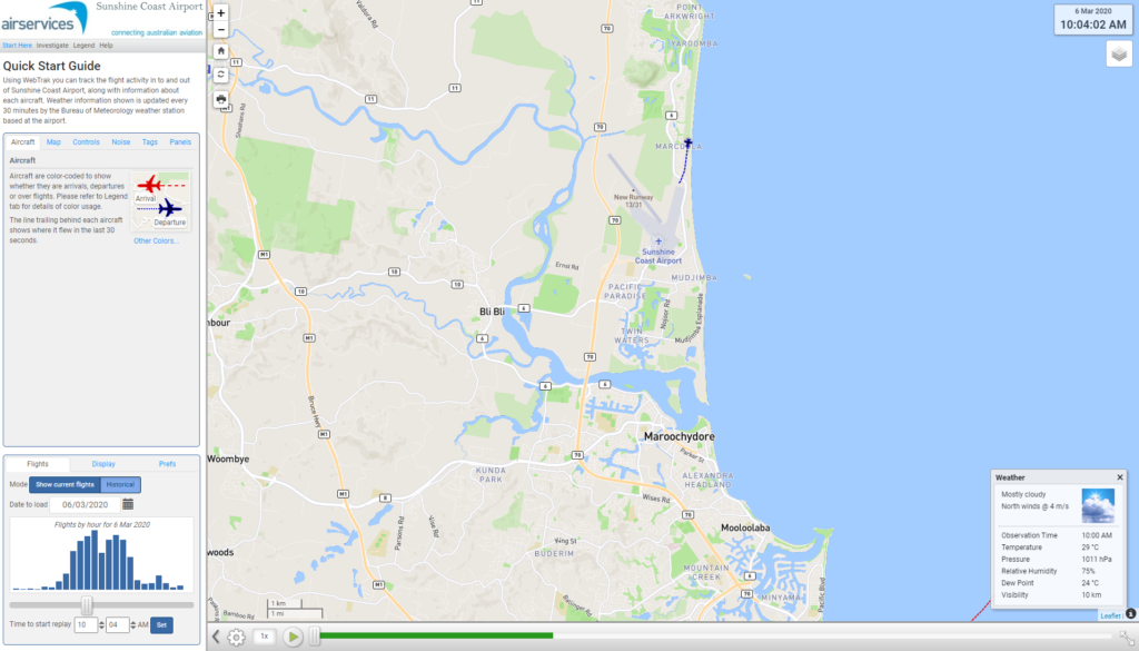
Find out more information on the Sunshine Coast Airport Community and Aviation Forum webpage.

Gold Coast Airport Community Forum

Federally-leased airports (excluding Mt. Isa and Tennant Creek) have established Community Aviation Consultation Groups (CACGs), which provide an effective avenue for local community engagement on airport planning and operations, including aircraft noise. The Department for Infrastructure, Transport, Regional Development and Communications provides guidelines for CACGs.

Non federally-leased airports may also choose to establish CACGs or community forums.

CACG membership depends on the characteristics of the airport and any local issues of community concern however, generally includes:

  • airport management
  • aircraft operators
  • community organisations or representatives
  • representatives from state, territory or local government bodies
  • local tourism and business groups.

Airservices does not formally belong to CACGs, but is invited to attend to provide relevant information and assist in discussions.  We engage with CACGs on flight path and airspace changes, as well as technical reviews, such as noise monitoring and noise abatement procedures.

Find out more information on the Gold Coast Airport Community Aviation Consultation Group webpage .

Gold Coast Airport Runway

Gold Coast Airport has two runways; the main runway, Runway 14/32 (2.3 km long) is orientated north west – south east and the smaller cross runway, Runway 17/35 (0.6km) is orientated north-south.

Each runway is referred to differently according to in which direction it is being used, as explained in the following video.

For example the main runway is known as Runway 32 when used in a northerly direction and Runway 14 when used in a southerly direction. Runway numbering reflects the runways’ orientation and correlates with degrees on a compass. Runway 32 is 320 degrees.

Runway selection and seasonal winds

Runway selection is based on wind direction, weather conditions, traffic volume and other factors. Aircraft primarily take-off and land into the wind for safety and performance reasons. Therefore, as the wind direction changes the runway in operation may also change depending on the strength of the wind.

This means that Gold Coast’s seasonal wind patterns affect usage of the different runway directions. Throughout most of the year, the wind at Gold Coast Airport tends to be from the south to south-east which means greater use of Runway 14 with aircraft departing to the south and arriving from the north. During the spring months, the wind tends to be from the north which means greater use of Runway 32 with aircraft departing to the north and arriving from the south.

Gold Coast Airport also operates a Curfew that restricts some aircraft operations during the night.

To learn more about the flight paths at Gold Coast Airport, take a look at our Gold Coast Airport flight paths page.

Gold Coast curfew and noise abatement procedures

Airport curfew

An airport curfew is a legislated restriction on aircraft operations at a federally-leased airport during a specified time period.

Gold Coast Airport is operational 24 hours a day, however, there is a curfew in place which restricts operations in and out of Gold Coast Airport during the hours of 11pm to 6am. During daylight saving time the airport curfew operates on Queensland time so New South Wales residents will see aircraft movements until 12 am instead of 11 pm.

While most aircraft operations are prohibited during this period, emergency aircraft, some small jets, propeller-driven aircraft and freight movements are allowed. The curfew limits what aircraft can land and take-off and, in some cases, the runways that can be used.

Curfew movements at Gold Coast Airport are small in number – on average less than one per night.

Curfews are legally enforceable and regulated by the Department of Infrastructure, Transport, Regional Development and Communications,  who can make a determination of a curfew violation and prosecute an airline or aircraft operator for breaching a curfew.

Noise Abatement Procedures

Every major airport has Noise Abatement Procedures (NAPs), which are procedures designed to reduce the impact of aircraft noise on the community. There are some limitations to the use of NAPs and they may not be used if they generate delay and congestion, as this can cause noise and emission impacts. Air traffic control or pilots may not be able to use them in certain situations, for example weather conditions or operational requirements. 

NAPs at Gold Coast Airport include:

  • runway 14 is the preferred runway for all arriving and departing flights
  • arriving aircraft fly over water for as long as possible before taking their final approach course
  • circuit training is not permitted between 10 pm and 6 am and, where possible, circuits are distributed equally left and right of the runway in use.

Gold Coast Airport also has specific NAPs for the use of the Instrument Landing System (ILS). Read more about these on our The Instrument Landing System page.

A ‘preferred runway’ does not mean that one area (north or south) will get all the traffic, because each area will get either departures or arrivals, not both. In addition, preferred runways can only be used when weather, safety and operational efficiency allow.

Runway 14 (arrivals from the north, departures to the south) is the preferred runway because generally arriving aircraft are slightly quieter than departing aircraft at a close distance to an airport (for example, at Tugun). As the distance from the airport increases (for example, Banora Point and Tweed Heads), departures tend to be quieter than arrivals because they are at a higher altitude. However this is dependent on aircraft type. Individual people will experience aircraft noise in different ways.

Fly Neighbourly Agreements

Fly Neighbourly Advice or Fly Neighbourly Agreements are voluntary agreements established between aircraft operators and communities or authorities (normally airports or local councils) to assist in reducing the impact of aircraft noise on local communities. Gold Coast Airport has a voluntary Fly Neighbourly Program which encourages pilots to fly in a noise sensitive way whenever possible.

The Gold Coast Noise and Flight Path Monitoring System (NFPMS)

We have commenced a Noise Monitoring Review for Gold Coast Airport.

The purpose of the Review is to:

  • Validate the operation of the two existing long-term noise monitors (Tugun and Banora Point)
  • Consider and assess community suggested locations for a third long-term noise monitor in the Tweed Heads region or another suitable location in the broader Gold Coast region
  • Provide findings to the Gold Coast Airport Noise Abatement Consultative Committee (ANACC)

For more information, including how to participate in the Review visit Engage Airservices.

We collect noise and operational data from two noise monitors (Environmental Monitoring Unit, EMU) around Gold Coast Airport. Noise monitors are listed below according to their location.

Access monthly data on our Gold Coast noise monitoring reports page.

TUGUN (EMU 1)

Captures arrivals to Gold Coast Runway 14 and departures from Gold Coast Runway 32.
The pattern of aircraft noise events recorded is relatively steady.
Click to enlarge image and use your back button to return to this page.

BANORA POINT (EMU 3)

Captures arrivals to Gold Coast Runway 32 and departures from Gold Coast Runway 14.

Click to enlarge image and use your back button to return to this page.


Learn more about monitoring aircraft noise on the Airservices website.

Sunshine Coast Airport Runway

Sunshine Coast Airport has one runway oriented North-West to South-East (Runway 13/31) which opened on 14 June 2020. The runway is shown in the image below with orange arrows at either end.

Each runway is referred to differently according to in which direction it is being used, as explained in the following video.

For example, the runway is referred to as Runway 13 when used in a south-easterly direction and Runway 31 when used in a north-westerly direction.

Runway numbering reflects the runways’ orientation and correlates with degrees on a compass. Runway 13 is at 130 degrees and Runway 31 is at 310 degrees.

The existing north-south runway (RWY 18/36) was de-commissioned when the new runway opened. The old runway is also shown in the image below in blue.


Learn more about seasonal changes in your area on our How seasonal variation affects your area page.

Sydney Airport flight paths – east and west flow

Suburbs to the immediate west of Sydney Airport are affected by aircraft arriving to (“east flow”) and departing from (“west flow”) the east-west runway.

Below: east flow (left) and west flow (right)
East flow West flow

Sydney’s seasonal wind patterns mean that you are more likely to experience arrivals in the warmer months and departures in the cooler months. This is because aircraft need to take off and land into the wind. You are also more likely to experience traffic in non-peak periods when the east-west runway is used whenever possible for noise sharing purposes. Non-peak periods are generally:

  • 6:00 – 7:00am,
  • 11:00 – 3:00pm, and
  • after 8:00pm.

These times may vary, however. There will also be days when the wind conditions make use of the two north-south parallel runways impossible, and on such days you are likely to experience heavy levels of traffic for prolonged periods.

Arrivals – east flow

Arriving aircraft must align with the runway from a considerable distance out from the airport, and fly straight in. This means that aircraft arriving to land on the east-west runway will always fly over suburbs such as Picnic Point, Penshurst, Hurstville, Bexley and Rockdale. The following image shows actual tracks of arriving aircraft.

Arrivals

Departures – west flow

Aircraft departing towards the west will turn to their heading when they reach 1,500 feet (for jets) or 800 feet (for non-jets). As different types of aircraft have different climbing abilities, they will reach this altitude at different points after take-off and therefore begin their turns at different points in the air. This has the effect of creating a spread of aircraft as can be seen in the image below.

If the aircraft is proceeding to destinations to the west such as Perth or south such as Melbourne it will maintain the runway heading for longer before turning.The following image shows actual tracks of departing aircraft.

Departures

Departures – north flow

When aircraft are departing from the westernmost of the parallel runways, non-jets (turbo-prop aircraft) that are heading for southerly or westerly destinations will turn left after departure when they reach the altitude of 600 feet. This will create a spread of aircraft, taking them over suburbs such as Kingsgrove, Beverley Hills and Peakhurst. This is illustrated in the track image below.

Non jet departures

What was that flight?

WebTrak is a tool that enables the community to see where aircraft fly and explore historical trends and patterns. WebTrak is provided by Envirosuite .

WebTrak uses information from air traffic control radars to display aircraft movements. The flight search and display function allows you to view aircraft flight activity over metropolitan areas. You can also:

  • locate your street address and have your home appear on the map
  • see noise levels of individual aircraft
  • view information about aircraft type, height, origin and destination
  • display an aircraft’s flight path and point of closest approach to your home
  • zoom in and out down to street level.

Note that there is a slight delay on the display of flights.

You can view WebTrak for your region here.

Or, find out more information about WebTrak and how to use it

How many aircraft fly near me?

This tool shows the number of flights each day over your area in the selected month compared to the average for last year.  The bottom axis shows the day of the month. Use the drop-down menu to change the selected month to see how movements have varied. Hover over each day to see flight numbers.

Sydney Airport departures

North flow
Jet and turbo-prop aircraft that are heading for destinations to the west, north and north-west will fly over or near your area after departure from Sydney Airport. This corridor is labelled D5 in the image, right. These flights are bound for destinations such as Dubbo, Perth, Adelaide, Darwin, Broome, Singapore, Kuala Lumpur, Dubai, Abu Dhabi, Hong Kong and Shanghai.

As shown in the image below of actual tracks of departing aircraft, there are two concentrated flight paths. One tracks towards Richmond, passing over suburbs such as Ermington, Baulkham Hills and South Windsor. The other tracks towards Katoomba over Parramatta, St Clair and South Penrith.

Aircraft will also fly on either side of these two flight paths. This traffic is being individually directed by air traffic control in order to manage the volume of aircraft in the airspace. For example, a slower aircraft may be moved off the main flight path in order to take it out of the way of a faster jet behind it.

Altitudes over your area will vary according to factors such as the weight of the aircraft and how heavily laden it is. For example, long-haul aircraft departing for Dubai will be much heavier than smaller aircraft heading to Perth or Adelaide due to fuel load and aircraft size and therefore they will climb more slowly. The maximum take-off weight (MTOW) for an Airbus A380 is 560,000kg and for a Boeing B747 it is 396,890kg. The MTOW of an A320 is 73,500kg and for an A330 it is 230,000kg.

While differences in weight will affect an aircraft’s climb rate, even the atmospheric conditions at the time can play a part in how quickly an aircraft can climb. When the weather is warm, the air is less dense and therefore there is less lift and the aircraft climbs more slowly.

Generally, the average altitude of an A380 over Parramatta is around 5,500 feet and over South Penrith around 9,000 feet. In contrast the average for the smaller A320 or B737 over Parramatta is around 6500 feet and over South Penrith around 14,000 feet.

Over Baulkham Hills an A380’s average altitude is around 7000 feet and over Richmond around 11,500 feet. An A320/B737 would be at an average of around 8,500 feet over Baulkham Hills and 15,000 feet over Richmond.

This image shows the tracks of departing aircraft:

Departures