The Sydney Noise and Flight Path Monitoring System (NFPMS)

We collect noise and operational data from twelve noise monitors (Environmental Monitoring Unit, EMU) around Sydney Airport. Noise monitors are listed below according to their location.

Access monthly data on our Sydney noise monitoring reports page.

Northern Monitors

Sydenham and St Peters
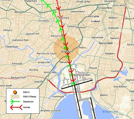
EMU 6 (Sydenham)

Sydenham (EMU 6)

Captures arrivals to Runway 16 Right and departures off Runway 34 Left. This monitor is closest to the threshold of Runway 16 Right/34 Left. The consistently high number of noise events reflects the high use of the main runway throughout the year.
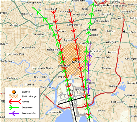
EMU 13 (St Peters)

St Peters (EMU 13)

Main purpose is to capture arrivals to Runway 16 Left, however it can capture movements from Runway 16 Right/34 Left and departures off Runway 34 Right.

This monitor captures many of the same operations as the Annandale monitor and demonstrates the same seasonal pattern. However, being closer to the runway it captures more aircraft noise events.
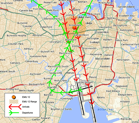
EMU 12 (Annandale)

Annandale (EMU 12)

Main purpose is to capture arrivals to Runway 16 Left, however it can also capture movements from Runway 16 Right/34 Left and departures off Runway 34 Right.

The pattern of aircraft noise events recorded at this monitor reflects the seasonal pattern use of Runway 16 Right, with generally more events recorded in summer than in winter.
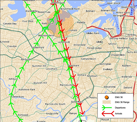
EMU 36 (Leichhardt)

Leichhardt (EMU 36)

Captures arrivals to Runway 16 Right.

This monitor is affected by the same operations as Hunters Hill monitor and reflects the seasonal pattern use of Runway 16 Right, with more events captured in summer than in winter.
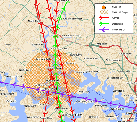
EMU 116 (Hunters Hill)

Hunters Hill (EMU 116)

Captures arrivals to Runway 16 Right.

The number of noise events recorded by this monitor reflects the seasonal pattern use of Runway 16 Right, with more events captured in summer than in winter.
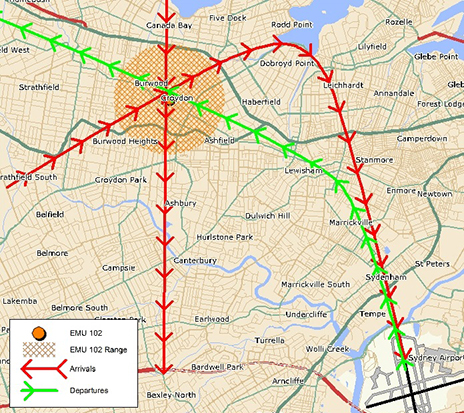
EMU 102 (Croydon)

Croydon (EMU 102)

Captures departures off Runway 34 Left.

The number of noise events recorded reflects the seasonal pattern use of Runway 34 Left with more aircraft noise events captured in winter than in summer.

Southern Monitors
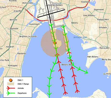
EMU 1 (Threshold Runway 34)

Threshold Runway 34 (EMU 1)

Captures departures off Runways 16 Right and 16 Left and arrivals to Runways 34 Left and 34 Right

The number of aircraft noise events captured reflects the pattern of use of Runway 34 Left, with more events generally recorded in winter than in summer.
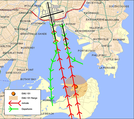
EMU 101 (Kurnell)

Kurnell (EMU 101)

Captures arrivals to Runway 34 Right and some arrivals to Runway 34 Left

Eastern Monitors
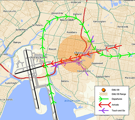
EMU 99 (Eastlakes)

Eastlakes (EMU 99)

Captures arrivals to Runway 25 and departures off Runway 07 and Runway 34 Right.

The pattern of aircraft noise events recorded reflects the seasonal use of Runway 34 Right, with more movements in winter than in summer.
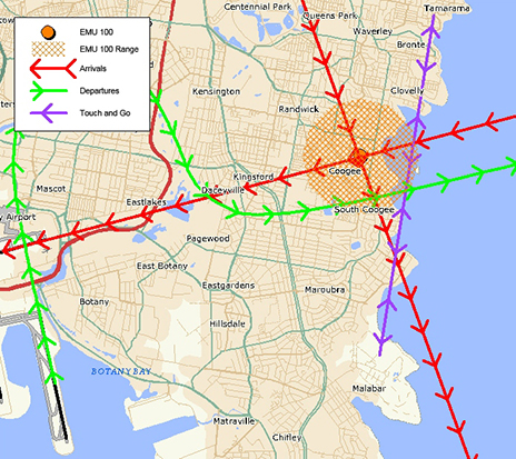
EMU 100 (Coogee)

Coogee (EMU 100)

Captures arrivals to Runway 25, departures off Runway 07 and Runway 34R heading to the east and south.

Captures noise from similar operations and reflects the same seasonal pattern to the Eastlakes monitor, however being further east from the airport the number of noise events recorded is smaller.

Western Monitors
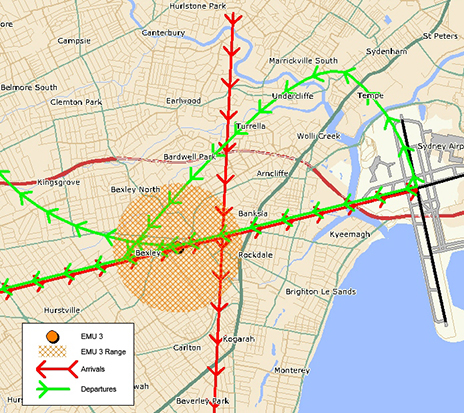
EMU 3 (Bexley)

Bexley (EMU 3)

Captures arrivals to Runway 07 and departures off Runway 25.

This monitor is closer to the runway than the Penshurst monitor, therefore it displays the same trends but records more aircraft noise events.
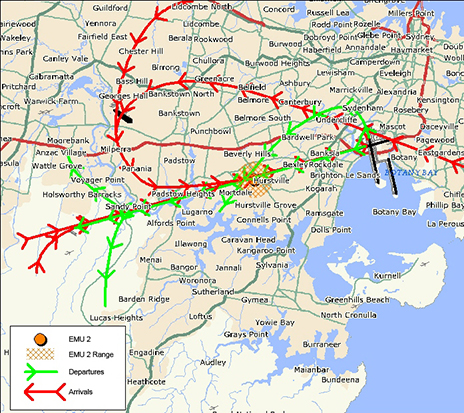
EMU 2 Penshurst

Penshurst (EMU 2)

Captures arrivals to Runway 07 and departures off Runway 25.

Historically at Sydney Airport there are fewer departures off Runway 25 than the other Runways.


Learn more about monitoring aircraft noise on the Airservices website.

Typical FAQs

We have assembled a list of our commonly asked questions that are asked in most areas.

Why can aircraft fly at sensitive times?

Aviation is a vital industry for the Australian economy.  Business, tourism, social and freight activities rely on aviation. Unlike many other industries, aviation is regulated by the federal government rather than by state governments.  This makes aircraft noise regulation quite different from the type of noise regulation you are used to at a local level that might, for example, prohibit noisy activities before 8:00 am on a Sunday.

Major airports in Australia are situated very close to residential areas and for this reason it is not possible to design flight paths that avoid flying over homes.  In cities where the airport is located on the coast, flight paths will be designed to fly over water wherever possible. However because aircraft must take off and land into the wind, it is not always possible to avoid flying over residential suburbs by staying over water.

Aircraft noise remains a key challenge for an industry that is forecasting high levels of growth in air traffic movements over the next 20 years. Managing noise impacts on communities requires careful balance between the protection of affected residents and recognition of the broader economic and social contributions of the aviation activity.

Why can’t the flight paths be moved away from me?

Flight path design is a complex process.  Flight paths must comply with international design standards and Australian safety regulations.  Changes to flight paths may be made for a variety of reasons, including safety and noise management.  However, changes are not easy to make as changes to one flight path usually impact other flight paths. 

In considering any change, first of all we must have regard to safety – any change that could compromise safety cannot be progressed. Managing aircraft in a regular way and minimising complexities are central tenets of safety. We also consider the efficient operations of the airport and whether there would be an overall noise improvement for the community. We do not generally consider that moving noise from one part of the community to another is a noise improvement. In considering this we have to have regard to the entire flight path and the fact that moving it at one point may result in adverse effects many kilometres away. Unfortunately, the reality is that it is very difficult to identify flight path changes in metropolitan areas that can be made without moving the noise, or compromising safety or efficiency.

If a potential change is identified it must be environmentally assessed, the community, including potentially affected areas, the airlines and other stakeholders must be consulted and feedback from all must be considered. Finally, if the change is to go ahead, aeronautical documents for pilots must be produced and published and time allowed for crews and air traffic controllers to be trained in the new procedures. All these requirements mean that changes can take several years to make.

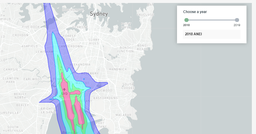
Sydney Airport Australian Noise Exposure Index (ANEI)

We are responsible for developing Australian Noise Exposure Index (ANEI) contours for Sydney Airport. ANEI contours are based on historical data and show the average daily aircraft noise exposure over the specified period.

The ANEIs for 1 January 2018 to 31 December 2024 are shown below.

Earlier ANEI Reports

Previous reports are available on request.

Technical Information

The ANEI contours were generated using United States Federal Aviation Administration (US FAA) Airport Environmental Design Tool (AEDT)

The following key inputs were used to develop the AEDT model:

  • the default Sydney Airport layout was used in AEDT, which contained data for runway ends and thresholds – the helipad location was manually added at – 33.94 latitude, 151.19 longitude and elevation of 20 feet
  • aircraft movement data and radar flight tracks for the year were input from our Noise and Flight Path Monitoring System (NFPMS)
  • standard arrival and departure profiles were used
  • aircraft vertical profiles (i.e. stage lengths) were based on the distance travelled to or from each origin destination
  • where possible, the correct aircraft types in AEDT were used to represent actual aircraft movements – some aircraft types that do not exist in AEDT version 2d were substituted based on similar size and weight
  • default meteorological conditions in AEDT were used
  • terrain information was incorporated into the model.

Archived Sydney Airport Operational Statistics Reports


Reports and statistics for earlier periods are available by request through the online portal on the Airservices website. A fee may apply.

The Perth Noise and Flight Path Monitoring System (NFPMS)

We collect noise and operational data from six noise monitors (Environmental Monitoring Unit, EMU) around Perth Airport. Noise monitors are listed below according to their location.

Access monthly data on our Perth noise monitoring reports page.

CANNINGTON (EMU 1)

Captures arrivals to Perth Runway 03 and departures from Perth Runway 21.

EMU 1 and EMU 2 are overflown by similar aircraft. However, EMU 2 is located closer to, and aligned with, Runway 03/21, which results in it recording higher noise levels.

QUEENS PARK (EMU 2)

Captures arrivals to Perth Runway 03 and departures from Perth Runway 21.

Along with EMU 5 (Guildford), EMU 2 records the highest noise levels of all the noise monitors in Perth – these two noise monitors are closest to the end of the runways.

GREENMOUNT (EMU 4)

Captures arrivals to Perth Runway 24 and departures from Perth Runway 06.

The seasonal variation in the use of Runway 06/24 is reflected in the values recorded at this monitor.

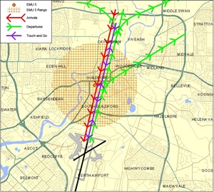
GUILDFORD (EMU 5)

Captures arrivals to Perth Runway 21 and departures from Perth Runway 03.

Together with EMU 2, EMU 5 records the highest levels of all the noise monitors in Perth. These two monitors are closest to the end of runways and are overflown by both arrivals and departures.

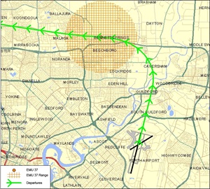
BEECHBORO (EMU 37)

Captures departures from Perth Runway 03.

Noise levels at EMU 37 are lower than at other noise monitors due to it being further from the end of a runway. This noise monitor is set only to capture those departures from Runway 03 that turn to the west.

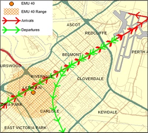
LATHLAIN (EMU 40)

Captures arrivals to Perth Runway 06 and departures from Perth Runway 24.

The noise levels at EMU 40 are generally low, due to it being aligned with the cross-runway (06-24) at Perth Airport which is used much less than the main runway.


Learn more about monitoring aircraft noise on the Airservices website.
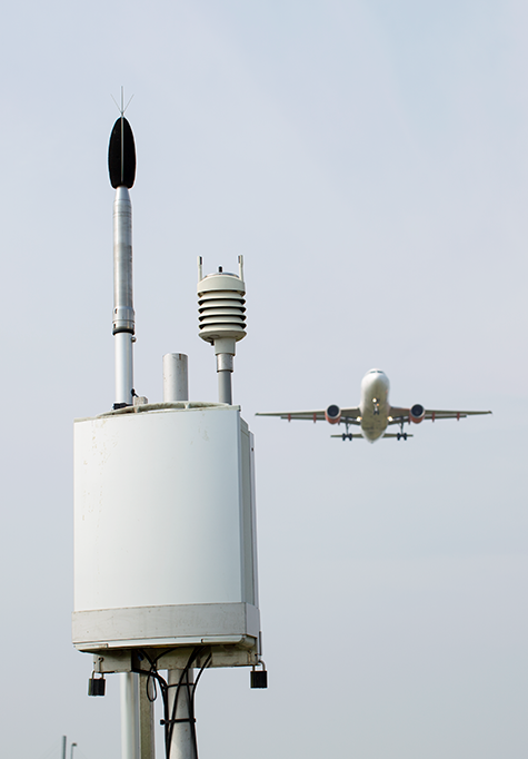
The Cairns Noise and Flight Path Monitoring System (NFPMS)

noise and operational data from three noise monitors (Environmental Monitoring Unit, EMU) around Cairns Airport at the following locations.

Access monthly data on our Cairns noise monitoring reports page.

HOLLOWAYS BEACH (EMU 2)

EMU 2 captures arrivals to Runway 15 and departures from Runway 33.

The number of aircraft noise events recorded by EMU 2 reflects the pattern of
seasonal use of Runway 15 for arrivals, with more events recorded in the dry
season than the wet season.

CAIRNS NORTH (EMU 3)

Captures arrivals to Runway 33 and departures from Runway 15.

YORKEYS KNOB (EMU 9)

EMU9 captures mainly arrivals to Runway 15 and departures from
Runway 33.

Although it captures many of the same movements as EMU 2 (Holloways
Beach), EMU 9 is further north and therefore aircraft are higher, resulting in
fewer aircraft generating a noise level above 80 decibels.


Learn more about monitoring aircraft noise on the Airservices website.
How runways are selected?

Weather, in particular wind speed and direction, is generally the main factor in determining which runways are in use at an airport, in which direction aircraft will take off and land and which flight paths are used.

At all times, the safe operation of aircraft will be the primary consideration.

Runway naming

Runways are named using a numbering system which reflects the runways’ orientation. The number, between 01 and 36, correlates to the degrees on a compass, for example:

  • A runway numbed 09 points east at 90 degrees
  • A runway numbered 27 points west at 270 degrees.

Some airports will have additional runways side-by-side, in this case the letters, left, right and even center are used to differentiate the different runways.

Runway use

Runways can be used in both directions and a runway will have a different name to refer to each end. In the above example the runway runs east-west, with runway 09 pointing east and 27 pointing west.

How can I find out more?

You can read more in our factsheet, available here.

How is airspace used?

Each year we manage domestic and international air traffic operations for over 140 million passengers on more than four million aircraft movements in a region covering 11 per cent of the world’s surface. The following video shows what 24 hours of operations looks like:

Controlled and uncontrolled airspace

Airspace is designated as either:

  • Controlled airspace which is actively managed by air traffic controllers and is broken up into a number of different classes or classifications. To enter controlled airspace, an aircraft must first gain a clearance from air traffic control.
  • Uncontrolled airspace which requires no clearance (or supervision by air traffic control) to operate. The large majority of light aircraft and helicopters operate outside or underneath controlled airspace (for example, aircraft that operate at low levels over Sydney Harbour).

Terminal Airspace

Terminal airspace is the controlled airspace surrounding a major airport, generally within a 30–50 nautical miles (55–90 kilometres) radius. In the case of some major airports, this airspace extends from ground level up to 18,000 feet (approximately 6,000 metres).

As the distance from the airport increases, the lower boundary of this airspace rises in steps, enabling other airspace users (such as gliders and balloons) to operate outside terminal airspace without requiring an air traffic clearance.

Restricted Airspace & No fly zones

In restricted airspace, aircraft movements are restricted in accordance with certain specified permissions. Examples of restricted airspace include airspace around military installations and high density flying operations at an air show or other large public event.

Restricted airspace may be imposed by police for safety or security reasons in the vicinity of bushfires or major crime scenes. Decisions on restricted airspace are made by the Civil Aviation Safety Authority.

No-fly zones are similar to restricted airspace but are imposed and enforced by the military (usually the Royal Australian Air Force). No-fly zones will often be established around military exercises, heads of government meetings and major events such as the Olympic or Commonwealth Games. Airservices has no authority or control over no-fly zones.

Find out more

Read more about our operations in our Guide to our operations booklet.

The Adelaide Noise and Flight Path Monitoring System (NFPMS)

We collect noise and operational data from five noise monitors (Environmental Monitoring Unit, EMU) around Adelaide Airport.

Long term noise monitors are listed below according to their location.

Access monthly data on our Adelaide noise monitoring reports page.

BROOKLYN PARK (EMU 1)

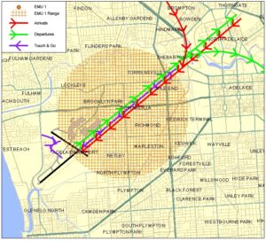
Captures arrivals to Runway 23 and departures from Runway 05.

The pattern of noise events reflects the number of departures from Runway 05.

MEDINDIE (EMU 2)

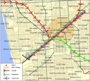
Captures arrivals to Runway 23 and departures from Runway 05.

NETLEY (EMU 3)

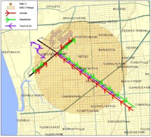
Located to the south east of the cross runway.

Due to the low level of use of the cross runway, most of the noise events captured are associated with arrivals to Runway 05.

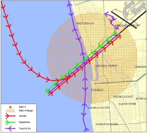
GLENELG NORTH (EMU 4)

Captures arrivals to Runway 05 and departures from Runway 23.

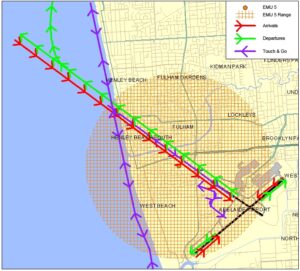
WEST BEACH (EMU 5)

Located to the north west of the cross runway.

Most of the noise events captured by this noise monitor are associated with departures from Runway 23.


Learn more about monitoring aircraft noise on the Airservices website.