What was that flight?

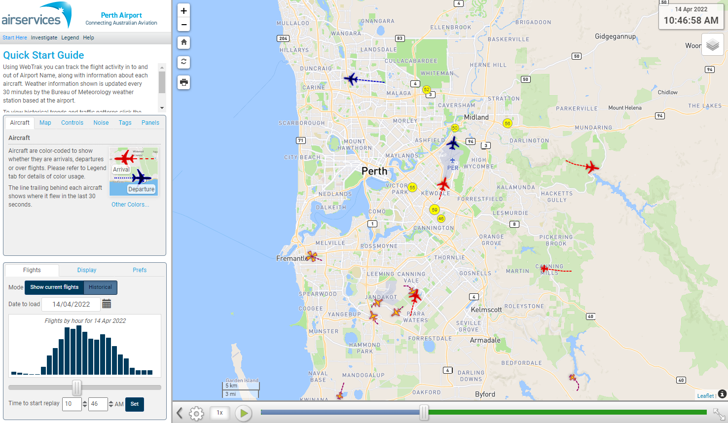
WebTrak is a tool that enables the community to see where aircraft fly and explore historical trends and patterns. WebTrak is provided by Envirosuite.

WebTrak uses information from air traffic control radars to display aircraft movements. The flight search and display function allows you to view aircraft flight activity over metropolitan areas. You can also:

  • locate your street address and have your home appear on the map
  • see noise levels of individual aircraft
  • view information about aircraft type, height, origin and destination
  • display an aircraft’s flight path and point of closest approach to your home
  • zoom in and out down to street level.

Note that there is a slight delay on the display of flights.

You can view WebTrak for your region here.

Or, find out more information about WebTrak and how to use it.
How frequent are flights in my area?

There are a number of factors that influence the frequency of flights.

Firstly, the number and frequency of flights will vary on a daily, weekly and yearly basis due to differences in airline schedules. The airlines schedule flights in response to consumer demand. This is particularly the case around Christmas, Easter, school holidays and Lunar New Year.

Secondly, the runway in use at any given time will also vary, largely due to the wind conditions. Each runway has its own set of flight paths, and each flight path will affect different areas. As the runway in use changes, the flight paths change, and so too do the areas affected by aircraft movements.

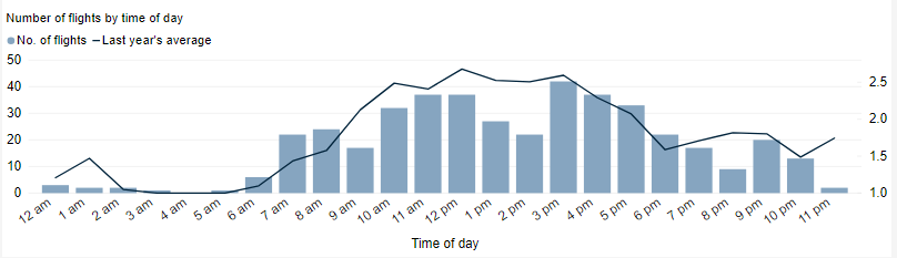
This chart shows the total number of flights each hour over the month, compared to the average for last year. Change the selected month to see how it has varied.

*Please note due to technical issues between 19 June and 22 June 2024, flight data may not be accurately displayed. Our supplier is working to resolve the issue. We apologise for any inconvenience this may cause.

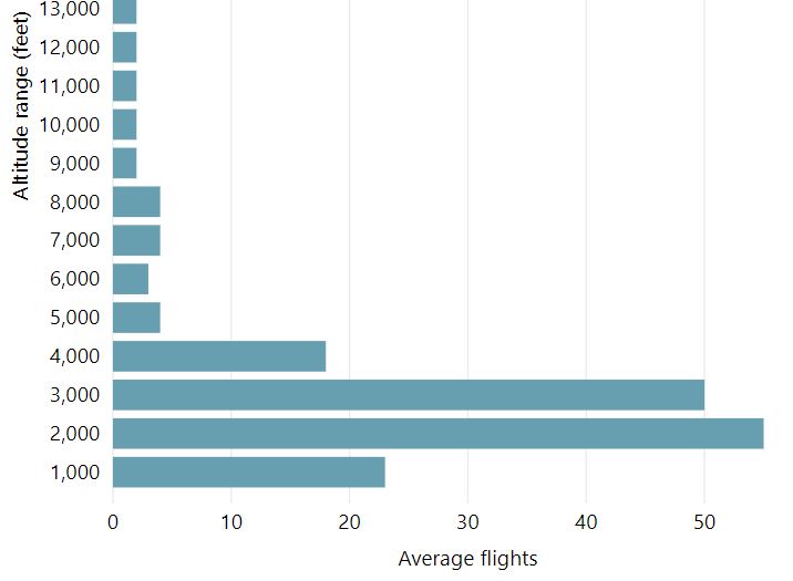
How high are aircraft near me?

The altitudes of aircraft over your area can vary according to:

  • the airport the flight is coming from or going to
  • whether the aircraft is arriving, departing or in level flight
  • the specific requirements of the flight path
  • the need for air traffic control to maintain vertical separation between aircraft.

Find out more on our What are the rules about altitudes? page.

*Please note due to technical issues between 19 June and 22 June 2024, flight data may not be accurately displayed. Our supplier is working to resolve the issue. We apologise for any inconvenience this may cause.

Explore detailed data for your area

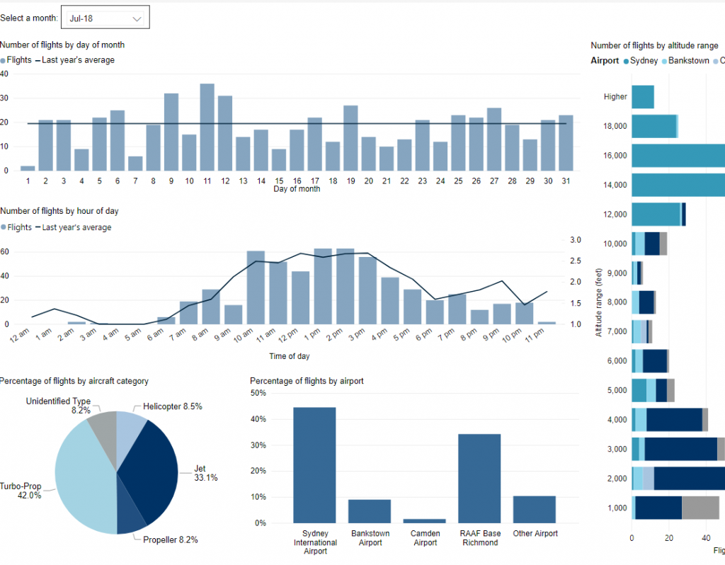
Use this interactive tool to explore detailed data for your area in the month of your choice.

This report is best viewed in full screen mode.

*Please note due to technical issues between 19 June and 22 June 2024, flight data may not be accurately displayed. Our supplier is working to resolve the issue. We apologise for any inconvenience this may cause.

Investigation: Direct tracking to Runways 21 and 24

The practice of direct tracking arrivals to Runways 21 and 24 over Stoneville and Parkerville, northeast of the airport, was addressed. “Direct tracking” involves taking an aircraft off the standard flight path and giving it a shorter route. This now only occurs when it is operationally required, for example, for traffic management reasons to ensure separation is maintained.

Investigation: Eastern departures to maintain 8000 feet

Noise Abatement Procedures at Perth allow aircraft to be taken off Standard Instrument Departure (SID) procedure tracking once jets are at 5000 feet above ground level and non-jets 3000 feet except where impractical in the normal course of operation to and from the runways. This provision is primarily in place to assist the efficient management of aircraft close to the airport during peak periods.

In response to community concerns about the minimum height of aircraft over residential areas, Airservices held a trial from December 2013 to February 2014 for all aircraft flying to the east of Perth to maintain SID tracking until leaving 8000 feet except where required for operational reasons.

A Post Implementation Review of the trial was completed in December 2014. While community feedback was limited, Airservices concluded there was a noticeable benefit from the trial and that the change should be permanently implemented in Perth Airport’s Noise Abatement Procedures. This change was permanently implemented on 28 May 2015.

Investigation: Roleystone – modified flight path

Airservices identified an opportunity to modify the flight path for aircraft arriving from the north to land on the southern end of the Runway 03 at Perth Airport which would move aircraft away from Bickley, Byford, Carmel, Martin and Roleystone and closer to Bickley East, Karragullen and Pickering Brook which had smaller populations.

Post Implementation Review of the trial was published in February 2015. The review found that community feedback demonstrated a noticeable benefit had been achieved from the trial and that as a result the change should become permanently implemented. Airservices actioned this on 5 March 2015.

Investigation: Moving the converging point for eastern arrivals to Runway 03

Arriving aircraft from the east that are making an instrument approach to Runway 03 (long straight-in approach to the southern end of the main runway) converged at a point near Bedfordale. Airservices proposed to move this converging point some 8-10 kilometres to the east to reduce the number of aircraft impacting the Bedfordale area. This change came into effect on 5 March 2015.

Will flights increase in the future in my area?

Flight Path and Airspace Changes

Visit Engage Airservices to engage with our program of flight path and airspace changes.

Airport Master Plans

Airport Master Plans provide a blueprint for the future development of an airport over a twenty year period. They include information on forecast growth, airport terminals and facilities, runways and flight paths.

Who is responsible for master planning?

Airports are responsible for producing the master plan.

Perth Airport

The Perth Airport Master Plan can be found on the Perth Airport website.

Jandakot Airport

The Jandakot Airport Master Plan can be found on the Jandakot Airport website.

Investigation: Preferred runway under the Noise Abatement Procedures

Perth Airport Noise Abatement Procedures are used by pilots and air traffic control to minimise the impact of aircraft noise on residential areas. The procedures nominate which runways and flight paths are preferred for arriving and departing aircraft. In May 2015 the procedures were amended to accommodate changes to the preferred runway system.

Airservices review of Perth Airport’s noise abatement procedures found the wording on runway preferences did not consistently match the operational requirement of managing the flow of aircraft to and from the airport (in the air and on the ground).

The old procedures specified that Runway 21 (arriving over Guildford) and Runway 24 (arriving over Greenmount) were equally preferred for arrivals and Runway 21 (departing over Queens Park) was the only runway preferred for departures. Arrivals to Runway 06 (over Redcliffe) and departures from Runway 24 (over Redcliffe) were least-preferred due to the close proximity of residential areas at the southern end of the cross runway.

The procedures now give equal preference to arrivals to Runway 21 (over Guildford), Runway 24 (over Greenmount) and Runway 03 (over Queens Park). For departures, equal preference is given to Runway 21 (over Queens Park), Runway 03 (over Guildford) and Runway 06 (over Greenmount). Arrivals to Runway 06 (over Redcliffe) and departures from Runway 24 (over Redcliffe) have been maintained as being least-preferred.

The Post Implementation Review of this change was completed in October 2016 after one year of operations.

Read the Post Implementation Review – Perth Preferred Runways

Read the Terms of Reference for the Post Implementation Review