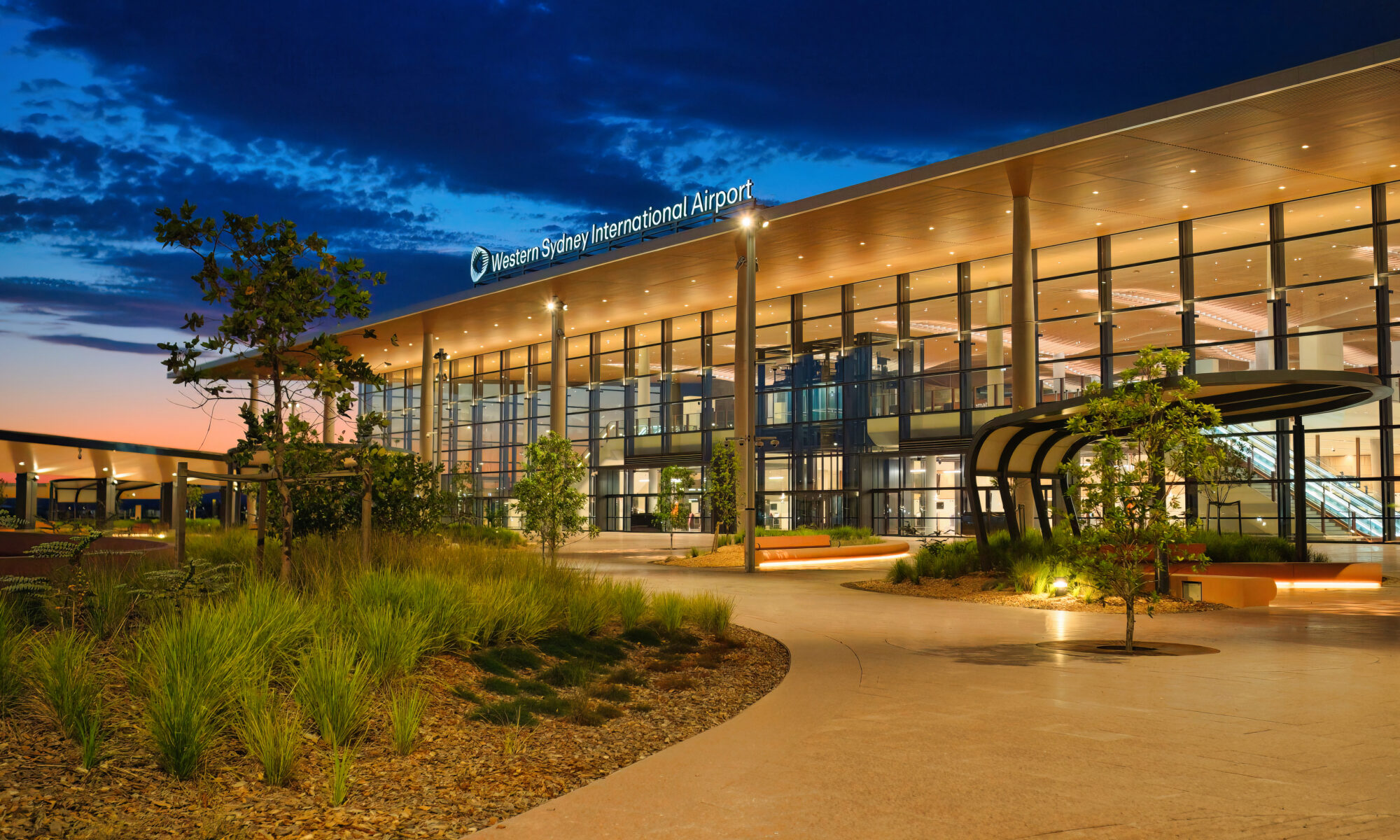
Western Sydney Airport Community Aviation Consultation Group (CACG)

Federally-leased airports (excluding Mt. Isa and Tennant Creek) have established Community Aviation Consultation Groups (CACGs), which provide an effective avenue for local community engagement on airport planning and operations, including aircraft noise. The Department for Infrastructure, Transport, Regional Development, Communications, Sports and The Arts provides guidelines for CACGs.

Non federally-leased airports may also choose to establish CACGs or community forums.

CACG membership depends on the characteristics of the airport and any local issues of community concern however, generally includes:

  • airport management
  • aircraft operators
  • community organisations or representatives
  • representatives from state, territory or local government bodies
  • local tourism and business groups.

Airservices does not formally belong to CACGs but is invited to attend to provide relevant information and assist in discussions. We engage with CACGs on flight path and airspace changes, as well as technical reviews, such as noise monitoring and noise abatement procedures.

Find out more information on the WSI Community Aviation Consultation Group (CACG).

Useful documents and websites

Further information about aircraft operations

You can find a range of information on the Airservices website.

Accessing earlier noise and complaint information reports

Our interactive noise and complaint reports include data from 1 January 2017. Previous reports are available on request.

Understanding noise and annoyance – video

Everyone encounters sound every day. It is only when that sound causes an adverse effect on a listener, such as annoyance, does that sound become noise. Noise is not always just about how loud the sound is, there is a complex set of factors that drive annoyance both based upon the noise itself and what that noise means to us. Find out more by watching this video:

From the ATC archives – video

Take a look at how air traffic control and flight operations used to operate.

Introduction to aircraft noise

Although the terms noise and sound can be used interchangeably, noise is used to refer to an unwanted sound, while sound is the generic term used to refer to anything acoustic.

In the case of aircraft noise, the acoustic energy can pass through 500 metres to 10 kilometres (or more) of air to reach local communities. As a result an aircraft can sound very different depending on the distance between the community and the aircraft, be that at flying or on the ground at a nearby airport.

The following video explains how aircraft noise is generated and how the characteristics of sound from aircraft can vary depending on a range of factors, such as the height of the aircraft, the type of aircraft (jet/propeller), its speed and weather:

If you would like to read more about aircraft noise and how we monitor it, you can visit our aircraft noise webpage.

Western Sydney Area FAQs

Why is there no curfew for WSI?

WSI has always been planned and approved to operate on a 24/7 curfew-free basis. Operating without a curfew will boost the airport’s ability to create more jobs in Western Sydney and meet the demand for aviation services in the region. Curfews are outside the remit of Airservices Australia, and are legislated by the Federal Parliament. The Australian Government has reaffirmed its commitment not to impose any additional operating constraints on airports, such as curfews or movement caps, where they currently do not exist (Aviation White Paper 2024). For more information, visit: airservicesaustralia.com/about-us/about-our-operations/airport-curfews

Changes to Sydney Airport Curfew

  • It has been legislated since 1995 that the standing exemptions to the 11pm to 6am curfew at Sydney Airport would cease once the Minister gazettes a date on which WSI is available for night flights.
  • Minister Catherine King has given advance notice that 1 November 2026 will be this gazettal date for WSI.
  • This will cease all flights landing or departing from Sydney Airport between 11pm and 6am from 1 November 2026 unless they are for emergencies or have been granted an exceptional circumstances dispensation by the Department of Infrastructure, Transport, Regional Development, Communications, Sport and the Arts.

Noise Insulation Program

The Department of Infrastructure, Transport, Regional Development, Communications, Sport and the Arts is responsible for the Noise Insulation Program and are leading the engagement with landowners. To find out more visit: wsinoiseinsulation.gov.au or email wsinoiseinsulation@infrastructure.gov.au

Will the flight paths change in the future? 

As part of standard practice, Airservices Australia conducts a Post Implementation Review (PIR) following the introduction of significant airspace changes. A PIR for WSI  will be undertaken within two years of airport operations to confirm alignment with planned practices and identify opportunities for further noise mitigation or operational improvements. This includes ongoing operational monitoring to ensure safety and efficiency. The review will also incorporate feedback from a range of stakeholders, including aviation operators, the Department of Defence, CASA, the WSI Community Aviation Consultation Group (CACG), and local communities.

Are the flight paths different for freight and passenger planes? 

No. In general, the same flight paths will be used for both freight and passenger aircraft. Some routes may be designated for non-jet aircraft (e.g. regional turboprops). However, most aircraft operations will share the same flight path network. 

What was the flight paths development process? 

The Department for Infrastructure, Transport, Regional Development, Communications, Sport and The Arts (the department) is responsible for the Environmental Impact Statement (EIS) for the preliminary flight paths and airspace changes for WSI.   

The department released the draft EIS on 24 October 2023 for public consultation and conducted extensive community and stakeholder engagement on the draft EIS. More details on the scope of the consultation can be found in Chapter 9 Community and Stakeholder Engagement of the EIS. 

The Minister for Infrastructure, Transport, Regional Development and Local Government, The Hon. Catherine King MP, released the final EIS on 7 October 2024

Minister King authorised the flight paths as presented in the EIS for implementation on 4 June 2025. 

With the authorisation, Airservices completed detailed design and implementation of these flight paths supported by comprehensive community and stakeholder engagement. The flight paths and airspace changes came into effect on 9 July 2026. 

Freight operations at WSI – when does it start and what can I expect? 

WSI opened for freight operations on 26 July 2026. Freight operations refer to aircraft carrying goods only and do not include passenger aircraft carrying cargo. Flights are operating both during the day and at night, with frequencies likely to vary between weekdays and weekends. The airport operator and airlines are responsible for determining flight schedules.

Passenger operations – when does it start and what can I expect? 

Passenger services at WSI will commence on 25 October 2026, including both domestic and international flights. Airlines and the airport will determine flight schedules. Please refer to the airlines’ websites for schedules and flight information. 

How many flights can I expect in the first year? 

According to the EIS, in the first year of operations an estimate of 33,000 aircraft movements is expected. This is equivalent to around 90 flights per day or four per hour. This number is expected to increase over time as more airlines begin operating at WSI. 

Airservices has no oversight of flight schedules and is not able to influence airlines to schedule flights for any particular time or frequency. 

Which other flight paths changed and how? 

The Sydney Basin manages the highest volume of air traffic in the country. For safety reasons, the introduction of WSI’s flight paths has required some minor adjustment to airspace across the Sydney region. These modifications are essential to seamlessly integrate WSI’s flight paths with the wider network and were the subject of extensive environmental assessment and community engagement.

Some community members may notice some of the changes, but overall they are not expected to be significantly different from current conditions.

The changes also do not alter the current Long Term Operating Plan (LTOP) at Sydney Airport.

Typical FAQs

We have assembled a list of our commonly asked questions that are asked in most areas.

Why can aircraft fly at sensitive times?

Aviation is a vital industry for the Australian economy.  Business, tourism, social and freight activities rely on aviation. Unlike many other industries, aviation is regulated by the federal government rather than by state governments.  This makes aircraft noise regulation quite different from the type of noise regulation you are used to at a local level that might, for example, prohibit noisy activities before 8:00 am on a Sunday.

Major airports in Australia are situated very close to residential areas and for this reason it is not possible to design flight paths that avoid flying over homes.  In cities where the airport is located on the coast, flight paths will be designed to fly over water wherever possible. However because aircraft must take off and land into the wind, it is not always possible to avoid flying over residential suburbs by staying over water.

Aircraft noise remains a key challenge for an industry that is forecasting high levels of growth in air traffic movements over the next 20 years. Managing noise impacts on communities requires careful balance between the protection of affected residents and recognition of the broader economic and social contributions of the aviation activity.

Why can’t the flight paths be moved away from me?

Flight path design is a complex process.  Flight paths must comply with international design standards and Australian safety regulations.  Changes to flight paths may be made for a variety of reasons, including safety and noise management.  However, changes are not easy to make as changes to one flight path usually impact other flight paths. 

In considering any change, first of all we must have regard to safety – any change that could compromise safety cannot be progressed. Managing aircraft in a regular way and minimising complexities are central tenets of safety. We also consider the efficient operations of the airport and whether there would be an overall noise improvement for the community. We do not generally consider that moving noise from one part of the community to another is a noise improvement. In considering this we have to have regard to the entire flight path and the fact that moving it at one point may result in adverse effects many kilometres away. Unfortunately, the reality is that it is very difficult to identify flight path changes in metropolitan areas that can be made without moving the noise, or compromising safety or efficiency.

If a potential change is identified it must be environmentally assessed, the community, including potentially affected areas, the airlines and other stakeholders must be consulted and feedback from all must be considered. Finally, if the change is to go ahead, aeronautical documents for pilots must be produced and published and time allowed for crews and air traffic controllers to be trained in the new procedures. All these requirements mean that changes can take several years to make.

How runways are selected?

Weather, in particular wind speed and direction, is generally the main factor in determining which runways are in use at an airport, in which direction aircraft will take off and land and which flight paths are used.

At all times, the safe operation of aircraft will be the primary consideration.

Runway naming

Runways are named using a numbering system which reflects the runways’ orientation. The number, between 01 and 36, correlates to the degrees on a compass, for example:

  • A runway numbed 09 points east at 90 degrees
  • A runway numbered 27 points west at 270 degrees.

Some airports will have additional runways side-by-side, in this case the letters, left, right and even center are used to differentiate the different runways.

Runway use

Runways can be used in both directions and a runway will have a different name to refer to each end. In the above example the runway runs east-west, with runway 09 pointing east and 27 pointing west.

How can I find out more?

You can read more in our factsheet, available here.

How is airspace used?

Each year we manage domestic and international air traffic operations for over 140 million passengers on more than four million aircraft movements in a region covering 11 per cent of the world’s surface. The following video shows what 24 hours of operations looks like:

Controlled and uncontrolled airspace

Airspace is designated as either:

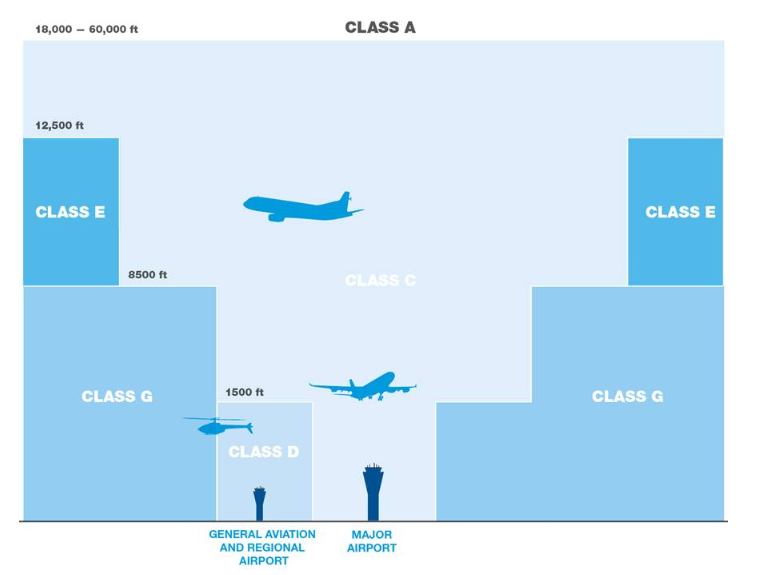
  • Controlled airspace which is actively managed by air traffic controllers and is broken up into a number of different classes or classifications. To enter controlled airspace, an aircraft must first gain a clearance from air traffic control.
  • Uncontrolled airspace which requires no clearance (or supervision by air traffic control) to operate. The large majority of light aircraft and helicopters operate outside or underneath controlled airspace (for example, aircraft that operate at low levels over Sydney Harbour).

Terminal Airspace

Terminal airspace is the controlled airspace surrounding a major airport, generally within a 30–50 nautical miles (55–90 kilometres) radius. In the case of some major airports, this airspace extends from ground level up to 18,000 feet (approximately 6,000 metres).

As the distance from the airport increases, the lower boundary of this airspace rises in steps, enabling other airspace users (such as gliders and balloons) to operate outside terminal airspace without requiring an air traffic clearance.

Restricted Airspace & No fly zones

In restricted airspace, aircraft movements are restricted in accordance with certain specified permissions. Examples of restricted airspace include airspace around military installations and high density flying operations at an air show or other large public event.

Restricted airspace may be imposed by police for safety or security reasons in the vicinity of bushfires or major crime scenes. Decisions on restricted airspace are made by the Civil Aviation Safety Authority.

No-fly zones are similar to restricted airspace but are imposed and enforced by the military (usually the Royal Australian Air Force). No-fly zones will often be established around military exercises, heads of government meetings and major events such as the Olympic or Commonwealth Games. Airservices has no authority or control over no-fly zones.

Find out more

Read more about our operations in our Guide to our operations booklet.

Controlled and uncontrolled airspace

There are two types of airspace — controlled and uncontrolled.

Controlled airspace

Airservices air traffic controllers manage controlled airspace. To enter controlled airspace, an aircraft must first gain a clearance from air traffic control. In controlled airspace all aircraft must have continual radio contact with air traffic control and submit a flight plan detailing the route and height they will fly. Some emergency operations do not have to submit a flight plan, due to the urgency of their flights.

Uncontrolled airspace

All other airspace is uncontrolled. No clearance is required to operate in uncontrolled airspace and there is no supervision by air traffic control. Pilots operating in uncontrolled airspace must still comply with aviation regulations. However, they do not need to submit a flight plan and they may only have partial radio contact. The large majority of light aircraft and helicopters operate mostly in uncontrolled airspace.

Find out more

Learn more about classes of Australia airspace

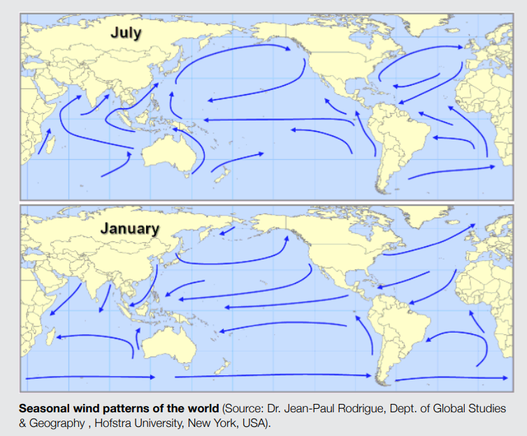
Seasonal weather patterns

Because aircraft must take off and land into the wind for safety reasons, the runway selected for use will be the one that allows “into-wind” operations. 

Wind patterns tend to be seasonal.  This means that at some times of the year a runway and its associated flight paths may receive more use than at other times of the year.

The following image outlines the seasonal wind patterns and how they vary around Australia.

Our fact sheet on Seasonal weather patterns explains this in more detail.

How our system calculates flights over an area

The following video explains how our system calculates location-specific data used on this website:

The NFPMS

We source data directly from the Airservices Noise and Flight Path Monitoring System. The largest monitoring system in the world, combining data from air traffic control systems with a network of monitors deployed in local communities.

By using the location you provided when you entered the website, we extract data collected by this system and combine this with geographically relevant information, tailoring the site.

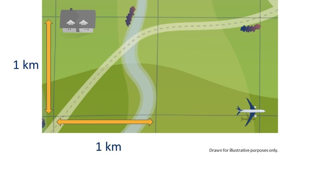
The grid

To be able to analyze the number of flights over your area, we have created a grid of identically sized, 1 kilometre by 1 kilometre squares. In total, the grid extends for 95 kilometres around each of the major airports in our coverage area. Initially this portal covers:

  • Adelaide
  • Brisbane
  • Cairns
  • Canberra
  • Gold Coast
  • Hobart
  • Melbourne
  • Perth
  • Sunshine Coast
  • Sydney

How we count the number of flights

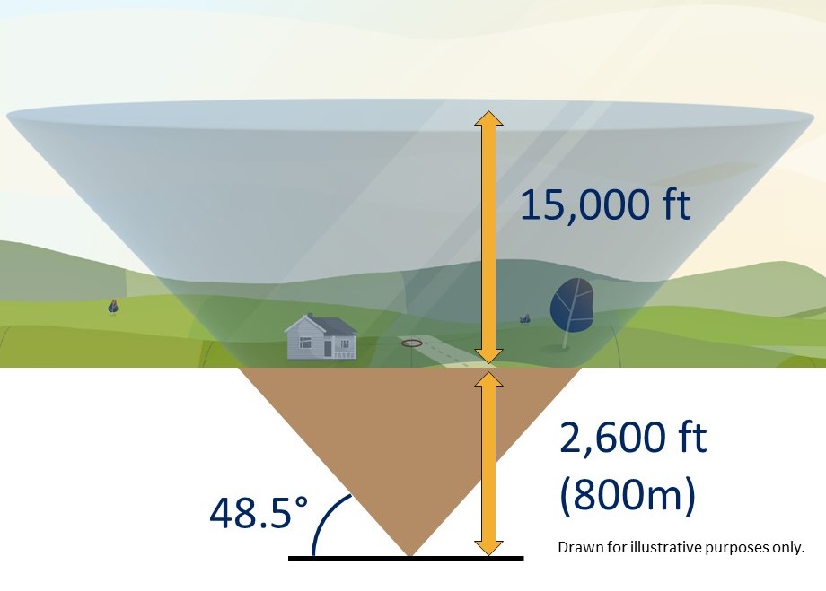
We start by drawing a cone at the centre of each grid. Using the location that you provided when you entered the site, we determine the nearest cone to you.

Flights that pass through each cone are recorded and that
data is presented on this website.

To avoid underestimating the flights in each area and to fully cover all locations in our grid, we lower the cone 2,600 feet (800 metres) into the ground.

The cone extends up to 15,000 feet (4.5 kilometres) above local ground level and at the very top, the cone is over 30,000 feet (9.4 kilometres) wide.

Why we use a cone

We use a cone because research undertaken by the United Kingdom Civil Aviation Authority identified that a cone best aligns with how we determine if an aircraft has overflown a location or not.

The 48.5-degree angle of the cone was selected as it incorporates an evaluation of noise, in that if one aircraft flew directly above the observer, followed by a second aircraft off to the side along the 48.5 degree line, the second aircraft would be 3 decibels quieter than the first.