How many aircraft fly near me?

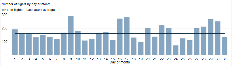
This tool shows the number of flights each day over your area in the selected month compared to the average for last year.  The bottom axis shows the day of the month. Use the drop-down menu to change the selected month to see how movements have varied. Hover over each day to see flight numbers.

*Please note due to technical issues between 19 June and 22 June 2024, flight data may not be accurately displayed. Our supplier is working to resolve the issue. We apologise for any inconvenience this may cause.

How frequent are flights in my area?

There are a number of factors that influence the frequency of flights.

Firstly, the number and frequency of flights will vary on a daily, weekly and yearly basis due to differences in airline schedules. The airlines schedule flights in response to consumer demand. This is particularly the case around Christmas, Easter, school holidays and Lunar New Year.

Secondly, the runway in use at any given time will also vary, largely due to the wind conditions. Each runway has its own set of flight paths, and each flight path will affect different areas. As the runway in use changes, the flight paths change, and so too do the areas affected by aircraft movements.

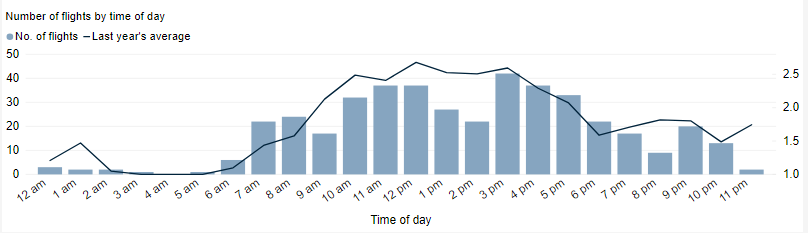
This chart shows the total number of flights each hour over the month, compared to the average for last year. Change the selected month to see how it has varied.

*Please note due to technical issues between 19 June and 22 June 2024, flight data may not be accurately displayed. Our supplier is working to resolve the issue. We apologise for any inconvenience this may cause.

How high are aircraft near me?

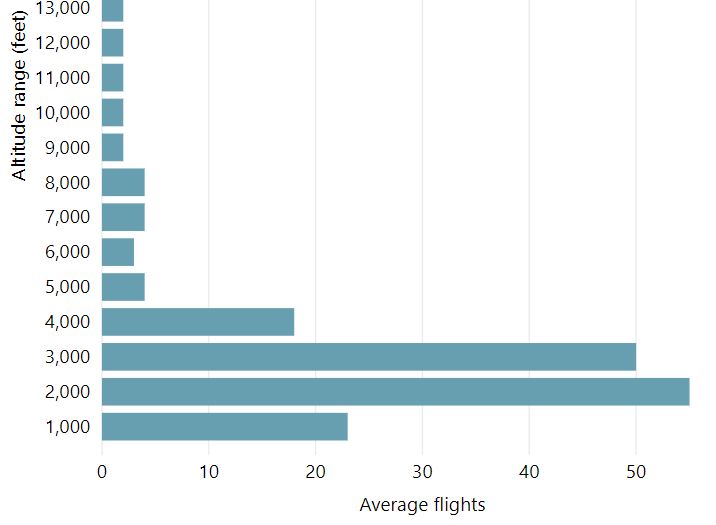
The altitudes of aircraft over your area can vary according to:

  • the airport the flight is coming from or going to
  • whether the aircraft is arriving, departing or in level flight
  • the specific requirements of the flight path
  • the need for air traffic control to maintain vertical separation between aircraft.

Find out more on our What are the rules about altitudes? page.

*Please note due to technical issues between 19 June and 22 June 2024, flight data may not be accurately displayed. Our supplier is working to resolve the issue. We apologise for any inconvenience this may cause.

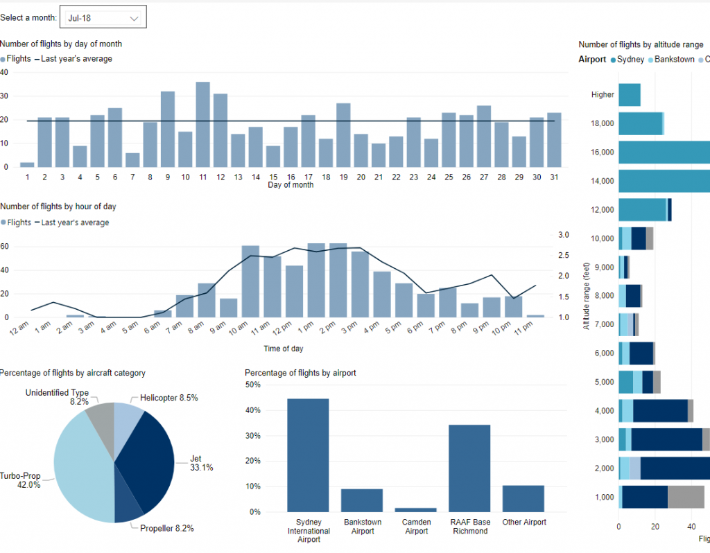
Explore detailed data for your area

Use this interactive tool to explore detailed data for your suburb in the month of your choice.

This report is best viewed in full screen mode.

*Please note due to technical issues between 19 June and 22 June 2024, flight data may not be accurately displayed. Our supplier is working to resolve the issue. We apologise for any inconvenience this may cause.

Western Sydney noise monitoring report

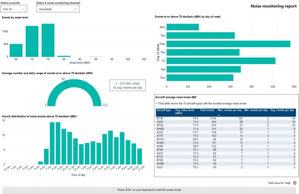
As part of the Western Sydney Noise and Flight Path Monitoring System (NFPMS), Airservices monitors noise levels in areas surrounding Western Sydney Airport using 13 noise monitors . We strategically deploy noise monitors at various locations around the Western Sydney region to capture data from aircraft operations in differing phases of flight.

Noise monitor data is publicly available on WebTrak, for community members to see the noise level of aircraft as they pass over the monitors. WebTrak uses official aircraft movement data and is designed as both a flight tracking and noise monitoring tool. To ensure aircraft track information and noise monitoring data are accurately processed and synchronised, the system applies a three-minute delay before information is displayed. This processing period improves data quality and helps minimise gaps that may occur because of communications or data transfer delays. The below interactive tool provides a monthly report for each long-term noise monitor.

Please note that the monthly noise monitoring report includes only aircraft movements associated with Western Sydney Airport (WSI). The accompanying graphs display only WSI-related noise events exceeding 65 dBA.

The tool is best viewed in full screen mode. To familiarise yourself with the tool, we advise that you click on the ‘Click here for Help’ button on the bottom right of the tool before use.