Will flights increase in the future in my area?

Flight Path and Airspace Changes

Visit Engage Airservices to engage with our program of flight path and airspace changes.

Airport Master Plans

Airport Master Plans provide a blueprint for the future development of an airport over a twenty year period. They include information on forecast growth, airport terminals and facilities, runways and flight paths.

Who is responsible for master planning?

Airports are responsible for producing the master plan, while the overall process is administered and regulated by the Department of Infrastructure, Transport, Regional Development, Communications, Sport and the Arts

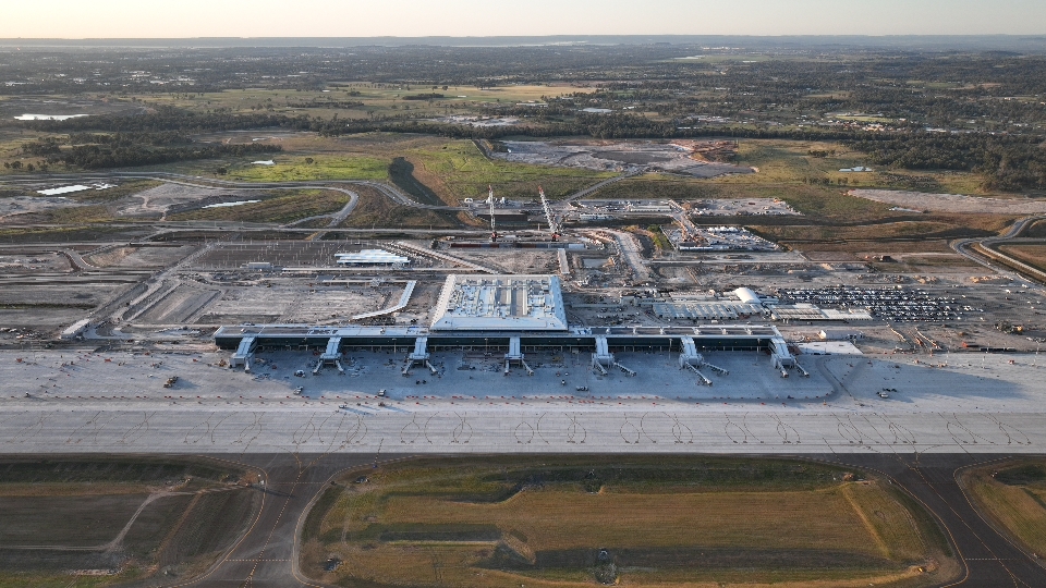
Western Sydney Airport

The Western Sydney Airport Master Plan can be found on the Western Sydney Airport website.

Unusual activity

We regularly receive calls about unusual or irregular aircraft activity or airport operations.

Aircraft may not fly on the published flight path for a number of reasons. You can learn more on our Do planes have to stay on flight paths? page.

Some other common reasons we are contacted are:

Circuit Training

At major general aviation airports around the country including Bankstown (NSW), Archerfield (QLD), Moorabbin (VIC), Parafield (SA) and Jandakot (WA), flight training schools regularly conduct circuit training. Circuit training sees aircraft, usually small single engine propeller aircraft, fly over the surrounding suburbs at a height of approximately 1,000 ft (305 metres).

Low level flights

Occasionally, aircraft and helicopters fly at low levels for reasons including law enforcement, rescue and military operations, aerobatic or air show displays.

More information is available on our What are the rules about helicopters? page and What are the rules about altitudes? page.

Equipment testing & calibration

We are responsible for conducting regular flight calibration inspections on around 500 navigational aids nationwide.

This involves a specially equipped aircraft conducting numerous ‘missed approaches’ to test and calibrate equipment usually at low level. In order to fully check the equipment several passes are required, and the aircraft may remain in the area for an extended period of time.

Whilst we take measures to reduce the impact of these inspections, they are required to maintain safety of the entire aviation system and on occasion we may need to undertake these at sensitive times.

Smoke and flames from an airport

We regularly conduct training exercises around the country for aviation fire fighters which involve the creation of large amounts of smoke and flames. There may also be an unusually high number of emergency vehicle movements. The appearance of smoke and flames at an airport does not mean there has been an accident or that there is any concern for aircraft safety.

Why does the amount of light aircraft and helicopter traffic vary?

The amount of light aircraft and helicopters flying at any given time will vary subject to multiple factors including air traffic control clearances.

Weather

Helicopters and light aircraft often fly Visual Flight Rules (VFR) where the pilot uses visual references to the ground or water and does not fly on a set flight path. This means that when the weather is poor, for example when low cloud or fog hampers visibility, these aircraft cannot fly and you will notice a significant drop in the amount of this type of traffic.

Weekends and holidays

Pilots who fly solely for their own recreation generally have weekday jobs and therefore will fly on weekends and holidays when the weather is good. This can contribute to an increase in light aircraft traffic on weekends and some holiday periods.

Time of day

As most recreational pilots are not licensed to fly at night, recreational traffic generally ceases at sunset.

Flying courses

Flying courses have a number of different stages in which students cover theory, then begin circuit training and then progress to flying to training areas and other locations with their instructor. Some courses include night flying training. As students progress through these different stages you may notice variation in the frequency and/or location of light aircraft and helicopter traffic. During periods in-between courses, or during holiday breaks within courses, you may notice a drop in traffic.

Western Sydney Airport flight paths

Western Sydney Airport has a one runway, oriented north-east/south-west.

Generally, aircraft land and take-off into the wind. Therefore, the prevailing wind conditions influence which runway direction is being used at any time during the day and evening. When Runway 05 is used, all aircraft arrive from the south-west and depart to the north-east. When Runway 23 is used, all aircraft arrive from the north-east and depart to the south-west. When Reciprocal Runway Operations (RRO) is in use, aircraft depart to the south-west and aircraft arrive from the south-west.

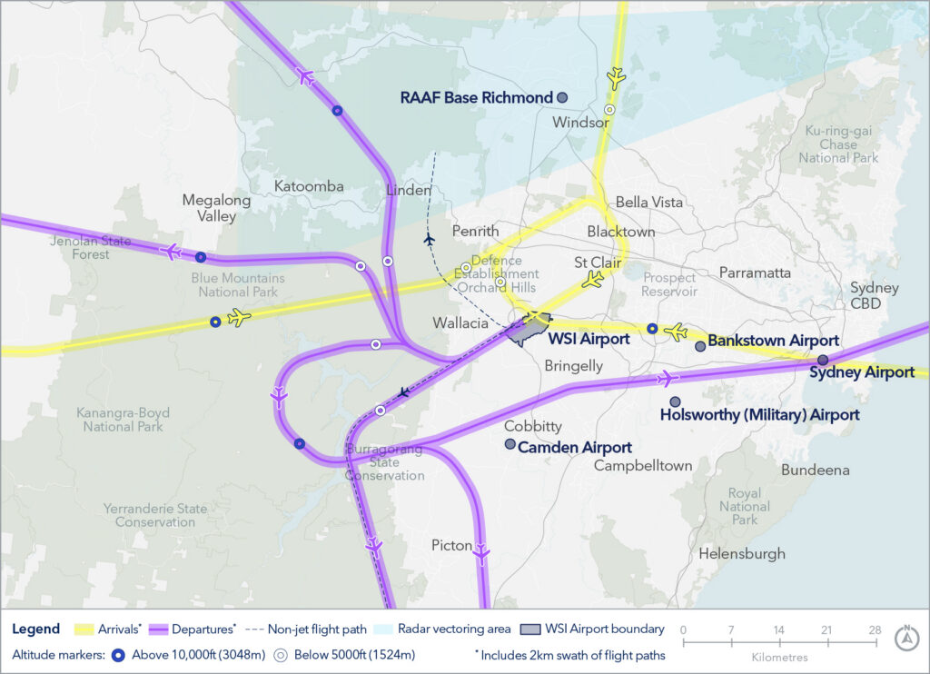
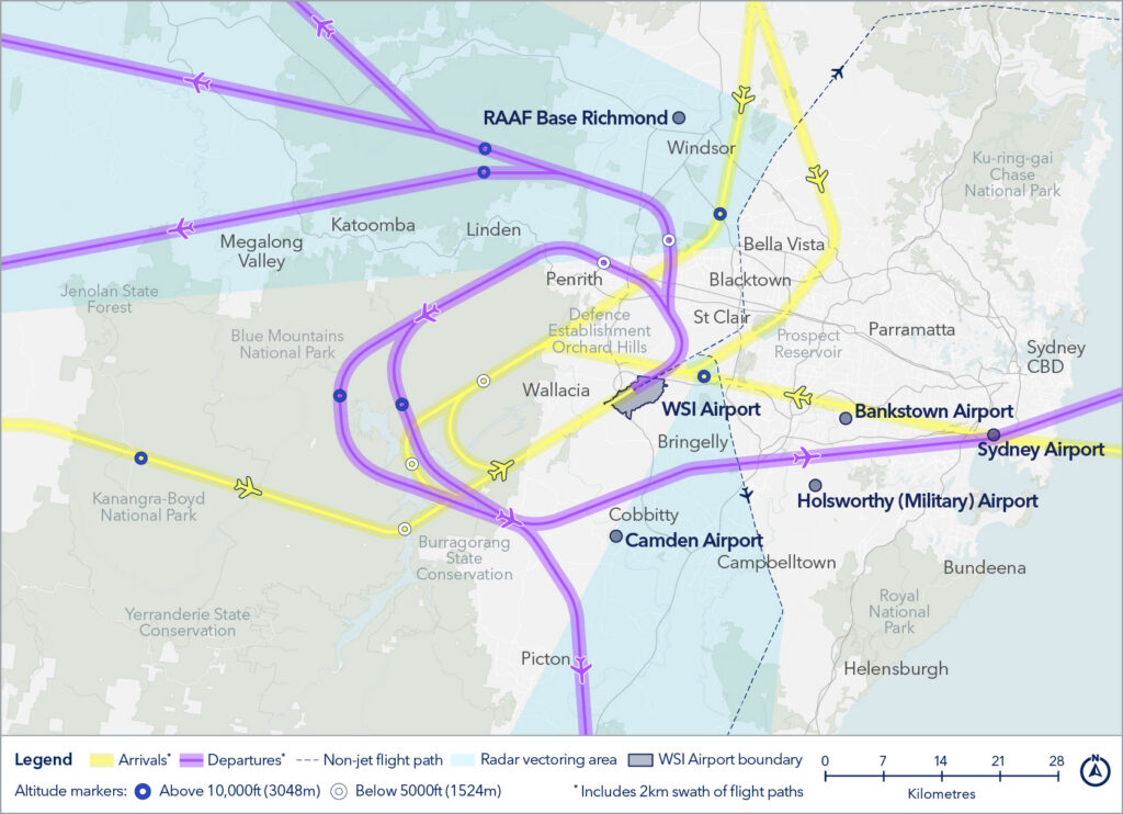
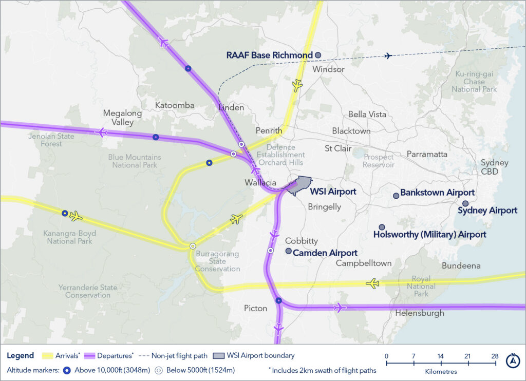
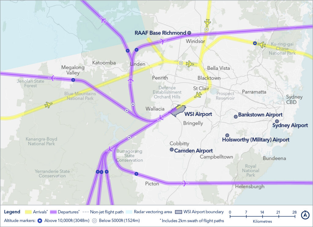
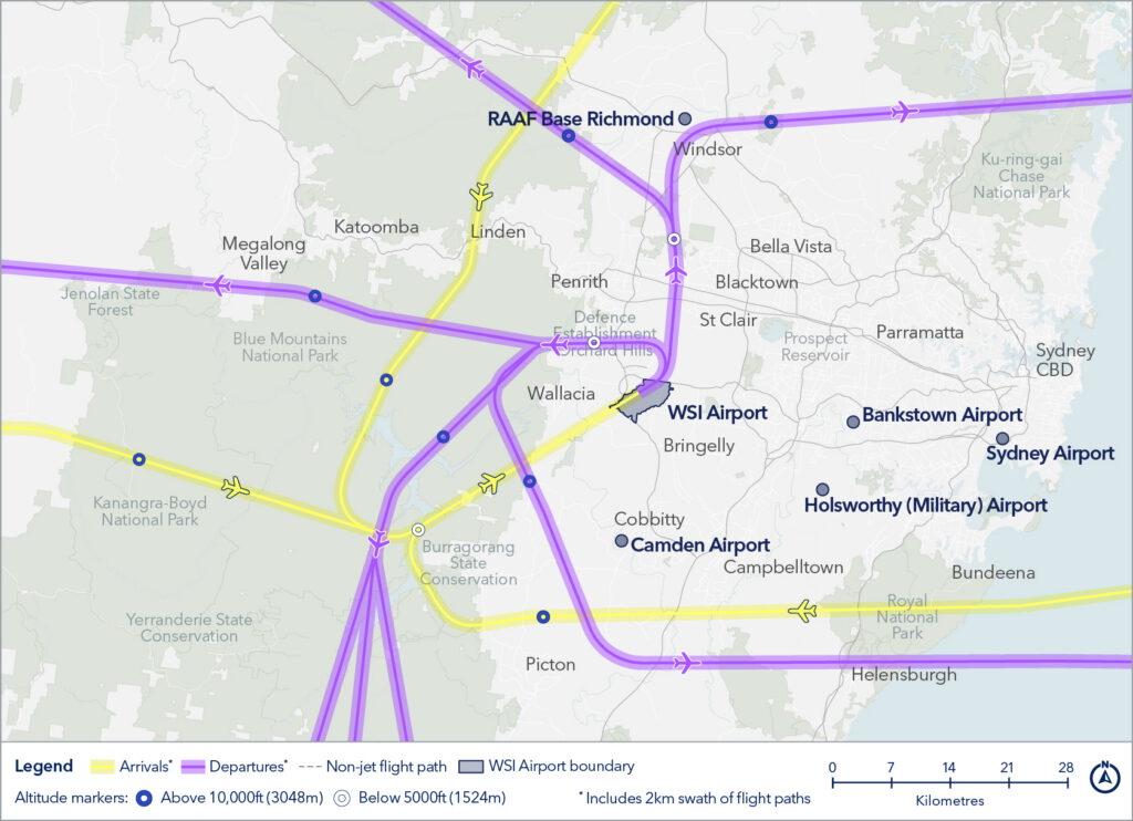
There are five different modes that the runway can be used in. There are different flight paths associated with the different runway modes. Maps showing these flight paths are shown below.

During the day time period (5:30am-11pm), there are two runway modes available:

  • Runway 23 (day)
  • Runway 05 (day)

Runway 23 (day)
Departing aircraft (in purple) take-off from Runway 23 in a south-westerly direction. Arriving aircraft (in yellow) land on Runway 23 approaching from the north-east.

Runway 05 (day)
Departing aircraft (in purple) take-off from Runway 05 in a North-easterly direction. Arriving aircraft (in yellow) land on Runway 23 approaching from the south-east.

During the overnight period (11pm to 5:30am), there are three runway modes available:

  • Reciprocal Runway Operations (RRO)
  • Runway 23 (night)
  • Runway 05 (night)

Reciprocal Runway Operations (RRO)
Aircraft depart to the south-west (in purple) and aircraft arrive from the south-west (in yellow)

RRO is only available overnight and can only be used when very specific weather and traffic conditions are met. More information about RRO can be found in the factsheet here.

Runway 23 (night)
Departing aircraft (in purple) take-off from Runway 23 in a south-westerly direction. Arriving aircraft (in yellow) land on Runway 23 approaching from the north-east.

Runway 05 (night)
Departing aircraft (in purple) take-off from Runway 05 in a North-easterly direction. Arriving aircraft (in yellow) land on Runway 23 approaching from the south-east.

When is each flight path used?

Generally, aircraft land and take-off into the wind. Therefore, the prevailing wind conditions influence which runway direction is being used at any time during the day and evening. When Runway 05 is used, all aircraft arrive from the south-west and depart to the north-east. When Runway 23 is used, all aircraft arrive from the north-east and depart to the south-west.

During the day and evening (5.30am to 11pm), arrival and departure paths are designed to ensure separation from arriving and departing aircraft from Sydney Kingsford-Smith Airport (Sydney Airport).

At night (11pm to 5.30am), when additional airspace flexibility is available because of the curfew at Sydney Airport noise preferential flight paths are used to direct aircraft away from residential areas, where possible. The use of night runway operating modes at WSI is dependent on transition to and from Sydney Airport curfew, so this means there may be variations from day to day to accommodate these transitions.

Departures

Departing aircraft will initially follow the runway heading after take-off. Once they have reached the appropriate altitude and air traffic control clearance, they will then turn onto their designated flight paths and continue toward their destination.

Depending on the runway mode in use, residents in suburbs located to the south-west and north-east of the runway centreline may notice aircraft overhead shortly after take-off. These aircraft will generally be climbing and following the runway heading before commencing any turns onto their assigned departure routes. This means that the areas experiencing departing aircraft can vary depending on which runway configuration is being used on the day.

The altitude of aircraft after departure will depend on factors such as the type of aircraft, how heavily laden it is with fuel and passengers, and the atmospheric conditions at the time. All these factors affect an aircraft’s climb rate. There is no regulated minimum altitude for an aircraft in the process of taking off.

Arrivals

Aircraft arriving at the airport will generally follow their designated flight paths as they approach the runway. As they get closer to the airport, aircraft will align with the runway centreline and continue straight ahead for landing.

Depending on the runway mode in use, residents in suburbs located to the south-west and north-east of the runway centreline may notice aircraft overhead during the final stages of their approach. These aircraft will typically be descending and aligning with the runway in preparation for landing. As a result, the areas experiencing arriving aircraft can vary depending on which runway configuration is being used on the day. The altitude of an aircraft when it begins its final approach will depend on how far it still has to fly before reaching the runway.

Flight path information

You can access historical information about flight path use through WebTrak. To access this information click the “Historical” link below the text in the Quick Start Guide at the top left-hand side of the screen. Then use the tick boxes at the bottom-right of the screen to select monthly, quarterly or yearly information. Use the sliders to refine your selection to specific timeframes.

Noise Complaints and Information Service Report

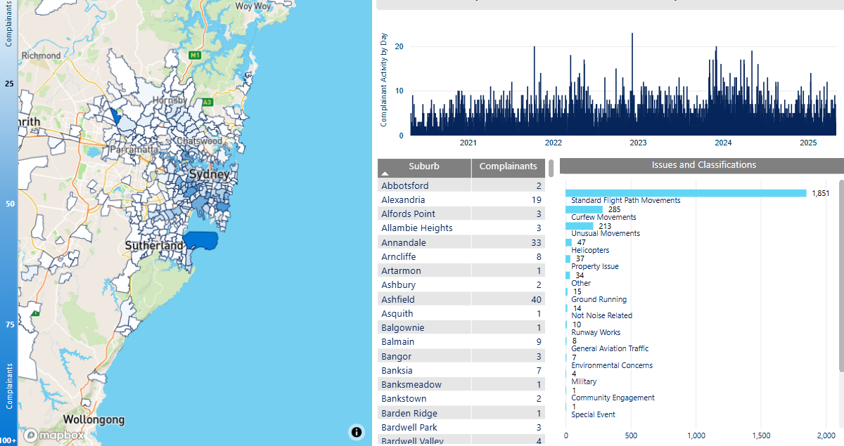
We manage complaints and enquiries about aircraft noise and operations through our Noise Complaints and Information Service (NCIS). The information below is collected for the purpose of complaint management, analysis of issues and identification of causal factors.

For this reason we refer to ‘complainants’ and ‘issues’. Complainants are people who contacted us. While some people submitted enquiries or comments rather than complaints, all are referred to as “complainants”. Issues are the primary concern they raised.

The complaints report

Use this interactive tool to explore the issues raised by residents from different suburbs. For help, click the button in the bottom right-hand corner.

Please note that complaints data is available from July 2026 onwards. For complaints information prior to July 2026 for airports other than WSI, please visit the relevant Aircraft in Your Neighbourhood (AIYN) page.

This report is best viewed in full screen mode.