Learn about flight paths and aircraft movements in your area
Welcome to the Aircraft in Your Neighborhood Portal
Our goal is that you will learn more about the flight paths and aircraft movements in your area and be able to access the information and resources that explain how air traffic is managed.
First, please select your location using one of the following options, so that we can customize the information for your location.
We’ll remember your location so you don’t have to enter it every time you visit the site and we’ll keep this information confidential.
Please note, that this site works best on Chrome, Firefox and Edge.
* Mandatory - Select region first to view the map.
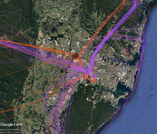
There are a number of routes around Sydney used by light aircraft and helicopters.
It is not mandatory that light aircraft and helicopters fly on these routes. As you will see from the images below which show the tracks of actual flights, some aircraft may fly the whole route but others may only fly part of it, joining or leaving it depending on their purpose or destination. Other aircraft may not use the routes at all.
These routes are mainly outside controlled airspace (“OCTA”), that is, aircraft are not being directed by air traffic control. Whenever they fly outside controlled airspace, pilots are following the rules of the air. Our booklet, Guide to our Operations, explains more about different types of airspace.
Pilots using these routes are usually flying under Visual Flight Rules, which means they navigate using landmarks that are easily seen from the air. This does not mean they must fly over each landmark; rather, they use each landmark to be sure of their position.
Most of these routes lead to and from Bankstown Airport, as shown in the images above and below.
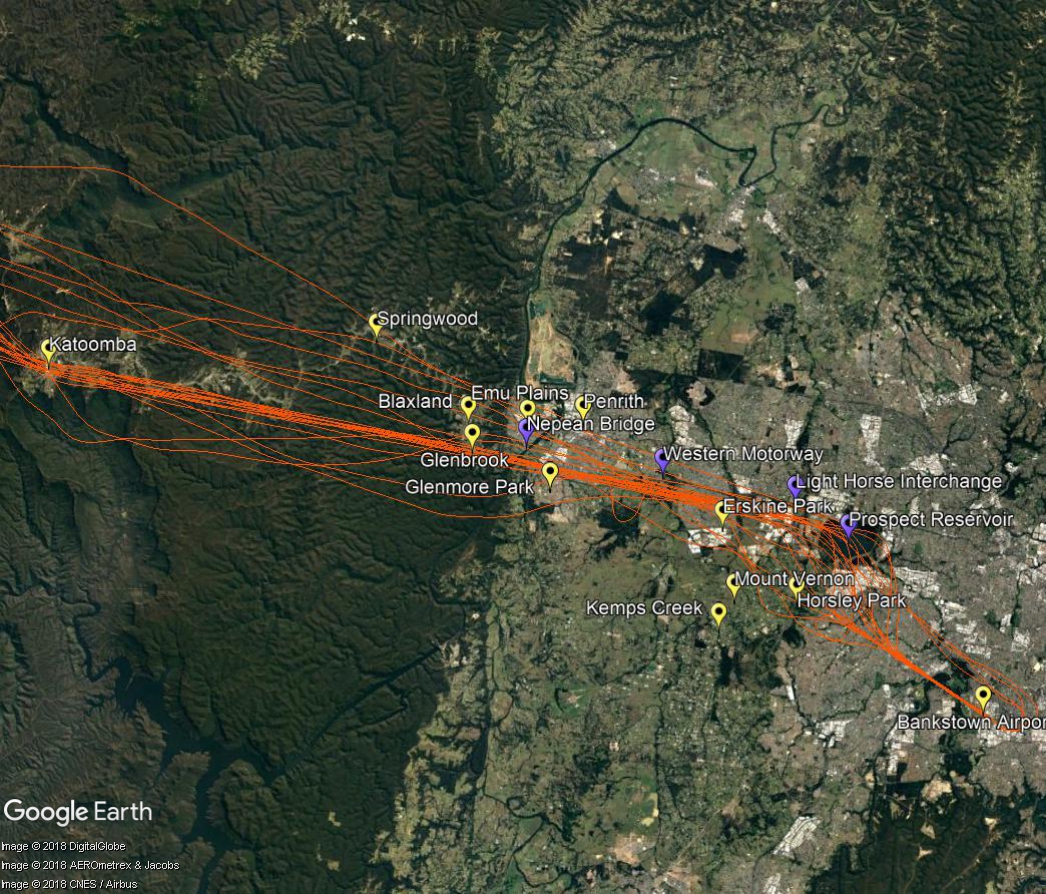
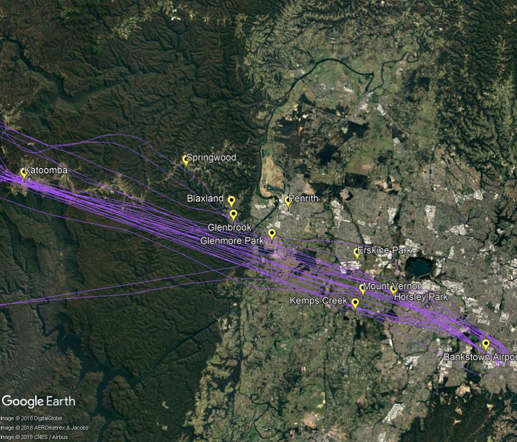
Inbound from west
Light aircraft and helicopters inbound from the west to Bankstown Airport navigate using the Great Western Highway, Nepean Bridge, Western Motorway, Light Horse Interchange and Prospect Reservoir. Pilots will usually follow the Great Western Highway over the Blue Mountains to ensure they do not stray into the restricted military airspace around Richmond RAAF Base which is located immediately to the north.
Outbound to west
When flying outbound to the west, aircraft must avoid the Richmond RAAF Base military area and will use the towns of Penrith, Glenbrook, Springwood and Katoomba as visual aids to avoid tracking into restricted airspace.
Aircraft may climb to 2,500 feet once they have passed the Liverpool to Parramatta railway line. Once west of Glenbrook aircraft may fly up to 6500 feet.
Aircraft that fly over the Blue Mountains from Sydney Airport depart from the westernmost of the parallel runways and turn towards the north-west. They are tracking towards a waypoint located over Katoomba. A waypoint is a set of co-ordinates in the air. This waypoint replaces a non-directional beacon which was a ground-based navigational aid that had been in this location since the 1950s.
Departure flight paths are organised so as to efficiently move aircraft onto their routes. The flight path that passes over the Blue Mountains is assigned to aircraft that are heading for destinations to the west, north and north-west such as Dubbo, Perth, Adelaide, Darwin, Broome, Singapore, Kuala Lumpur, Dubai, Abu Dhabi, Hong Kong and Shanghai, for example.
While this is not a new flight path, advances in navigation technology used by modern aircraft mean that aircraft are now able to fly flight paths more precisely and this has resulted in increased concentration of flight paths over the years, including this one.
Altitudes
The altitudes of traffic departing Sydney Airport will vary according to which runway the aircraft has departed from because this affects the number of track miles the aircraft has flown before it reaches the Blue Mountains. The more track miles flown, the more time the aircraft has had to increase altitude and the higher it will be over your area.
Altitudes will also vary according to other factors such as the weight of the aircraft and how heavily laden it is. For example, long-haul aircraft departing for Dubai will be much heavier than smaller aircraft heading to Perth or Adelaide due to fuel load and aircraft size and these differences in weight alone will affect an aircraft’s climb rate.
Even the atmospheric conditions at the time can play a part. When the weather is warm, the air is less dense and therefore there is less lift and the aircraft climbs more slowly. Due to these variable factors the altitudes quoted below are not limits and some aircraft may be higher and some lower that the ranges given.
Jet aircraft departing towards the north will generally be within the altitude range of 10,000 to 20,000 feet. Turbo-prop aircraft that have departed Sydney Airport may range from 7,000 to 15,000 feet.
For aircraft departing towards the south, jets will generally be from 15,000 to 25,000 feet. Turbo-prop aircraft will usually be from 10,000 to 15,000 feet.
Many Blue Mountains residents have told us they feel jet aircraft are lower now than in the past. We conducted an investigation into this question, looking at altitudes of aircraft that passed within a five kilometre radius of Blaxland in January of each year from 2012 to 2018. The investigation found variation in altitudes between different aircraft types but relatively little variation within the same aircraft type. The variation in altitudes between aircraft types can be attributed largely to the differing maximum take-off weight of each type. Heavier jets demonstrated a poorer climb performance than lighter jets.
The investigation also found a marked increase in airlines using A380-800 aircraft – from 23 flights in January 2012 to 126 flights in January 2018. As the A380 is the heaviest jet and as the study indicated that they have the lowest average altitude, the increased use of this aircraft type is likely to be a major contributing factor to the community’s perception that altitudes over Blaxland have decreased.
Prospects for change
Airservices has investigated whether it would be feasible to move the Katoomba waypoint. The investigation found that this would adversely impact on safety and would not be operationally feasible due to the constraints of military airspace restrictions and air traffic control sector boundary and route segregation requirements. It would also negatively impact on communities closer to Sydney Airport where the noise levels would be higher than those currently experienced in the Blue Mountains.
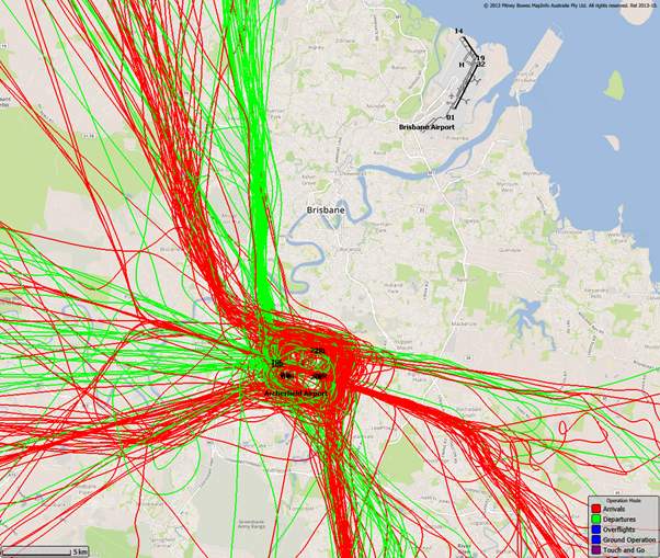
The airspace surrounding Brisbane Airport is controlled from the ground level up. The base of the controlled airspace rises moving outwards from Brisbane Airport, with the airspace below the base being uncontrolled. Light aircraft and helicopters often remain in uncontrolled airspace to remain separated from large passenger aircraft that transit through controlled airspace.
The following image shows light aircraft and helicopter movements in uncontrolled airspace throughout the Brisbane region. As you can see, these flights remain clear of Brisbane Airport:
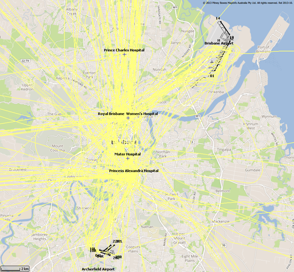
This however does not mean light aircraft and helicopters are restricted from entering controlled airspace. In order to access this airspace, the aircraft operator requires an airspace clearance and is obligated to abide by air traffic control directions once in the controlled airspace. In the Brisbane region, the most common user of this airspace apart from Brisbane Airport traffic is medical helicopters flying to and from local hospitals. The following image shows some of these flights:
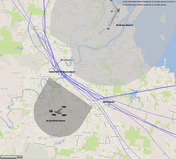
Archerfield Airport also has a pocket of controlled airspace surrounding the airport. A difference to Brisbane’s controlled airspace though is that Archerfield’s is only active from 7:00am – 5:00pm. Outside of these hours the airspace around Archerfield is uncontrolled.
In busy airspace where there is a mix of controlled and uncontrolled airspace, lanes are often established to ensure pilots transiting through the airspace remain outside of controlled airspace. One such lane passes between Brisbane’s and Archerfield’s control zones. The following image shows aircraft using this lane. The control zones for Brisbane Airport and Archerfield Airport are shaded grey. Pilots navigating along these lanes do so with visual reference to landmarks that are easy to recognise from the air which in this case is the University of Queensland and the brickworks in Rochedale. Both of this places are referenced on the map:
There are a number of routes around Sydney used by light aircraft and helicopters.
It is not mandatory that light aircraft and helicopters fly on these routes. As you will see from the images below which show the tracks of actual flights, some aircraft may fly the whole route but others may only fly part of it, joining or leaving it depending on their purpose or destination. Other aircraft may not use the routes at all.
These routes are mainly outside controlled airspace (“OCTA”), that is, aircraft are not being directed by air traffic control. Whenever they fly outside controlled airspace, pilots are following the rules of the air. Our booklet, Guide to our Operations, explains more about different types of airspace.
Pilots using these routes are usually flying under Visual Flight Rules, which means they navigate using landmarks that are easily seen from the air. This does not mean they must fly over each landmark; rather, they use each landmark to be sure of their position.
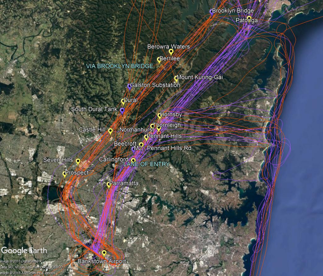
Most of these routes lead to and from Bankstown Airport, as shown in the images above and below.
To and from the north
The two northern routes are shown in the image below. One is via Brooklyn Bridge, the Galston electricity substation, the water tank at South Dural and Prospect Reservoir.
The other route is a designated “lane of entry” that allows aircraft to come and go from Bankstown Airport without entering the controlled airspace of Sydney Airport or Richmond RAAF Base. It is also used by aircraft transiting from north of Sydney to areas south and south west of the city. This corridor of airspace has a ceiling height of 2,000 to 2,500 feet.
The lane of entry runs between Bankstown Airport and Patonga. Outbound aircraft head to Parramatta and past the Prospect to Potts Hill pipeline. Once north of the pipeline aircraft can climb to 2,000 feet. Tracking features include the intersection of the M2 and Pennant Hills Road, the strobe light at Pennant Hills CBD, a covered reservoir at Thornleigh and the Hornsby CBD and railway sheds. The track then follows the eastern side of the M1 motorway (Sydney Newcastle Freeway) and onwards to Patonga.
Aircraft may turn east from the lane at Hornsby and travel towards the coast using the Baha’i Temple as a tracking feature. Once at the coast aircraft may track to Long Reef or conduct a harbour scenic flight or coastal flight.
In the image below the tracks of inbound aircraft are shown in orange and outbound are purple.
Visit Engage Airservices to engage with our program of flight path and airspace changes.
Hobart Airspace Design Review – Post Implementation Review
On 7 November 2019, Airservices introduced new instrument flight procedures and flight paths at Hobart Airport. As these flight paths have been in operation for over 12 months, we have commenced a Post Implementation Review (PIR) and are accepting community suggested alternatives for flight paths and Noise Abatement Procedures (NAPS).
For more information, including how to participate in the Review visit Engage Airservices.
Airport Master Plans
Airport Master Plans provide a blueprint for the future development of an airport over a twenty year period. They include information on forecast growth, airport terminals and facilities, runways and flight paths.
Who is responsible for master planning?
Airports are responsible for producing the master plan.
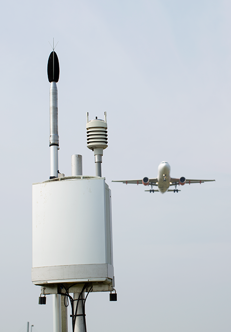
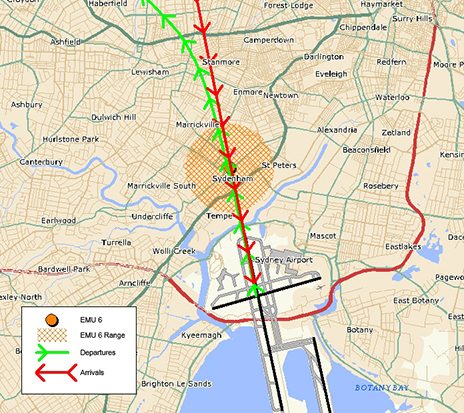
We collect noise and operational data from twelve noise monitors (Environmental Monitoring Unit, EMU) around Sydney Airport. Noise monitors are listed below according to their location.
Captures arrivals to Runway 16 Right and departures off Runway 34 Left. This monitor is closest to the threshold of Runway 16 Right/34 Left. The consistently high number of noise events reflects the high use of the main runway throughout the year.
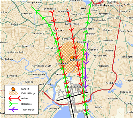
EMU 13 (St Peters)
St Peters (EMU 13)
Main purpose is to capture arrivals to Runway 16 Left, however it can capture movements from Runway 16 Right/34 Left and departures off Runway 34 Right.
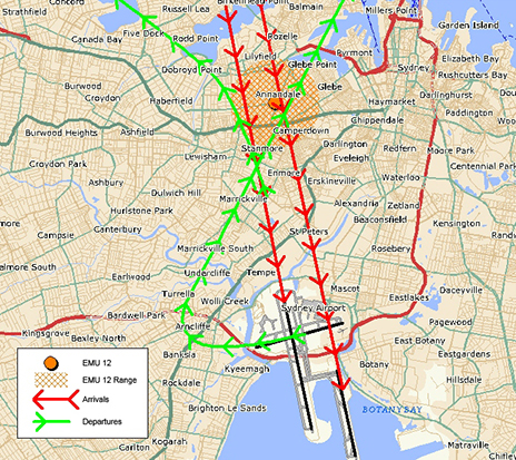
This monitor captures many of the same operations as the Annandale monitor and demonstrates the same seasonal pattern. However, being closer to the runway it captures more aircraft noise events.
EMU 12 (Annandale)
Annandale (EMU 12)
Main purpose is to capture arrivals to Runway 16 Left, however it can also capture movements from Runway 16 Right/34 Left and departures off Runway 34 Right.
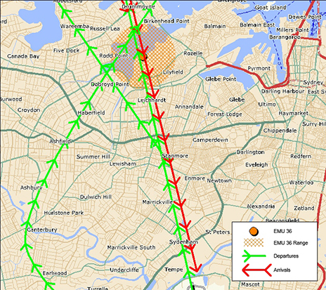
The pattern of aircraft noise events recorded at this monitor reflects the seasonal pattern use of Runway 16 Right, with generally more events recorded in summer than in winter.
EMU 36 (Leichhardt)
Leichhardt (EMU 36)
Captures arrivals to Runway 16 Right.
This monitor is affected by the same operations as Hunters Hill monitor and reflects the seasonal pattern use of Runway 16 Right, with more events captured in summer than in winter.
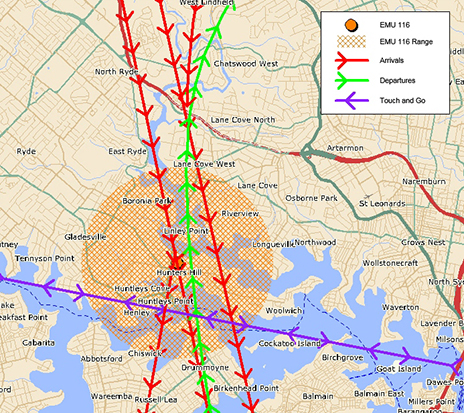
EMU 116 (Hunters Hill)
Hunters Hill (EMU 116)
Captures arrivals to Runway 16 Right.
The number of noise events recorded by this monitor reflects the seasonal pattern use of Runway 16 Right, with more events captured in summer than in winter.
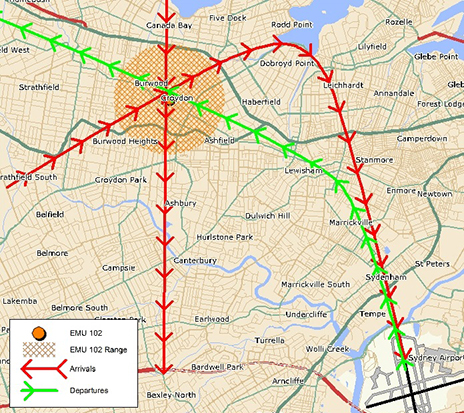
EMU 102 (Croydon)
Croydon (EMU 102)
Captures departures off Runway 34 Left.
The number of noise events recorded reflects the seasonal pattern use of Runway 34 Left with more aircraft noise events captured in winter than in summer.
Southern Monitors
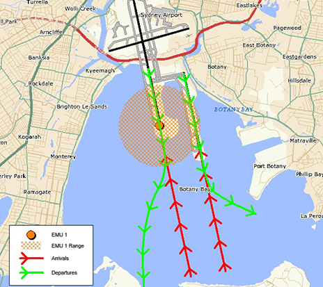
EMU 1 (Threshold Runway 34)
Threshold Runway 34 (EMU 1)
Captures departures off Runways 16 Right and 16 Left and arrivals to Runways 34 Left and 34 Right
The number of aircraft noise events captured reflects the pattern of use of Runway 34 Left, with more events generally recorded in winter than in summer.
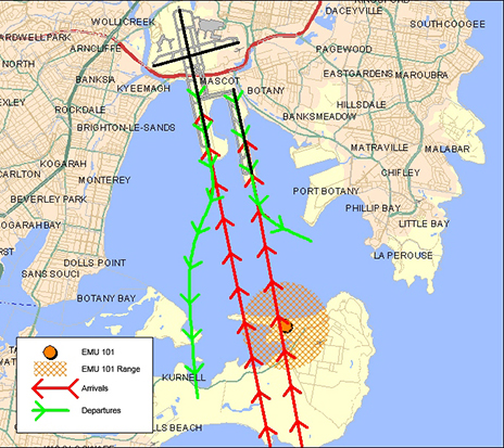
EMU 101 (Kurnell)
Kurnell (EMU 101)
Captures arrivals to Runway 34 Right and some arrivals to Runway 34 Left
Eastern Monitors
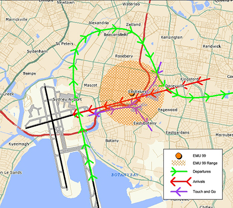
EMU 99 (Eastlakes)
Eastlakes (EMU 99)
Captures arrivals to Runway 25 and departures off Runway 07 and Runway 34 Right.
The pattern of aircraft noise events recorded reflects the seasonal use of Runway 34 Right, with more movements in winter than in summer.
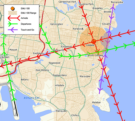
EMU 100 (Coogee)
Coogee (EMU 100)
Captures arrivals to Runway 25, departures off Runway 07 and Runway 34R heading to the east and south.
Captures noise from similar operations and reflects the same seasonal pattern to the Eastlakes monitor, however being further east from the airport the number of noise events recorded is smaller.
Western Monitors
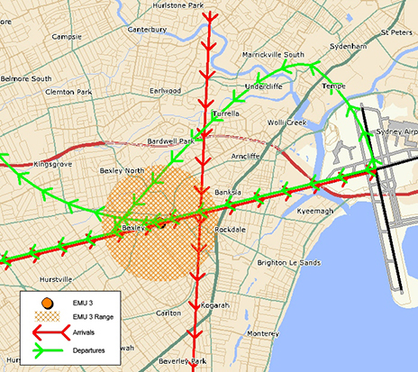
EMU 3 (Bexley)
Bexley (EMU 3)
Captures arrivals to Runway 07 and departures off Runway 25.
This monitor is closer to the runway than the Penshurst monitor, therefore it displays the same trends but records more aircraft noise events.
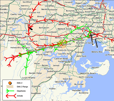
EMU 2 Penshurst
Penshurst (EMU 2)
Captures arrivals to Runway 07 and departures off Runway 25.
Historically at Sydney Airport there are fewer departures off Runway 25 than the other Runways.
We have assembled a list of our commonly asked questions that are asked in most areas.
Why can aircraft fly at sensitive times?
Aviation is a vital industry for the Australian economy. Business, tourism, social and freight activities rely on aviation. Unlike many other industries, aviation is regulated by the federal government rather than by state governments. This makes aircraft noise regulation quite different from the type of noise regulation you are used to at a local level that might, for example, prohibit noisy activities before 8:00 am on a Sunday.
Major airports in Australia are situated very close to residential areas and for this reason it is not possible to design flight paths that avoid flying over homes. In cities where the airport is located on the coast, flight paths will be designed to fly over water wherever possible. However because aircraft must take off and land into the wind, it is not always possible to avoid flying over residential suburbs by staying over water.
Aircraft noise remains a key challenge for an industry that is forecasting high levels of growth in air traffic movements over the next 20 years. Managing noise impacts on communities requires careful balance between the protection of affected residents and recognition of the broader economic and social contributions of the aviation activity.
Why can’t the flight paths be moved away from me?
Flight path design is a complex process. Flight paths must comply with international design standards and Australian safety regulations. Changes to flight paths may be made for a variety of reasons, including safety and noise management. However, changes are not easy to make as changes to one flight path usually impact other flight paths.
In considering any change, first of all we must have regard to safety – any change that could compromise safety cannot be progressed. Managing aircraft in a regular way and minimising complexities are central tenets of safety. We also consider the efficient operations of the airport and whether there would be an overall noise improvement for the community. We do not generally consider that moving noise from one part of the community to another is a noise improvement. In considering this we have to have regard to the entire flight path and the fact that moving it at one point may result in adverse effects many kilometres away. Unfortunately, the reality is that it is very difficult to identify flight path changes in metropolitan areas that can be made without moving the noise, or compromising safety or efficiency.
If a potential change is identified it must be environmentally assessed, the community, including potentially affected areas, the airlines and other stakeholders must be consulted and feedback from all must be considered. Finally, if the change is to go ahead, aeronautical documents for pilots must be produced and published and time allowed for crews and air traffic controllers to be trained in the new procedures. All these requirements mean that changes can take several years to make.
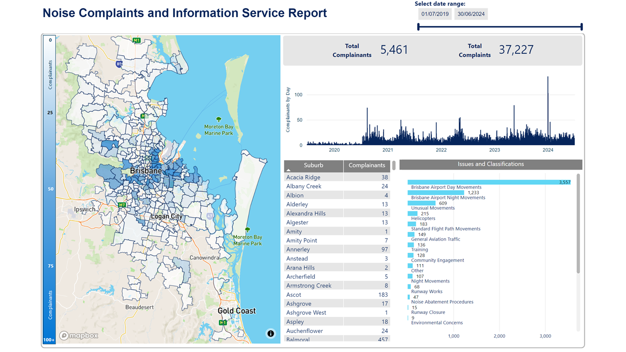
We manage complaints and enquiries about aircraft noise and operations through our Noise Complaints and Information Service (NCIS). The information below is collected for the purpose of complaint management, analysis of issues and identification of causal factors.
For this reason we refer to ‘complainants’ and ‘issues’. Complainants are people who contacted us. While some people submitted enquiries or comments rather than complaints, all are referred to as “complainants”. Issues are the primary concern they raised.
The complaints report
Use this interactive tool to explore the issues raised by residents from different suburbs. For help, click the button in the bottom right-hand corner.
An Instrument Landing System (ILS) is a navigational aid that emits radio signals to provide vertical and horizontal guidance to pilots landing in low-visibility and inclement weather conditions. This type of system requires a flight path that extends in a straight line from the runway.
Airports without an ILS can experience higher levels of missed approaches, unstable approaches and in some cases, diversions to alternate airports when safe landing is not possible.
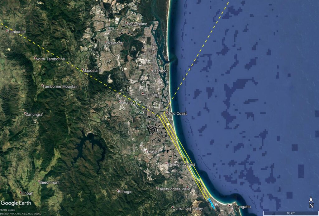
The Gold Coast ILS
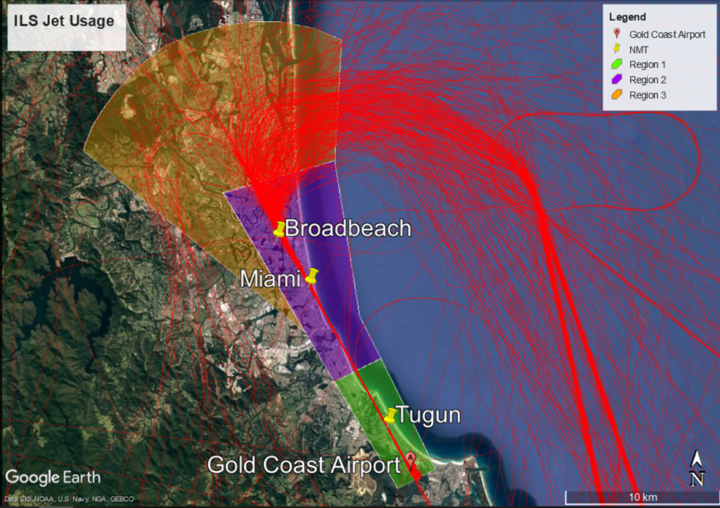
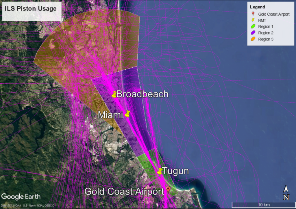
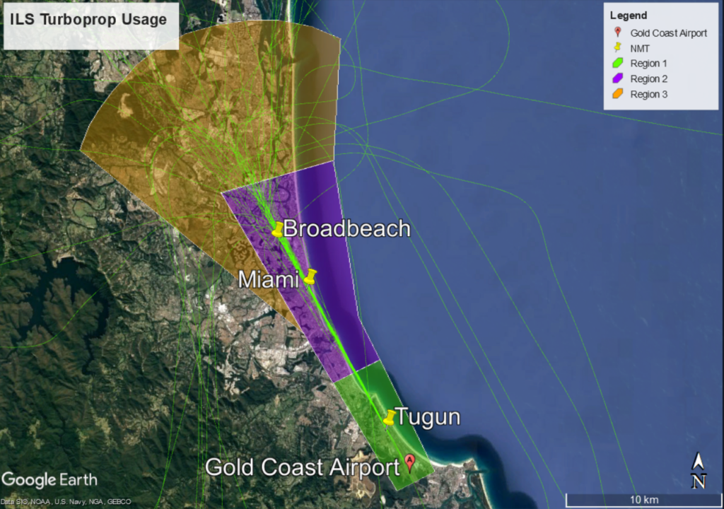
An ILS was introduced at Gold Coast Airport in early 2019. The below image shows the ILS flight path.
The ILS is designed so that arriving aircraft are vectored by Air Traffic Control within the triangular area between the dotted yellow lines (the ‘vectoring corridor’) to intercept the ‘straight-in’ ILS approach path (solid yellow lines).
ILS Flight Paths at Gold Coast Airport
Usage of the Gold Coast ILS
Analysis of flight tracks found that total ILS usage for a year (from February 2019 to February 2020) was 833 arrivals, which included 442 jet arrivals (53%) and 391 turbo prop/piston arrivals (47%). Turbo-props made up approximately 6% and piston aircraft approximately 41%. Piston aircraft are typically training aircraft under 5,700kg and therefore allowed to use the ILS under the NAPs (see NAPs section below).
On the busiest day of the year, the ILS was used 45 times. For the majority of the year (349 days), ILS usage was less than 8 arrivals per day.
Use of the ILS is seasonal due to weather patterns (e.g. storms and low visibility conditions). February 2020 was the most common month of usage, with 28% (235 arrivals) of all use occurring in this month. August 2019 was the least common month of usage with only 20 arrivals.
Jet aircraft (red) using the ILS to Runway 14 – February 2019 to February 2020
Jet aircraft are are broadly distributed (including those arriving from the south) as they approach to join the ILS. Once on the ILS their flight paths become increasingly concentrated.
Piston aircraft (pink) using the ILS to Runway 14 – February 2019 to February 2020
Piston aircraft remain more broadly distributed than jet and turbo-prop aircraft before narrowing their approach closer to the airport.
Turbo-prop aircraft (green) using the ILS to Runway 14 – February 2019 to February 2020
Turbo-prop aircraft are broadly distributed as they approach to join the ILS. Once on the ILS their flight paths become increasingly concentrated.
Noise Abatement Procedures for the ILS
Noise Abatement Procedures (NAPs) at Gold Coast Airport restrict use of the ILS except in the following circumstances:
when poor weather affects visibility
for operational requirements,
or during emergencies.
The objective of the NAPs it to limit the use of the ILS and minimise noise impacts on the community.
Weather
Weather conditions that affect visibility include low cloud and rain. When making an approach the pilot must be able to see the runway on reaching a prescribed altitude known as the “decision altitude”. If the pilot cannot see the runway by this point the landing will be aborted and a missed approach conducted. In a missed approach or “go-around” the pilot increases power, ascends and flies a circuit to prepare for a second approach. The decision altitude when using other approaches at Gold Coast Airport varies between 570 to 430 feet, while the decision altitude when using the ILS is reduced to 330 feet. Therefore the ILS provides more opportunity to land in poor visual conditions.
Air traffic control advise pilots to use the ILS when:
the cloud base is at or below approximately 800 feet (244 metres), and/or
the visibility from the air traffic control tower looking out along the ILS flight path is less than approximately 4 kilometres.
Visibility from the control tower is assessed with reference to geographical features at known distances. The ILS is nominated for use once the visibility of Tugun Hill from the tower is reduced due to weather. Tugun Hill is located 4 kilometres from the tower.
Operational requirements
The NAPs for the Preferred Approaches for Runway 14 require that the ILS be used as the last priority approach, except due to weather or operational requirement. The NAPs priority order is:
‘Smart Tracking’ (RNP-AR) approach
Area Navigation (RNAV) approach or Visual approach
Instrument Landing System (ILS) approach
If a pilot requests use of the ILS due to operational requirements, air traffic control (ATC) must follow this request. To ensure safe operation of their aircraft, the pilot-in-command always has the final say about what type of approach they require.
Training
The ILS can be used for training purposes, but:
is not permitted for aircraft with a maximum take-off weight (MTOW) above 5,700kg
is permitted for aircraft with a maximum take-off weight (MTOW) below 5,700kg (light aircraft) only between the hours of 9am and 5pm local time.
Compliance with ILS conditions of use
Of the 442 jet aircraft that arrived on the ILS (from February 2019 to February 2020), 90% used it when ATC had nominated it as the approach due to the cloud base and low visibility conditions outlined in the NAPs.
Approximately 10% of jets used the ILS approach when it was not nominated by ATC.
Reasons for this are:
aircraft attempted to fly the RNP-AR or RNAV approach, and could not sight the runway at the required decision altitude so conducted a missed approach and were then directed by ATC to use the ILS approach due to visibility
pilots advised of critical operational requirements due to on-board navigational equipment issues or emergencies
airline crews prepared for approach using the ILS and either misunderstood the application of the NAPs, or were unfamiliar with operations at Gold Coast Airport.
The ILS was not used by jet or larger turbo-prop aircraft for training.
Analysis of overall arrivals to Runway 14 found that jet and turbo-prop aircraft are using preferred approaches in the order outlined in the NAPs:
48% used the RNP-AR procedures
17% used RNAV or Visual approaches
13% used the ILS approach procedure
Over 18% of general aviation flew visual or VOR approaches.
Gold Coast ILS Post Implementation Review
In 2020 we undertook a Post Implementation Review (PIR) of the Gold Coast ILS arrival procedures.