Short Term Monitoring – Completion reports

Airservices maintains a short-term noise monitoring program around the greater Brisbane region to:

  • support airspace/flight path change reviews with quantitative data, by comparing pre-and-post-change levels
  • calibrate noise models
  • respond to requests from the Brisbane Airport Community Aviation Consultation Group (BACACG) or other community requests for noise monitoring data in specific areas.

Noise monitors are sited in areas that effectively capture noise data from the aircraft that are the focus of the monitoring program. The decisions on final locations of monitors take into account a number of other factors, including security, licensing, facilities and background noise levels. These decisions are made by Envirosuite (the global noise monitoring specialists contracted by Airservices).

Following deployment of a short-term noise monitor, Envirosuite provide a comprehensive report detailing the findings of the deployment.

Please find links below to download Brisbane short-term noise monitoring completion reports (all reports are provided as PDFs):

Brisbane Airport Corporation has conducted temporary noise monitoring around Brisbane to supplement the Airservices noise monitoring program. They have completed monitoring at:

  • Balmoral Hill (30 July – 8 October 2021)
  • Upper Brookfield (25 October 2021 – 14 January 2022)
  • Cedar Creek (7 February – 11 April 2022)
  • Coorparoo (19 May – 1 July 2022)
  • Redlands Noise Monitor including Wellington Point and Thornlands (13 January – 30 April 2023)
  • Taringa (30 May – 14 August 2023)
  • The Gap (1 November 2023 – 2 April 2024)

To view their reports click here.

Sydney Airport – heavy departures to the United States

On occasion heavy jets bound for destinations in the United States will pass over your area after departure.

Heavy jets need to use the westernmost parallel runway because it is longer. After departing towards the north from the westernmost parallel runway, aircraft bound for the USA usually turn and track to the west once they reach 1,500 feet. At twelve nautical miles they turn to the north east to track out across the coast. These outbound aircraft need to pass over inbound traffic that is flying south down the coast. For this to occur safely the outbound jets must have reached a specified altitude. However some very large aircraft on non-stop flights are so heavily laden with fuel that their climb performance is affected and they cannot reach the required altitude in time.

When this is the case the aircraft is provided with a “radar departure”, where air traffic control provide a specific heading to ensure the aircraft can pass safely through the inbound traffic. This means these aircraft fly a different route than would normally be expected, including passing over different suburbs. The route will vary for each individual aircraft depending on what other traffic is in the airspace at the time. This creates a spread across suburbs to the north of the airport.

Because there are only a small number of these flights each day, and because the suburbs overflown by each aircraft vary, residents may notice these flights as unusual for their areas.

The image below of actual aircraft tracks shows a month of flights and illustrates the spread across many suburbs.

Heavy departures

What are the rules about helicopters?

Helicopter routes

While helicopter routes exist, helicopters are not restricted to these routes. Inside controlled airspace helicopters must comply with directions from air traffic control whether flying on or off established routes. Outside controlled airspace aircraft, including helicopters, are not under the direction of air traffic control but they must comply with aviation regulations set down by the Civil Aviation Safety Authority.

Altitudes

The Civil Aviation Safety Authority have regulations for how low aircraft, including helicopters, can fly. These regulations require helicopter pilots fly no lower than 1,000 feet (ft) over built-up areas, or 500 ft over any other areas, unless they are landing or taking off.

Helicopters can fly below these heights in certain situations – for example, police, rescue, fire fighting and military helicopters may fly at any height required. 

More information is available on the CASA website.

Hovering

There are no regulations or legislation that prevent helicopters from hovering over an area. For example, media helicopters are permitted to hover while covering a story or sporting event.

If a helicopter pilot wants to cross a ‘controlled’ zone around an airport, it is sometimes necessary for air traffic control to hold the helicopter in one place until it is safe to cross. This sometimes means helicopters have to hover over built up areas.

Who makes decisions about aviation?

Responsibility for aviation operations is shared between a range of parties including Airservices, other federal government agencies, airlines and operators, pilots, airports and state and local governments.

AIRSERVICES AUSTRALIA (AIRSERVICES)

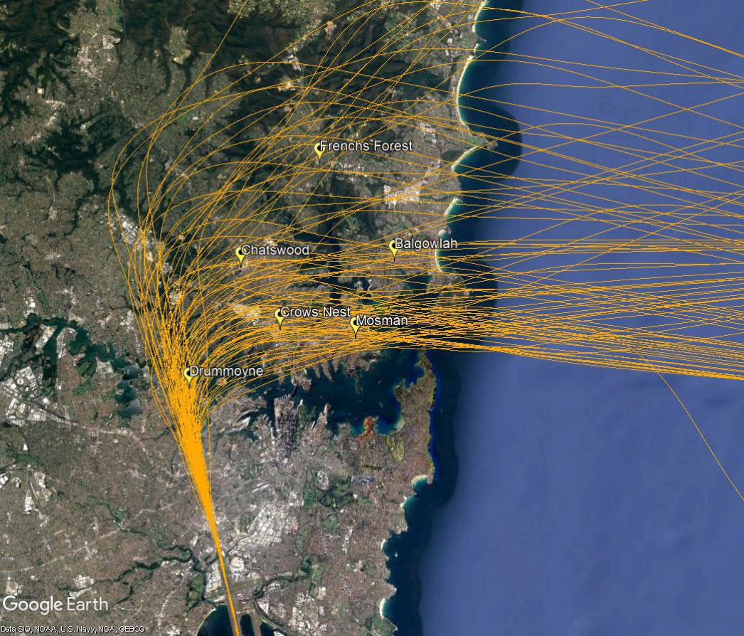
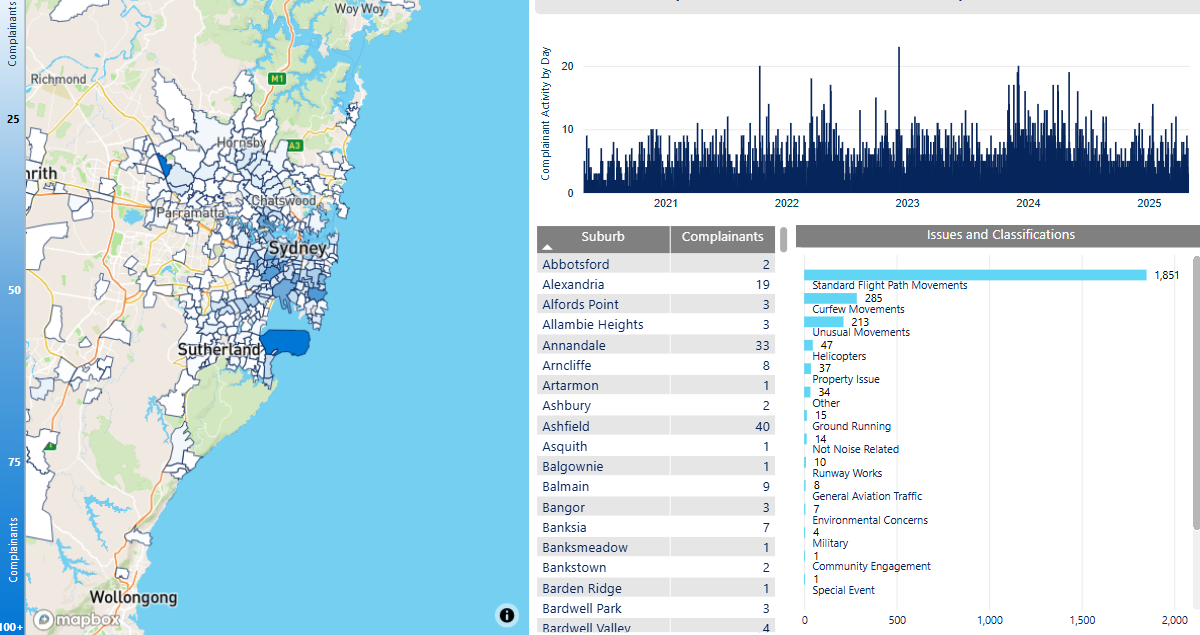
Airservices is Australia’s civil Air Navigation Service Provider (ANSP) to the aviation industry and provides aviation rescue firefighting services at 27 of Australia’s busiest airports. Airservices is a corporate Commonwealth entity established and governed by the Air Services Act 1995. Airservices publishes aeronautical data, maintains aviation telecommunication infrastructure and radio navigation aids, updates flight procedures and provides a national aircraft Noise Complaints and Information Service (NCIS).
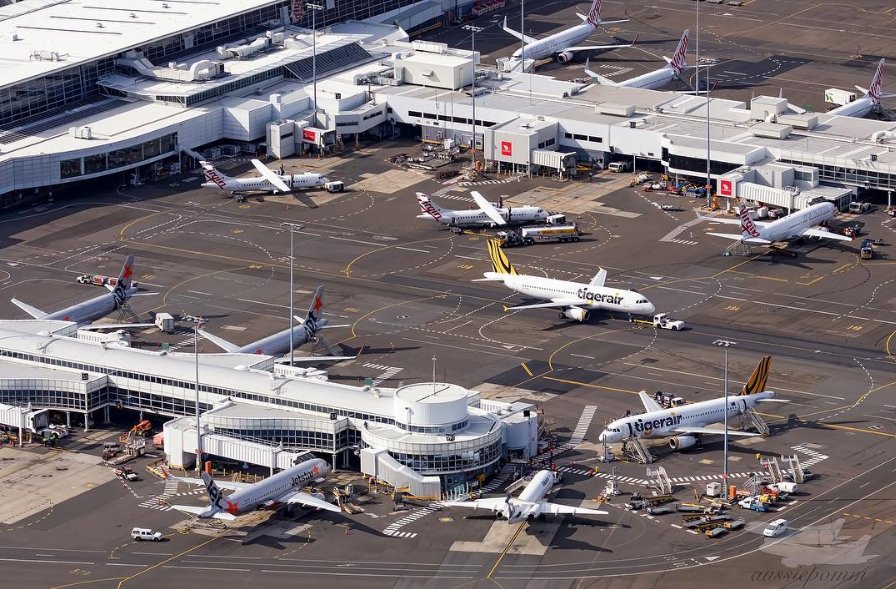
AIRPORT OPERATORS

Airport operators are the decision-makers for all on-airport activities, including developing infrastructure to support aircraft operations, such as new runways, and safeguarding aviation operations. Airport operators may also develop noise management plans, limit aircraft movements, encourage quieter fleets, prepare long-term forecasting of aircraft noise around the airport, such as the Australian Noise Exposure Forecast (ANEF), and manage local community engagement.

AIRCRAFT OPERATORS

Aircraft operators are responsible for what is referred to as “noise at source”. They make decisions about what type of aircraft they operate, what engines they equip aircraft with, and which airports they fly those aircraft to. Aircraft operators can also modify aircraft to reduce noise impacts and invest in newer fleets. All these factors can impact the noise experienced on the ground.

CIVIL AVIATION SAFETY AUTHORITY (CASA)

The Civil Aviation Authority (CASA) is a government body that regulates Australian aviation safety. It sets rules that pilots, aircraft operators, air traffic controllers and airports must comply with. CASA validates the instrument flight procedures Airservices produces and is the ultimate approver of Airspace Change Proposals.

DEPARTMENT OF INFRASTRUCTURE, TRANSPORT, REGIONAL DEVELOPMENT, COMMUNICATIONS AND THE ARTS

The Department of Infrastructure, Transport, Regional Development, Communications and the Arts (the Department) is responsible for administering Minister approval of airport infrastructure projects for federally leased airports, generally submitted through a Major Development Plan (MDP) and Environmental Impact Statement (EIS), and for providing policy advice to the Minister on the efficient management of Australian airspace and aircraft noise and emissions. The Department can make recommendations to the Government on regulatory measures to manage aircraft noise. This department is also responsible for setting the requirement for federally leased airports to produce an ANEF.

DEPARTMENT OF CLIMATE CHANGE, ENERGY, THE ENVIRONMENT AND WATER

The Department of Climate Change, Energy, the Environment and Water (DCCEEW) administers the Environment Protection and Biodiversity Conservation Act 1999 (EPBC Act) and is involved in assessing any proposed changes to aircraft operations that trigger “significance” under this Act. The Commonwealth Minister for Environment provides advice on these changes.

DEPARTMENT OF DEFENCE

The Department of Defence is responsible for aircraft operations by military aircraft at military-controlled airports. They provide information, undertake community engagement and are responsible for managing complaints about military aircraft noise.

STATE AND LOCAL GOVERNMENT

State, Territory and Local Governments are responsible for land use planning around airports through zoning, subdivision control, and comprehensive planning actions. Local Governments may also be airport owners.

AIRCRAFT NOISE OMBUDSMAN

The Aircraft Noise Ombudsman conducts independent administrative reviews of Airservices and Department of Defence management of aircraft noise-related activities.

Do planes have to stay on flight paths?

What is a flight path?

The term ‘flight path’ is used to refer to the mapped three-dimensional corridor where aircraft fly most of the time. Flight paths can be a number of kilometres wide, rather than the single lines depicted on flight charts (maps). Aircraft may fly differently within these corridors for a range of reasons, including aircraft performance (including type, speed and weight), and navigation systems.

Aircraft may deviate from flight paths for a range of reasons, including weather and operational requirements. In controlled airspace, this will be at the approval of air traffic control (ATC).

Weather diversions

During periods of bad weather aircraft may need to be diverted off the normal flight paths to avoid storm cells, heavy rain and dangerous cloud formations.  Sometimes this bad weather is not in your local area but it can be detected many nautical miles away by sophisticated weather radar systems that are installed in modern aircraft.  If a pilot requests a diversion to avoid bad weather this will be facilitated by air traffic control. This can result in aircraft flying outside the published flight paths.

Traffic management

Sometimes air traffic controllers need to take aircraft off the published flight path in order to ensure that safe separation is maintained between aircraft.  For example, this might occur when the volume of traffic in the airspace is high, such as during peak periods, or it might occur when a jet is flying behind a slower turbo-prop aircraft.  The slower plane may need to be turned off the flight path so as not to delay the faster jet.  This can result in aircraft flying outside the expected paths.

Missed approaches

A go-around, or missed approach (also sometimes referred to as an aborted landing), is a safe and well-practiced manoeuvre that sees an aircraft discontinue its approach to the runway when landing. This standard manoeuvre does not constitute any sort of emergency or threat to safety. It will however result in the aircraft flying an unusual flight path as it climbs and circles around for another approach.

The most common cause of go-arounds is adverse weather conditions, including strong winds, experienced by the aircraft on final approach. Debris on the runway, an aircraft (or vehicle) that has not yet cleared the runway or an aircraft that has been slow to take-off may also prompt go-arounds.

Emergency services operations

The published flight paths may be varied to avoid disruption to high priority emergency aircraft including aircraft involved in fighting bush fires, search and rescue, medical or police operations.

Light aircraft and helicopters

Generally, published flight paths are for aircraft flying according to Instrument Flight Rules (IFR), which is where the pilot uses instruments to fly.

Helicopters and light aircraft often fly Visual Flight Rules (VFR) where the pilot uses visual references to the ground or water and does not fly on a set flight path.

What are the rules about altitudes?

The altitudes of aircraft over your area can vary according to:

  • the airport the flight is coming from or going to
  • whether the aircraft is coming in to land, taking off or in level flight
  • the specific requirements of the flight path
  • the need for air traffic control to maintain vertical separation between aircraft.

There are no regulations setting out minimum altitudes for aircraft in the course of taking off or landing at an airport.

Variation in departure altitudes

You may observe differences in the altitudes of departing aircraft. Aircraft have different climbing abilities depending on factors such as the type of aircraft and its weight, how heavily laden it is, and even the meteorological conditions at the time.

Large jets such as Airbus A380s will climb more slowly than smaller, lighter aircraft because they are so much heavier. A380s are frequently used for long-haul non-stop flights and in these circumstances will be fully laden with fuel. This adds to the weight and further compromises climb performance. When two aircraft of the same type are observed to have different climb rates this is usually because one is heading for a closer destination than the other, and is therefore carrying less fuel weight.

Atmospheric conditions can affect climb rates. For example, when it is hot and humid the air is less dense. This affects the “lift” of an aircraft and it will take longer to climb in these conditions.

Minimum altitude for level flight

The Civil Aviation Safety Authority have regulations for how low aircraft can fly. These regulations require pilots fly no lower than 1,000 feet (ft) over built-up areas, or 500 feet over any other areas, unless they are landing or taking off.

Aircraft may be able to fly below these heights in certain situations. More information is available on the CASA website.

Noise Complaints and Information Service Report

We manage complaints and enquiries about aircraft noise and operations through our Noise Complaints and Information Service (NCIS). The information below is collected for the purpose of complaint management, analysis of issues and identification of causal factors.

For this reason we refer to ‘complainants’ and ‘issues’. Complainants are people who contacted us. While some people submitted enquiries or comments rather than complaints, all are referred to as “complainants”. Issues are the primary concern they raised.

The complaints report

Use this interactive tool to explore the issues raised by residents from different suburbs. For help, click the button in the bottom right-hand corner.

This report is best viewed in full screen mode.

Read an explanation of issues and classifications used in complaint reporting.


Will flights increase in the future in my area?

Flight Path and Airspace Changes

Visit Engage Airservices to engage with our program of flight path and airspace changes.

Airport Master Plans

Airport Master Plans provide a blueprint for the future development of an airport over a twenty year period. They include information on forecast growth, airport terminals and facilities, runways and flight paths.

Who is responsible for master planning?

Airports are responsible for producing the master plan.

Sunshine Coast Airport

The Sunshine Coast Airport Master Plan can be found on the Sunshine Coast Airport website.

How our system calculates flights over an area

The following video explains how our system calculates location-specific data used on this website:

The NFPMS

We source data directly from the Airservices Noise and Flight Path Monitoring System. The largest monitoring system in the world, combining data from air traffic control systems with a network of monitors deployed in local communities.

By using the location you provided when you entered the website, we extract data collected by this system and combine this with geographically relevant information, tailoring the site.

The grid

To be able to analyze the number of flights over your area, we have created a grid of identically sized, 1 kilometre by 1 kilometre squares. In total, the grid extends for 95 kilometres around each of the major airports in our coverage area. Initially this portal covers:

  • Adelaide
  • Brisbane
  • Cairns
  • Canberra
  • Gold Coast
  • Hobart
  • Melbourne
  • Perth
  • Sunshine Coast
  • Sydney

How we count the number of flights

We start by drawing a cone at the centre of each grid. Using the location that you provided when you entered the site, we determine the nearest cone to you.

Flights that pass through each cone are recorded and that
data is presented on this website.

To avoid underestimating the flights in each area and to fully cover all locations in our grid, we lower the cone 2,600 feet (800 metres) into the ground.

The cone extends up to 15,000 feet (4.5 kilometres) above local ground level and at the very top, the cone is over 30,000 feet (9.4 kilometres) wide.

Why we use a cone

We use a cone because research undertaken by the United Kingdom Civil Aviation Authority identified that a cone best aligns with how we determine if an aircraft has overflown a location or not.

The 48.5-degree angle of the cone was selected as it incorporates an evaluation of noise, in that if one aircraft flew directly above the observer, followed by a second aircraft off to the side along the 48.5 degree line, the second aircraft would be 3 decibels quieter than the first.

Investigation: Curfew operations during daylight savings

During daylight savings the airport curfew operates on Queensland time with the result that NSW residents can be exposed to aircraft movements until 12 am instead of 11 pm. In 2015, a complainant asked us to investigate whether the preferred runway under the noise abatement procedures could be changed to Runway 32 (rather than Runway 14) between 10 pm and 11 pm Queensland time during daylight saving periods.

Data analysis of movements between 10 pm and 11 pm over three months found that movement numbers were low at this time. There were no movements at all on 33 nights, one movement on 34 nights, two movements on 17 nights, and three to four movements on seven nights.

Comparison of runway usage during the data collection period showed that usage of either runway at this time of year appeared to be almost equally shared, which weakened the case for a change of runway preference.

Because there are approximately three times more arrival movements than departures, for suburbs south of the airport, the proposed change would have a greater negative effect on those areas that are affected by arrival traffic than the positive effect it could have on some areas affected by departure traffic. All these areas south of the airport are in NSW and as such would be on daylight saving time.

The proposal was considered feasible from a safety and efficiency perspective. However, the low number of flights per night in the time period, the fact that many of these are spread between the north and south of the airport, and the fact that the majority of operations are arrivals rather than departures, indicated that any noise improvement would be minimal.

While there might be very small benefits for residents to the south of the Airport that are not overflown by arrival traffic, such as the residents of Fingal Head, this is a small population compared to the area that would either receive no benefit or would experience a worsening of their situation, such as suburbs in NSW under the arrival path and suburbs to the north including Tugun and Currumbin.

On balance, we found that there are insufficient departures between 10.00pm and 11.00 pm during daylight savings periods to outweigh potential negative impacts of the proposed change on other areas and qualify as a noise improvement for the whole community.