Brisbane airport community aviation consultation group

Federally-leased airports (excluding Mt. Isa and Tennant Creek) have established Community Aviation Consultation Groups (CACGs), which provide an effective avenue for local community engagement on airport planning and operations, including aircraft noise. The Department for Infrastructure, Transport, Regional Development and Communications provides guidelines for CACGs.

Non federally-leased airports may also choose to establish CACGs or community forums.

CACG membership depends on the characteristics of the airport and any local issues of community concern however, generally includes:

  • airport management
  • aircraft operators
  • community organisations or representatives
  • representatives from state, territory or local government bodies
  • local tourism and business groups.

Airservices does not formally belong to CACGs, but is invited to attend to provide relevant information and assist in discussions. We engage with CACGs on flight path and airspace changes, as well as technical reviews, such as noise monitoring and noise abatement procedures.

Find out more information on the Brisbane Airport Community Aviation Consultation Group webpage.

RAAF Amberley

The Air Force undertakes routine flying activities at RAAF Base Amberley. The majority of the flying training occurs in designated training areas, situated over farming, rural and overwater areas, which helps reduce the time aircraft spend over residential areas.

Amberley Flying Training Areas include:

  • Western Training Area: The western training area is essential airspace for training all RAAF Base Amberley aircraft including the F/A-18F Super Hornet, KC-30A Multi Role Tanker Transport aircraft and the C-17A Globemaster III. The western training area airspace is located west of RAAF Base Amberley and commences south west of Toowoomba.
  • Over water training areas: The Northern Training Area, Northern Bridge, Central Training Area, Southern Training Area, and Southern Bridge are airspaces located overwater to the East of the coastline.
  • Evans Head: The Evans Head Air Weapons Range is primarily used by Amberley based F/A-18F Super Hornets to conduct ground attack training. This is the only weapons range within the training radius of the F/A-18F Super Hornet aircraft from their home base at Amberley.

Noise Mitigation

The Department of Defence Aircraft Noise Management Strategy outlines how they work with local communities to reduce noise impacts, while balancing operational and training requirements.

Flying operations are conducted in consideration of local communities, whilst maintaining the safe operation of the aircraft. More information can be found in the:

You can access more information on military aircraft activity at:

Archerfield Fly Neighbourly

Fly Neighbourly Advice or Fly Neighbourly Agreements are voluntary agreements established between aircraft operators and communities or authorities (normally airports or local councils) to assist in reducing the impact of aircraft noise on local communities. Archerfield Airport has a voluntary Fly Neighbourly program, which encourages pilots to fly in a noise sensitive way whenever possible.

Will flights increase in the future in my area?

Flight Path and Airspace Changes

Visit Engage Airservices to engage with our program of flight path and airspace changes.

Airport Master Plans

Airport Master Plans provide a blueprint for the future development of an airport over a twenty year period. They include information on forecast growth, airport terminals and facilities, runways and flight paths.

Who is responsible for master planning?

Airports are responsible for producing the master plan, while the overall process is administered and regulated by the Department of Infrastructure, Transport, Regional Development and Communications.

Brisbane Airport

The Brisbane Airport Master Plan can be found on the Brisbane Airport website.

The Brisbane Noise and Flight Path Monitoring System (NFPMS)

We collect noise and operational data from ten long term noise monitors (NMT) around Brisbane Airport. As part of the new runway opening we worked with BAC to install four additional short term noise monitors which are currently in place until July 2022. These short term noise monitors are located at Bardon, Carina, Hamilton and New Farm.

Long term noise monitors are listed below according to their location.

Access monthly data on our Brisbane noise monitoring reports page.

Tingalpa and Nudgee Beach

NMT 2 (Tingalpa)

Tingalpa (NMT 2):

Captures departures from Runway 19L to the south and arrivals to Runway 01R from the south.

NMT 3 (Nudgee Beach)

Nudgee Beach (NMT 3):

Captures departures from Runway 01L/19R to the north and arrivals to Runway 19R from the north.

Bulimba and Kedron

NMT 63 (Bulimba)

Bulimba (NMT 63):

Captures arrivals to Runway 01L and 01R and departures to the north from Brisbane Runway 19L and 19R.

NMT 54 (Kedron)

Kedron (NMT 54):

Captures arrivals to Runway 01L and departures from Runway 01R and 19R.

Cannon Hill and Annerley

NMT 55 (Cannon Hill)

Cannon Hill (NMT 55):

Captures arrivals to Runway 01L and 01R and departures to the north from Brisbane Runway 19L and 19R.

NMT 9 (Annerley)

Annerley (NMT 9):

Captures arrivals to Runway 01L and 01R and departures from Runway 19L and 19R.

Salisbury and St Lucia

NMT 10 (Salisbury)

Salisbury (NMT 10):

Captures arrivals to Runway 01L and 01R, including ILS approaches.

Due to proximity to Archerfield Airport, some aircraft from Archerfield Airport which operate to the north-east of the airport will also be captured.

NMT 11 (St Lucia)

St Lucia (NMT 11):

Captures arrivals to Runway 01L and departures from Runway 19L and 19R.

Runway Ends

NMT 61 (Runway End 19L)

Runway End 19L (NMT 61):

Captures arrivals to Runway 01R and departures from Runway 19L.

NMT 62 (Runway End 19R)

Runway End 19R (NMT 62):

Captures arrivals to Runway 01L and departures from Runway 19R.


Learn more about monitoring aircraft noise on the Airservices website.

Brisbane Airport Runways

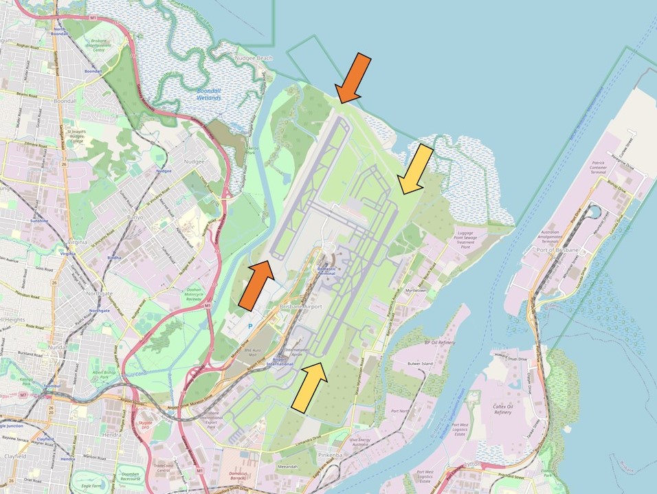
Brisbane Airport has two parallel runways oriented North-South – Runway 01R/19L (existing/legacy), and Runway 01L/19R (new) which opened on 12 July 2020. Both runways are shown in the image below with orange and yellow arrows at either end.

The image below shows the runways, with:

  • The orange arrows pointing to Runway 01L/19R
  • The yellow arrows pointing to Runway 01R/19L.

A cross runway (14/32) was de-commissioned as part of the construction of the new runway.

Each runway is referred to differently according to in which direction it is being used, as explained in the following video.

When Brisbane airport is operating in a northerly direction runways 01R and 01L are in use, and runways 19L and 19R are used when the airport is in a southerly direction.

Runway numbering reflects the runways’ orientation and correlates with degrees on a compass. Runway 19 is at 190 degrees.

Runway selection

Operations are divided into two time periods. The day period is 6am to 10pm and the night period is 10pm to 6am.

During the day period, the runway used is based on the planned route of the aircraft. Aircraft planning a route through the north or the west use the new runway, and through the east or the south, the legacy runway.

At night aircraft will when possible operate over Moreton Bay. Arrivals use one runway and departures the other. As the overnight traffic volume is light, aircraft can more readily operate in the same airspace.

Weather conditions

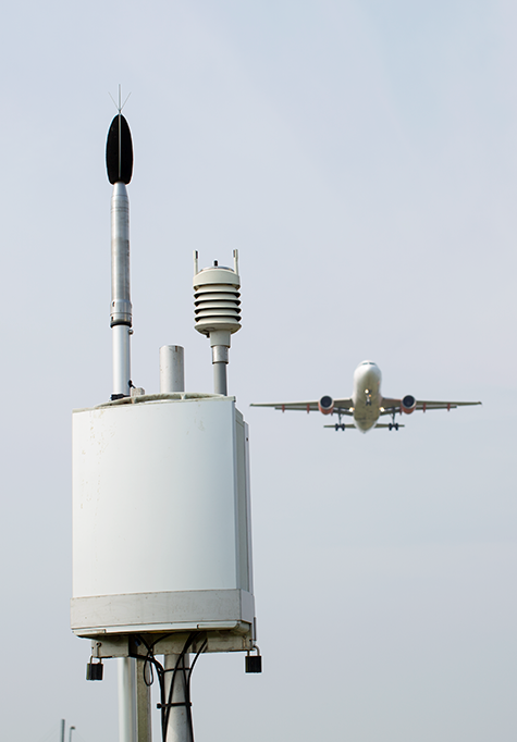
Runway selection is based on wind direction, weather conditions, traffic volume and other factors. Aircraft primarily take-off and land into the wind for safety and performance reasons. Therefore, as the wind direction changes the runway in operation may also change depending on the strength of the wind.

Australia’s Civil Aviation Safety Authority (CASA) sets the rules for the provision of Air Traffic Control services. These rules include criteria applying to air traffic control for nominating the runway direction.

If a runway surface is dry, it should not be nominated for use if the downwind exceeds 5 knots. Downwind is wind that blows towards the tail of the aircraft. If the runway surface is wet, it should not be nominated if there is any downwind. For this reason the runway that is nominated for use will usually have a headwind, or if there is downwind, it will be below the criteria.


Learn more about seasonal changes in your area on our How seasonal variation affects your area page.

Helicopter and nearby routes

The airspace surrounding Brisbane Airport is controlled from the ground level up. The base of the controlled airspace rises moving outwards from Brisbane Airport, with the airspace below the base being uncontrolled. Light aircraft and helicopters often remain in uncontrolled airspace to remain separated from large passenger aircraft that transit through controlled airspace.

The following image shows light aircraft and helicopter movements in uncontrolled airspace throughout the Brisbane region. As you can see, these flights remain clear of Brisbane Airport:

This however does not mean light aircraft and helicopters are restricted from entering controlled airspace. In order to access this airspace, the aircraft operator requires an airspace clearance and is obligated to abide by air traffic control directions once in the controlled airspace. In the Brisbane region, the most common user of this airspace apart from Brisbane Airport traffic is medical helicopters flying to and from local hospitals. The following image shows some of these flights:

Archerfield Airport also has a pocket of controlled airspace surrounding the airport. A difference to Brisbane’s controlled airspace though is that Archerfield’s is only active from 7:00am – 5:00pm. Outside of these hours the airspace around Archerfield is uncontrolled.

In busy airspace where there is a mix of controlled and uncontrolled airspace, lanes are often established to ensure pilots transiting through the airspace remain outside of controlled airspace. One such lane passes between Brisbane’s and Archerfield’s control zones. The following image shows aircraft using this lane. The control zones for Brisbane Airport and Archerfield Airport are shaded grey. Pilots navigating along these lanes do so with visual reference to landmarks that are easy to recognise from the air which in this case is the University of Queensland and the brickworks in Rochedale. Both of this places are referenced on the map:

Noise Complaints and Information Service Report

We manage complaints and enquiries about aircraft noise and operations through our Noise Complaints and Information Service (NCIS). The information below is collected for the purpose of complaint management, analysis of issues and identification of causal factors.

For this reason we refer to ‘complainants’ and ‘issues’. Complainants are people who contacted us. While some people submitted enquiries or comments rather than complaints, all are referred to as “complainants”. Issues are the primary concern they raised.

The complaints report

Use this interactive tool to explore the issues raised by residents from different suburbs. For help, click the button in the bottom right-hand corner.

This report is best viewed in full screen mode.

What was that flight?

WebTrak is a tool that enables the community to see where aircraft fly and explore historical trends and patterns. WebTrak is provided by Envirosuite.

WebTrak uses information from air traffic control radars to display aircraft movements. The flight search and display function allows you to view aircraft flight activity over metropolitan areas. You can also:

  • locate your street address and have your home appear on the map
  • see noise levels of individual aircraft
  • view information about aircraft type, height, origin and destination
  • display an aircraft’s flight path and point of closest approach to your home
  • zoom in and out down to street level.

Note that there is a slight delay on the display of flights.

You can view WebTrak for your region here.

Or, find out more information about WebTrak and how to use it

How frequent are flights in my area?

There are a number of factors that influence the frequency of flights.

Firstly, the number and frequency of flights will vary on a daily, weekly and yearly basis due to differences in airline schedules. The airlines schedule flights in response to consumer demand. This is particularly the case around Christmas, Easter, school holidays and Lunar New Year.

Secondly, the runway in use at any given time will also vary, largely due to the wind conditions. Each runway has its own set of flight paths, and each flight path will affect different areas. As the runway in use changes, the flight paths change, and so too do the areas affected by aircraft movements.

This chart shows the total number of flights each hour over the month, compared to the average for last year. Change the selected month to see how it has varied.