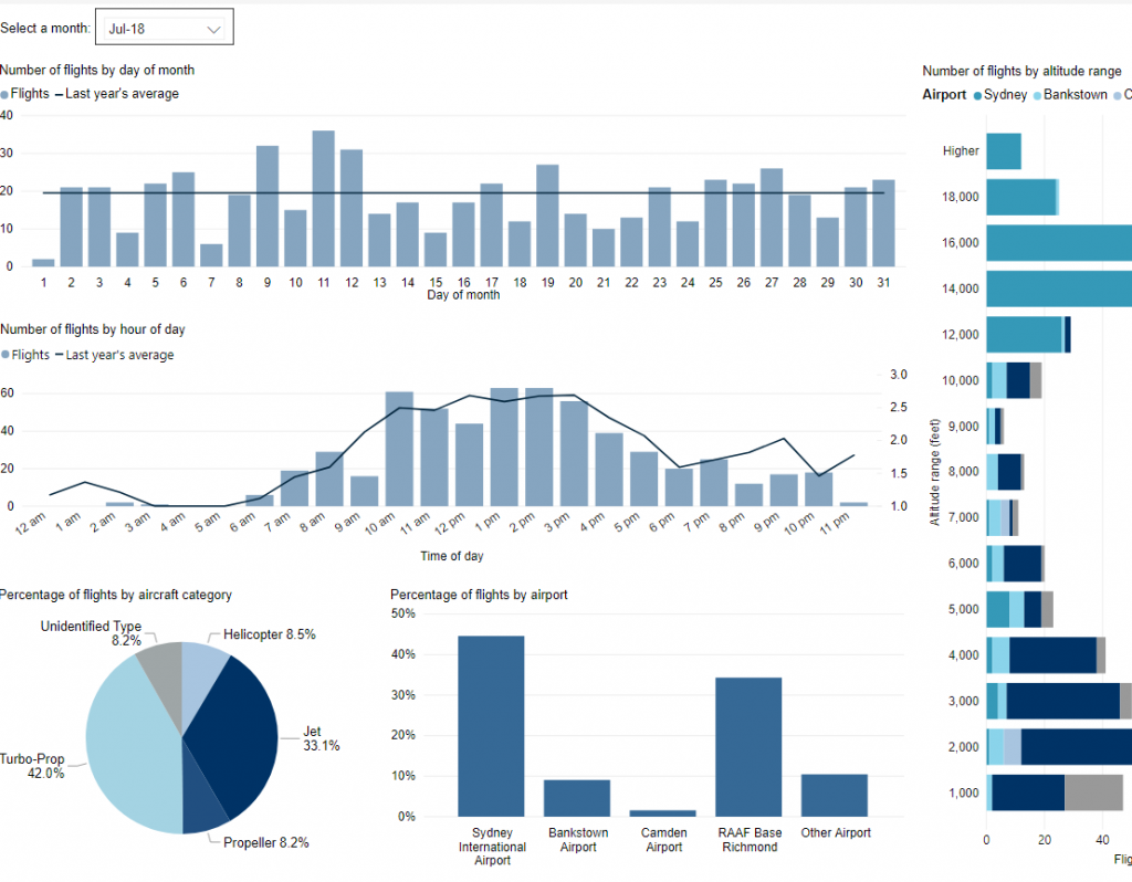
Use this interactive tool to explore detailed data for your area in the month of your choice.
This report is best viewed in full screen mode.
Use this interactive tool to explore detailed data for your area in the month of your choice.
This report is best viewed in full screen mode.
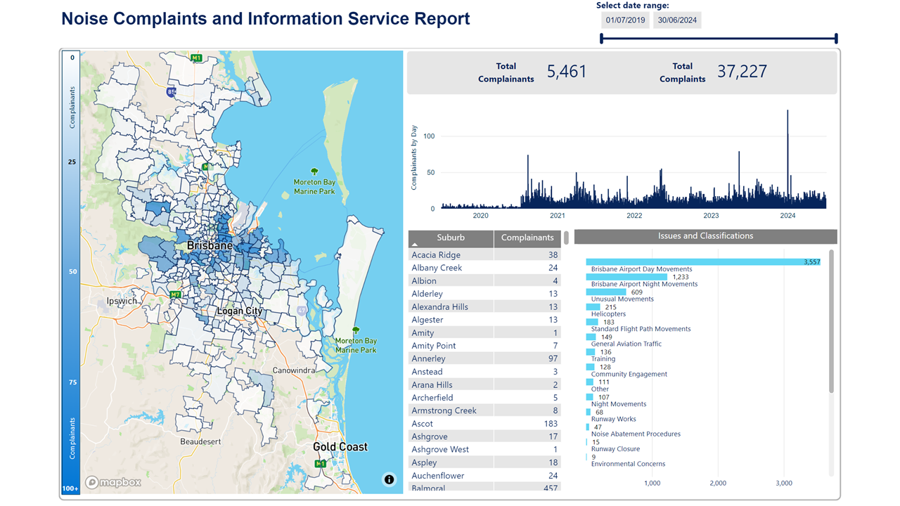
We manage complaints and enquiries about aircraft noise and operations through our Noise Complaints and Information Service (NCIS). The information below is collected for the purpose of complaint management, analysis of issues and identification of causal factors.
For this reason we refer to ‘complainants’ and ‘issues’. Complainants are people who contacted us. While some people submitted enquiries or comments rather than complaints, all are referred to as “complainants”. Issues are the primary concern they raised.
Use this interactive tool to explore the issues raised by residents from different suburbs. For help, click the button in the bottom right-hand corner.
This report is best viewed in full screen mode.

An Instrument Landing System (ILS) is a navigational aid that emits radio signals to provide vertical and horizontal guidance to pilots landing in low-visibility and inclement weather conditions. This type of system requires a flight path that extends in a straight line from the runway.
Airports without an ILS can experience higher levels of missed approaches, unstable approaches and in some cases, diversions to alternate airports when safe landing is not possible.
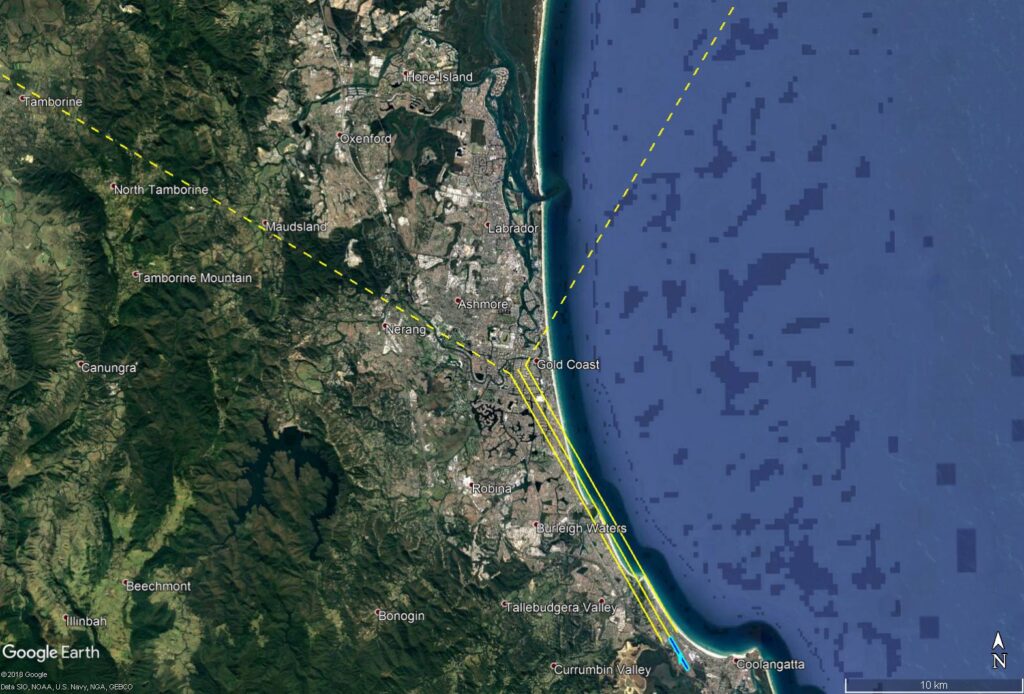
An ILS was introduced at Gold Coast Airport in early 2019. The below image shows the ILS flight path.
The ILS is designed so that arriving aircraft are vectored by Air Traffic Control within the triangular area between the dotted yellow lines (the ‘vectoring corridor’) to intercept the ‘straight-in’ ILS approach path (solid yellow lines).
Analysis of flight tracks found that total ILS usage for a year (from February 2019 to February 2020) was 833 arrivals, which included 442 jet arrivals (53%) and 391 turbo prop/piston arrivals (47%). Turbo-props made up approximately 6% and piston aircraft approximately 41%. Piston aircraft are typically training aircraft under 5,700kg and therefore allowed to use the ILS under the NAPs (see NAPs section below).
On the busiest day of the year, the ILS was used 45 times. For the majority of the year (349 days), ILS usage was less than 8 arrivals per day.
Use of the ILS is seasonal due to weather patterns (e.g. storms and low visibility conditions). February 2020 was the most common month of usage, with 28% (235 arrivals) of all use occurring in this month. August 2019 was the least common month of usage with only 20 arrivals.
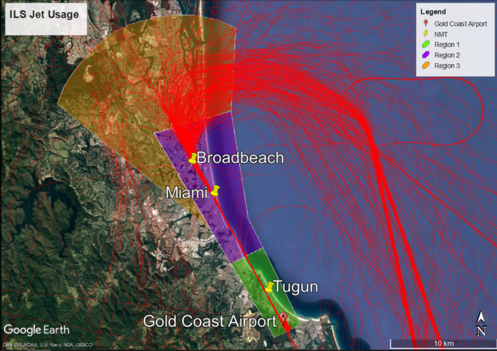
Jet aircraft are are broadly distributed (including those arriving from the south) as they approach to join the ILS. Once on the ILS their flight paths become increasingly concentrated.
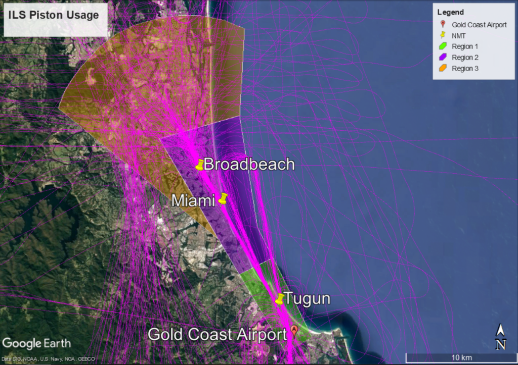
Piston aircraft remain more broadly distributed than jet and turbo-prop aircraft before narrowing their approach closer to the airport.
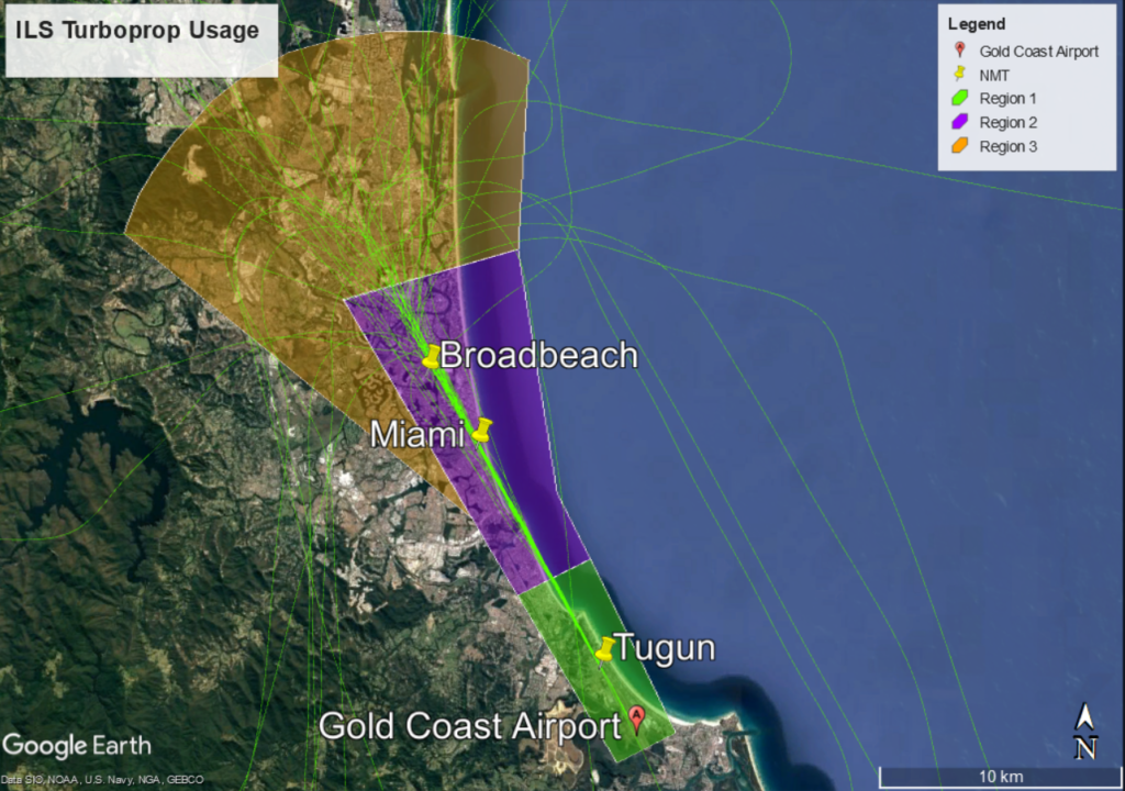
Turbo-prop aircraft are broadly distributed as they approach to join the ILS. Once on the ILS their flight paths become increasingly concentrated.
Noise Abatement Procedures (NAPs) at Gold Coast Airport restrict use of the ILS except in the following circumstances:
The objective of the NAPs it to limit the use of the ILS and minimise noise impacts on the community.
Weather conditions that affect visibility include low cloud and rain. When making an approach the pilot must be able to see the runway on reaching a prescribed altitude known as the “decision altitude”. If the pilot cannot see the runway by this point the landing will be aborted and a missed approach conducted. In a missed approach or “go-around” the pilot increases power, ascends and flies a circuit to prepare for a second approach. The decision altitude when using other approaches at Gold Coast Airport varies between 570 to 430 feet, while the decision altitude when using the ILS is reduced to 330 feet. Therefore the ILS provides more opportunity to land in poor visual conditions.
Air traffic control advise pilots to use the ILS when:
Visibility from the control tower is assessed with reference to geographical features at known distances. The ILS is nominated for use once the visibility of Tugun Hill from the tower is reduced due to weather. Tugun Hill is located 4 kilometres from the tower.
The NAPs for the Preferred Approaches for Runway 14 require that the ILS be used as the last priority approach, except due to weather or operational requirement. The NAPs priority order is:
If a pilot requests use of the ILS due to operational requirements, air traffic control (ATC) must follow this request. To ensure safe operation of their aircraft, the pilot-in-command always has the final say about what type of approach they require.
The ILS can be used for training purposes, but:
Of the 442 jet aircraft that arrived on the ILS (from February 2019 to February 2020), 90% used it when ATC had nominated it as the approach due to the cloud base and low visibility conditions outlined in the NAPs.
Approximately 10% of jets used the ILS approach when it was not nominated by ATC.
Reasons for this are:
The ILS was not used by jet or larger turbo-prop aircraft for training.
Analysis of overall arrivals to Runway 14 found that jet and turbo-prop aircraft are using preferred approaches in the order outlined in the NAPs:
Over 18% of general aviation flew visual or VOR approaches.
In 2020 we undertook a Post Implementation Review (PIR) of the Gold Coast ILS arrival procedures.
More information about the PIR can be found on Engage Airservices.
The Gold Coast is popular with domestic and international tourists and this creates demand for helicopter joy flights and scenic helicopter tours. In general, these operations increase when the weather is fine and clear and during holiday periods. There also tends to be an increase of this activity coinciding with Chinese New Year celebrations.
There are a significant amount of helicopters involved in recreational activities in and around the Gold Coast area. They operate from helipads in the Southport area, such as Sea World and the Marina Mirage. These helicopter activities are considered as ‘standard operations’ and are permitted.
An extract of the typical paths used by these aircraft is shown in the following image:
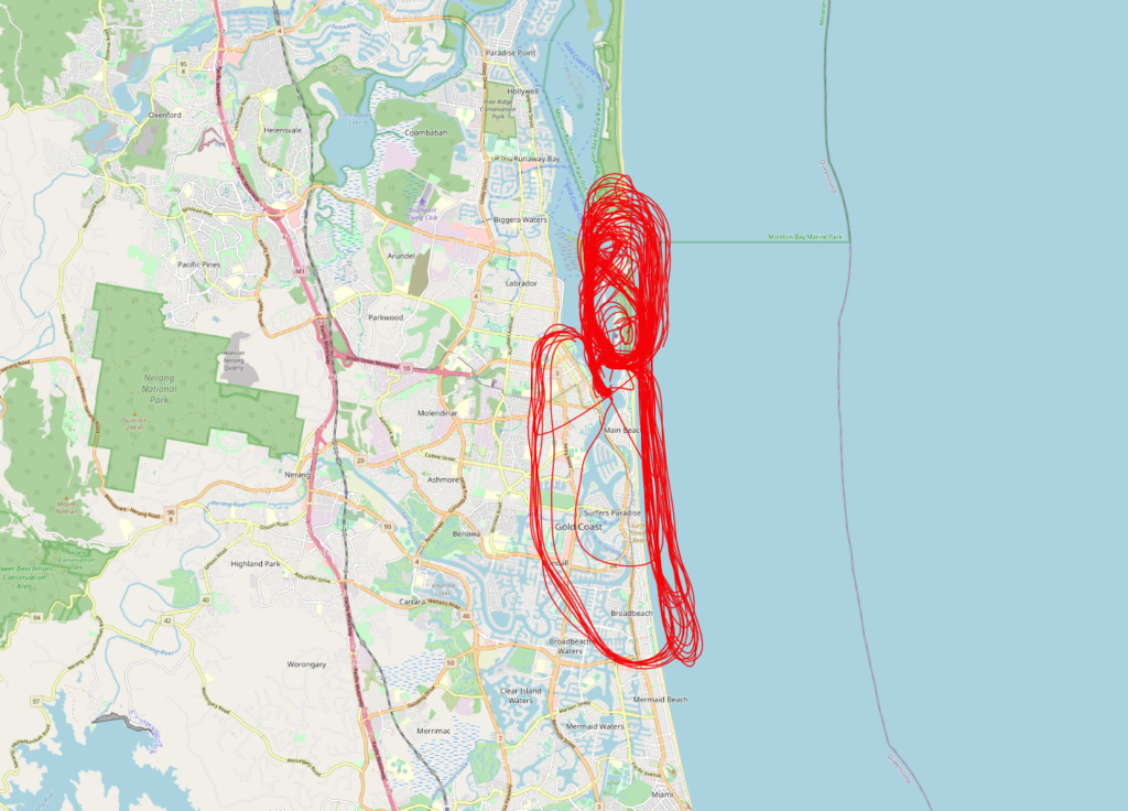
The majority of light aircraft and helicopters operate outside or underneath controlled airspace, and this is the case for the helicopters operating at the northern end of the Gold Coast. As the airspace is uncontrolled, these operations are not under the direction of air traffic control however Civil Aviation Safety Authority Regulations still apply and must be adhered to.
Helicopter tour companies use a number of noise mitigation strategies such as varying their tracking to ensure they are not overflying the same residences each flight. Pilots are instructed to climb as quickly as possible and to avoid situations that increase rotor blade slap.
Helicopters, like fixed-wing aircraft land and take-off into the wind for safety reasons. This means the wind direction at the helipad usually determines whether or not they depart to the north or to the south. While the scenic route is similar regardless of the departure direction, residents will observe flights in opposite directions at times and as a result the altitudes of the helicopters may differ between flights.

Every major airport has Noise Abatement Procedures (NAPs), which are procedures designed to reduce the impact of aircraft noise on the community. There are some limitations to the use of NAPs and they may not be used if they generate delay and congestion, as this can cause noise and emission impacts. Air traffic control or pilots may not be able to use them in certain situations, for example weather conditions or operational requirements.
The main Noise Abatement Procedures currently in use at Brisbane Airport are:
Air traffic control nominates the runway for use to ensure safety and operational requirements are met, depending on the weather conditions. If weather conditions do not favour a specific runway, the ‘preferred’ runway is used, two of the main points are set out below.
If the downwind in the southerly direction exceeds 5 knots or there is downwind and the surface is wet, to comply with runway selection criteria, northerly runway direction operations will be nominated. Aircraft will then land over the city and depart over the bay. If conditions change quickly and the forecast suggests it may continue to change, a change of runway direction may not occur immediately or at all, if our air traffic controllers are satisfied that the runway selection criteria is adhered to.
During night operations (10 pm to 6 am) Simultaneous Opposite Direction Parallel Runway Operations (SODPROPS) is the preferred operating mode. SODPROPS sees all aircraft operate over the bay by using one runway for departures and the other for arrivals.
To operate SODPROPS visibility must be eight kilometres or greater, the cloud base must be 2500 feet or higher, the downwind must be less than 5 knots and the runway surfaces must be dry.
If SODPROPS cannot be used, the NAPs specify that the southern end of the new runway should not be used during the night period.
SODPROPS sees all aircraft operate in the same airspace. This means aircraft are ascending and descending in the same airspace and regularly crossing flight paths. This complexity prohibits the use of SODPROPS during busy periods which tends to be throughout the day period. Our air traffic controllers will use SODPROPS during day operations when possible however the traffic density often precludes this. At this time, while traffic numbers are lower than expected, we tend to see the SODPROPS mode maintained after 6am and commence prior to 10pm.
The NAPs specify that aircraft heavier than 30 000 kilograms cannot use an intersection departure, except when complying with certain ICAO requirements.
Any aircraft below this weight can use an intersection departure and will do so if necessary.
Intersection departures are not permitted by any aircraft between 10pm and 6am, with the exception of a limited number of turbo-prop aircraft from 5am.
We will implement a temporary Noise Abatement Procedure to adjust the turbo-prop traffic spread to match what would have been experienced had COVID-19 not affected traffic volumes. This will increase operations in the areas between the short and long approaches (the swathe) during periods of high demand, while the shorter visual approach will still occur when traffic volumes are generally lower.
This temporary procedure will be in place until operations increase to both runways, which will then result in a similar traffic management outcome – with more aircraft operating within the ‘swathes’.
Learn more about turbo-prop operations during COVID-19 on our How do turbo-prop aircraft fly? page.
Visit Engage Airservices to engage with our program of flight path and airspace changes.
Airport Master Plans provide a blueprint for the future development of an airport over a twenty year period. They include information on forecast growth, airport terminals and facilities, runways and flight paths.
Airports are responsible for producing the master plan, while the overall process is administered and regulated by the Department of Infrastructure, Transport, Regional Development and Communications.
The Sydney Airport Master Plan 2039 and Environment Strategy 2019 – 2024 can be found on the Sydney Airport website.
The Bankstown and Camden Airports Master Plans can be found on the Sydney Metro Airports website.