Learn about flight paths and aircraft movements in your area
Welcome to the Aircraft in Your Neighborhood Portal
Our goal is that you will learn more about the flight paths and aircraft movements in your area and be able to access the information and resources that explain how air traffic is managed.
First, please select your location using one of the following options, so that we can customize the information for your location.
We’ll remember your location so you don’t have to enter it every time you visit the site and we’ll keep this information confidential.
Please note, that this site works best on Chrome, Firefox and Edge.
* Mandatory - Select region first to view the map.
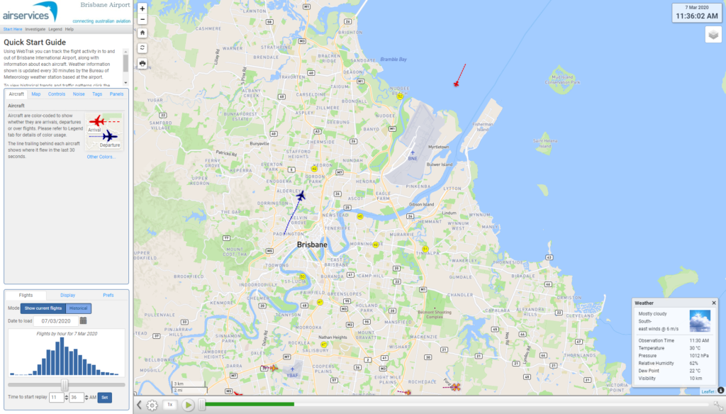
WebTrak is a tool that enables the community to see where aircraft fly and explore historical trends and patterns. WebTrak is provided by Envirosuite.
WebTrak uses information from air traffic control radars to display aircraft movements. The flight search and display function allows you to view aircraft flight activity over metropolitan areas. You can also:
locate your street address and have your home appear on the map
see noise levels of individual aircraft
view information about aircraft type, height, origin and destination
display an aircraft’s flight path and point of closest approach to your home
zoom in and out down to street level.
Note that there is a slight delay on the display of flights.
There are a number of factors that influence the frequency of flights.
Firstly, the number and frequency of flights will vary on a daily, weekly and yearly basis due to differences in airline schedules. The airlines schedule flights in response to consumer demand. This is particularly the case around Christmas, Easter, school holidays and Lunar New Year.
Secondly, the runway in use at any given time will also vary, largely due to the wind conditions. Each runway has its own set of flight paths, and each flight path will affect different areas. As the runway in use changes, the flight paths change, and so too do the areas affected by aircraft movements.
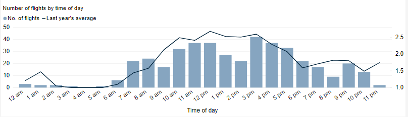
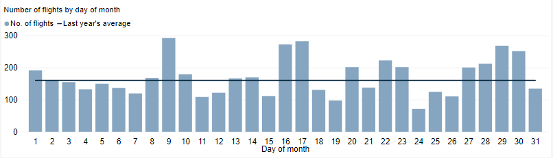
This chart shows the total number of flights each hour over the month, compared to the average for last year. Change the selected month to see how it has varied.
This tool shows the number of flights each day over your area in the selected month compared to the average for last year. The bottom axis shows the day of the month. Use the drop-down menu to change the selected month to see how movements have varied. Hover over each day to see flight numbers.
Visit Engage Airservices to engage with our program of flight path and airspace changes.
Airport Master Plans
Airport Master Plans provide a blueprint for the future development of an airport over a twenty year period. They include information on forecast growth, airport terminals and facilities, runways and flight paths.
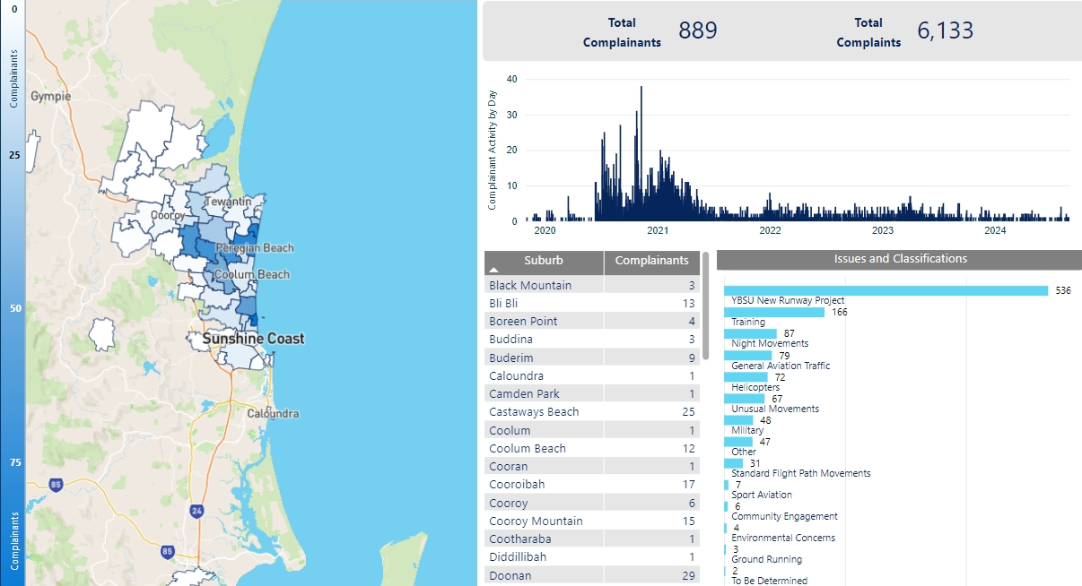
We manage complaints and enquiries about aircraft noise and operations through our Noise Complaints and Information Service (NCIS). The information below is collected for the purpose of complaint management, analysis of issues and identification of causal factors.
For this reason we refer to ‘complainants’ and ‘issues’. Complainants are people who contacted us. While some people submitted enquiries or comments rather than complaints, all are referred to as “complainants”. Issues are the primary concern they raised.
The complaints report
Use this interactive tool to explore the issues raised by residents from different suburbs. For help, click the button in the bottom right-hand corner.
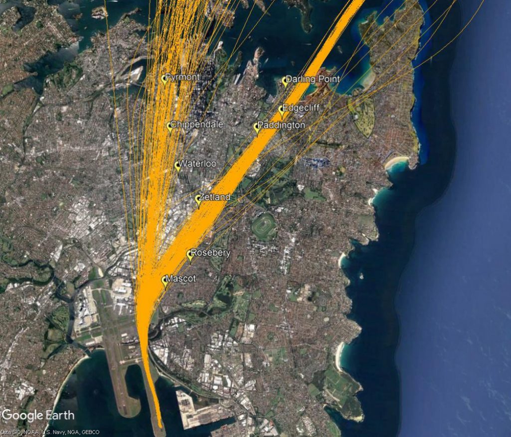
The eastern suburbs are primarily affected by aircraft departing from the easternmost parallel runway (Runway 34 Right) when the runways are being used in a northerly direction (“north flow”).
Most aircraft departing the easternmost parallel runway turn to the east or north-east after take-off. Aircraft that turn north-east are bound for northerly destinations such as Brisbane, the Gold Coast and Sunshine Coast. They will pass over suburbs including Rosebery, Paddington and Double Bay. Non-jets bound for northerly destinations will continue straight ahead after take-off over suburbs such as Pyrmont.
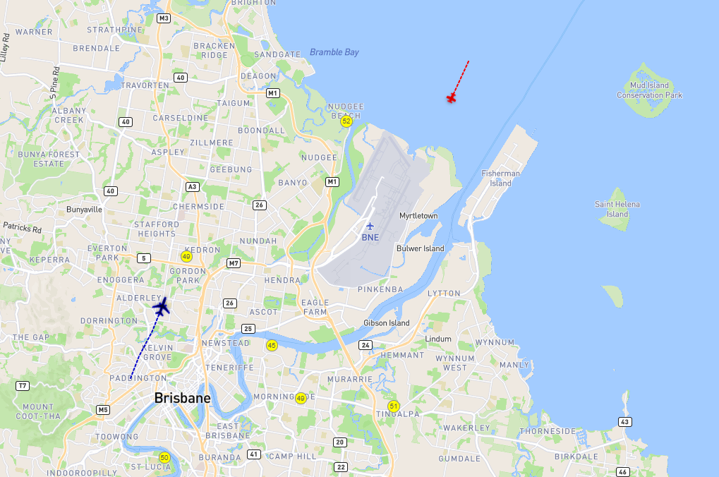
The aircraft that turn north-east begin their turns when they reach 500 feet in altitude. As different types of aircraft have different climbing abilities, they will reach this altitude at different points after take-off and therefore begin their turns at different points in the air. This has the effect of creating a spread of aircraft. This spread can be seen in the image below which shows actual tracks of aircraft on this flight path. The non-jet flight path is also shown heading directly north.
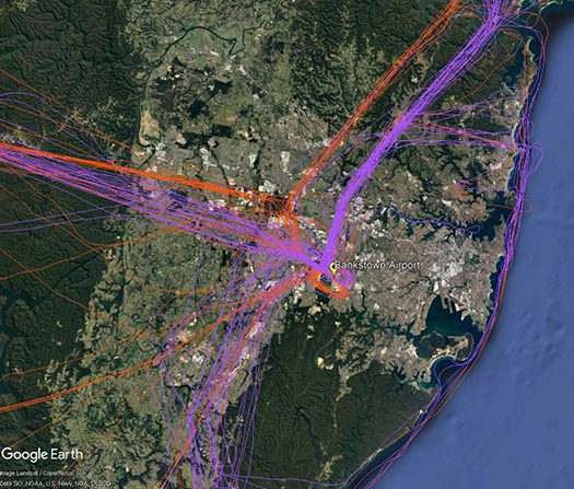
There are a number of routes around Sydney used by light aircraft and helicopters.
It is not mandatory that light aircraft and helicopters fly on these routes. As you will see from the images below which show the tracks of actual flights, some aircraft may fly the whole route but others may only fly part of it, joining or leaving it depending on their purpose or destination. Other aircraft may not use the routes at all.
These routes are mainly outside controlled airspace (“OCTA”), that is, aircraft are not being directed by air traffic control. Whenever they fly outside controlled airspace, pilots are following the rules of the air. Our booklet, Guide to our Operations, explains more about different types of airspace.
Pilots using these routes are usually flying under Visual Flight Rules, which means they navigate using landmarks that are easily seen from the air. This does not mean they must fly over each landmark; rather, they use each landmark to be sure of their position.
Most of these routes lead to and from Bankstown Airport, as shown in the images above and below.
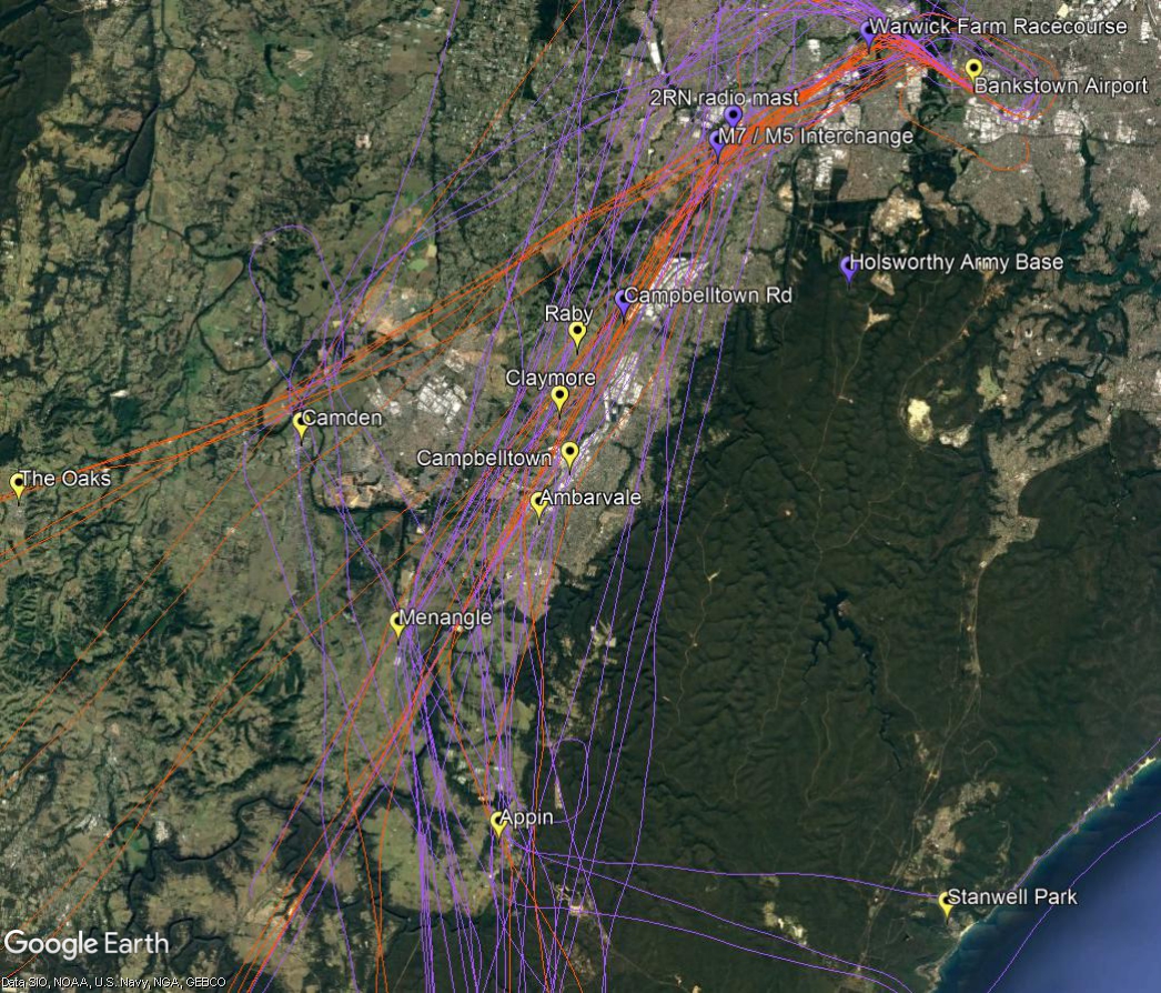
To and from the south and south-west
The image below shows actual aircraft tracks. Aircraft inbound to Bankstown Airport are coloured orange and outbound are purple.
From the south-west aircraft track towards Camden and then via the 2RN radio mast and the M7/M5 interchange and Warwick Farm Racecourse. From the south aircraft may track via Appin to Campbelltown Road and the 2RN mast.
If outbound to the south, aircraft will commence to climb to 2500 feet after passing the Liverpool to Parramatta railway line. The M7 motorway is a tracking feature for the turn to the south. Aircraft need to avoid restricted airspace around Holsworthy Army Base so will track towards Campbelltown and Appin. At Appin aircraft must be below 4500 feet to stay out of controlled airspace. If heading for the coast they will fly west of Appin then turn east towards Stanwell Park. By Stanwell Park aircraft must be at or below 2,500 feet to remain outside controlled airspace.
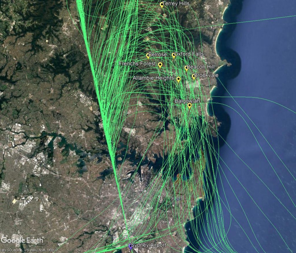
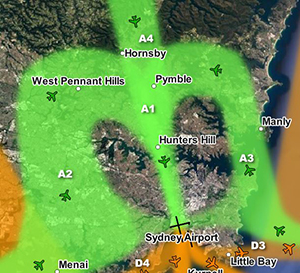
North-eastern suburbs of Sydney are overflown by aircraft travelling northwards to join the final approach to the parallel runways (flight path A3 in the image at right). This occurs when the parallel runways are being used in a southerly direction (“south flow”).
Aircraft on this flight path are being “vectored” by air traffic control. This means each aircraft is being given its own heading and altitude to allow it to intercept the final approach path, while maintaining safe separation from all the other aircraft around it.
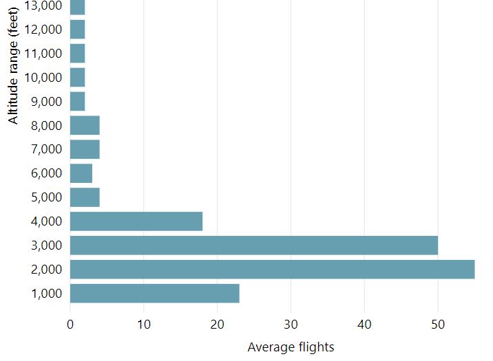
These aircraft are well into their descents for landing and are continuing to descend under air traffic control instructions. This means that the altitude of each aircraft will vary according to how far it has left to fly before intercepting the final approach and the altitudes of other aircraft in the area. Aircraft will generally intercept the final approach at around 3,000 feet in altitude.
The image below shows the actual tracks of aircraft being vectored to join the final approach. The image shows the spread of aircraft that is created by the act of vectoring. This spread is deliberate as it is part of the noise sharing strategy set out in the Long Term Operating Plan for Sydney Airport.