Learn about flight paths and aircraft movements in your area
Welcome to the Aircraft in Your Neighborhood Portal
Our goal is that you will learn more about the flight paths and aircraft movements in your area and be able to access the information and resources that explain how air traffic is managed.
First, please select your location using one of the following options, so that we can customize the information for your location.
We’ll remember your location so you don’t have to enter it every time you visit the site and we’ll keep this information confidential.
Please note, that this site works best on Chrome, Firefox and Edge.
* Mandatory - Select region first to view the map.
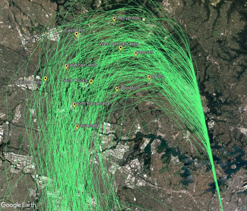
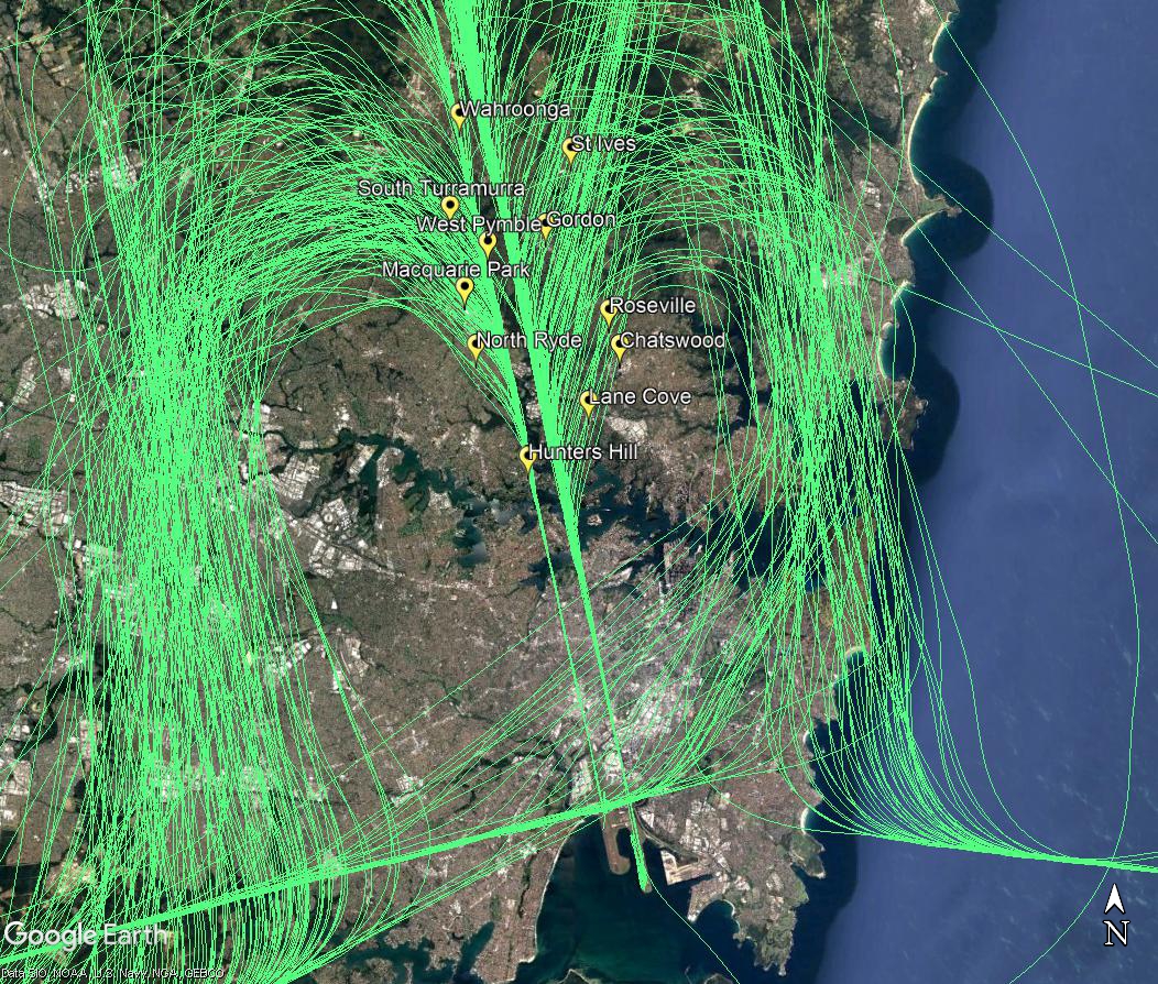
North-western suburbs of Sydney are overflown by aircraft travelling northwards to join the final approach to the parallel runways (flight path A2 in the image at right). This occurs when the parallel runways are being used in a southerly direction (“south flow”).
Aircraft on this flight path are being “vectored” by air traffic control. This means each aircraft is being given its own heading and altitude to allow it to intercept the final approach path, while maintaining safe separation from all the other aircraft around it.
These aircraft are well into their descents for landing and are continuing to descend under air traffic control instructions. This means that the altitude of each aircraft will vary according to how far it has left to fly before intercepting the final approach and the altitudes of other aircraft in the area. Aircraft will generally intercept the final approach at around 2500 to 3000 feet in altitude.
The image below shows the actual tracks of aircraft being vectored to join the final approach. The final approach path is the concentrated straight line at the bottom right of the image. This path leads directly to the runway. The image shows the spread of aircraft that is created by the act of vectoring. This spread is deliberate as it is part of the noise sharing strategy set out in the Long Term Operating Plan for Sydney Airport.
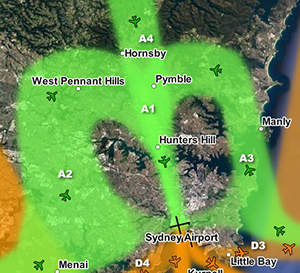
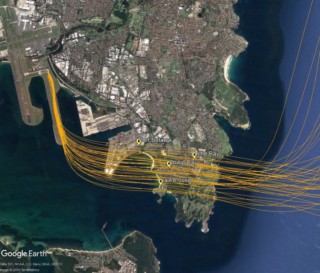
When the parallel runways are being used in a southerly direction (“south flow”), aircraft that arrive into Sydney from the south, east and west need to travel northwards to join the final approach path from the north. As they travel northwards some will pass over the eastern suburbs (labelled A3 in the image).
Aircraft travelling to join the final approach are being “vectored” by air traffic control. This means each aircraft is being given its own heading and altitude to allow it to intercept the final approach path (A1 in the image), while maintaining safe separation from all the other aircraft around it.
These aircraft are continuing to descend for landing under air traffic control instructions. This means that the altitude of each aircraft will vary according to how far it has left to fly before intercepting the final approach and the altitudes of other aircraft in the area. Aircraft will generally intercept the final approach at around 3,000 feet in altitude. When they are over the eastern suburbs they generally will be within the range of 6,000 to 7,500 feet in altitude.
The image below shows the actual tracks of aircraft being vectored over the eastern suburbs. These show the spread of aircraft that is created by the act of vectoring. This spread is deliberate as it is part of the noise sharing strategy set out in the Long Term Operating Plan for Sydney Airport.
The eastern suburbs are affected by aircraft departing from the easternmost parallel runway (Runway 34 Right) and arriving to the east-west runway (Runway 25). Occasionally there will also be departures from the east-west runway (Runway 07) but this is relatively infrequent.
Departures from the parallel runway: north flow
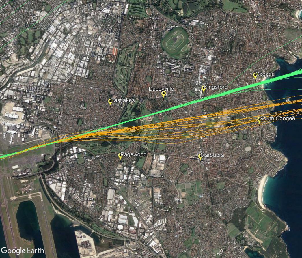
When the parallel runways are being used in a northerly direction, (“north flow”), most aircraft departing the easternmost parallel runway turn to the east or north-east after take-off. Aircraft that turn east are bound for destinations to the east and south. They will pass over suburbs including Kingsford and Maroubra.
Aircraft using this flight path begin their turns when they reach 500 feet in altitude. As different types of aircraft have different climbing abilities, they will reach this altitude at different points after take-off and therefore begin their turns at different points in the air. This has the effect of creating a spread of aircraft. This spread can be seen in the image below which shows actual tracks of aircraft on this flight path.
Departures from the parallel runway: south flow
When the parallel runways are being used in a southerly direction (“south flow”), non-jet aircraft that take off from the easternmost parallel runway turn left after departure. They turn immediately after take-off in order to ensure they remain separated from the faster jet traffic which proceeds through the heads.
Non-jets using this flight path are heading primarily to northern destinations such as Armidale, Taree, Coffs Harbour and Port Macquarie. After their initial eastward turn they will then turn north towards these destinations.
The image below shows the actual tracks of non-jet aircraft using this flight path.
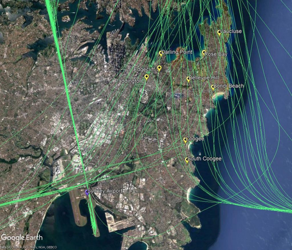
Arrivals to and departures from the east-west runway: west flow and east flow
In “west flow” the east-west runway is used for arrivals. Arriving aircraft must align with the runway from a considerable distance out from the airport, and fly straight in. This means that aircraft arriving to land during this runway configuration will always fly over suburbs such as Coogee, Randwick, Kingsford, Daceyville and Eastlakes.
Sydney’s seasonal wind patterns are such that the east-west runway tends to be used for arrivals more frequently in the cooler months that at other times of the year. At this time of year it is not unusual for Sydney to experience strong westerly winds. In these conditions there is often too much crosswind on the parallel runways, meaning that they cannot be safely used. When this occurs, all traffic may need to use the east-west runway for prolonged periods of time. This usually results in delays at the airport because the usual throughput of flights cannot be attained when using only one runway.
It is relatively unusual for aircraft to depart towards the east from the east-west runway, (“east flow”), but it does occur on occasion when the wind is a strong easterly. As explained above, in these conditions it may mean that the parallel runways cannot be used, resulting in all traffic departing towards the west.
The following image shows the actual tracks of arrivals to the east-west runway in green and departures in orange.
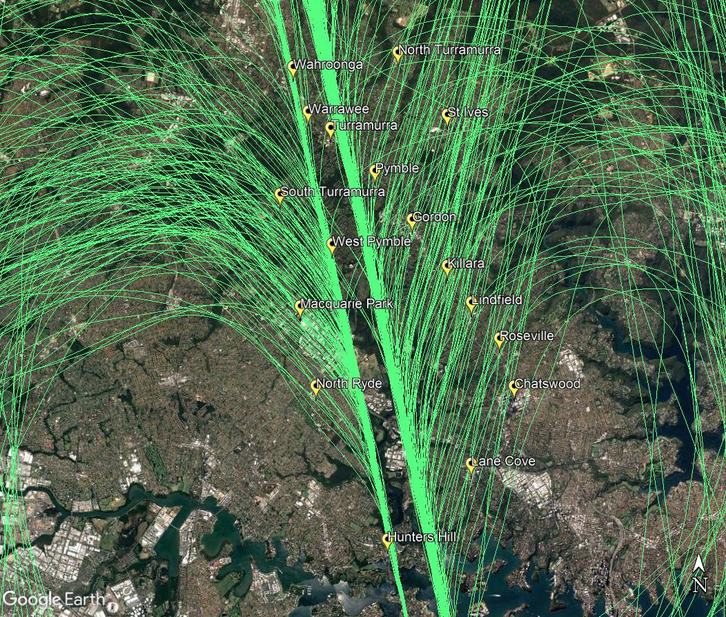
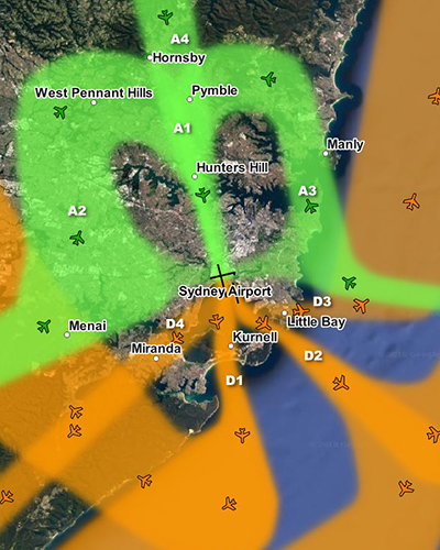
Suburbs to the north of the airport are affected by aircraft arriving to the parallel runways when they are being used in a southerly direction, (“south flow”) as shown by the flight paths labelled A1, A2, A3 and A4 in the image, right.
Arriving aircraft must align with the runway from a considerable distance out from the airport, and fly straight in. The aircraft that fly over the northern suburbs are either travelling to align with the runway and join the final approach (flight paths A2, A3 and A4), or are already lined up with the runway and on the final approach (A1).
Aircraft travelling to join the final approach are being “vectored” by air traffic control. This means each aircraft is being given its own heading and altitude to allow it to intercept the final approach path, while maintaining safe separation from all the other aircraft around it.
These aircraft are well into their descents for landing and are continuing to descend under air traffic control instructions. This means that the altitude of each aircraft will vary according to how far it has left to fly before intercepting the final approach and the altitudes of other aircraft in the area. Aircraft will generally intercept the final approach at around 3000 feet in altitude.
While it might seem like the northern suburbs are a long way from the airport, in aviation terms they are relatively close. For example, the flying time to the runway from Wahroonga is less than five minutes, and less than three minutes from Hunters Hill.
The images below show the actual tracks of aircraft arriving over the northern suburbs. These show the spread of aircraft that is created by the act of vectoring. This spread is deliberate as it is part of the noise sharing strategy set out in the Long Term Operating Plan for Sydney Airport.
The first image is zoomed in on your area:
The next image is zoomed out to show the approach all the way to the runways.
Weather, in particular wind speed and direction, is generally the main factor in determining which runways are in use at an airport, in which direction aircraft will take off and land and which flight paths are used.
At all times, the safe operation of aircraft will be the primary consideration.
Runway naming
Runways are named using a numbering system which reflects the runways’ orientation. The number, between 01 and 36, correlates to the degrees on a compass, for example:
A runway numbed 09 points east at 90 degrees
A runway numbered 27 points west at 270 degrees.
Some airports will have additional runways side-by-side, in this case the letters, left, right and even center are used to differentiate the different runways.
Runway use
Runways can be used in both directions and a runway will have a different name to refer to each end. In the above example the runway runs east-west, with runway 09 pointing east and 27 pointing west.
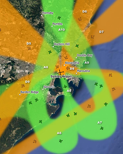
The inner suburbs of Sydney are affected by aircraft arriving to and departing from the parallel runways at Sydney Airport in “south flow” and “north flow”.
Below: south flow (left) and north flow (right)
Arrivals – south flow
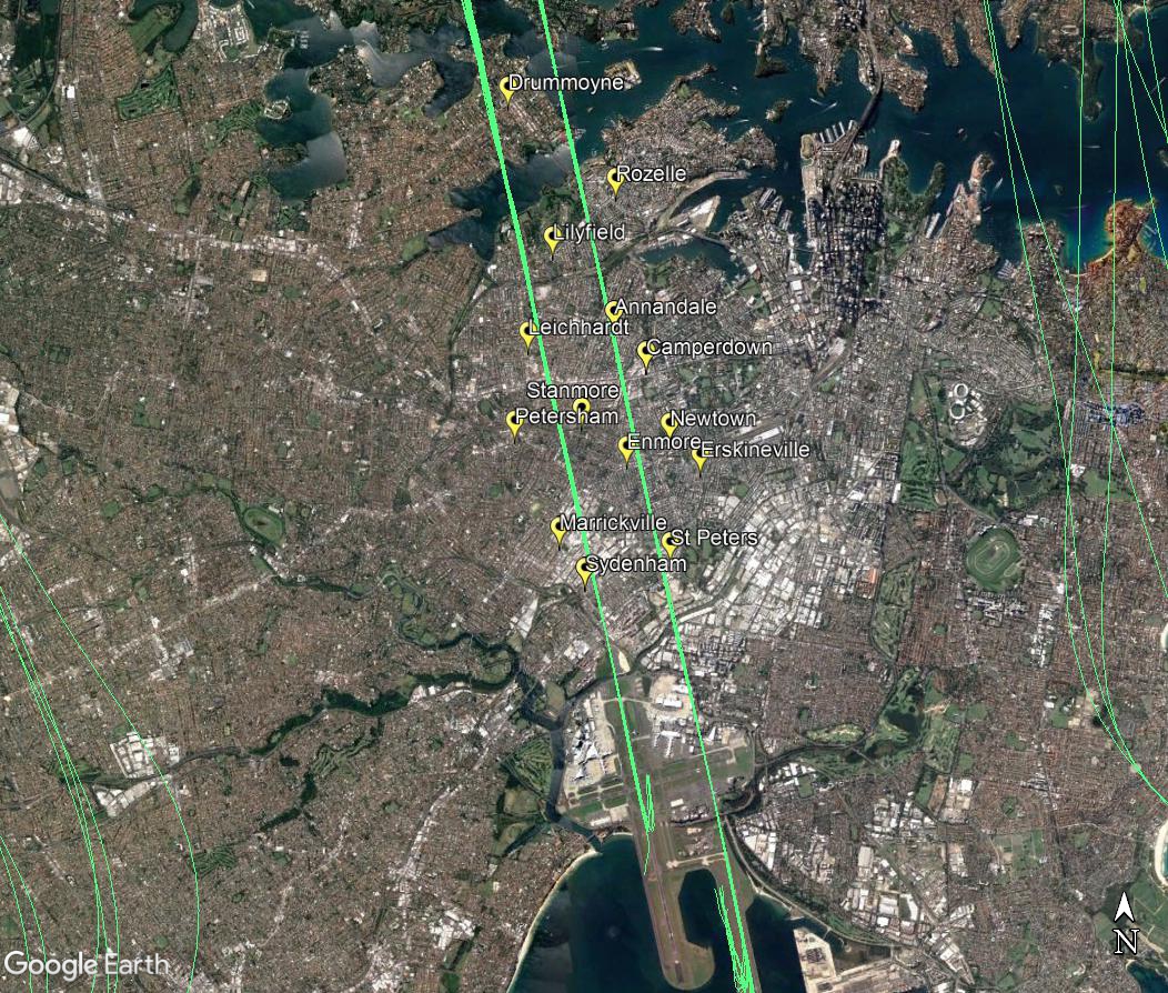
Arriving aircraft must align with the runway from a considerable distance out from the airport, and fly straight in. This flight path is labelled A1 in the top left image. When the parallel runways are used in a southerly direction, (south flow), this means that aircraft on their final approach to land on the easternmost parallel runway (Runway 16 Left) will always fly over suburbs such as Rozelle, Annandale, Camperdown, and Newtown, and those arriving to the westernmost parallel runway (Runway 16 Right) will fly over Lilyfield, Leichhardt, and Stanmore, for example. The image below shows actual tracks of arriving aircraft.
Departures – north flow
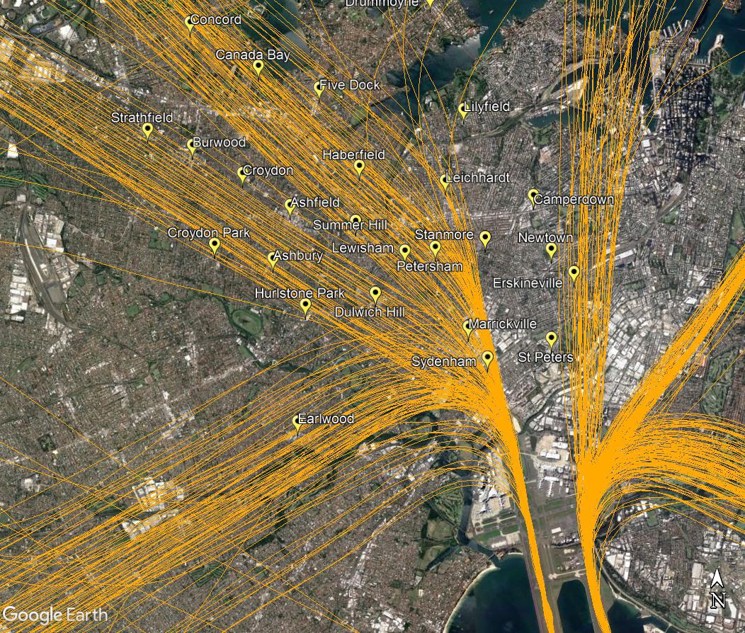
When the parallel runways are being used in a northerly direction, (north flow), jet aircraft departing from the westernmost parallel runway (Runway 34 Left) will begin to turn to their heading when they reach 800 feet or 1,500 feet, depending on which track they are taking. As different types of aircraft have different climbing abilities, they will reach these altitudes at different points after take-off and therefore begin their turns at different points in the air. This has the effect of creating a spread of aircraft as can be seen in the image of actual departure tracks below. This flight path is labelled D5 in the image at top right.
Non-jets follow a different procedure and turn very early after take-off before proceeding to the south-west to destinations such as Canberra. This flight path is labelled D9 in the image above right.
This image below shows the actual tracks of departing aircraft:
Most aircraft departing the easternmost parallel runway (Runway 34 Right) turn to the east or north-east after take-off, avoiding the inner west. However non-jets bound for northerly destinations will continue straight ahead after take-off, passing over suburbs such as Newtown, Erskineville, Glebe and Pyrmont (labelled D6 in the image at top right). By the time they reach Pyrmont they will generally be within the altitude range of 2,500 to 4,000 feet.
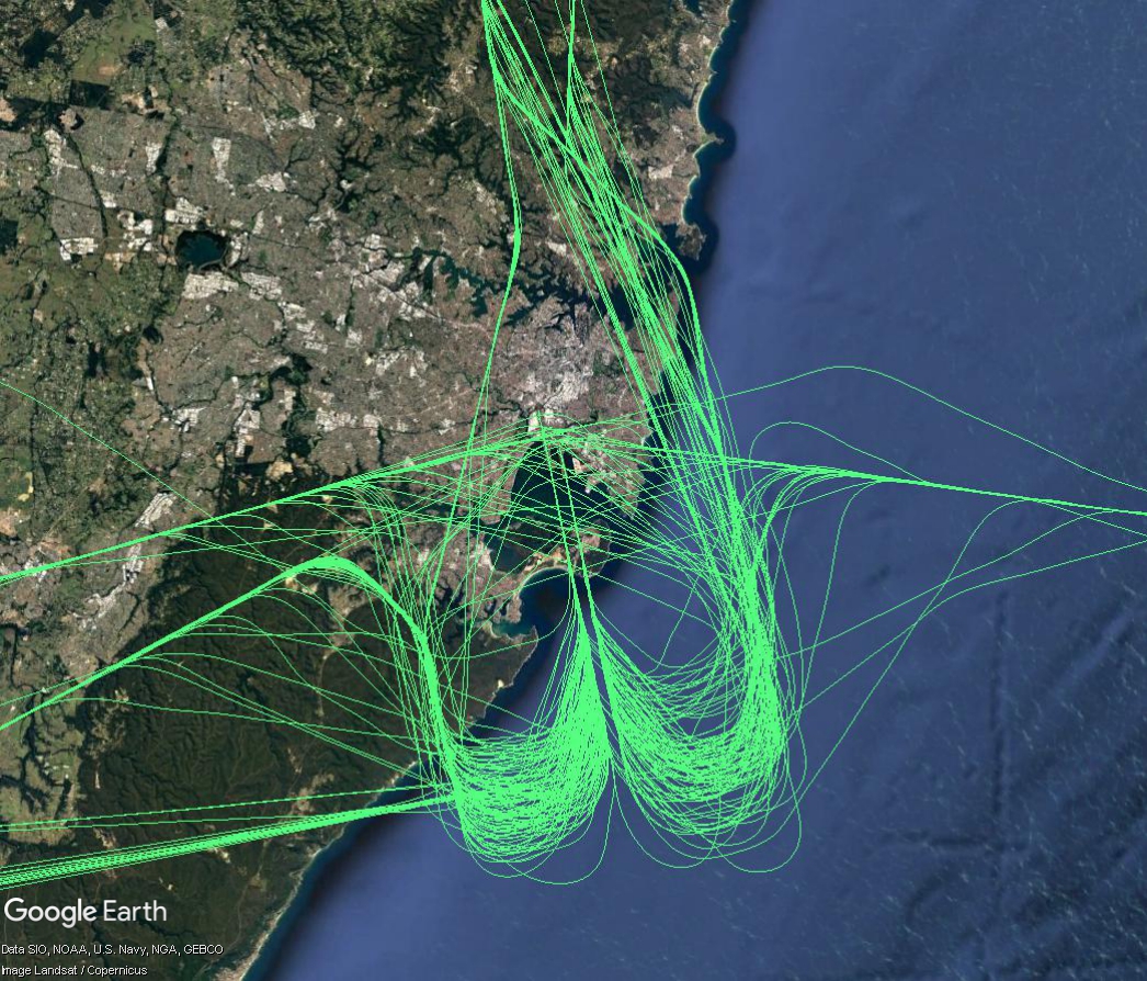
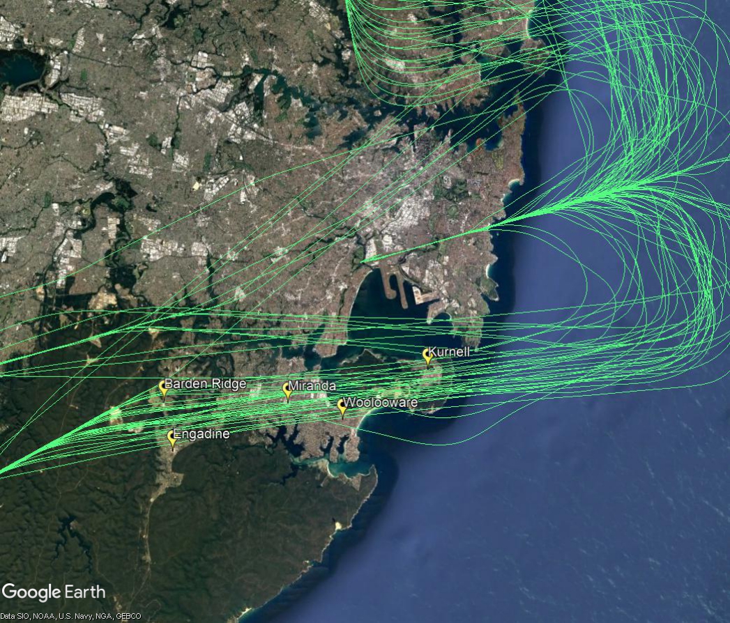
When the parallel runways are being used in a northerly direction, (“north flow”), arriving aircraft will pass over suburbs in the Sutherland Shire and nearby areas as they make their way to join the final approach from over water, south of Sydney. In north flow, aircraft that are approaching Sydney from the north, west, east and south-west must be directed by air traffic controllers into an orderly landing sequence. The image below of actual aircraft tracks illustrates this complex arrival procedure.
Arrivals from the north
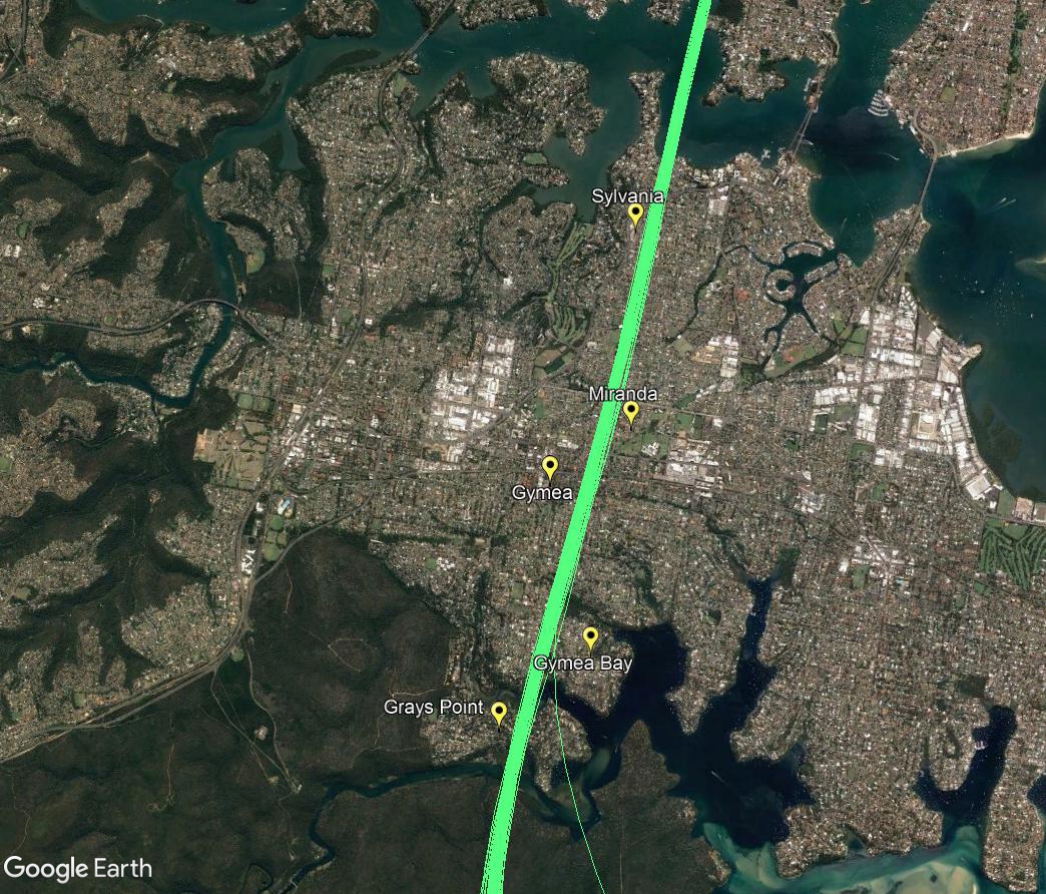
Aircraft that arrive into Sydney from northern ports need to travel southwards across the city to join the final approach that begins over water. Aircraft using this flight path will generally be at altitudes within the range of 5,000 to 7,000 feet when they pass over suburbs such as Sylvania, Miranda and Gymea.
The image below is zoomed in and filtered to show only these arrivals travelling from the north to the south.
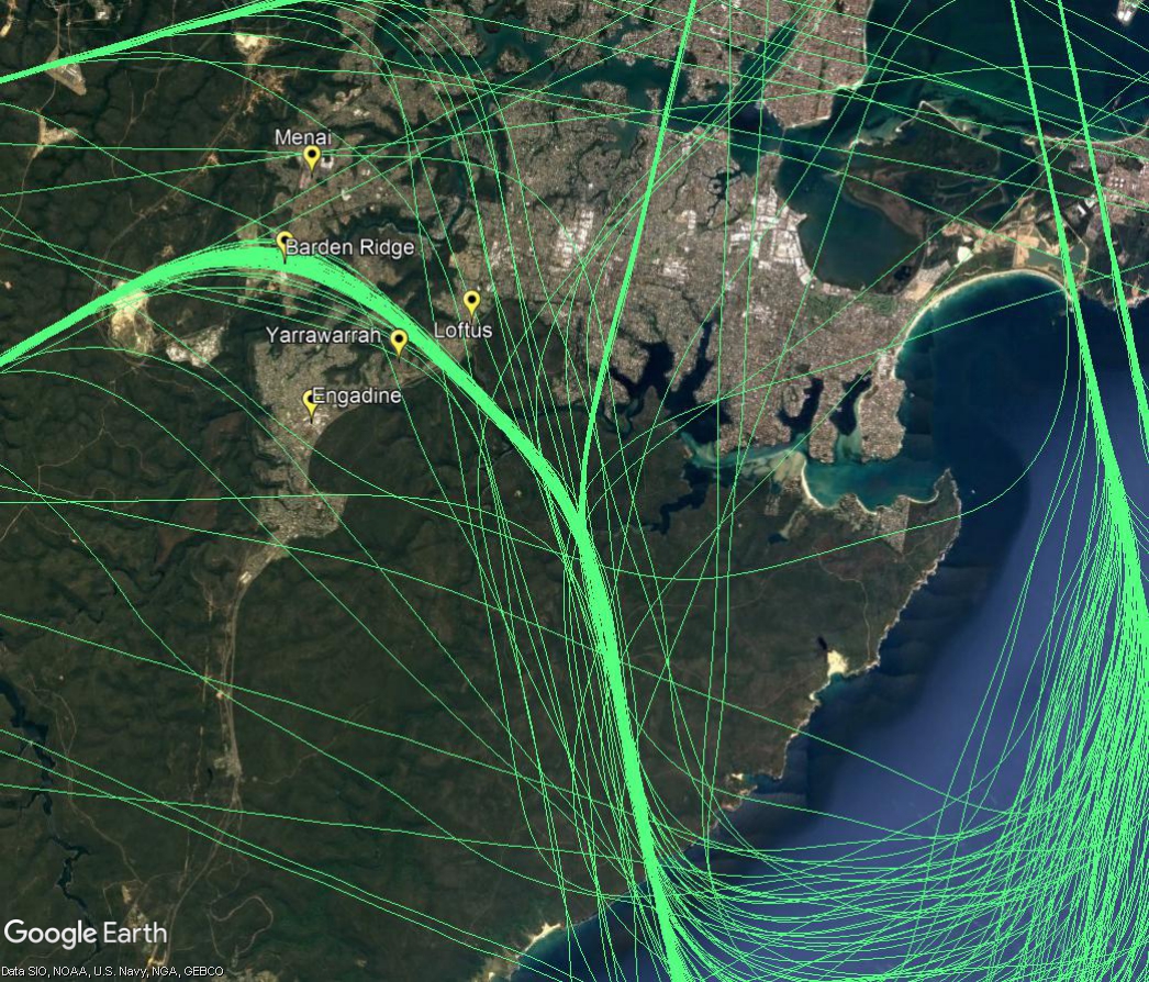
Arrivals from the south-west and west
Aircraft arriving into Sydney from the south-west will pass over suburbs such as Barden Ridge and Yarrawarrah before turning southwards and flying over the Royal National Park to cross the coast, as shown in the image below. Aircraft coming from the west will turn southwards over suburbs such as Illawong, Bangor, Jannali and Loftus as they too head towards the coast. All these aircraft will be generally within the altitude range of 6000 to 8,000 feet.
Final approach
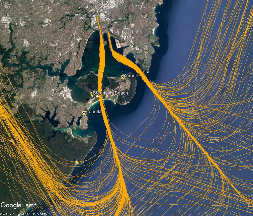
The final approach paths are adjacent to Kurnell and Greenhills Beach. When they intercept the final approach aircraft will be at altitudes of around 3,000 feet and will continue to descend steadily to the runway. Aircraft landing on the easternmost runway will be at an altitude of around 1,000 feet when adjacent to Kurnell, while those landing on the westernmost runway will be around 1,200 feet as they have slightly further to fly before touching down.
South flow
When the parallel runways are being used in a southerly direction, (“south flow”), jet aircraft departures will be seen and heard by residents in suburbs such as Kurnell, Greenhills Beach and Cronulla. The image below shows the actual tracks of departing jets on this flight path.
In south flow, non-jet aircraft that take off from the westernmost parallel runway will turn right after departure over suburbs in the Sutherland Shire.
Non-jets turn immediately after take-off in order to ensure they remain separated from the faster jet traffic which continues straight ahead.
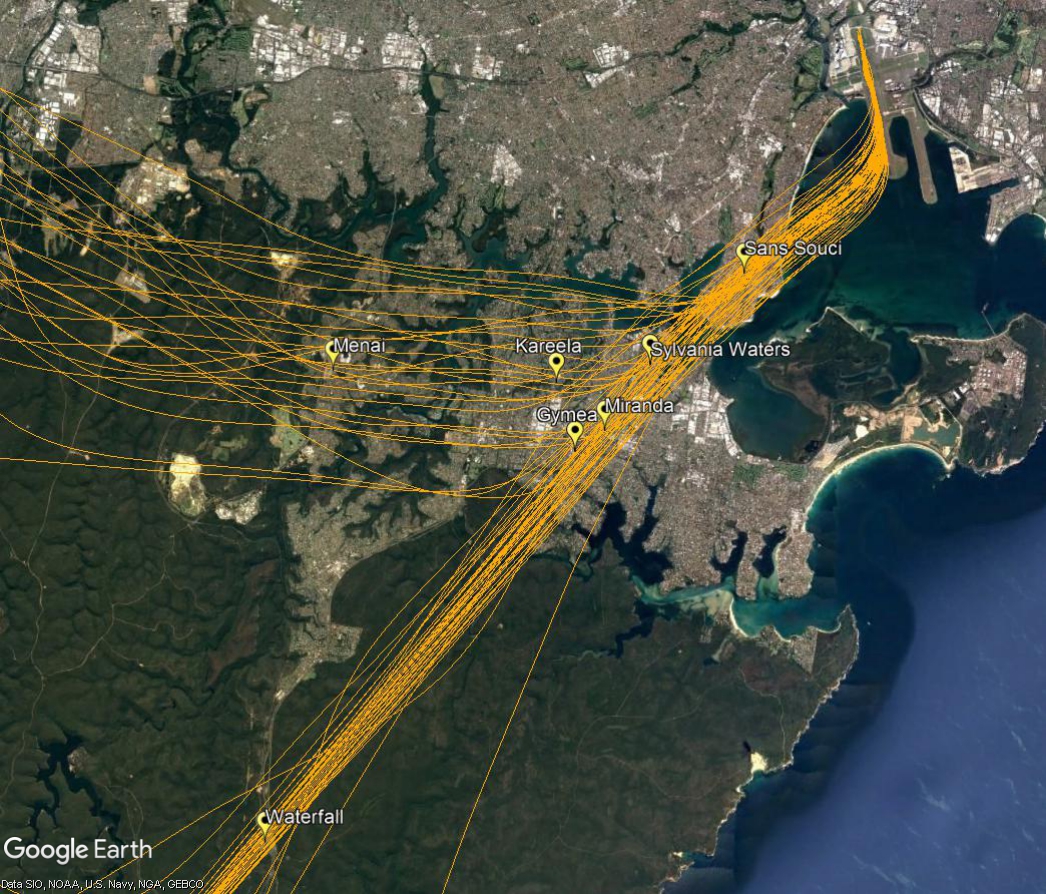
The image below shows the actual tracks of non-jet aircraft using this flight path. Non-jets heading in a south-westerly direction are bound for destinations such as Canberra, Albury, Wollongong and the south coast. Others heading to destinations such as Bathurst, Orange and Dubbo and Mudgee turn west and north-west after their initial south-westerly turn.
East and west flow
When the east-west runway is being used, some aircraft will fly over the Shire as they travel to join the final approach. These aircraft generally will be between 6,000 and 8,000 feet with most over 7,000 feet. This flight path is shown in the image below.
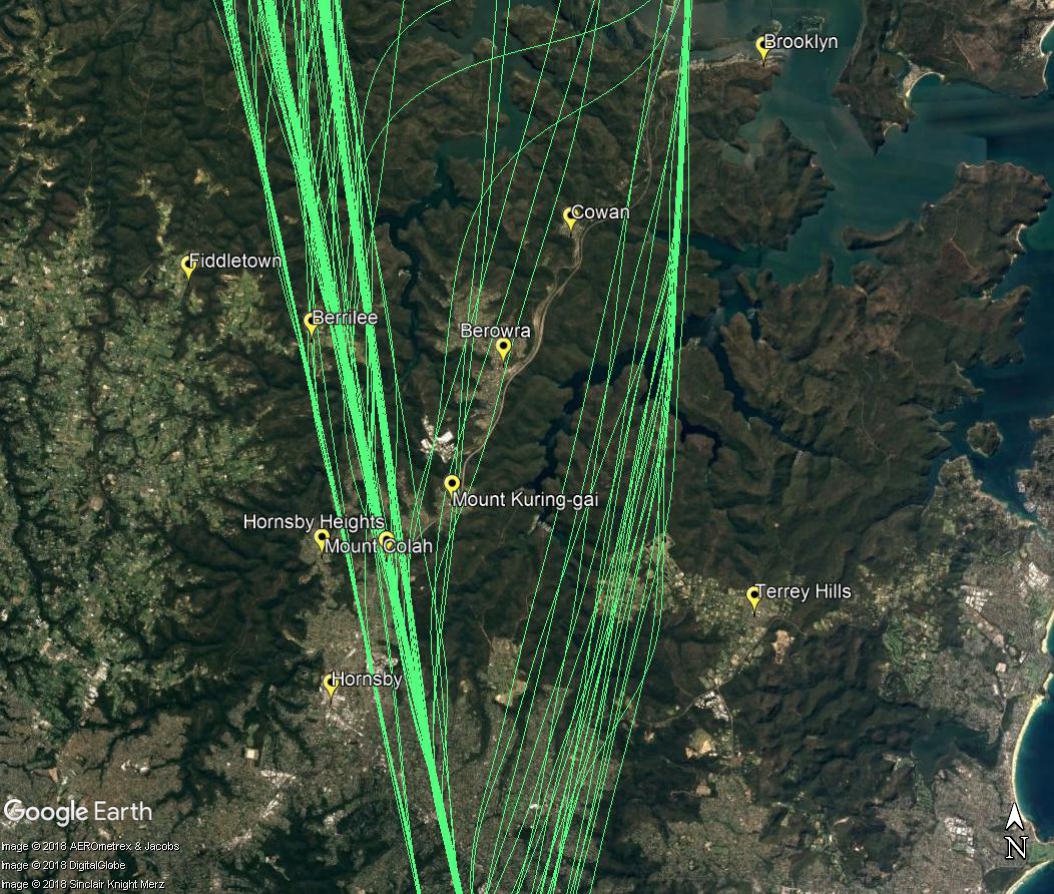
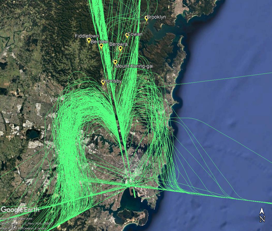
Suburbs to the north of the airport are affected primarily by aircraft arriving to the parallel runways when they are being used in a southerly direction, (“south flow”), as shown by the flight paths labelled A1, A2, A3 and A4 in the image, below
Arriving aircraft must align with the runway from a considerable distance out from the airport, and fly straight in. The aircraft that fly over the northern suburbs are either travelling to align with the runway and join the final approach (flight paths A2, A3 and A4), or are already lined up with the runway and on the final approach (A1).
These aircraft are well into their descents for landing and are continuing to descend under air traffic control instructions. This means that the altitude of each aircraft will vary according to how far it has left to fly before intercepting the final approach and the altitudes of other aircraft in the area. Aircraft will generally intercept the final approach at around 3000 feet in altitude. In the vicinity of Berrilee aircraft will be generally within the altitude range of 5,000 to 7,000 feet if landing on the easternmost runway or between 5,000 and 6,000 feet if landing on the closer westernmost runway.
While it might seem like the northern suburbs are a long way from the airport, in aviation terms they are relatively close. For example, the flying time to the runway from Hornsby is around five minutes.
The images below show the actual tracks of aircraft arriving over suburbs to the north of Sydney.
The first image is zoomed in on your area:
The next image is zoomed out to show the approach all the way to the runways.
Each year we manage domestic and international air traffic operations for over 140 million passengers on more than four million aircraft movements in a region covering 11 per cent of the world’s surface. The following video shows what 24 hours of operations looks like:
Controlled and uncontrolled airspace
Airspace is designated as either:
Controlled airspace which is actively managed by air traffic controllers and is broken up into a number of different classes or classifications. To enter controlled airspace, an aircraft must first gain a clearance from air traffic control.
Uncontrolled airspace which requires no clearance (or supervision by air traffic control) to operate. The large majority of light aircraft and helicopters operate outside or underneath controlled airspace (for example, aircraft that operate at low levels over Sydney Harbour).
Terminal Airspace
Terminal airspace is the controlled airspace surrounding a major airport, generally within a 30–50 nautical miles (55–90 kilometres) radius. In the case of some major airports, this airspace extends from ground level up to 18,000 feet (approximately 6,000 metres).
As the distance from the airport increases, the lower boundary of this airspace rises in steps, enabling other airspace users (such as gliders and balloons) to operate outside terminal airspace without requiring an air traffic clearance.
Restricted Airspace & No fly zones
In restricted airspace, aircraft movements are restricted in accordance with certain specified permissions. Examples of restricted airspace include airspace around military installations and high density flying operations at an air show or other large public event.
Restricted airspace may be imposed by police for safety or security reasons in the vicinity of bushfires or major crime scenes. Decisions on restricted airspace are made by the Civil Aviation Safety Authority.
No-fly zones are similar to restricted airspace but are imposed and enforced by the military (usually the Royal Australian Air Force). No-fly zones will often be established around military exercises, heads of government meetings and major events such as the Olympic or Commonwealth Games. Airservices has no authority or control over no-fly zones.
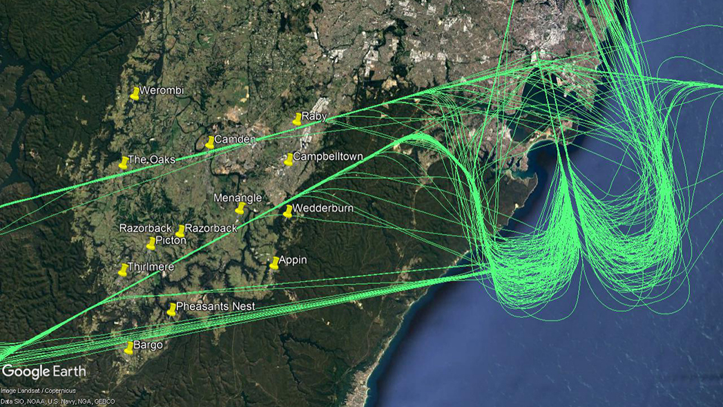
Arriving aircraft into Sydney from ports to the south-west and west will pass over your area as they travel to land at Sydney Airport.
Aircraft arriving from the west will fly near townships and suburbs such as The Oaks, Camden and Raby, while those arriving from the south-west will pass by areas such as Thirlmere, Menangle and Campbelltown.
As these aircraft arrive into the Sydney basin they are at average altitudes of 11,500 feet at Oakdale and 12,500 feet at Thirlmere, with the lowest around 9,000 feet and the highest around 15,000 feet. As they travel they continue to descend, and by the time they reach the western boundary of the Holsworthy area they average 6,500 feet.
The image below shows actual tracks of arriving aircraft.