Sydney Airport arrivals – south flow

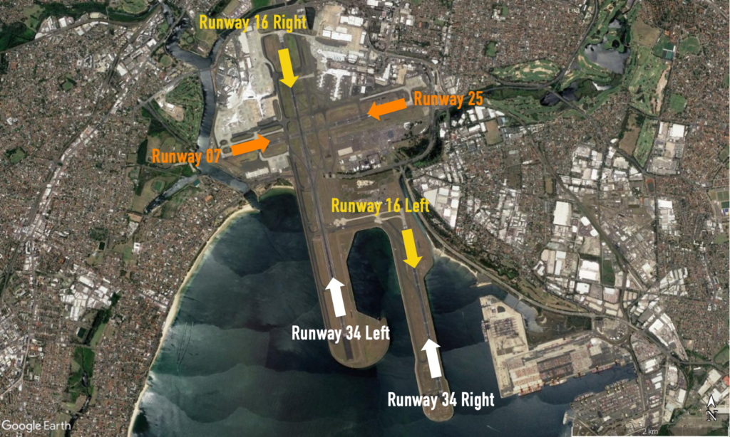
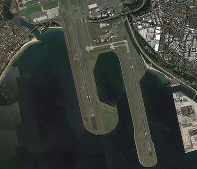
Suburbs to the north of the airport are affected primarily by aircraft arriving to the parallel runways when they are being used in a southerly direction, (“south flow”), as shown by the flight paths labelled A1, A2, A3 and A4 in the image, below

Flight path

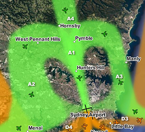
Arriving aircraft must align with the runway from a considerable distance out from the airport, and fly straight in. The aircraft that fly over the northern suburbs are either travelling to align with the runway and join the final approach (flight paths A2, A3 and A4), or are already lined up with the runway and on the final approach (A1).

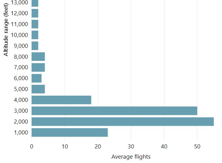
These aircraft are well into their descents for landing and are continuing to descend under air traffic control instructions. This means that the altitude of each aircraft will vary according to how far it has left to fly before intercepting the final approach and the altitudes of other aircraft in the area. Aircraft will generally intercept the final approach at around 3000 feet in altitude. In the vicinity of Berrilee aircraft will be generally within the altitude range of 5,000 to 7,000 feet if landing on the easternmost runway or between 5,000 and 6,000 feet if landing on the closer westernmost runway.

While it might seem like the northern suburbs are a long way from the airport, in aviation terms they are relatively close. For example, the flying time to the runway from Hornsby is around five minutes.

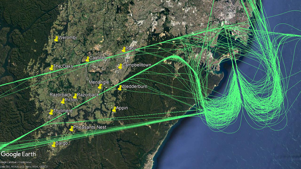
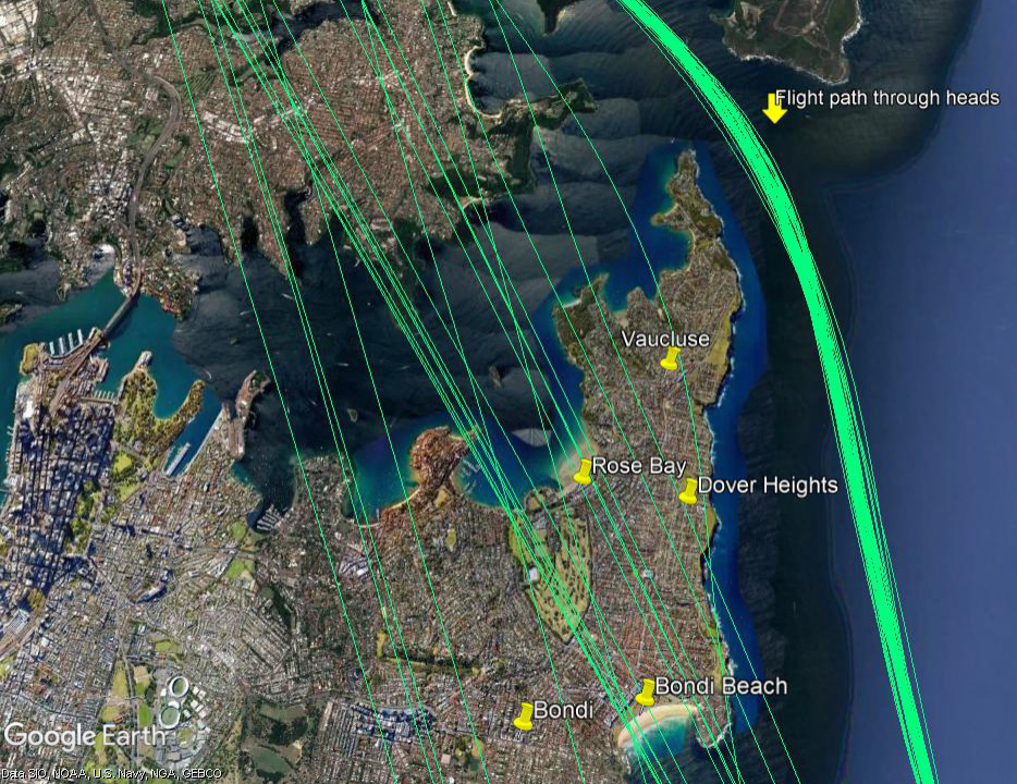
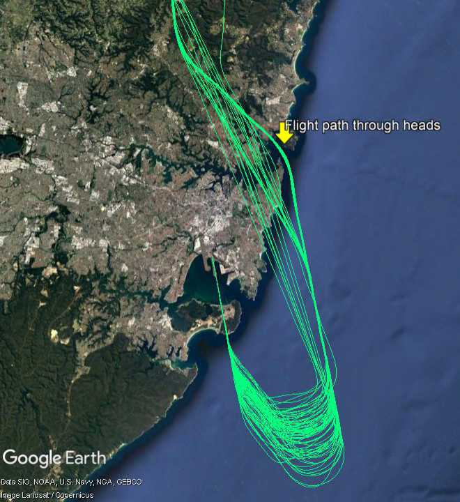
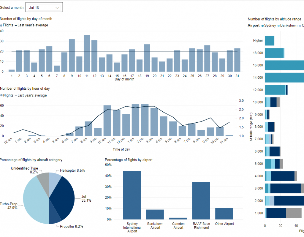
The images below show the actual tracks of aircraft arriving over suburbs to the north of Sydney.

The first image is zoomed in on your area:
Northern suburbs

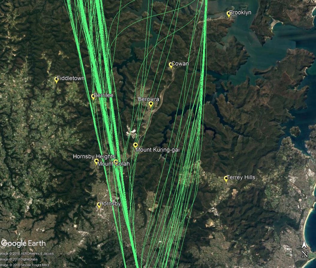
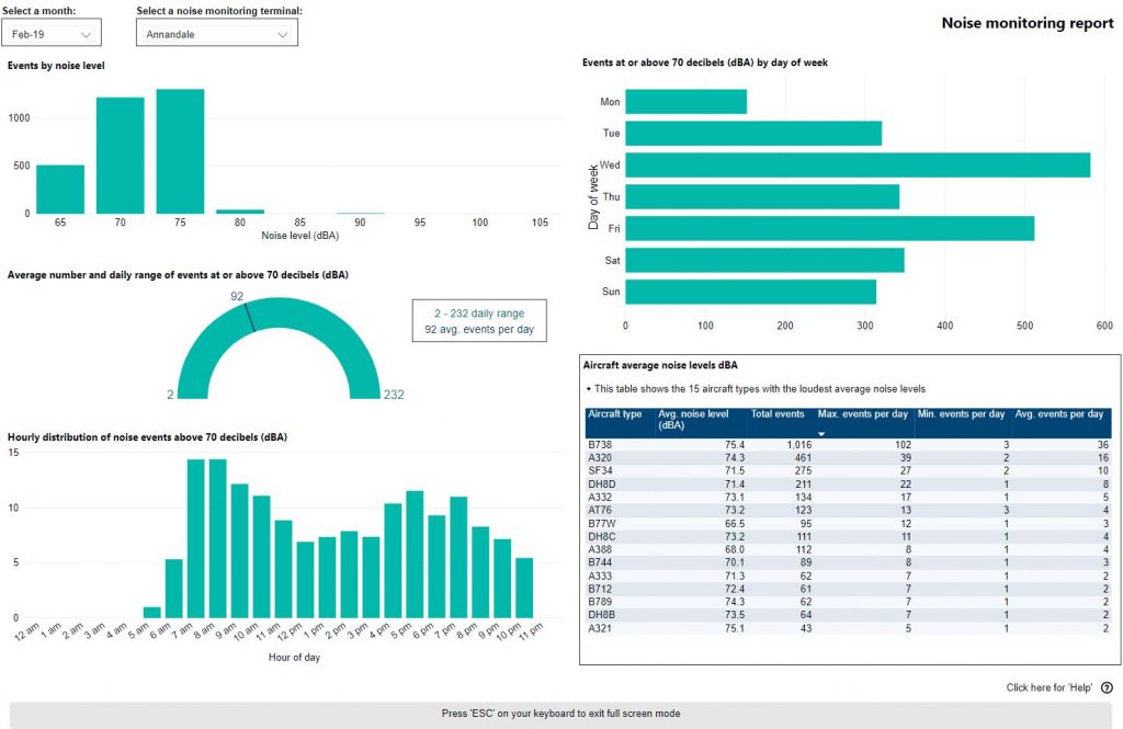
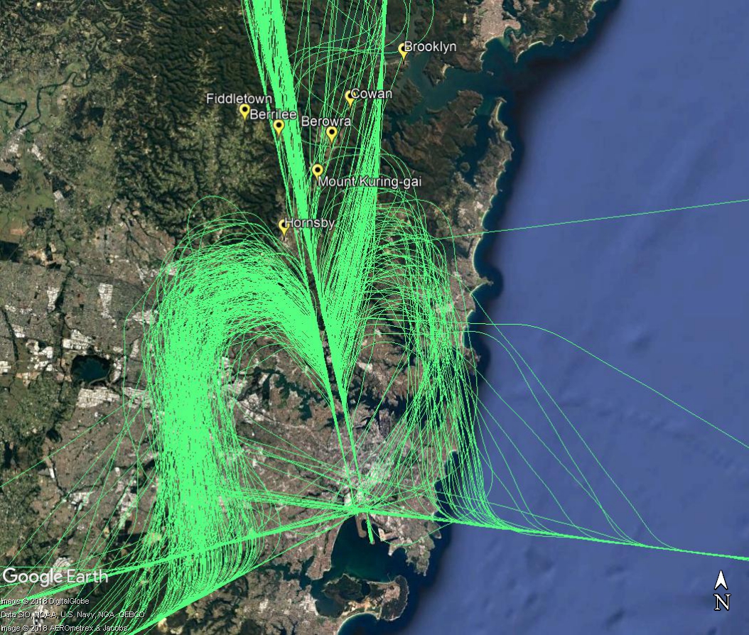
The next image is zoomed out to show the approach all the way to the runways.

Wide view of approach from the north

Learn more about noise sharing and the Long Term Operating Plan

Sydney Airport arrival flight paths

Arriving aircraft into Sydney from ports to the south-west and west will pass over your area as they travel to land at Sydney Airport.

Aircraft arriving from the west will fly near townships and suburbs such as The Oaks, Camden and Raby, while those arriving from the south-west will pass by areas such as Thirlmere, Menangle and Campbelltown.

As these aircraft arrive into the Sydney basin they are at average altitudes of 11,500 feet at Oakdale and 12,500 feet at Thirlmere, with the lowest around 9,000 feet and the highest around 15,000 feet. As they travel they continue to descend, and by the time they reach the western boundary of the Holsworthy area they average 6,500 feet.

The image below shows actual tracks of arriving aircraft.

Arrivals from the south-west and west

Sydney Airport Runways

Sydney Airport has three runways. Each runway can be used in two directions. Because flight paths are linked to runways, the runway in use and the direction in which it is used determines which flight paths are used at any given time. When the runway in use changes, the flight paths in use will also change, and different sections of the community will experience overflights.

Each runway is referred to differently according to in which direction it is being used, as explained in the following video:

For example the main runway is known as Runway 34 Left (34L) when used in a northerly direction and Runway 16 Right (16R) when used in a southerly direction. Runway numbering reflects the runways’ orientation and correlates with degrees on a compass. For example, Runway 34L is 340 degrees.

The main runway 16R/34L (3.9km) is orientated north to south, as is a shorter parallel runway 16L/34R (2.4km long). The cross runway 07/25 (2.5km) is orientated east to west.

Heavy long-haul jets, such as Airbus 380s, and Boeing 747s, 777s and 787s will usually use Runway 34L/16R because it is the longest runway and they need the extra length.

Air traffic controllers select which runways to use based on wind direction, weather conditions, traffic volume and other factors. Because aircraft take-off and land into the wind for safety and performance reasons, the wind conditions at the airport are a key factor in these decisions. If the wind at the airport is calm or light, other factors are taken into account. These factors are discussed in more details in our Runway Selection page.

The Sydney Airport Long Term Operating Plan also informs runway selection decisions. Learn more about the Long Term Operating Plan and noise sharing.

Sydney Airport has a curfew that restricts both aircraft type and runway usage between the hours of 11:00 pm and 6:00 am. During this time departures use Runway 16R and arrivals 34L. Emergency medical flights are excepted and can use any runway required to expedite their journey.

Investigate flight path usage in your area

WebTrak My Neighbourhood (left) is an extension of WebTrak that presents historical information about aircraft noise and flight path use to provide an understanding of patterns over time.

Using this tool you can explore arrival, departure or both types of flight paths by month, quarter or year to see:

  • the percentage of traffic on each flight path
  • the number of aircraft that used the flight path
  • the number of hours the flight path was not used
  • weekday and weekend use
  • day, evening and night-time use
  • noise monitoring data

Access information about how to use WebTrak My Neighbourhood, including a downloadable guide

Visit WebTrak My Neighbourhood – Sydney

Below: a departure flight path ‘swathe’ with tag showing percentage of departure traffic, number of flights and hours of respite for that flight path in the selected timeframe

Below: Click the “i” on any flight path tag to see more detailed data

Below: noise monitoring data tags

When is each flight path used?

Each runway in use at an airport has its own set of flight paths, and each flight path will affect different areas. As the runway in use changes, the flight paths in use will change, and so too do the suburbs affected by aircraft movements.

The runway in use at any given time and the direction of the traffic flow will vary primarily according to the wind conditions at the airport. This is because aircraft must take off and land into the wind for safety reasons. Generally, this means that in:

  • Northerly wind conditions at the airport (including north-westerlies and north-easterlies), north flow will be used.
  • Southerly wind conditions at the airport, including south-westerly and south-easterly conditions, south flow will be used.

However at times a runway direction may be used with a small amount of tailwind as long as it does not exceed the Civil Aviation Safety Authority’s limits for downwind (tailwind) and crosswind.

When the wind at the airport is calm or light, other factors are taken into account in selecting the runway that will be used. For example, the location of the terminals and the positioning of the taxiways can influence the decision.

At Sydney Airport, the proximity of the terminals to the northern end of the westernmost parallel runway means that in busy periods when south flow is being used, there is not always enough space on the taxiways between the terminals and the runway end for all the waiting aircraft to queue for take-off.

To manage this, some aircraft may need to be held at the departure gate until space becomes available. This can result in delays and create knock-on effects around the country. For this reason, if the wind is not a factor in the decision, north flow will usually be preferred over south flow during peak periods.

Location of terminals at Sydney Airport
Southern end

The proximity of the terminals to the runway at northern end of Sydney Airport means there is limited space on the taxiways for queuing. Below right: There is much more room for queuing aircraft on the taxiways at the southern end of the Airport.

Our page on Runway Selection discusses how decisions are made about which runway to use.

Sydney Airport – Traffic management of arrivals from the north

There is a flight path for aircraft arriving into Sydney from northern ports that brings aircraft through the Sydney heads and southwards down the coast, over water, to arrive on the easternmost parallel runway. This flight path is used when the parallel runways are being used in a northerly direction (“north flow”).

There are times when air traffic controllers need to take aircraft off this flight path to ensure they remain safely separated from other traffic and/or can be efficiently sequenced with aircraft arriving from the east, south and west for landing. When there is poor weather, or in peak periods when there is a high volume of traffic in the airspace, this is more likely to occur.

The image at right shows actual tracks of aircraft arriving into Sydney from the north and travelling southwards to land on the easternmost parallel runway.

When aircraft are diverted from the usual flight path they must be directed over land, and will pass over suburbs such as Rose Bay, Dover Heights and Point Piper. It is not possible to divert these aircraft further east, over the water, because this would create potential conflicts with aircraft that are departing from the easternmost parallel runway and heading north-east. The conflicts could occur because the departures and the arrivals would be at similar altitudes when their paths crossed.

The image below is a zoomed in view of the tracks of aircraft arriving from the north. Aircraft on the usual flight path can be seen flying through the heads and down the coast over water. Aircraft that have been taken off the normal flight path can be seen flying over land.

Traffic management - arrivals from the north

Aircraft taken off the usual flight path will generally be in the altitude range of 6,000 to 8,000 feet as they pass over the eastern suburbs. This is around twice as high as the jet aircraft that depart over the area.

Air traffic controllers are aware of potential noise implications for the community and do not take aircraft off standard routes unless it is operationally necessary. Unfortunately, when operationally required, this cannot be avoided.

How frequent are flights in my area?

There are a number of factors that influence the frequency of flights.

Firstly, the number and frequency of flights will vary on a daily, weekly and yearly basis due to differences in airline schedules. The airlines schedule flights in response to consumer demand. This is particularly the case around Christmas, Easter, school holidays and Lunar New Year.

Secondly, the runway in use at any given time will also vary, largely due to the wind conditions. Each runway has its own set of flight paths, and each flight path will affect different areas. As the runway in use changes, the flight paths change, and so too do the areas affected by aircraft movements.

This chart shows the total number of flights each hour over the month, compared to the average for last year. Change the selected month to see how it has varied.

*Please note due to technical issues between 19 June and 22 June 2024, flight data may not be accurately displayed. Our supplier is working to resolve the issue. We apologise for any inconvenience this may cause.

How high are aircraft near me?

The altitudes of aircraft over your area can vary according to:

  • the airport the flight is coming from or going to
  • whether the aircraft is arriving, departing or in level flight
  • the specific requirements of the flight path
  • the need for air traffic control to maintain vertical separation between aircraft.

Find out more on our What are the rules about altitudes? page.

*Please note due to technical issues between 19 June and 22 June 2024, flight data may not be accurately displayed. Our supplier is working to resolve the issue. We apologise for any inconvenience this may cause.

Explore detailed data for your area

Use this interactive tool to explore detailed data for your suburb in the month of your choice.

This report is best viewed in full screen mode.

*Please note due to technical issues between 19 June and 22 June 2024, flight data may not be accurately displayed. Our supplier is working to resolve the issue. We apologise for any inconvenience this may cause.

Sydney noise monitoring report

Use this interactive tool to explore monthly noise monitoring data.

This report is best viewed in full screen mode.

To learn more about noise monitor terminal locations visit our Sydney Noise and Flight Path Monitoring System page.