Use this interactive tool to explore monthly noise monitoring data.
This report is best viewed in full screen mode.
To learn more about noise monitor terminal locations visit our Perth Noise and Flight Path Monitoring System page.
Use this interactive tool to explore monthly noise monitoring data.
This report is best viewed in full screen mode.
To learn more about noise monitor terminal locations visit our Perth Noise and Flight Path Monitoring System page.
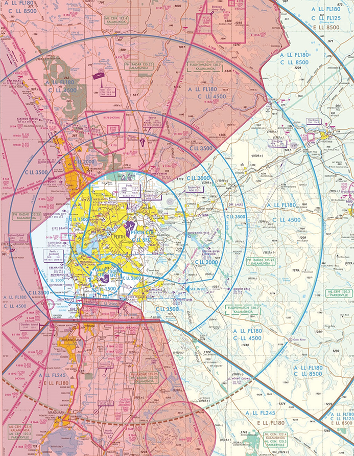
Flight paths for Perth Airport are designed around military airspace to the north, west and south, and Jandakot Airport airspace to the south. Military restricted areas are shown in pink in the image at right. Click to enlarge and use your back button to return to this page.
Military airspace (see image at right) can be active to ground level or it can begin at a certain altitude. Some military airspace is active only at certain times of the day and week. Where possible, flight paths are designed to remain under military airspace or to fly over the top of it. The close proximity of RAAF Base Pearce to the north means that air traffic controllers at Perth Airport have to coordinate their actions with RAAF controllers, including for changes of runway direction.
You can access historical information about flight path use through WebTrak. To access this information click the “Historical” link below the text in the Quick Start Guide at the top left-hand side of the screen. Then use the tick boxes at the bottom-right of the screen to select monthly, quarterly or yearly information. Use the sliders to refine your selection to specific timeframes.
To learn more about the runway at Perth Airport, take a look at our Perth Airport Runway page.
The illustration below shows how jet and non-jet (turbo-prop) aircraft typically operate at Perth Airport on the published instrument arrival and departure flight paths.
The animation is indicative only and provided for information purposes, on occasions flights may leave these general areas from time-to-time.
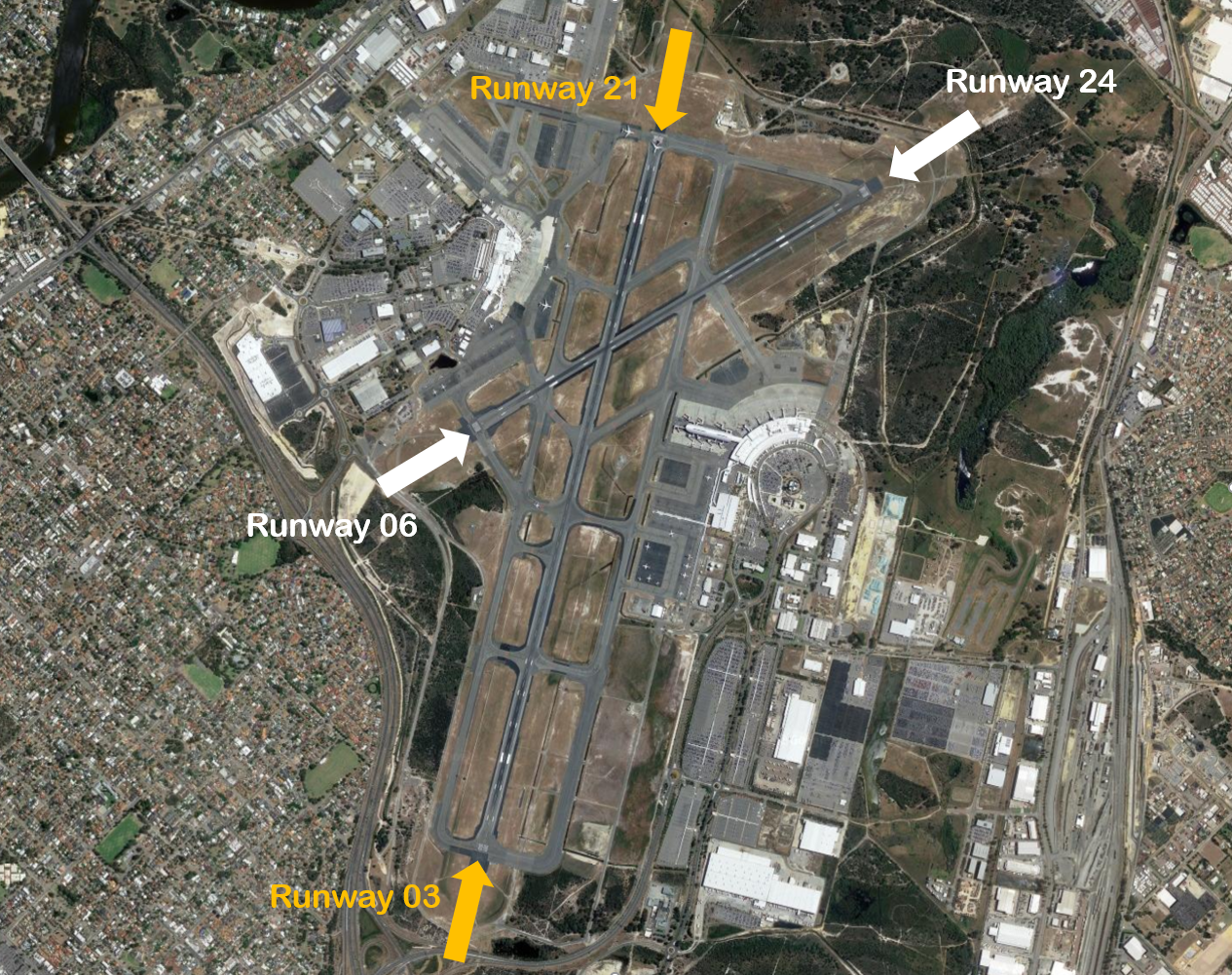
Perth Airport has two runways; the main runway 03/21 (3.4 km long) is orientated approximately north-south and the smaller cross runway 06/24 (2.2km) is orientated south-west to north-east.
Each runway is referred to differently according to in which direction it is being used. For example the main runway is known as Runway 03 when used in a northerly direction and Runway 21 when used in a southerly direction. Runway numbering reflects the runways’ orientation and correlates with degrees on a compass. Runway 21 is 210 degrees.
An Instrument Landing System operates for aircraft landing on Runways 03,21 and 24, and non-precision approaches are available to all runways.

The following video explains how runways are named and used.
Runway selection is based on wind direction, weather conditions, traffic volume and other factors. Aircraft primarily take-off and land into the wind for safety and performance reasons. Therefore, as the wind direction changes the runway in operation may also change depending on the strength of the wind.
This means that Perth’s seasonal wind patterns affect usage of the different runway directions. Specifically, Runway 21 tends to be used more frequently in the warmer months due to southerly winds whereas Runway 03 tends to be used more frequently in the cooler months when the predominant wind direction tends to be northerly.
Runways may be used in combination. For example, Runways 03 and 06 may be used at the same time for departures, or Runways 21 and 24 may be used at the same time for arrivals.
One of the factors taken into account in runway selection is operational requirements. For example, two operational factors make Runway 21 a more suitable choice for departures during peak periods. Firstly, the location of the terminals and hangars in relation to the runways means that departing aircraft can be moved to Runway 21 more efficiently than to other runways. Secondly, because there is so much military restricted airspace to the north of Perth Airport, there is more airspace available to the south in which to manage the mix of slow and fast aircraft in the air after departure. Both these factors become critically important when the volume of traffic is high. For these reasons, Runway 21 will usually be selected in peak periods if the wind allows it. Therefore it can be expected that Runway 21 will be used whenever possible for the morning departure burst which is the busiest period at Perth Airport. This begins around 5 am.
Noise abatement procedures are designed to help reduce the impact of aircraft noise on communities. While they are applied whenever it is possible to do so, their use is not mandatory and is subject to weather conditions and traffic requirements.
The Perth Airport Noise Abatement Procedures (NAP) state that all runways are equally preferred for arrivals and departures with the exception of Runway 06 for landing and Runway 24 for departures. This is due to the very close proximity of residential areas to this end of the crossing runway. This runway end is used on occasion however, for example when there is too much crosswind to use the main runway, and when the main runway is unavailable for reasons such as runway works.
Although the NAP state the other runways are equally preferred, this does not mean that they are equally used – rather that there is no preference in the use of the runways from a noise abatement perspective and the weather and operational requirements will determine the preferred runway.
The procedures also provide that:

Federally-leased airports (excluding Mt. Isa and Tennant Creek) have established Community Aviation Consultation Groups (CACGs), which provide an effective avenue for local community engagement on airport planning and operations, including aircraft noise. The Department for Infrastructure, Transport, Regional Development and Communications provides guidelines for CACGs.
Non federally-leased airports may also choose to establish CACGs or community forums.
CACG membership depends on the characteristics of the airport and any local issues of community concern however, generally includes:
Airservices does not formally belong to CACGs, but is invited to attend to provide relevant information and assist in discussions. We engage with CACGs on flight path and airspace changes, as well as technical reviews, such as noise monitoring and noise abatement procedures.
Find out more information on the Perth Airport Community Forum or Jandakot Airport Community Aviation Consultation Group.
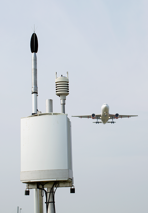
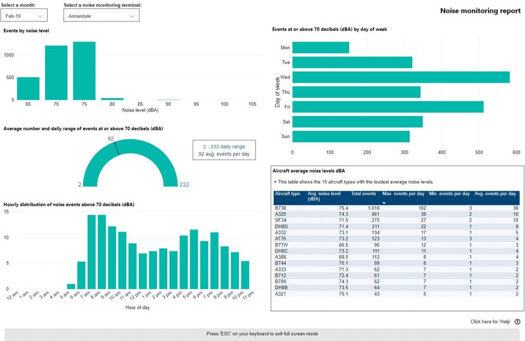
We collect noise and operational data from six noise monitors (Environmental Monitoring Unit, EMU) around Perth Airport. Noise monitors are listed below according to their location.
Access monthly data on our Perth noise monitoring reports page.

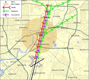
Captures arrivals to Perth Runway 03 and departures from Perth Runway 21.
EMU 1 and EMU 2 are overflown by similar aircraft. However, EMU 2 is located closer to, and aligned with, Runway 03/21, which results in it recording higher noise levels.

Captures arrivals to Perth Runway 03 and departures from Perth Runway 21.
Along with EMU 5 (Guildford), EMU 2 records the highest noise levels of all the noise monitors in Perth – these two noise monitors are closest to the end of the runways.

Captures arrivals to Perth Runway 24 and departures from Perth Runway 06.
The seasonal variation in the use of Runway 06/24 is reflected in the values recorded at this monitor.
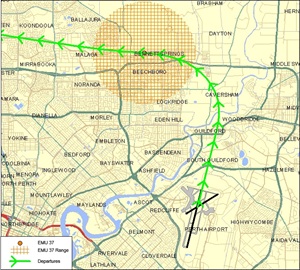
Captures arrivals to Perth Runway 21 and departures from Perth Runway 03.
Together with EMU 2, EMU 5 records the highest levels of all the noise monitors in Perth. These two monitors are closest to the end of runways and are overflown by both arrivals and departures.
Captures departures from Perth Runway 03.
Noise levels at EMU 37 are lower than at other noise monitors due to it being further from the end of a runway. This noise monitor is set only to capture those departures from Runway 03 that turn to the west.
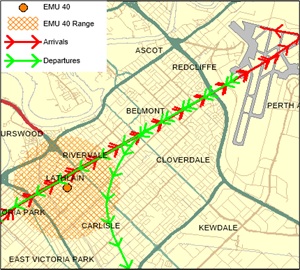
Captures arrivals to Perth Runway 06 and departures from Perth Runway 24.
The noise levels at EMU 40 are generally low, due to it being aligned with the cross-runway (06-24) at Perth Airport which is used much less than the main runway.
Learn more about monitoring aircraft noise on the Airservices website.
Circuit training is the first stage of practical pilot training focused on take-offs and landings. It involves the pilot making approaches to the runway or helipad, touching down and then applying power to take off again. This is undertaken in accordance with Civil Aviation Safety Authority (CASA) Regulations which are consistent with international practices.
Sixty per cent of movements at Jandakot Airport are undertaking circuit training, including both fixed wing aircraft and helicopters.
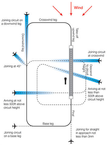
A training circuit consists of five legs – the take-off, crosswind, downwind, base and final approach to the runway.
Aircraft take off into the wind, climb to 500 feet and then turn onto the crosswind leg. They continue to ascend to 1000 feet and turn onto the downwind leg. Having turned onto the base leg the descent commences. After turning onto the final leg and lining up with the runway the aircraft will touch down and take off again.
The preferred runways under the noise abatement procedures for circuit training are Runways 06 Right and 24 Left. This means most of the aircraft undertaking circuit training operate south-east of the airport.
“Left-hand” circuits will be conducted when Runway 24 Left is in use and “right-hand” circuits when Runway 03 Right is in use. For left-hand circuits, the pilot turns left after take-off and flies anticlockwise. For right-hand circuit, the pilot turns right and flies in a clockwise direction.
A simplified representation of a left-hand circuit is shown at right. The take off and final stage of the circuit is flown into the wind, as this is the safest way for an aircraft to operate. The aircraft symbols and dotted lines indicate recommended ways for an aircraft to join the circuit pattern. Click the image to enlarge it, and use your browser “Back” button to return to this page.
Jandakot Airport’s voluntary Fly Neighbourly Agreement asks signatories to keep circuits as narrow as possible. However, because the student pilots performing circuits are so new to flying, this is not always achievable.
More information about circuit training is found here.
The animated aircraft below and the static tracks shown in blue are created from actual tracks flown by aircraft in the circuit. This illustrates the degree of variation that will occur in the way student pilots fly circuits. The altitudes above mean sea level of the aircraft are also shown.
You can enlarge to full-screen by clicking the square-shaped button in the bottom right-hand corner of the player.
To replay the animation press the “Replay” button in the bottom left-hand corner of the player.
Air traffic control will determine which runways are used at any given time depending on the direction of the wind – this is because aircraft must generally take off and land into the wind for safety reasons.
Depending on which runway direction is in use, different suburbs will be affected by different legs of the circuit. The Noise Complaints and Information Service tends to receive more complaints from suburbs under the crosswind and base legs of the circuit. This is the case at all airports where circuit training occurs.
The flight training circuits extend up to five kilometres from the airport. When Runway 06 Right or 24 Left are in use affected suburbs include Canning Vale, Jandakot, Banjup, Atwell, Success and Cockburn Central. When Runways 12 or 30 are in use affected suburbs also include Piara Waters, South Lake, North Lake and Leeming.
Training during both day and night is important for developing pilot competencies, as is experience with using different types of navigational aids.
Circuit training times are set out in the noise abatement procedures for Jandakot Airport and are:
Weekdays: 7:00am – 10:30pm
Weekends: 8:00am – 6:00pm
Please note that these times above apply only to circuit training, and not to arriving and departing aircraft which may operate 24 hours a day.
While there are set times for circuit training it is important to note that when aircraft are arriving outside control tower hours they are required to fly a circuit before landing for safety reasons. Therefore it may seem like aircraft are flying circuits outside hours when this is not the case.
The majority of aircraft using Jandakot Airport fly under Visual Flight Rules (VFR). There are designated routes for VFR aircraft to ensure that VFR traffic remains separate from aircraft flying under Instrument Flight Rules (IFR). It is not mandatory that VFR aircraft fly these routes, but many do, especially as they approach or depart airports.
These routes are outside controlled airspace (“OCTA”), that is, aircraft are not being directed by air traffic control. Whenever they fly outside controlled airspace, pilots are following the rules of the air. More information about airspace is found here.
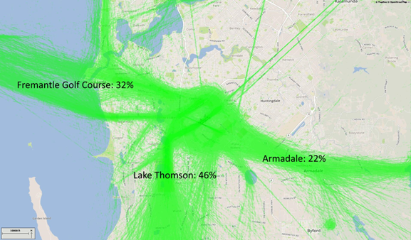
VFR routes include defined entry and exit points to and from controlled airspace. These are landmarks that are easily seen by the pilot from the air. These landmarks are highlighted in the images below, which also show the average percentage of arrivals or departures that use the route.
There is no minimum altitude for aircraft in the process of landing. Aircraft will generally descend on a glide slope of three degrees.
The altitude of aircraft after departure will depend on factors such as the type of aircraft and its weight, how heavily laden it is with fuel and passengers, and the atmospheric conditions at the time. All these factors affect an aircraft’s climb rate. There is no regulated minimum altitude for an aircraft in the process of taking off.
The main inbound tracks are via Canning Bridge, Forrestdale Lake and Adventure World.
The inbound route from the south begins at the boatyard at Henderson where aircraft need to be at 1500 feet. Aircraft then track to Adventure World.
For aircraft arriving from the north-east and east, from Canning Dam aircraft track to a point near Forrestdale Lake while descending to 1500 feet. This keeps them under the Perth Airport Control Area.
From the north-west, aircraft will fly down the coast from around Two Rocks by which time they must be below 4500 feet. Aircraft must remain over water to separate them from outbound aircraft which will track over land. They must be below 4000 feet by Cervantes and 2000 feet by Lancelin. Approaching Mullaloo Pont aircraft must descend to below 1500 feet to remain clear of controlled airspace. They will turn inland at the South Fremantle Power Station and track to Adventure World, maintaining 1500 feet.
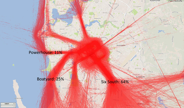
The main departure routes from Jandakot are northwest via the Fremantle Golf Course, southeast via Armadale and south towards the Training Area, via Yangebup and Thompson Lakes.
Outbound aircraft for the north-west track along the coast remaining over land to avoid the inbound route over the water. They must maintain the departure altitude of 1000 feet until over Murdoch University Open Space so as not to conflict with arrivals via Adventure World which are at 1500 feet. At that point they can climb to 1500 feet, but not above or they will infringe controlled airspace. After tracking to Fremantle Golf Course they either proceed to Rottnest Island at 1500 feet, or turn north.
Aircraft heading south will track via Yangebup Lake and Lake Thomson. If departing Runway 06 Left, they will make a left-hand turn and follow the railway line to the south-west in order to remain clear of traffic that may be on the base leg of the circuit. Once past the junction of the railway line and Kwinana Freeway they will track to Lake Yangebup. Aircraft then track via the eastern shoreline of the lakes and maintain the altitude of 1000 feet. Once past Casuarina Prison aircraft can climb up to 6000 feet.
The route for aircraft outbound to the east is via Armadale. One thousand feet must be maintained until abeam Forrestdale Lake to ensure separation from arriving aircraft at 1500 feet. From Armadale aircraft must remain below 3500 feet as they track towards Canning Dam.
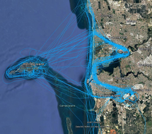
Scenic Route
There is an established scenic route through Perth Airport’s controlled airspace via Fremantle Golf Course. Some flights will combine the scenic route with a visit to Rottnest Island, as can be seen in the image, right.
The route will vary depending on movements in and out of Perth Airport. It is either a right-hand turn towards the city at Cottesloe, or air traffic control may require the aircraft to fly further north past Cottesloe and City Beach before turning right and flying the route in reverse.
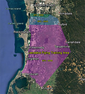
Designated training areas have been established by the Civil Aviation Safety Authority for flight training. For Jandakot Airport these exist to the south of the airport. Once pilots progress past the circuit training stage of their courses they will begin flying to and around the training area.
Aircraft do not require a clearance from air traffic control to operate within the training areas because they are outside controlled airspace.
Three connected pieces of airspace comprise the training area. The first starts about 7km south of the airport and exists from the surface (“SFC”) up to 2500 feet. South of this the upper level rises to 3500 feet and then to 6000 feet. The training area extends south to Mandurah and Pinjarra then up to Serpentine Dam and up to the Byford area.
Low level aerobatics is also allowed in a number of areas, around Murray Field, Serpentine, and north of Mundijong.
Aircraft tracking to the training areas will track via Yangebup Lake and Lake Thomson. Tracking from the training areas to the airport the aircraft will either track coastal over Lake Coogee or via Forrestdale Lake.
There is also a helicopter training area on the airport directly to the east of Runway 06R / 24L. At times there may also be helicopter training to the south of Runway 12/30.
Flight paths are not precise, defined paths like runways, but more like corridors that are often several kilometres wide.
Arriving aircraft will line up with the runway centreline and fly straight in on the runway heading. Aircraft will approach Canberra from all directions before they join the final approach path. Jet aircraft will join the final approach between 15 and 25 kilometres from Canberra Airport and fly towards the runway in a straight line. Jet aircraft will generally be at altitudes from 3000 to 4000 feet when they join the final approach. There is no minimum altitude for aircraft in the process of landing. Aircraft will generally descend on a glide slope of three degrees.
Departing jets will generally maintain a straight line from the runway for around 15 kilometres before turning to their heading.
The altitude of aircraft after departure will depend on factors such as the type of aircraft and its weight, how heavily laden it is with fuel and passengers, and the atmospheric conditions at the time. All these factors affect an aircraft’s climb rate. There is no regulated minimum altitude for an aircraft in the process of taking off.
A growing number of modern aircraft are now fitted with navigation systems that use satellite-assisted guidance which allow aircraft to fly with a higher degree of accuracy and more closely follow the same route as other aircraft. Airservices refers to these routes as ‘Smart Tracking’. Smart Tracking technology makes air travel safer, cleaner and more dependable. It also has the potential to improve noise outcomes for communities living close to airports.
You can access historical information about flight path use through WebTrak. To access this information click the “Historical” link below the text in the Quick Start Guide at the top left-hand side of the screen. Then use the tick boxes at the bottom-right of the screen to select monthly, quarterly or yearly information. Use the sliders to refine your selection to specific timeframes.
Canberra Airport has a number of flight paths from its runway.
To learn more about the runway at Canberra Airport, take a look at our Canberra Airport Runway page.
The illustration below shows how jet and non-jet (turbo-prop) aircraft typically operate at Canberra Airport on the published instrument arrival and departure flight paths.
The animation is indicative only and provided for information purposes, on occasions flights may leave these general areas from time-to-time.

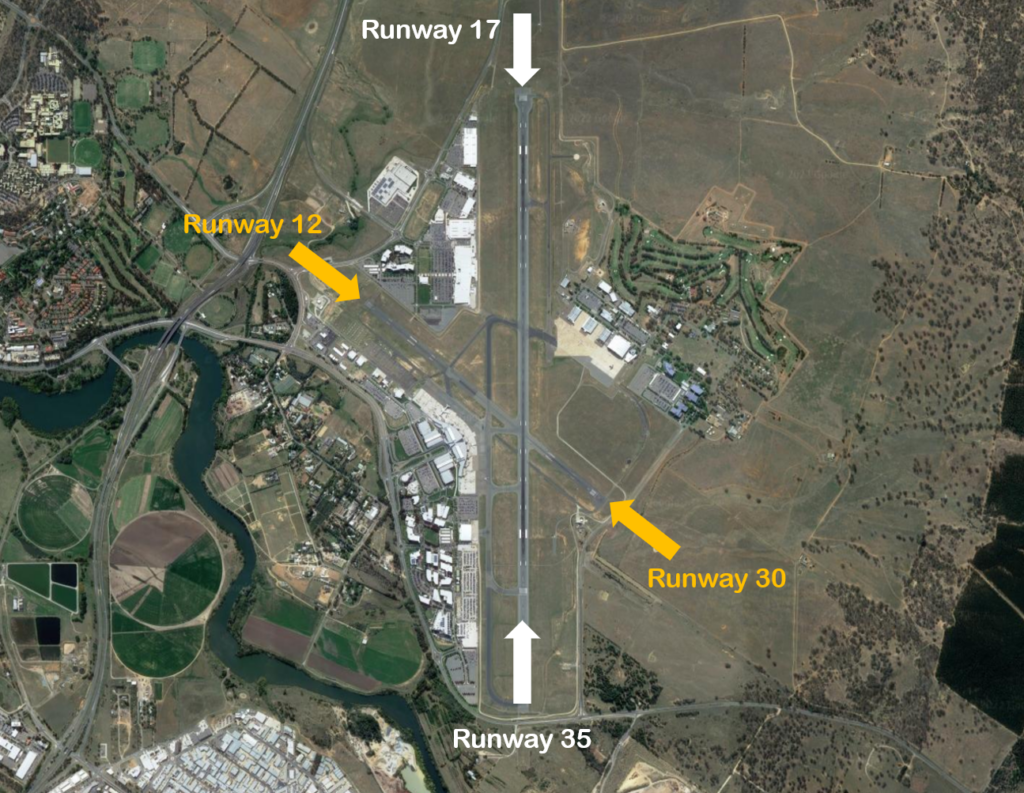
Canberra Airport has two runways; the main runway 17/35 (3.28 km long) is orientated north-south and is used for the majority of aircraft traffic. The shorter runway 12/30 (1.67km) is orientated east-west and is used mainly for propeller aircraft.
Each runway is referred to differently according to in which direction it is being used. For example the main runway is known as Runway 35 when used in a northerly direction and Runway 17 when used in a southerly direction. Runway numbering reflects the runways’ orientation and correlates with degrees on a compass. Runway 35 is 350 degrees.
An Instrument Landing System operates for aircraft landing on Runway 35, and Smart Tracking procedures are available for aircraft landing on Runways 35 and 17.
The following video explains how runways are named and used.
Runway selection is based on wind direction, weather conditions, traffic volume and other factors. Aircraft primarily take-off and land into the wind for safety and performance reasons. Therefore, as the wind direction changes the runway in operation may also change depending on the strength of the wind.
This means that Canberra’s seasonal wind patterns affect usage of the different runway directions. The prevailing winds favour Runway 35 which is used more than 70 per cent of the time. Runway 17 tends to be used more frequently in the warmer months than at other times, but this does vary.
A noise abatement area applies to most residential areas of Canberra and Queanbeyan. Aircraft will normally be routed to avoid the noise abatement area, which covers most of Gungahlin, North Canberra, Belconnen, South Canberra, Woden, Tuggeranong and Queanbeyan. Where it is not practical for aircraft to remain clear of those areas, during overflight jet aircraft must not fly below 7 000 feet above ground level and large propeller aircraft not below 5 000 feet. Smaller propeller aircraft are permitted. A number of exceptions apply to the noise abatement areas such as aircraft emergencies, medical priority flights, avoidance of hazardous weather, missed approaches and operational requirements.
Powered by: 