Jandakot Airport Runways

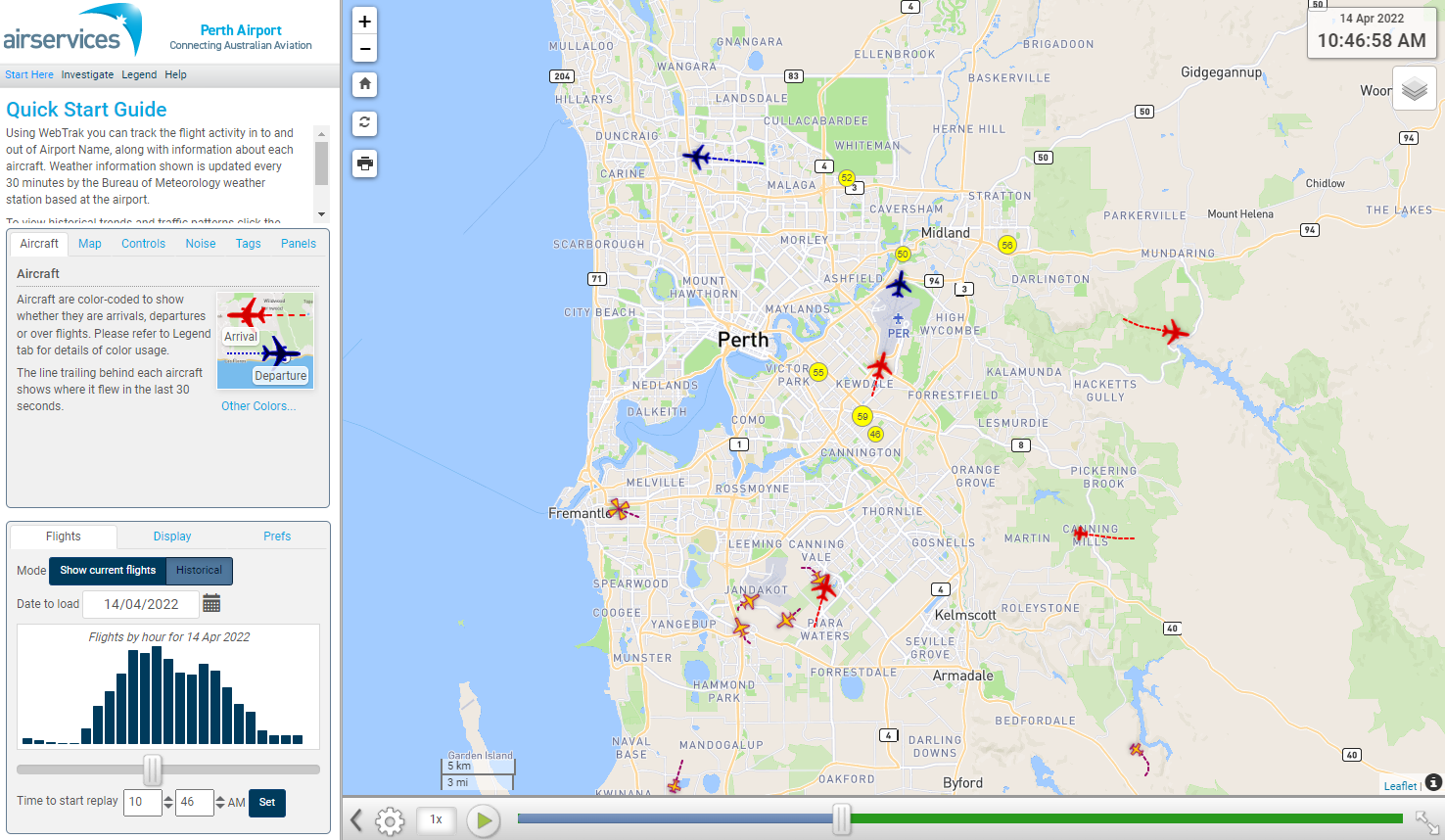
Jandakot Airport has three runways. A set of parallel runways, known as Runways 06 Left/24 Right and Runways 06 Right/24 Left are aligned approximately north-east to south-west. These runways are used for approximately 85 per cent of all movements. The alternate runway, Runway 12/30, is aligned approximately north-west to south-east.

Each runway is referred to differently according to in which direction it is being used. For example, the parallel runways are referred to as Runway 06 Left and Right when used in a north-easterly direction and Runway 24 Left and Right when used in a south-westerly direction.

Runway numbering reflects the runways’ orientation and correlates with degrees on a compass. Runway 06 is 60 degrees magnetic.

The following video explains how runways are named and used.

Runway selection and seasonal winds

Runway selection is based on wind direction, weather conditions, traffic volume and other factors. See the Runway Selection page for more details. Aircraft primarily take-off and land into the wind for safety and performance reasons. Therefore, as the wind direction changes the runway in operation may also change depending on the strength of the wind.

This means that Perth’s seasonal wind patterns affect usage of the different runway directions. For example, Runways 06 Left and Right tend to be used more often in the cooler months when there are frequent winds with a northerly component. Runways 24 Left and Right tend to be used more frequently in the warmer months when the predominant wind direction tends to be southerly.

Outside of Tower operating hours the pilot must determine the runway to be used based on the wind direction.

Noise abatement procedures

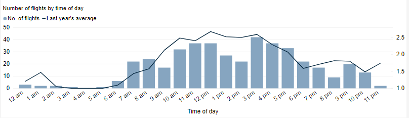
Noise abatement procedures are designed to help reduce the impact of aircraft noise on communities. While they are applied whenever it is possible to do so, their use is not mandatory and is subject to weather conditions and traffic requirements.

The preferred runways for circuit training are Runways 06 Right and 24 Left. This means that most of the aircraft undertaking circuit training operate to the south-east of the airport. There are also set hours for circuit training.

Runways 06 Left and 24 Right are the preferred runways for other arrivals and departures.

There are voluntary ‘Fly Neighbourly Agreements’ between airport management and aircraft operators. These are intended to minimise the impact of aircraft noise on the surrounding community. More information is available on the Jandakot Airport website.

The principles of these Fly Neighbourly Agreements are, whilst maintaining safety of operations, to:

  • climb as soon as possible
  • maintain height
  • reduce engine revs as soon as possible
  • follow designated flight paths
  • avoid residential areas where possible
  • not fly wide circuits unless required by air traffic control

How many aircraft fly near me?

This tool shows the number of flights each day over your area in the selected month compared to the average for last year.  The bottom axis shows the day of the month. Use the drop-down menu to change the selected month to see how movements have varied. Hover over each day to see flight numbers.

*Please note due to technical issues between 19 June and 22 June 2024, flight data may not be accurately displayed. Our supplier is working to resolve the issue. We apologise for any inconvenience this may cause.

What was that flight?

WebTrak is a tool that enables the community to see where aircraft fly and explore historical trends and patterns. WebTrak is provided by Envirosuite.

WebTrak uses information from air traffic control radars to display aircraft movements. The flight search and display function allows you to view aircraft flight activity over metropolitan areas. You can also:

  • locate your street address and have your home appear on the map
  • see noise levels of individual aircraft
  • view information about aircraft type, height, origin and destination
  • display an aircraft’s flight path and point of closest approach to your home
  • zoom in and out down to street level.

Note that there is a slight delay on the display of flights.

You can view WebTrak for your region here.

Or, find out more information about WebTrak and how to use it.

How frequent are flights in my area?

There are a number of factors that influence the frequency of flights.

Firstly, the number and frequency of flights will vary on a daily, weekly and yearly basis due to differences in airline schedules. The airlines schedule flights in response to consumer demand. This is particularly the case around Christmas, Easter, school holidays and Lunar New Year.

Secondly, the runway in use at any given time will also vary, largely due to the wind conditions. Each runway has its own set of flight paths, and each flight path will affect different areas. As the runway in use changes, the flight paths change, and so too do the areas affected by aircraft movements.

This chart shows the total number of flights each hour over the month, compared to the average for last year. Change the selected month to see how it has varied.

*Please note due to technical issues between 19 June and 22 June 2024, flight data may not be accurately displayed. Our supplier is working to resolve the issue. We apologise for any inconvenience this may cause.

How high are aircraft near me?

The altitudes of aircraft over your area can vary according to:

  • the airport the flight is coming from or going to
  • whether the aircraft is arriving, departing or in level flight
  • the specific requirements of the flight path
  • the need for air traffic control to maintain vertical separation between aircraft.

Find out more on our What are the rules about altitudes? page.

*Please note due to technical issues between 19 June and 22 June 2024, flight data may not be accurately displayed. Our supplier is working to resolve the issue. We apologise for any inconvenience this may cause.