Cambridge Airport Flight Paths

Cambridge Airport has a range of General Aviation (light aircraft) operations.

To learn more about Cambridge Airport operations, take a look at our Cambridge Airport circuits page.

The illustration below shows how light aircraft typically operate at Cambridge Airport. These aircraft usually fly using visual flight rules, where the pilot uses visual references to the ground or water rather than flying on a published instrument flight path. This means we see a broad area where light aircraft may fly.

The animation is indicative only and provided for information purposes, on occasions flights may leave these general areas from time-to-time.

Hobart Airport Runway

Hobart Airport has one 2.7 kilometre long runway (aligned north-west/south-east) that operates in both directions, depending on the wind at the time of take-off or landing.

The following video explains how runways are named and used.

The runway at Hobart Airport is called Runway 12/30.

Runway numbering reflects the runways’ orientation and correlates with degrees on a compass. Runway 30 is 300 degrees while Runway 12 is at 120 degrees.

Operations in a south-easterly direction use Runway 12, and operations in a north-westerly direction use Runway 30.

The image below shows the runway at Hobart, with:

  • The yellow arrow pointing to Runway 12
  • The white arrow pointing to Runway 30.

To learn more about the flight paths at Hobart Airport, take a look at our Hobart Airport Flight Paths page.

Hobart Airport Flight Paths

Hobart Airport has a number of flight paths from its runway.

To learn more about the runway at Hobart Airport, take a look at our Hobart Airport Runway page.

The illustration below shows how jet and non-jet (turbo-prop) aircraft typically operate at Hobart Airport on the published instrument arrival and departure flight paths.

The animation is indicative only and provided for information purposes, on occasions flights may leave these general areas from time-to-time.

How many aircraft fly near me?

This tool shows the number of flights each day over your area in the selected month compared to the average for last year.  The bottom axis shows the day of the month. Use the drop-down menu to change the selected month to see how movements have varied. Hover over each day to see flight numbers.

Sydney Airport departures

North flow
Jet and turbo-prop aircraft that are heading for destinations to the west, north and north-west will fly over or near your area after departure from Sydney Airport. This corridor is labelled D5 in the image, right. These flights are bound for destinations such as Dubbo, Perth, Adelaide, Darwin, Broome, Singapore, Kuala Lumpur, Dubai, Abu Dhabi, Hong Kong and Shanghai.

As shown in the image below of actual tracks of departing aircraft, there are two concentrated flight paths. One tracks towards Richmond, passing over suburbs such as Ermington, Baulkham Hills and South Windsor. The other tracks towards Katoomba over Parramatta, St Clair and South Penrith.

Aircraft will also fly on either side of these two flight paths. This traffic is being individually directed by air traffic control in order to manage the volume of aircraft in the airspace. For example, a slower aircraft may be moved off the main flight path in order to take it out of the way of a faster jet behind it.

Altitudes over your area will vary according to factors such as the weight of the aircraft and how heavily laden it is. For example, long-haul aircraft departing for Dubai will be much heavier than smaller aircraft heading to Perth or Adelaide due to fuel load and aircraft size and therefore they will climb more slowly. The maximum take-off weight (MTOW) for an Airbus A380 is 560,000kg and for a Boeing B747 it is 396,890kg. The MTOW of an A320 is 73,500kg and for an A330 it is 230,000kg.

While differences in weight will affect an aircraft’s climb rate, even the atmospheric conditions at the time can play a part in how quickly an aircraft can climb. When the weather is warm, the air is less dense and therefore there is less lift and the aircraft climbs more slowly.

Generally, the average altitude of an A380 over Parramatta is around 5,500 feet and over South Penrith around 9,000 feet. In contrast the average for the smaller A320 or B737 over Parramatta is around 6500 feet and over South Penrith around 14,000 feet.

Over Baulkham Hills an A380’s average altitude is around 7000 feet and over Richmond around 11,500 feet. An A320/B737 would be at an average of around 8,500 feet over Baulkham Hills and 15,000 feet over Richmond.

This image shows the tracks of departing aircraft:

Departures

When is each flight path used?

Air traffic control manage the traffic to each runway at an airport using a range of operations which can include clearing aircraft to use published flight paths, issuing visual approaches or vectoring for separation and sequencing. As the runway in use changes, the types of operations in use will also change, and so different suburbs and areas are affected by aircraft movements.

Flight paths do not operate in isolation. They are part of an interconnected network. Flight paths need to accommodate aircraft operating constraints, provide terrain clearance and fit into the overall airspace design.

Arrivals

Arriving aircraft need to align with the runway prior to touching down. Depending on the arrival or approach procedure being flown, aircraft may align with the runway from a few kilometres to beyond twenty kilometres from touchdown.

When the sky is clear and there is no low cloud along the approach path, aircraft may join the runway alignment closer to the airport. If there is low cloud or other weather impeding visual conditions, aircraft will align with the runway further from touchdown and will fly the published flight path.

A further consideration is the density of traffic. If there are frequent arrivals to both runways, aircraft will align with the runway further from touchdown in accordance with established parallel runway flight procedures.

Departures

Departing aircraft can turn once they are airborne and stabilised. Both turbo-prop and jet aircraft operate at Brisbane Airport. These aircraft types have different operational capabilities and are separated accordingly.

Departures from the new runway plan to fly to ports to the north or the west, and are required to turn. The departure procedure for turbo-prop aircraft sees these aircraft types turn at an altitude of 600 feet but not before the runway end. This is necessary to move the aircraft onto the planned route and also to move the aircraft out of the path of the faster moving jet aircraft.

Jet aircraft maintain the runway heading on departure. They do so in order to gain altitude so that when they do turn, they are higher than the propeller aircraft departures and can safely pass above them.

If turbo-prop and jet aircraft departed on the same flight path there would be more time needed between movements due to differences in the operational capabilities. This would impact the efficient operation of the airport by reducing the throughput of aircraft.

Alternative Flight Paths

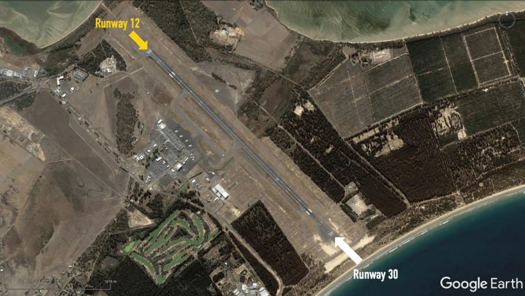
The Brisbane new parallel runway operations design has certain modes of operation and generally aircraft departing to or arriving from the west or the north will land and depart on the new runway, while aircraft departing to or arriving from the south or east will land and depart on the legacy runway.

However to maximise the safety and efficiency of operations, the airspace design also includes flight paths that track from all directions to both runways. 

This provides air traffic control with the option to use these flight paths to effectively manage air traffic in high workload periods, including when there is bad weather, runway maintenance or an emergency, or in periods of air traffic delays, including holding.


Learn more about how the runways are selected on our Brisbane Airport Runways page.

Sydney Airport Community Forum

Federally-leased airports (excluding Mt. Isa and Tennant Creek) have established Community Aviation Consultation Groups (CACGs), which provide an effective avenue for local community engagement on airport planning and operations, including aircraft noise. The Department for Infrastructure, Transport, Regional Development and Communications provides guidelines for CACGs.

Non federally-leased airports may also choose to establish CACGs or community forums.

CACG membership depends on the characteristics of the airport and any local issues of community concern however, generally includes:

  • airport management
  • aircraft operators
  • community organisations or representatives
  • representatives from state, territory or local government bodies
  • local tourism and business groups.

Airservices does not formally belong to CACGs, but is invited to attend to provide relevant information and assist in discussions. We engage with CACGs on flight path and airspace changes, as well as technical reviews, such as noise monitoring and noise abatement procedures.

Find our more information on the Sydney Airport Community Forum (SACF) webpage.

Meeting Summary Minutes

2024

2023

2022

2021

Investigation: Heavy international departures at night

In 2016, we investigated whether heavy jets could turn left instead of right after departure from Runway 19L (the legacy runway) at night, and whether there were any other options for noise sharing at night.

A number of alternative routes are used for departures from Runway 19L. Data analysis indicated that the departure paths at night are concentrated. Allowing a left turn, or any other noise sharing method, would expose new parts of the community to noise levels above 60 dB(A) at night. This level would be considered ‘potentially significant’ under the Environment Protection and Biodiversity Conservation Act.

Our investigation found that the best noise outcome was to maximise the use of reciprocal runway operations at night, and to work with international airlines to ensure maximum use of Runway 01R for departures over the bay.

Brisbane airport community aviation consultation group

Federally-leased airports (excluding Mt. Isa and Tennant Creek) have established Community Aviation Consultation Groups (CACGs), which provide an effective avenue for local community engagement on airport planning and operations, including aircraft noise. The Department for Infrastructure, Transport, Regional Development and Communications provides guidelines for CACGs.

Non federally-leased airports may also choose to establish CACGs or community forums.

CACG membership depends on the characteristics of the airport and any local issues of community concern however, generally includes:

  • airport management
  • aircraft operators
  • community organisations or representatives
  • representatives from state, territory or local government bodies
  • local tourism and business groups.

Airservices does not formally belong to CACGs, but is invited to attend to provide relevant information and assist in discussions. We engage with CACGs on flight path and airspace changes, as well as technical reviews, such as noise monitoring and noise abatement procedures.

Find out more information on the Brisbane Airport Community Aviation Consultation Group webpage.

Investigation: Southern departures trial

In 2013, we developed a trial departure procedure to minimise the noise impact on La Perouse and the Kurnell Peninsula.

The procedure was tested using flight simulators. While normal or low weight operations were able to fly the procedure, in certain weather conditions, heavy aircraft flew over the tip of the Kurnell Peninsula.

Overall, the trial procedure delivered no better outcome than the current design, so was not progressed.