Learn about flight paths and aircraft movements in your area
Welcome to the Aircraft in Your Neighborhood Portal
Our goal is that you will learn more about the flight paths and aircraft movements in your area and be able to access the information and resources that explain how air traffic is managed.
First, please select your location using one of the following options, so that we can customize the information for your location.
We’ll remember your location so you don’t have to enter it every time you visit the site and we’ll keep this information confidential.
Please note, that this site works best on Chrome, Firefox and Edge.
* Mandatory - Select region first to view the map.
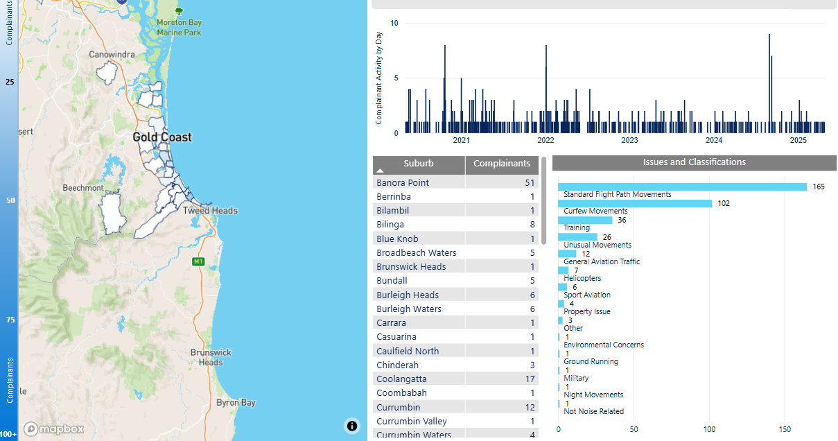
We manage complaints and enquiries about aircraft noise and operations through our Noise Complaints and Information Service (NCIS). The information below is collected for the purpose of complaint management, analysis of issues and identification of causal factors.
For this reason we refer to ‘complainants’ and ‘issues’. Complainants are people who contacted us. While some people submitted enquiries or comments rather than complaints, all are referred to as “complainants”. Issues are the primary concern they raised.
The complaints report
Use this interactive tool to explore the issues raised by residents from different suburbs. For help, click the button in the bottom right-hand corner.
At Airservices, we regard the safety of air navigation as the most important consideration and as far as practicable we work to protect the community and environment from the effects of aircraft operations, including aircraft noise.
We manage complaints and enquiries about aircraft operations and Airservices Australia’s community engagement activities through our Noise Complaints and Information Service (NCIS). We use complaints and enquiries to help us identify operations of concern and possible opportunities for improvement.
When you contact us, please provide your contact details and as much information about your complaint or enquiry as possible.
You may choose to remain anonymous on the webform, or when calling or writing to us. To receive a response, we require some details including your suburb or location to identify the operations you are enquiring about and an email address to send the response to. By providing your details, we may also send you updates on relevant flight path changes and other Airservices activities in your area.
We will not respond to any submissions that contain threatening, abusive, discriminatory, racist, offensive, obscene, vulgar, profane and inflammatory language. Threatening or unlawful comments may be reported to the relevant state and federal authorities.
If you feel negatively impacted by aircraft noise, you could consider reaching out to one of the following support services:
Lifeline 24 hr Counselling Service: 13 11 14
Beyond Blue: 1300 224 636
Airservices Australia has extended our Employee Assistance Program to any community member who is feeling negatively affected by aircraft noise. This is a confidential service, free of charge to community members, and is provided completely independently of Airservices Australia. All personal details will be kept confidential. More information is available here or you can call 1300 687 327. If requested, please use “organisation code” AIRSUPPORT and if asked for a “division” please use Community Support.
TIS is a free service that provides access to a telephone interpreter in many different languages.
Other Complaints
NCIS is the Australian aviation industry’s main interface on aircraft noise and related issues for the community. If you have a complaint that does not relate to aircraft noise, visit the Australian Government’s Aviation Complaints website to find the right place to direct your complaint.
Training during both day and night is important for developing pilot competencies, as is experience with using different types of navigational aids.
Circuit training times are set out in the Noise Abatement Procedures for Camden Airport. These are:
Monday to Friday, non-daylight saving periods: 7:00am – 10:00pm
Monday to Friday, daylight saving periods: 7:00am – 10:30pm
Weekends: 7:00am to 8:00pm
Due to flying training courses running on different schedules, some nights will have multiple aircraft operating and other nights none at all.
These times above apply only to circuit training, and not to arriving and departing aircraft which may operate 24 hours a day. When aircraft are arriving outside control tower hours they are required to fly a circuit before landing for safety reasons. Therefore it may seem like aircraft are flying circuits outside hours when this is not the case.
Altitudes
Aircraft aim to fly at 1,000 feet on the downwind leg. This is because aircraft are ascending on the take-off and crosswind legs and descending on the base and final legs.
While attaining 1,000 feet on the downwind leg is the aim, in reality the altitudes of aircraft that are conducting circuit training will always vary. Part of the reason for this is that the trainees are new to flying and factors such as their level of experience and even their degree of nervousness will affect the altitudes they can achieve. Unfortunately the nature of circuit training is to teach new pilots and therefore this variation cannot be avoided.
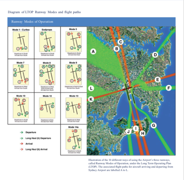
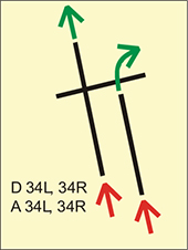
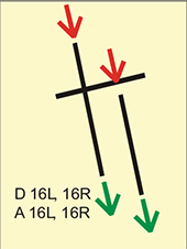
It is a common misconception that noise sharing means that flight paths are varied. This is not the case. Using the same standard flight paths is vital for safety, particularly at very busy airports like Sydney, because they reduce complexity for pilots and air traffic controllers. If a different flight path was used for every flight it would be very complex to ensure aircraft remained safely separated, and there would be a high possibility of confusion and error.
While flight paths themselves are not varied, there are different flight paths for each runway, each of which will affect a different part of the community. Because aircraft need to land and take off into the wind, the runway used generally will be the one that best suits the wind direction at the time. As the wind and other conditions change, the runway configuration or “mode” may also change, bringing a different set of standard flight paths into use. This has the effect of sharing the noise.
Peak period modes
Mode 9
Mode 10
Modes 9 and 10 utilise both parallel runways at the same time. Mode 9 is a flow towards the north and Mode 10 is a flow towards the south.
During peak periods one of these parallel runway modes will always be used whenever the wind permits because using two runways at once enables the most traffic to be moved through the airport. The peak periods are generally from 7:00 – 11:00am and 3:00 – 8:00pm but may extend beyond these hours.
Noise sharing modes
During non-peak times for the airport air traffic controllers must implement a “noise sharing mode” whenever it is possible to do so according to the wind conditions and other factors. Non-peak times for the Airport are generally 6:00 – 7:00am, 11:00am – 3:00pm, 8:00pm – curfew.
Noise sharing modes generally use the east-west runway and the parallel runways. The modes that utilise the east-west runway can only be used when traffic volumes are low. This is because the east-west runway crosses both the parallel runways; the need for aircraft to cross active runways slows down operations significantly and in busy periods this would result in delays and holding in the air.
For all the noise sharing modes there is an option for pilots of heavy jets to request use of the longer westernmost parallel runway. In the images below this option is represented by dotted lines.
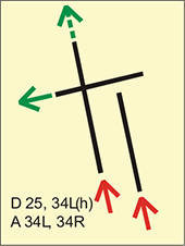
Mode 5
Mode 5
In Mode 5 the east-west runway is used for arrivals from the east and the parallel runways are used for departures towards the south.
Due to seasonal wind conditions, use of Mode 5 tends to rise as the weather cools.
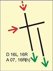
Mode 7
Mode 7
In Mode 7 the parallel runways are used for arrivals from the south and the east-west runway is used for departures towards the west.
Wind conditions in the cooler months tend to favour the use of Mode 7 and it is generally used more frequently at that time of year.
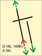
Mode 14a
In Mode 14a the east-west runway is used for arrivals from the west and the parallel runways are used for departures towards the south, over the bay.
Mode 14a tends to be used more frequently in the warmer months due to favourable wind conditions.
SODPROPS
Simultaneous Opposite Direction Parallel Runway Operations
In Simultaneous Opposite Direction Parallel Runway Operations, (SODPROPS), aircraft arrive and depart over the bay. Arrivals use the westernmost parallel runway and departures use the easternmost parallel runway. This mode is the preferred noise sharing mode, however it can only be used when the wind and weather conditions are exactly right with maximum visibility for pilots and air traffic controllers in the Tower.
East-west runway only modes
Mode 12
Mode 13
Modes 12 and 13 are used when the wind conditions preclude use of the parallel runways because the crosswind exceeds safety limits. If there is a very strong westerly wind, Mode 13 is used. If there is a very strong easterly wind, Mode 12 is used.
When one of these modes has to be used for extended periods it limits the amount of aircraft that can be moved through the airport. This results in delays which can have a cascading effect around the country.
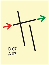
Curfew mode
Curfew mode
During the curfew, aircraft permitted to use the airport must arrive and depart from the westernmost runway. Emergency medical flights are exempt from this requirement and may use whichever runway will expedite their flight.
There is no legislation or regulation that restricts the number of flights that can fly over an area.
Sydney Airport has a legislated cap on movements that restricts the number of flights to a maximum of eighty per hour. This includes both arrivals and departures.
Airservices is charged with implementing this cap by counting movements per hour on a rolling 15-minute basis. If the cap is at risk of being exceeded air traffic controllers will take actions such as holding aircraft in the air or on the ground, to arrive or depart in the next hour.
The movement cap applies only to Sydney Airport. There is no limitation on the number of flights that can use other airports around Australia.
In Australia, aircraft noise standards apply before an aircraft is allowed to operate here, rather than in the course of its day-to-day flying activities.
Before an aircraft begins operating in Australia it is required to meet international noise standards that specify the amount of noise that may be emitted by that type or model of aircraft. If an aircraft does not pass the certification process, it may not fly in Australia. However once an aircraft passes this certification process, there is no legislation or regulation that enables any agency, including Airservices, to police its noise levels.
There is no regulated maximum noise level for aircraft flying over residential areas. Without any maximum level set out in legislation or regulation, there is no objective measure to determine whether any aircraft flying in Australia is “too noisy”, or whether the combined load of aircraft experienced by a community is “too much” noise.
Archerfield Airport is a large general aviation airport catering for charter flights, flight training, aircraft maintenance and emergency response units, both fixed wing and helicopters.
Archerfield Airport operates 24 hours a day, seven days per week. It is Brisbane’s secondary airport and Queensland’s major centre for general aviation activities.
Noise abatement measures are taken on the ground such as designated run-up bays and specific helicopter landing areas.
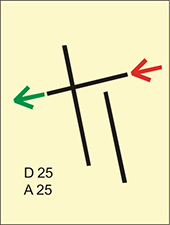
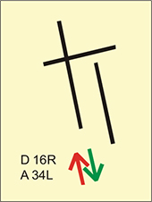
Flight paths
The majority of aircraft using Archerfield Airport fly under Visual Flight Rules (VFR). There are designated routes for VFR aircraft to ensure that VFR traffic remains separate from aircraft flying under Instrument Flight Rules (IFR). It is not mandatory that VFR aircraft fly these routes, but many do, especially as they approach or depart airports. These routes are outside controlled airspace.
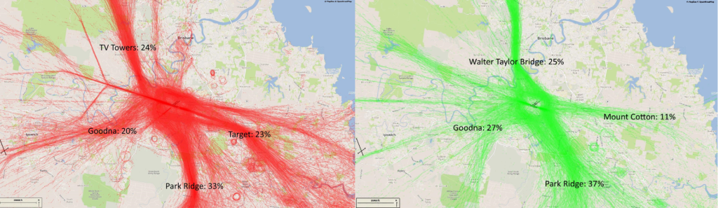
VFR routes include defined entry and exit points to and from controlled airspace. These are landmarks that are easily seen by the pilot from the air. These landmarks are highlighted in the images below, which also show the average percentage of arrivals or departures that use the route.
There is no minimum altitude for aircraft in the process of landing. Aircraft will generally descend on a glide slope of three degrees.
The altitude of aircraft after departure will depend on factors such as the type of aircraft and its weight, how heavily laden it is with fuel and passengers, and the atmospheric conditions at the time. All these factors affect an aircraft’s climb rate. There is no regulated minimum altitude for an aircraft in the process of taking off.
The below images are an example of standard flight paths into and out of the airport on a normal day.
Arrivals and Departures for Archerfield, showing the visual landmarks used by pilots.
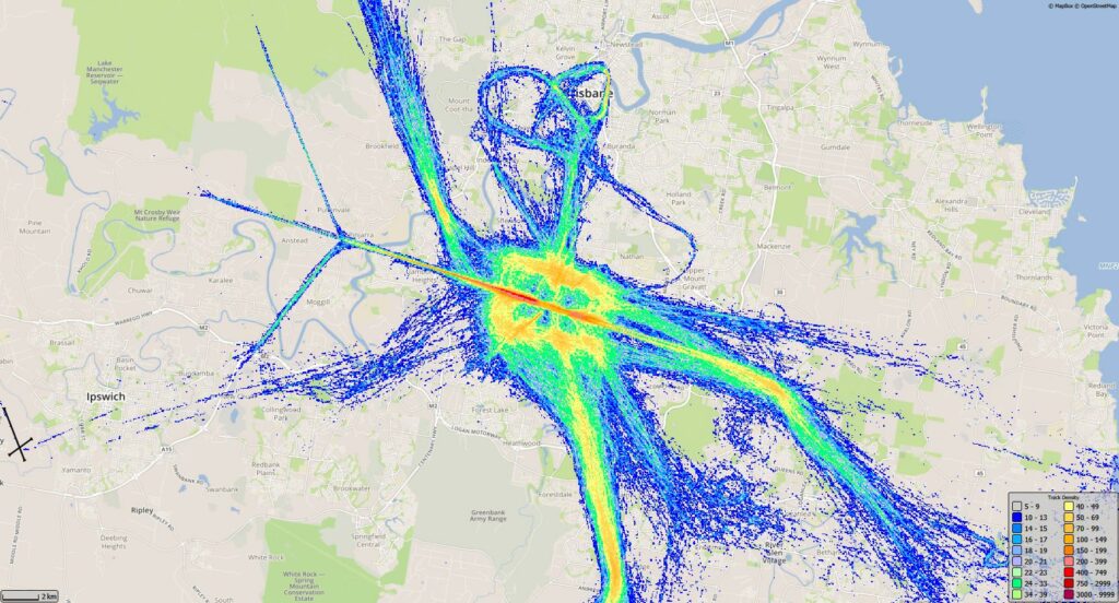
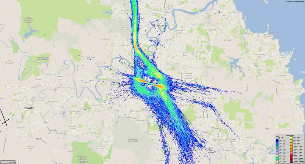
Shown below are track densities for Archerfield from January to March 2020. A track density is generated by overlaying a grid on the map, and coloring that grid based on a count of how many operations passed through each grid square. Cooler colours are used for low counts, and warmer colours for high traffic.
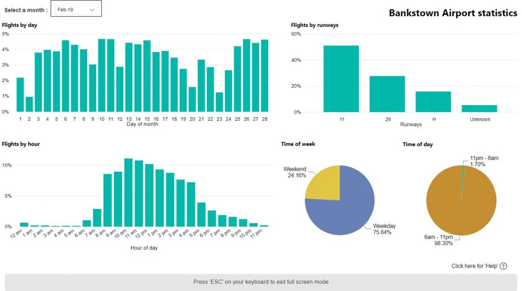
Use this interactive tool to explore Bankstown Airport statistics. Data is available from January 2017.
This report is best viewed in full screen mode.
The statistical breakdowns in the report are shown as percentages rather than total counts. This is because the source radar data for Bankstown Airport has gaps due to the location of the radar at Sydney Airport. As these gaps occur randomly throughout the day, the data, while incomplete, provides a representative picture of the weekly, hourly and day/night distribution of operations. You can read more about this on our Help and Technical Information page.
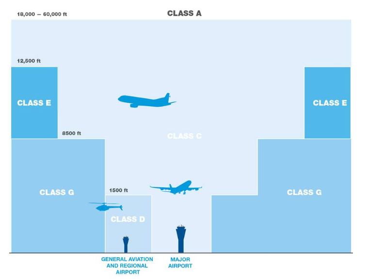
There are two types of airspace — controlled and uncontrolled.
Controlled airspace
Airservices air traffic controllers manage controlled airspace. To enter controlled airspace, an aircraft must first gain a clearance from air traffic control. In controlled airspace all aircraft must have continual radio contact with air traffic control and submit a flight plan detailing the route and height they will fly. Some emergency operations do not have to submit a flight plan, due to the urgency of their flights.
Uncontrolled airspace
All other airspace is uncontrolled. No clearance is required to operate in uncontrolled airspace and there is no supervision by air traffic control. Pilots operating in uncontrolled airspace must still comply with aviation regulations. However, they do not need to submit a flight plan and they may only have partial radio contact. The large majority of light aircraft and helicopters operate mostly in uncontrolled airspace.
Because aircraft must take off and land into the wind for safety reasons, the runway selected for use will be the one that allows “into-wind” operations.
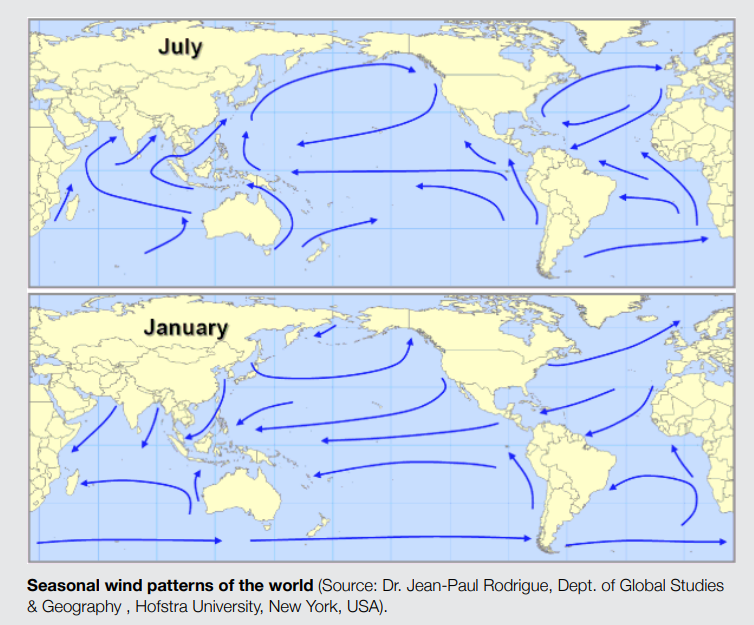
Wind patterns tend to be seasonal. This means that at some times of the year a runway and its associated flight paths may receive more use than at other times of the year.
The following image outlines the seasonal wind patterns and how they vary around Australia.