Learn about flight paths and aircraft movements in your area
Welcome to the Aircraft in Your Neighborhood Portal
Our goal is that you will learn more about the flight paths and aircraft movements in your area and be able to access the information and resources that explain how air traffic is managed.
First, please select your location using one of the following options, so that we can customize the information for your location.
We’ll remember your location so you don’t have to enter it every time you visit the site and we’ll keep this information confidential.
Please note, that this site works best on Chrome, Firefox and Edge.
* Mandatory - Select region first to view the map.
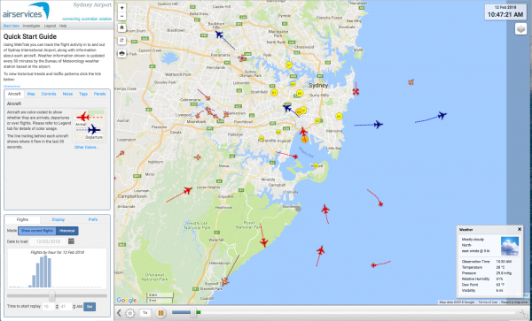
WebTrak is a tool that enables the community to see where aircraft fly and explore historical trends and patterns. WebTrak is provided by Envirosuite.
WebTrak uses information from air traffic control radars to display aircraft movements. The flight search and display function allows you to view aircraft flight activity over metropolitan areas. You can also:
locate your street address and have your home appear on the map
see noise levels of individual aircraft
view information about aircraft type, height, origin and destination
display an aircraft’s flight path and point of closest approach to your home
zoom in and out down to street level.
Note that there is a slight delay on the display of flights.
Every major airport has Noise Abatement Procedures (NAPs), which are procedures designed to reduce the impact of aircraft noise on the community. There are some limitations to the use of NAPs and they may not be used if they generate delay and congestion, as this can cause noise and emission impacts. Air traffic control or pilots may not be able to use them in certain situations, for example weather conditions or operational requirements.
Under the NAPs, the preferred runway for jet aircraft at Sunshine Coast Airport is Runway 31 for landing and Runway 13 for take-off.
During the operating hours of the air traffic control tower, controllers will determine the runway direction in accordance with operational requirements and other factors, such as the NAP.
When the tower is closed, the pilot will determine the best runway to use and will take consideration of any request by airport management. When operationally possible to do so, they will also apply the NAP.
The NAPs also specify that aircraft above 5,700 kilograms in weight, should track via approved flight paths when arriving and departing the airport.
Between the hours of 11pm and 5:30am, aircraft above 5,700 kilograms require prior approval from Sunshine Coast Airport to land or take-off from the airport.
Aircraft below this weight do not require prior approval and are permitted to operate at any time.
Fly Neighbourly Advice or Fly Neighbourly Agreements are voluntary agreements established between aircraft operators and communities or authorities (normally airports or local councils) to assist in reducing the impact of aircraft noise on local communities. Sunshine Coast Airport has a voluntary Fly Neighbourly Program which encourages pilots to fly in a noise sensitive way whenever possible.
There are a number of factors that influence the frequency of flights.
Firstly, the number and frequency of flights will vary on a daily, weekly and yearly basis due to differences in airline schedules. The airlines schedule flights in response to consumer demand. This is particularly the case around Christmas, Easter, school holidays and Lunar New Year.
Secondly, the runway in use at any given time will also vary, largely due to the wind conditions. Each runway has its own set of flight paths, and each flight path will affect different areas. As the runway in use changes, the flight paths change, and so too do the areas affected by aircraft movements.
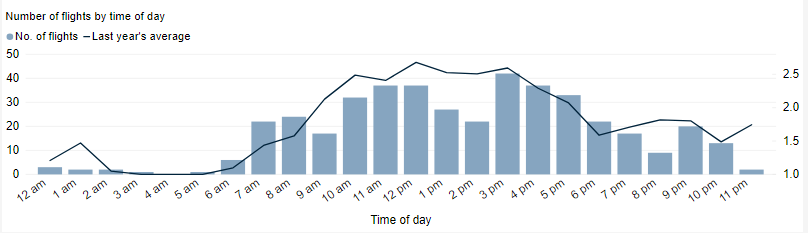
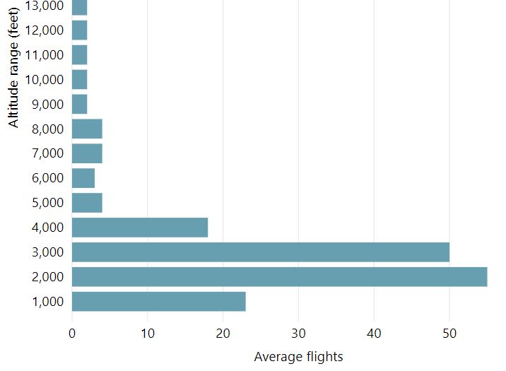
This chart shows the total number of flights each hour over the month, compared to the average for last year. Change the selected month to see how it has varied.
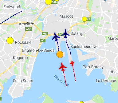
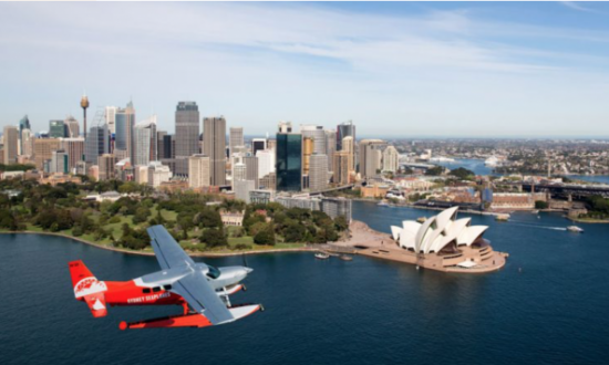
Sydney Harbour is a busy tourist precinct in the air as well as on the ground and there is growing demand for scenic flights. A harbour lane is available for the use of helicopters and seaplanes by day. This lane has been created so that harbour flights can occur without interfering with Sydney Airport arrivals and departures.
The lane follows the Parramatta River from Silverwater to Ryde Road Bridge, Gladesville Bridge, the southern pylon of the Harbour Bridge, past Bradley’s Head and Middle Head, Sydney Heads and then coastal to Long Reef.
Altitudes are restricted to a maximum of 500 feet at some points and 1,000 feet east of the Harbour Bridge. This is to ensure traffic in the lane remains outside controlled airspace. This means aircraft cannot fly higher without contacting air traffic control and receiving clearance to do so.
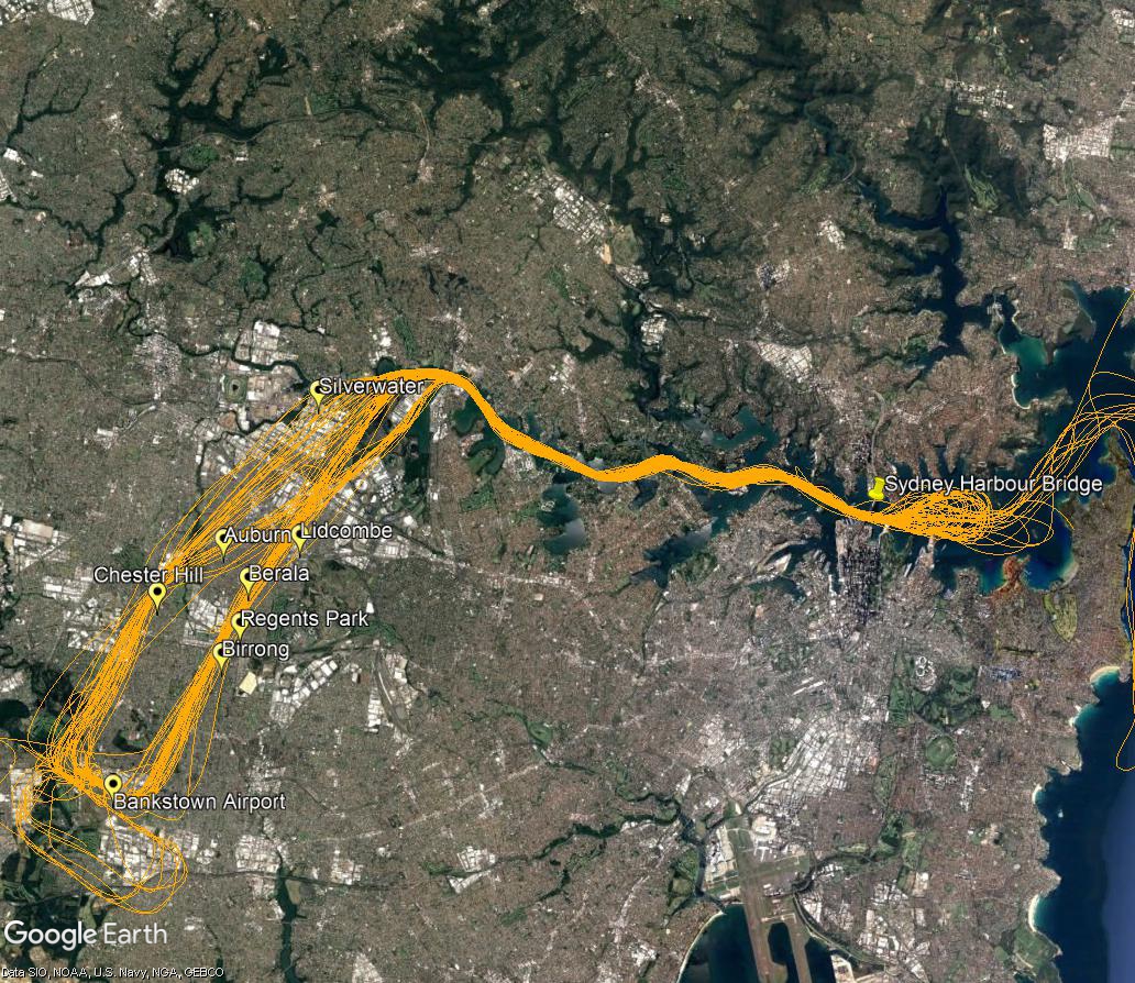
Wide view
The following image shows were most of these flights originate from and fly to reach the river.
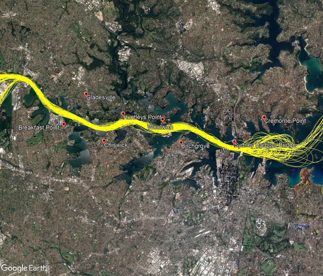
Close in
A closer view of the route over the river is shown below.
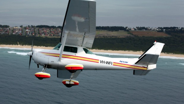
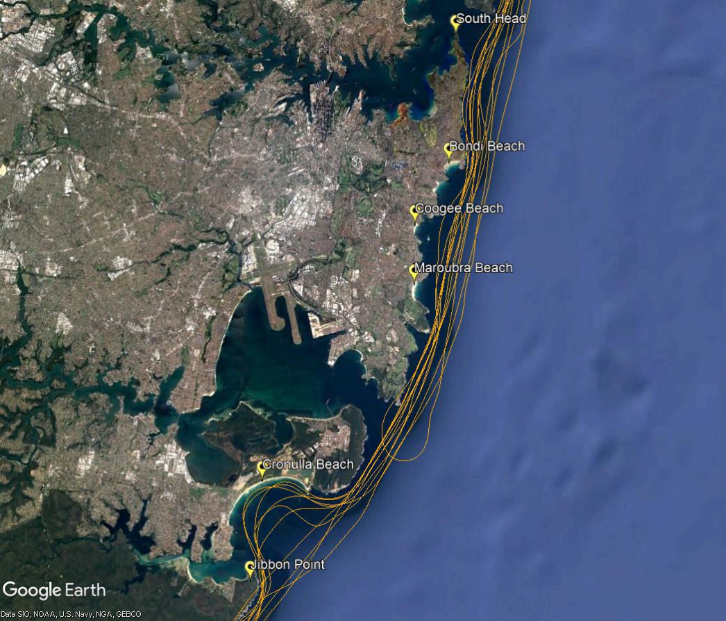
Light aircraft routes extend along the coast line, both to the south and north of Sydney as follows
South Route
The southerly route extends between Jibbon Point and South Head. On this route an altitude of exactly 500 feet must be maintained to ensure there is no conflict with aircraft arriving and departing Sydney Airport.
North Route
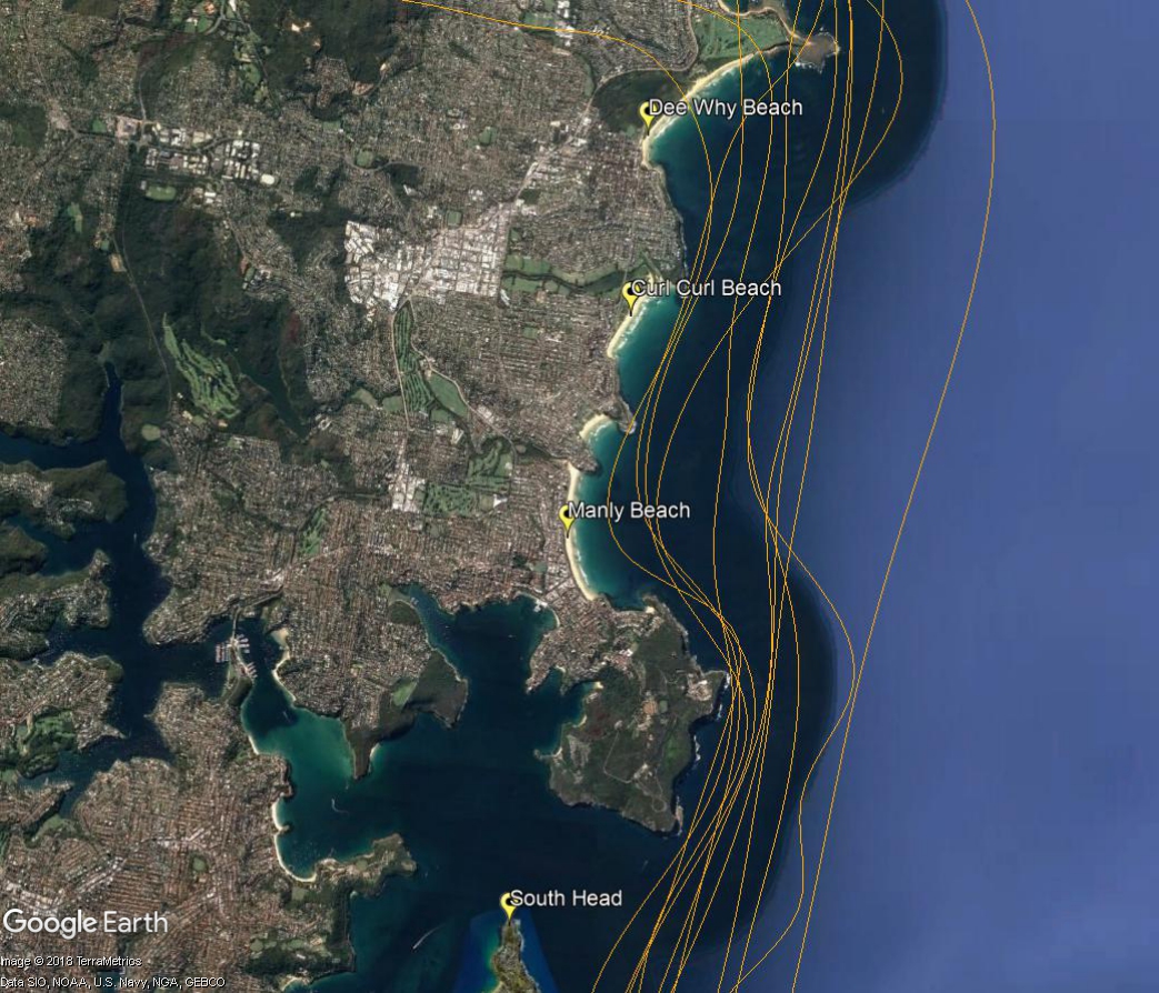
The northerly route extends east of the coast between the South Head of the Harbour and north to Dee Why. On this route aircraft must remain between 500 and 1,000 feet.
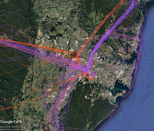
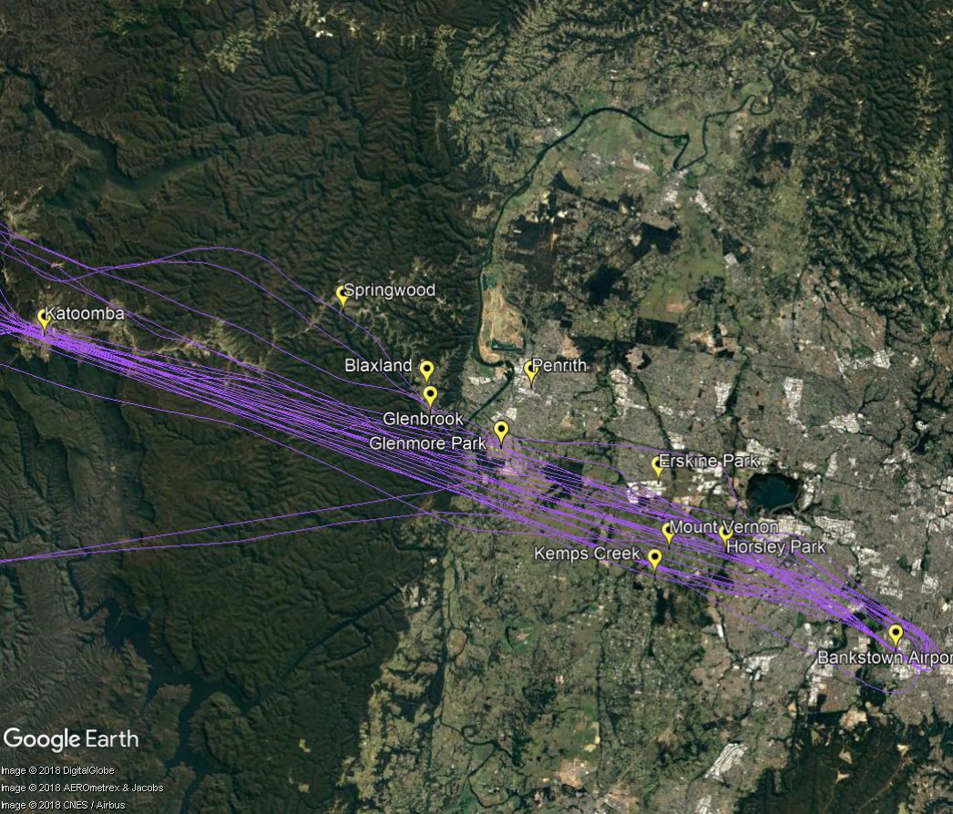
There are a number of routes around Sydney used by light aircraft and helicopters.
It is not mandatory that light aircraft and helicopters fly on these routes. As you will see from the images below which show the tracks of actual flights, some aircraft may fly the whole route but others may only fly part of it, joining or leaving it depending on their purpose or destination. Other aircraft may not use the routes at all.
These routes are mainly outside controlled airspace (“OCTA”), that is, aircraft are not being directed by air traffic control. Whenever they fly outside controlled airspace, pilots are following the rules of the air. Our booklet, Guide to our Operations, explains more about different types of airspace.
Pilots using these routes are usually flying under Visual Flight Rules, which means they navigate using landmarks that are easily seen from the air. This does not mean they must fly over each landmark; rather, they use each landmark to be sure of their position.
Most of these routes lead to and from Bankstown Airport, as shown in the images above and below.
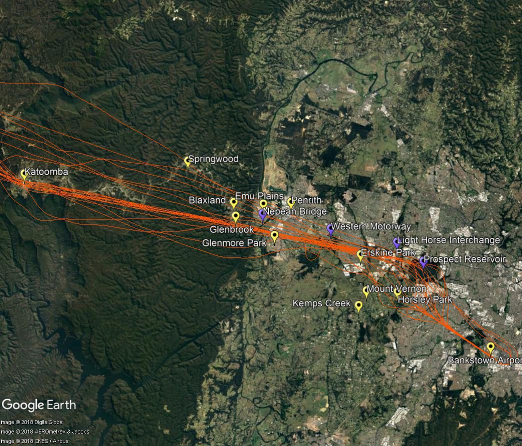
Inbound from west
Light aircraft and helicopters inbound from the west to Bankstown Airport navigate using the Great Western Highway, Nepean Bridge, Western Motorway, Light Horse Interchange and Prospect Reservoir. Pilots will usually follow the Great Western Highway over the Blue Mountains to ensure they do not stray into the restricted military airspace around Richmond RAAF Base which is located immediately to the north.
Outbound to west
When flying outbound to the west, aircraft must avoid the Richmond RAAF Base military area and will use the towns of Penrith, Glenbrook, Springwood and Katoomba as visual aids to avoid tracking into restricted airspace.
Aircraft may climb to 2,500 feet once they have passed the Liverpool to Parramatta railway line. Once west of Glenbrook aircraft may fly up to 6500 feet.
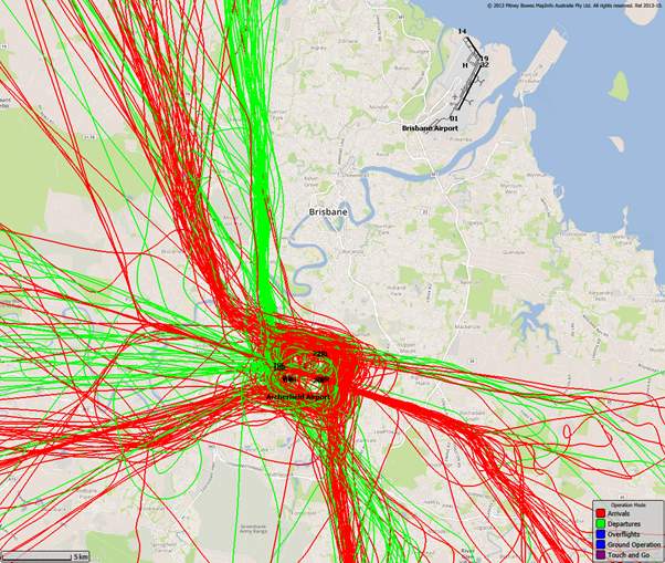
The airspace surrounding Brisbane Airport is controlled from the ground level up. The base of the controlled airspace rises moving outwards from Brisbane Airport, with the airspace below the base being uncontrolled. Light aircraft and helicopters often remain in uncontrolled airspace to remain separated from large passenger aircraft that transit through controlled airspace.
The following image shows light aircraft and helicopter movements in uncontrolled airspace throughout the Brisbane region. As you can see, these flights remain clear of Brisbane Airport:
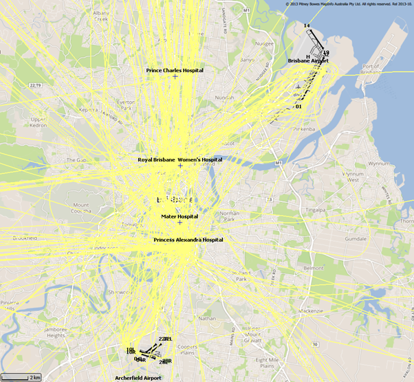
This however does not mean light aircraft and helicopters are restricted from entering controlled airspace. In order to access this airspace, the aircraft operator requires an airspace clearance and is obligated to abide by air traffic control directions once in the controlled airspace. In the Brisbane region, the most common user of this airspace apart from Brisbane Airport traffic is medical helicopters flying to and from local hospitals. The following image shows some of these flights:
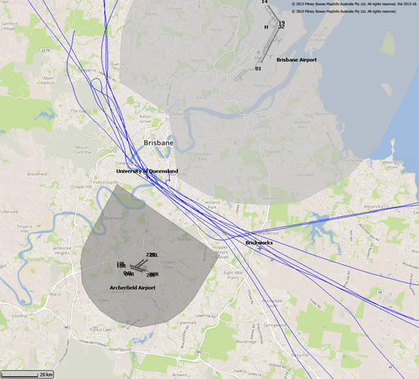
Archerfield Airport also has a pocket of controlled airspace surrounding the airport. A difference to Brisbane’s controlled airspace though is that Archerfield’s is only active from 7:00am – 5:00pm. Outside of these hours the airspace around Archerfield is uncontrolled.
In busy airspace where there is a mix of controlled and uncontrolled airspace, lanes are often established to ensure pilots transiting through the airspace remain outside of controlled airspace. One such lane passes between Brisbane’s and Archerfield’s control zones. The following image shows aircraft using this lane. The control zones for Brisbane Airport and Archerfield Airport are shaded grey. Pilots navigating along these lanes do so with visual reference to landmarks that are easy to recognise from the air which in this case is the University of Queensland and the brickworks in Rochedale. Both of this places are referenced on the map:
There are a number of routes around Sydney used by light aircraft and helicopters.
It is not mandatory that light aircraft and helicopters fly on these routes. As you will see from the images below which show the tracks of actual flights, some aircraft may fly the whole route but others may only fly part of it, joining or leaving it depending on their purpose or destination. Other aircraft may not use the routes at all.
These routes are mainly outside controlled airspace (“OCTA”), that is, aircraft are not being directed by air traffic control. Whenever they fly outside controlled airspace, pilots are following the rules of the air. Our booklet, Guide to our Operations, explains more about different types of airspace.
Pilots using these routes are usually flying under Visual Flight Rules, which means they navigate using landmarks that are easily seen from the air. This does not mean they must fly over each landmark; rather, they use each landmark to be sure of their position.
Most of these routes lead to and from Bankstown Airport, as shown in the images above and below.
To and from the north
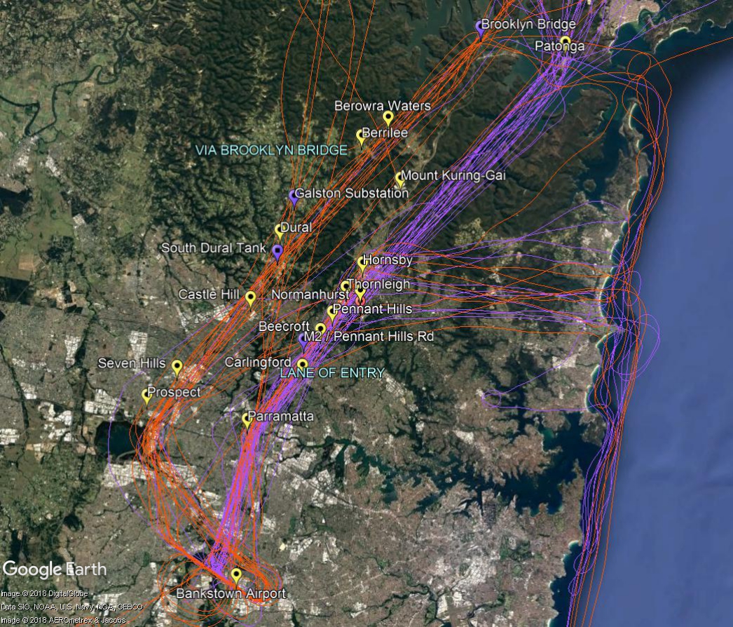
The two northern routes are shown in the image below. One is via Brooklyn Bridge, the Galston electricity substation, the water tank at South Dural and Prospect Reservoir.
The other route is a designated “lane of entry” that allows aircraft to come and go from Bankstown Airport without entering the controlled airspace of Sydney Airport or Richmond RAAF Base. It is also used by aircraft transiting from north of Sydney to areas south and south west of the city. This corridor of airspace has a ceiling height of 2,000 to 2,500 feet.
The lane of entry runs between Bankstown Airport and Patonga. Outbound aircraft head to Parramatta and past the Prospect to Potts Hill pipeline. Once north of the pipeline aircraft can climb to 2,000 feet. Tracking features include the intersection of the M2 and Pennant Hills Road, the strobe light at Pennant Hills CBD, a covered reservoir at Thornleigh and the Hornsby CBD and railway sheds. The track then follows the eastern side of the M1 motorway (Sydney Newcastle Freeway) and onwards to Patonga.
Aircraft may turn east from the lane at Hornsby and travel towards the coast using the Baha’i Temple as a tracking feature. Once at the coast aircraft may track to Long Reef or conduct a harbour scenic flight or coastal flight.
In the image below the tracks of inbound aircraft are shown in orange and outbound are purple.
We have assembled a list of our commonly asked questions that are asked in most areas.
Why can aircraft fly at sensitive times?
Aviation is a vital industry for the Australian economy. Business, tourism, social and freight activities rely on aviation. Unlike many other industries, aviation is regulated by the federal government rather than by state governments. This makes aircraft noise regulation quite different from the type of noise regulation you are used to at a local level that might, for example, prohibit noisy activities before 8:00 am on a Sunday.
Major airports in Australia are situated very close to residential areas and for this reason it is not possible to design flight paths that avoid flying over homes. In cities where the airport is located on the coast, flight paths will be designed to fly over water wherever possible. However because aircraft must take off and land into the wind, it is not always possible to avoid flying over residential suburbs by staying over water.
Aircraft noise remains a key challenge for an industry that is forecasting high levels of growth in air traffic movements over the next 20 years. Managing noise impacts on communities requires careful balance between the protection of affected residents and recognition of the broader economic and social contributions of the aviation activity.
Why can’t the flight paths be moved away from me?
Flight path design is a complex process. Flight paths must comply with international design standards and Australian safety regulations. Changes to flight paths may be made for a variety of reasons, including safety and noise management. However, changes are not easy to make as changes to one flight path usually impact other flight paths.
In considering any change, first of all we must have regard to safety – any change that could compromise safety cannot be progressed. Managing aircraft in a regular way and minimising complexities are central tenets of safety. We also consider the efficient operations of the airport and whether there would be an overall noise improvement for the community. We do not generally consider that moving noise from one part of the community to another is a noise improvement. In considering this we have to have regard to the entire flight path and the fact that moving it at one point may result in adverse effects many kilometres away. Unfortunately, the reality is that it is very difficult to identify flight path changes in metropolitan areas that can be made without moving the noise, or compromising safety or efficiency.
If a potential change is identified it must be environmentally assessed, the community, including potentially affected areas, the airlines and other stakeholders must be consulted and feedback from all must be considered. Finally, if the change is to go ahead, aeronautical documents for pilots must be produced and published and time allowed for crews and air traffic controllers to be trained in the new procedures. All these requirements mean that changes can take several years to make.