How high are aircraft near me?

The altitudes of aircraft over your area can vary according to:

  • the airport the flight is coming from or going to
  • whether the aircraft is arriving, departing or in level flight
  • the specific requirements of the flight path
  • the need for air traffic control to maintain vertical separation between aircraft.

Find out more on our What are the rules about altitudes? page.

How many aircraft fly near me?

This tool shows the number of flights each day over your area in the selected month compared to the average for last year.  The bottom axis shows the day of the month. Use the drop-down menu to change the selected month to see how movements have varied. Hover over each day to see flight numbers.

Brisbane noise monitoring report

As part of the Brisbane Noise and Flight Path Monitoring System (NFPMS), Airservices monitors noise levels in areas surrounding Brisbane airport using 16 noise monitors (both long-term and short-term; this number can vary depending on any active airspace/flight path changes). We strategically deploy noise monitors at various locations around the greater Brisbane region to capture data from aircraft operations in differing phases of flight. More information on the Brisbane NFPMS is available here

Noise monitor data is publicly available on WebTrak, for community members to see the noise level of aircraft as they pass over the monitors. There is currently a 3-minute delay in providing information and we are working to reduce this time.

The below interactive tool provides a monthly report for each long-term noise monitor.

The tool is best viewed in full screen mode. To familiarise yourself with the tool, we advise that you click on the ‘Click here for Help’ button on the bottom right of the tool before use.

Brisbane Airport noise abatement

Noise Abatement Procedures

Every major airport has Noise Abatement Procedures (NAPs), which are procedures designed to reduce the impact of aircraft noise on the community. There are some limitations to the use of NAPs and they may not be used if they generate delay and congestion, as this can cause noise and emission impacts. Air traffic control or pilots may not be able to use them in certain situations, for example weather conditions or operational requirements. 

The main Noise Abatement Procedures currently in use at Brisbane Airport are:

Preferred runways

Air traffic control nominates the runway for use to ensure safety and operational requirements are met, depending on the weather conditions. If weather conditions do not favour a specific runway, the ‘preferred’ runway is used, two of the main points are set out below.

  • From 6 am to 10 pm, providing wind and traffic management safety requirements permit, arrivals over Moreton Bay and departures over Brisbane suburbs from Runway 19 L/R is the preferred option.
  • From 10 pm to 6 am, providing wind and traffic management safety requirements permit, Simultaneous Opposite Direction Parallel Runway Operations (SODPROPS) are used to enable aircraft to depart and land over Moreton Bay, arrivals onto Runway 19R and departures on Runway 01R.

If the downwind in the southerly direction exceeds 5 knots or there is downwind and the surface is wet, to comply with runway selection criteria, northerly runway direction operations will be nominated. Aircraft will then land over the city and depart over the bay. If conditions change quickly and the forecast suggests it may continue to change, a change of runway direction may not occur immediately or at all, if our air traffic controllers are satisfied that the runway selection criteria is adhered to.

Reciprocal runway operations

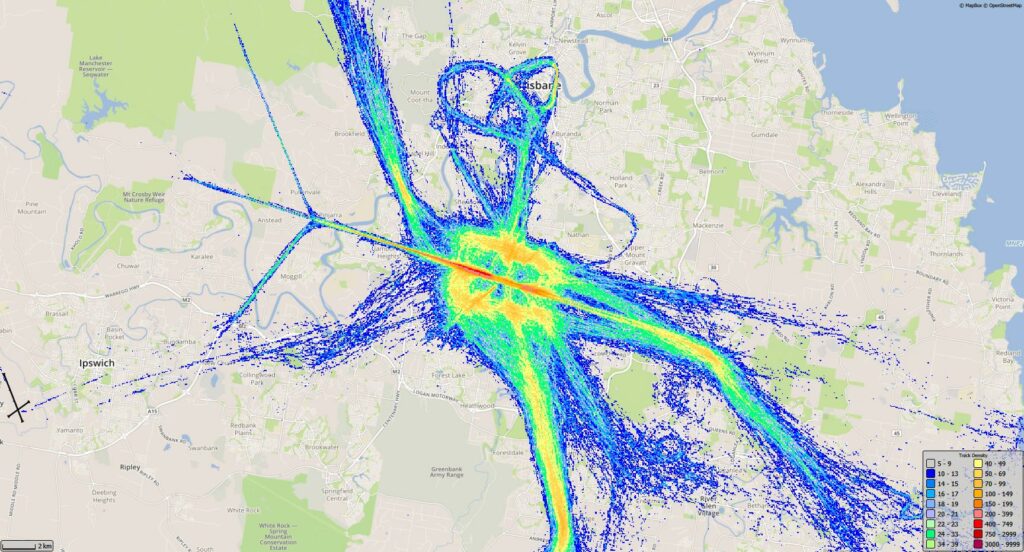
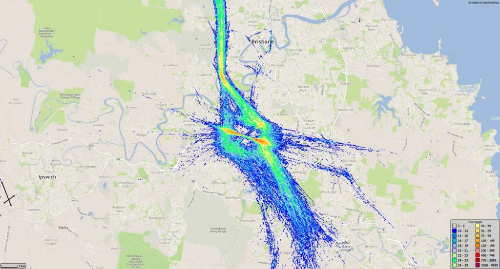
During night operations (10 pm to 6 am) Simultaneous Opposite Direction Parallel Runway Operations (SODPROPS) is the preferred operating mode. SODPROPS sees all aircraft operate over the bay by using one runway for departures and the other for arrivals.

To operate SODPROPS visibility must be eight kilometres or greater, the cloud base must be 2500 feet or higher, the downwind must be less than 5 knots and the runway surfaces must be dry.

If SODPROPS cannot be used, the NAPs specify that the southern end of the new runway should not be used during the night period.

Using SODPROPS during day operations

SODPROPS sees all aircraft operate in the same airspace. This means aircraft are ascending and descending in the same airspace and regularly crossing flight paths. This complexity prohibits the use of SODPROPS during busy periods which tends to be throughout the day period. Our air traffic controllers will use SODPROPS during day operations when possible however the traffic density often precludes this. At this time, while traffic numbers are lower than expected, we tend to see the SODPROPS mode maintained after 6am and commence prior to 10pm.

Intersection departures

The NAPs specify that aircraft heavier than 30 000 kilograms cannot use an intersection departure, except when complying with certain ICAO requirements.

Any aircraft below this weight can use an intersection departure and will do so if necessary.

Intersection departures are not permitted by any aircraft between 10pm and 6am, with the exception of a limited number of turbo-prop aircraft from 5am.

Temporary NAP

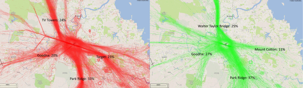
We will implement a temporary Noise Abatement Procedure to adjust the turbo-prop traffic spread to match what would have been experienced had COVID-19 not affected traffic volumes. This will increase operations in the areas between the short and long approaches (the swathe) during periods of high demand, while the shorter visual approach will still occur when traffic volumes are generally lower.

This temporary procedure will be in place until operations increase to both runways, which will then result in a similar traffic management outcome – with more aircraft operating within the ‘swathes’.

Learn more about turbo-prop operations during COVID-19 on our How do turbo-prop aircraft fly? page.

Brisbane Airport flight paths

New flight paths commenced at Brisbane Airport on 12 July 2020. You can find out more about the new flight paths on our When is each flight path used page.

To learn more about the runways at Brisbane Airport, take a look at our Brisbane Airport Runways page.

The illustration below shows how aircraft typically operate following the new runway opening.

Some changes were made to departure flight paths on 28 November 2024. The North East Flow image below has been updated to reflect these changes. You can view the flight path changes on the Noise Action Plan for Brisbane | Engage Airservices page.

The animation is indicative only and provided for information purposes, on occasions flights may leave these general areas from time-to-time.

Archerfield Airport flight paths

Archerfield Airport is a large general aviation airport catering for charter flights, flight training, aircraft maintenance and emergency response units, both fixed wing and helicopters.

Archerfield Airport operates 24 hours a day, seven days per week. It is Brisbane’s secondary airport and Queensland’s major centre for general aviation activities.

Noise abatement measures are taken on the ground such as designated run-up bays and specific helicopter landing areas.

Flight paths

The majority of aircraft using Archerfield Airport fly under Visual Flight Rules (VFR). There are designated routes for VFR aircraft to ensure that VFR traffic remains separate from aircraft flying under Instrument Flight Rules (IFR). It is not mandatory that VFR aircraft fly these routes, but many do, especially as they approach or depart airports. These routes are outside controlled airspace.

VFR routes include defined entry and exit points to and from controlled airspace. These are landmarks that are easily seen by the pilot from the air. These landmarks are highlighted in the images below, which also show the average percentage of arrivals or departures that use the route.

There is no minimum altitude for aircraft in the process of landing. Aircraft will generally descend on a glide slope of three degrees.

The altitude of aircraft after departure will depend on factors such as the type of aircraft and its weight, how heavily laden it is with fuel and passengers, and the atmospheric conditions at the time. All these factors affect an aircraft’s climb rate. There is no regulated minimum altitude for an aircraft in the process of taking off.

The below images are an example of standard flight paths into and out of the airport on a normal day.

Arrivals and Departures for Archerfield, showing the visual landmarks used by pilots.

Shown below are track densities for Archerfield from January to March 2020. A track density is generated by overlaying a grid on the map, and coloring that grid based on a count of how many operations passed through each grid square. Cooler colours are used for low counts, and warmer colours for high traffic.

Archerfield Arrivals, Jan-Mar 2020
Archerfield Departures Jan-Mar 2020

Short Term Monitoring – Completion reports

Airservices maintains a short-term noise monitoring program around the greater Brisbane region to:

  • support airspace/flight path change reviews with quantitative data, by comparing pre-and-post-change levels
  • calibrate noise models
  • respond to requests from the Brisbane Airport Community Aviation Consultation Group (BACACG) or other community requests for noise monitoring data in specific areas.

Noise monitors are sited in areas that effectively capture noise data from the aircraft that are the focus of the monitoring program. The decisions on final locations of monitors take into account a number of other factors, including security, licensing, facilities and background noise levels. These decisions are made by Envirosuite (the global noise monitoring specialists contracted by Airservices).

Following deployment of a short-term noise monitor, Envirosuite provide a comprehensive report detailing the findings of the deployment.

Please find links below to download Brisbane short-term noise monitoring completion reports (all reports are provided as PDFs):

Brisbane Airport Corporation has conducted temporary noise monitoring around Brisbane to supplement the Airservices noise monitoring program. They have completed monitoring at:

  • Balmoral Hill (30 July – 8 October 2021)
  • Upper Brookfield (25 October 2021 – 14 January 2022)
  • Cedar Creek (7 February – 11 April 2022)
  • Coorparoo (19 May – 1 July 2022)
  • Redlands Noise Monitor including Wellington Point and Thornlands (13 January – 30 April 2023)
  • Taringa (30 May – 14 August 2023)
  • The Gap (1 November 2023 – 2 April 2024)

To view their reports click here.