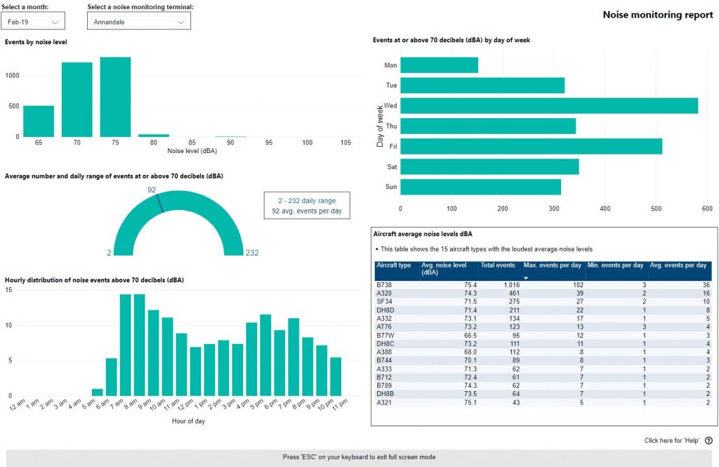
Use this interactive tool to explore monthly noise monitoring data.
This report is best viewed in full screen mode.
To learn more about noise monitor terminal locations visit our Adelaide Noise and Flight Path Monitoring System page.
Use this interactive tool to explore monthly noise monitoring data.
This report is best viewed in full screen mode.
To learn more about noise monitor terminal locations visit our Adelaide Noise and Flight Path Monitoring System page.
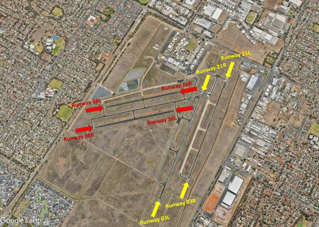
At Parafield Airport there are two sets of parallel runways. One set is orientated east to west (Runways 08 Left/26 Right and 08 Right/26 Left) and the other is orientated north to south (Runways 03 Left/21 Right – 03 Right/21 Left).
Each runway is referred to differently according to in which direction it is being used. For example, the north-south runways are referred to as Runway 03 Left and Right when used in a northerly direction and Runway 21 Left and Right when used in a southerly direction.
Runway numbering reflects the runways’ orientation and correlates with degrees on a compass. Runway 03 is 30 degrees magnetic.


The following video explains how runways are named and used.
Runway selection is based on wind direction, weather conditions, traffic volume and other factors. See the Runway Selection fact sheet for more details. Aircraft primarily take-off and land into the wind for safety and performance reasons. Therefore, as the wind direction changes the runway in operation may also change depending on the strength of the wind.
This means that Adelaide’s seasonal wind patterns affect usage of the different runway directions. For example, Runways 03 Left and Right tend to be used more often in the cooler months when there are frequent winds with a northerly component. Runways 21 Left and Right tend to be used more frequently in the warmer months when the predominant wind direction tends to be southerly.
Noise abatement procedures are designed to help reduce the impact of aircraft noise on communities. While they are applied whenever it is possible to do so, their use is not mandatory and is subject to weather conditions and traffic requirements.
Circuit training is only allowed between specific hours. At night, circuit training can only be conducted from the north-south runways to the west. Outside of Tower hours the preferred runway is 03 Left/21 Right.
The majority of aircraft using Parafield Airport fly under Visual Flight Rules (VFR). There are designated routes for VFR aircraft to ensure that VFR traffic remains separate from aircraft flying under Instrument Flight Rules (IFR). It is not mandatory that VFR aircraft fly these routes, but many do, especially as they approach or depart airports.
These routes are outside controlled airspace (“OCTA”), that is, aircraft are not being directed by air traffic control. Whenever they fly outside controlled airspace, pilots are following the rules of the air. More information about airspace is found here.
VFR routes include defined entry and exit points to and from controlled airspace such as that around Parafield Airport. These are landmarks that are easily seen by the pilot from the air. These landmarks are highlighted in the images below, which also show the average percentage of arrivals or departures that use the route.
There is no minimum altitude for aircraft in the process of landing. Aircraft will generally descend on a glide slope of three degrees.
The altitude of aircraft after departure will depend on factors such as the type of aircraft and its weight, how heavily laden it is with fuel and passengers, and the atmospheric conditions at the time. All these factors affect an aircraft’s climb rate. There is no regulated minimum altitude for an aircraft in the process of taking off.
The VFR arrival route from the northwest begins at Dublin. Aircraft will be at or below 4500 feet at this point. The route crosses the coast at River Mouth by which time aircraft must not be above 1500 feet. The route then tracks over water to the entry point at Outer Harbor.
From the east aircraft track via Warren Reservoir where they will be below 2500 feet to Little Para Reservoir Dam Wall entry point where they need to be 1500 feet.
From the south the VFR route begins at Tailem Bend and tracks via Strathalbyn where aircraft will be below 4500 feet. It then proceeds to Port Noarlunga where aircraft will stay below 2500 feet. From there aircraft will track up the coast to the Marino Lighthouse. Aircraft will now be at 1500 feet as they fly past the Mitsubishi Car Plant to the Waite Campus of Adelaide University, and then to Hope Valley Reservoir entry point.
Outer Harbor and Little Para Reservoir Dam Wall are the most used entry points.

The VFR exit points are Port Adelaide, St Kilda, Para Substation and Hope Valley Reservoir. St Kilda and Para Substation are the most-used exit points.
Aircraft departing to the north-west will maintain 1000 feet until reaching St Kilda to separate them from arriving aircraft at Outer Harbor which are at 1500 feet. To stay out of controlled airspace, aircraft will avoid climbing above 1000 feet until north of St Kilda. While tracking towards Dublin aircraft will climb to 2500 feet until past Middle Beach where they can climb to at or below 4500 feet.
Departures to the east are via Para Substation, past the GMH complex. Aircraft will maintain 1000 feet until clear of traffic and then climb to 1500 feet. Once clear of the Parafield Control Zone they will climb to not above 2500 feet and track to South Para Reservoir.
Departures to the south may be cleared by air traffic control on the Hope Valley Reservoir route from Waite Campus at Adelaide University to Marino Lighthouse. Alternatively they may be directed to depart via St Kilda from where further clearance to head south is required.

A designated training area exists to the north-west of the airport and to the west and north-west of the RAAF Edinburgh Base. Once pilots progress past the circuit training stage of their courses they will begin flying to and around the training area.
The training area is outside controlled airspace. It extends from St Kilda, which is approximately 10 kilometres west-north-west of the airport, to Long Plains, which is a further 45 kilometres to the north-west of St Kilda. The training area is to the west of this line and extends to 9 kilometres off the coast. It is ‘wedge-shaped’ because it is located in-between military restricted airspace to the west and north and the RAAF Edinburgh Base Control Zone to the east.
From the St Kilda area to just south of Middle Beach the training area exists between the surface (“SFC”) and 2500 feet. North to Long Plains the area extends between the surface and 4500 feet. These levels keep the aircraft below controlled airspace; therefore aircraft do not need a clearance from air traffic control to operate in the training area.
Aircraft wishing to track to the training area from Parafield Airport must remain south of the Bolivar strobe light and west of St Kilda to remain outside controlled airspace. The north- and southbound VFR routes (described above) transit the area.
Activities that may occur inside the training area include parachute operations and light aircraft movements at Lower Light aircraft landing area, as well as training flights by light aircraft in and around the area and aircraft transiting on the north and southbound VFR routes. There can be increased traffic volumes in the area due to use by flight training companies from Parafield Airport and because all aircraft are confined to a relatively small area due to the surrounding military airspace including RAAF Base Edinburgh.

Flight paths are not precise, defined paths like runways, but more like corridors that are often several kilometres wide.
Arriving aircraft will line up with the runway centreline and fly straight in on the runway heading. Therefore suburbs in line with the runway will be overflown by arriving aircraft. Other suburbs will be overflown by aircraft travelling to join the final approach. Non-jets will join the final approach path closer to the airport whereas jets may join it 20 kilometres or more from the runway.
The altitude the aircraft will be at when it begins its final approach will depend on how far it has left to fly to the runway. There is no regulated minimum altitude for an aircraft in the process of landing. Aircraft will generally descend on a glide slope of three degrees.
Departure flight paths allow aircraft to maintain the runway heading for a short time until they are stabilised in flight, and then to turn towards the route that will take them to their destination. Non-jets are turned off towards their headings soon after departure and jets will generally remain on the runway heading for longer.
Jet departures from Runway 05 that are headed for ports such as Sydney and Melbourne will turn towards the south-east soon after departure around Mile End and will fly over the city and suburbs such as Eastwood, Dulwich and Glenside. Jets heading for destinations such as Brisbane, Cairns, Perth, Hong Kong, Indonesia and Malaysia will continue on runway heading over suburbs including North Adelaide, Medindie, Walkerville and Klemzig. Around Holden Hill the flight path splits with some continuing northwards and others turning westerly. Of these, some head back towards the coast, passing over suburbs such as Modbury, Gulfview Heights, and Salisbury South. Others turn north-westerly.
Some jet aircraft will be directed to turn off the runway heading sooner than others. This usually occurs for traffic management reasons to ensure that safe separation is maintained between aircraft, particularly at busy times when the volume of traffic is high.
The altitude of aircraft after departure will depend on factors such as the type of aircraft and its weight, how heavily laden it is with fuel and passengers, and the atmospheric conditions at the time. All these factors affect an aircraft’s climb rate. There is no regulated minimum altitude for an aircraft in the process of taking off.
A growing number of modern aircraft are now fitted with navigation systems that use satellite-assisted guidance which allow aircraft to fly with a higher degree of accuracy and more closely follow the same route as other aircraft. Airservices refers to these routes as ‘Smart Tracking’. Smart Tracking technology makes air travel safer, cleaner and more dependable. It also has the potential to improve noise outcomes for communities living close to airports.
You can access historical information about flight path use through WebTrak. To access this information click the “Historical” link below the text in the Quick Start Guide at the top left-hand side of the screen. Then use the tick boxes at the bottom-right of the screen to select monthly, quarterly or yearly information. Use the sliders to refine your selection to specific timeframes.

In response to complainants raising concerns about helicopter movements during the curfew, Airservices investigated all helicopter movements to and from Adelaide Airport between 1 July and 30 September 2016. The investigation found that in each case these movements were emergency services helicopters which are permitted to use the airport during the curfew period.
The curfew applies only to aircraft arriving at or departing from Adelaide Airport. Aircraft travelling between other origins and destinations are permitted to fly over Adelaide during curfew hours.
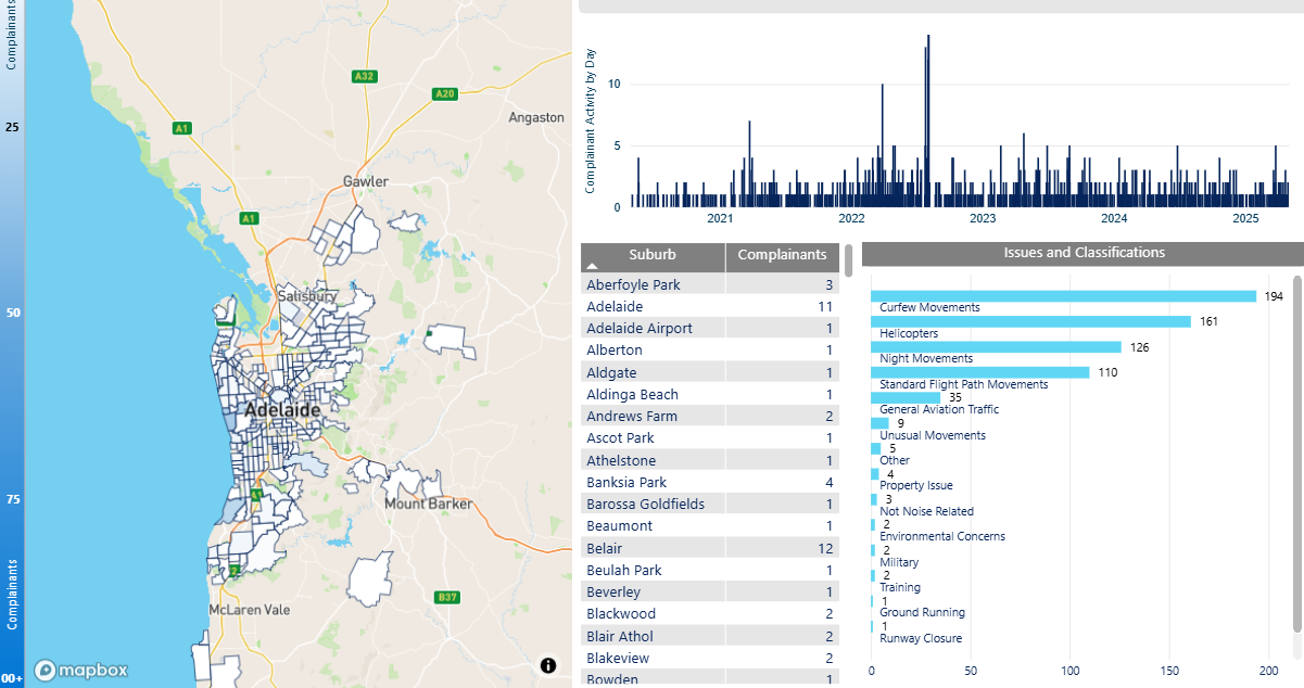
We manage complaints and enquiries about aircraft noise and operations through our Noise Complaints and Information Service (NCIS). The information below is collected for the purpose of complaint management, analysis of issues and identification of causal factors.
For this reason we refer to ‘complainants’ and ‘issues’. Complainants are people who contacted us. While some people submitted enquiries or comments rather than complaints, all are referred to as “complainants”. Issues are the primary concern they raised.
Use this interactive tool to explore the issues raised by residents from different suburbs. For help, click the button in the bottom right-hand corner.
This report is best viewed in full screen mode.
Read an explanation of issues and classifications used in complaint reporting.
Visit Engage Airservices to engage with our program of flight path and airspace changes.
Airport Master Plans provide a blueprint for the future development of an airport over a twenty year period. They include information on forecast growth, airport terminals and facilities, runways and flight paths.
Airports are responsible for producing the master plan.
The Adelaide Airport Master Plan can be found on the Adelaide Airport website.
The Parafield Airport Master Plan can be found on the Parafield Airport website.
Aircraft usually take-off and land into the wind for safety and performance reasons. As the wind direction changes the runway in operation and the flight paths being used may also change.
This means that Adelaide’s seasonal wind patterns affect usage of the different runway directions. The prevailing wind is southerly for most of the year, meaning that Runway 23 is used the most frequently. During the cooler months Runway 05 typically receives more use than at other times of the year because there tends to be more northerly winds.
If the wind is light or calm the direction the runway is used is determined by other factors such as Noise Abatement Procedures (NAP) or air traffic management requirements.
As we gather more data on operations we will update this section with more information.
Learn more about how the runway is named and oriented on our Adelaide Airport Runways page.