Essendon Airport Runways

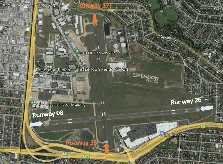
Essendon Airport has two intersecting runways, one oriented north-south (Runway 17/35) and one east-west (Runway 08/26).

Each runway is referred to differently according to in which direction it is being used. For example, the north-south runway is referred to as Runway 35 when used in a northerly direction and Runway 17 when used in a southerly direction.

Runway numbering reflects the runways’ orientation and correlates with degrees on a compass. Runway 35 is 350 degrees magnetic.

The following video explains how runways are named and used.

Runway selection and seasonal winds

Runway selection is based on wind direction, weather conditions, traffic volume and other factors. See the Runway Selection page for more details. Aircraft primarily take-off and land into the wind for safety and performance reasons. Therefore, as the wind direction changes the runway in operation may also change depending on the strength of the wind.

This means that Melbourne’s seasonal wind patterns affect usage of the different runway directions. For example, Runways 35 tends to be used more often in the cooler months when there are frequent winds with a northerly component. Runway 17 tend to be used more frequently in the warmer months when the predominant wind direction tends to be southerly. Often the wind will also have a westerly component, such as a north westerly or south westerly, and for this reason Runway 26 is used frequently throughout the year.

Noise abatement procedures

A curfew that restricts both aircraft type and usage between the hours of 11pm and 6am applies. Certain classes of aircraft are permitted to operate during the curfew, including emergency services. More detail on curfew restrictions and dispensations is available on the Department of Infrastructure, Transport, Regional Development and Communications website.

Noise abatement procedures are designed to help reduce the impact of aircraft noise on communities. While they are applied whenever it is possible to do so, their use is not mandatory and is subject to weather conditions and traffic requirements.

The Essendon noise abatement procedures set out preferred runways at different times.

From 6:00 am to 11:00pm the preferred runways are:

  • for landing: Runway 26 or 17 (equally preferred), followed by Runway 35 and lastly Runway 08
  • for take-off: Runways 26 or 35 (equal), followed by Runway 17 and lastly Runway 08

From 11:00pm to 6:00am the preferred runways are:

  • for landing: Runway 17, followed by Runway 26, then 35, then 08
  • for take-off: Runway 35, followed by Runway 26, then 17, then 08

Essendon Airport Flight Paths

There are flight paths in and out of Essendon Airport for Instrument Flight Rules (IFR) aircraft and Visual Flight Rules (VFR) aircraft as explained below.

Because Melbourne Airport and Essendon Airport are in very close proximity, traffic at Essendon Airport sometimes needs to be managed in irregular ways to ensure that separation is maintained with Melbourne Airport traffic. Therefore at times you may observe aircraft flying in unusual ways.

A curfew that restricts both aircraft type and usage between the hours of 11pm and 6am applies. Certain classes of aircraft are permitted to operate during the curfew, including emergency services. More detail on curfew restrictions and dispensations is available on the Department of Infrastructure, Transport, Regional Development and Communications website.

Aircraft operating in Australia are required to meet noise standards imposed through the Air Navigation (Aircraft Noise) Regulations 201

IFR Routes

Arrivals

Aircraft will approach Essendon Airport from all directions before they join the final approach path. Most arriving IFR aircraft will use standard arrival paths but some may be “radar vectored” by Melbourne air traffic control to intercept the final approach, that is, some aircraft may be given individual headings.

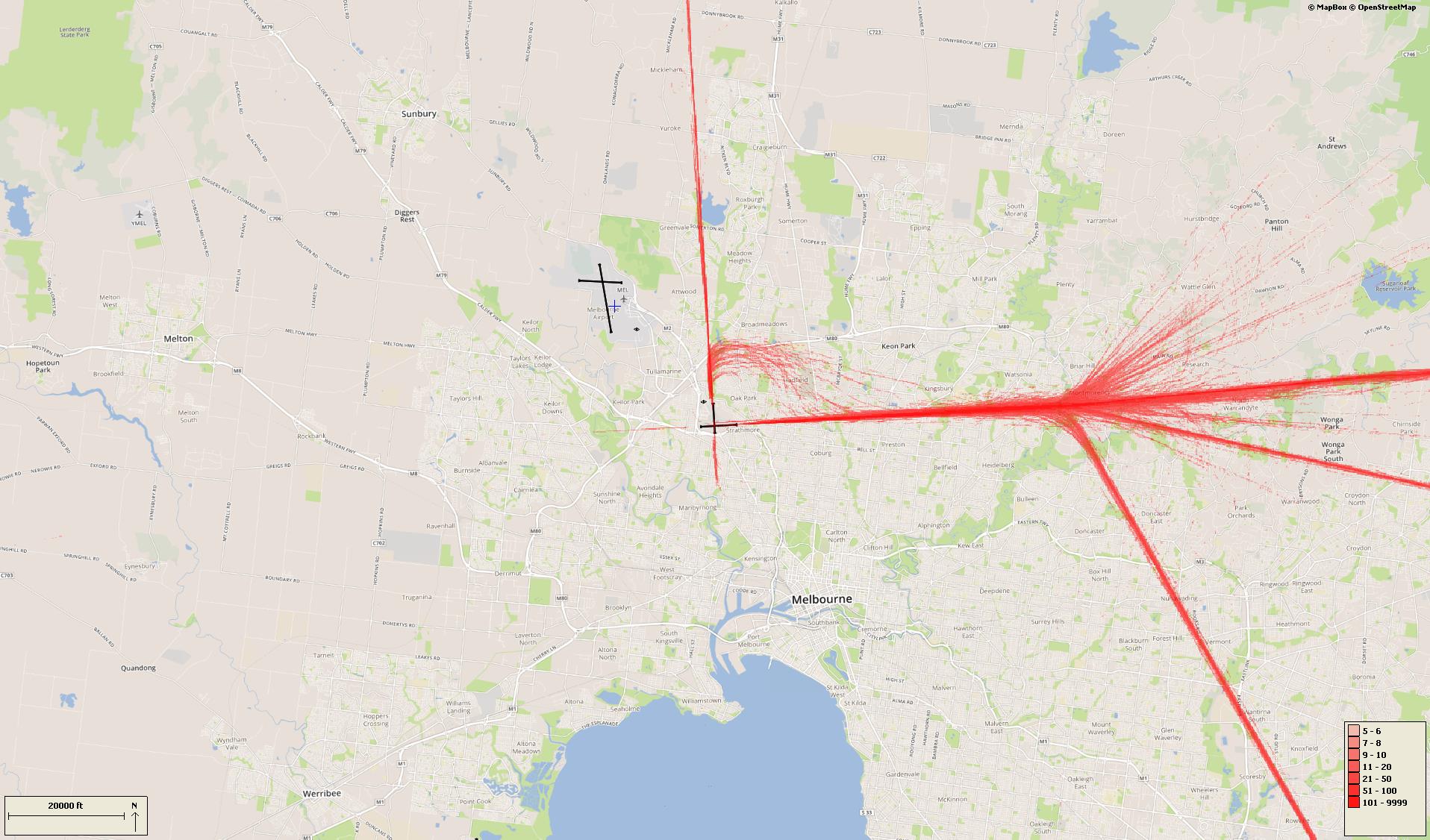
During inclement weather aircraft will usually make instrument approaches, which require the aircraft to be aligned with the runway in use 18 kilometres or more out from the airport as can be seen in the image of arrival flight paths below.

There is no minimum altitude for aircraft in the process of landing. Aircraft will generally descend on a glide slope of three degrees.

Departures

Aircraft departing Essendon Airport must be kept separated from aircraft departing and arriving Melbourne Airport. In most cases Essendon departures will be turned away from Melbourne Airport after take-off. Some aircraft may be directed to turn off the runway heading sooner than others. This usually occurs for traffic management reasons to ensure that safe separation is maintained between aircraft.

The altitude of aircraft after departure will depend on factors such as the type of aircraft and its weight, how heavily laden it is with fuel and passengers, and the atmospheric conditions at the time. All these factors affect an aircraft’s climb rate. There is no regulated minimum altitude for an aircraft in the process of taking off.

VFR routes

There are designated routes for Visual flight Rules (VFR) aircraft to ensure that this traffic remains separate from aircraft flying under Instrument Flight Rules such as jets and most commercial aircraft. It is not mandatory that VFR aircraft fly these routes, but many do, especially as they approach or depart airports.

These routes are mainly outside controlled airspace (“OCTA”), that is, aircraft are not being directed by air traffic control. Whenever they fly outside controlled airspace, pilots are following the rules of the air. More information about airspace is found here.

VFR routes include defined entry and exit points to and from controlled airspace. These are landmarks that are easily seen by the pilot from the air.

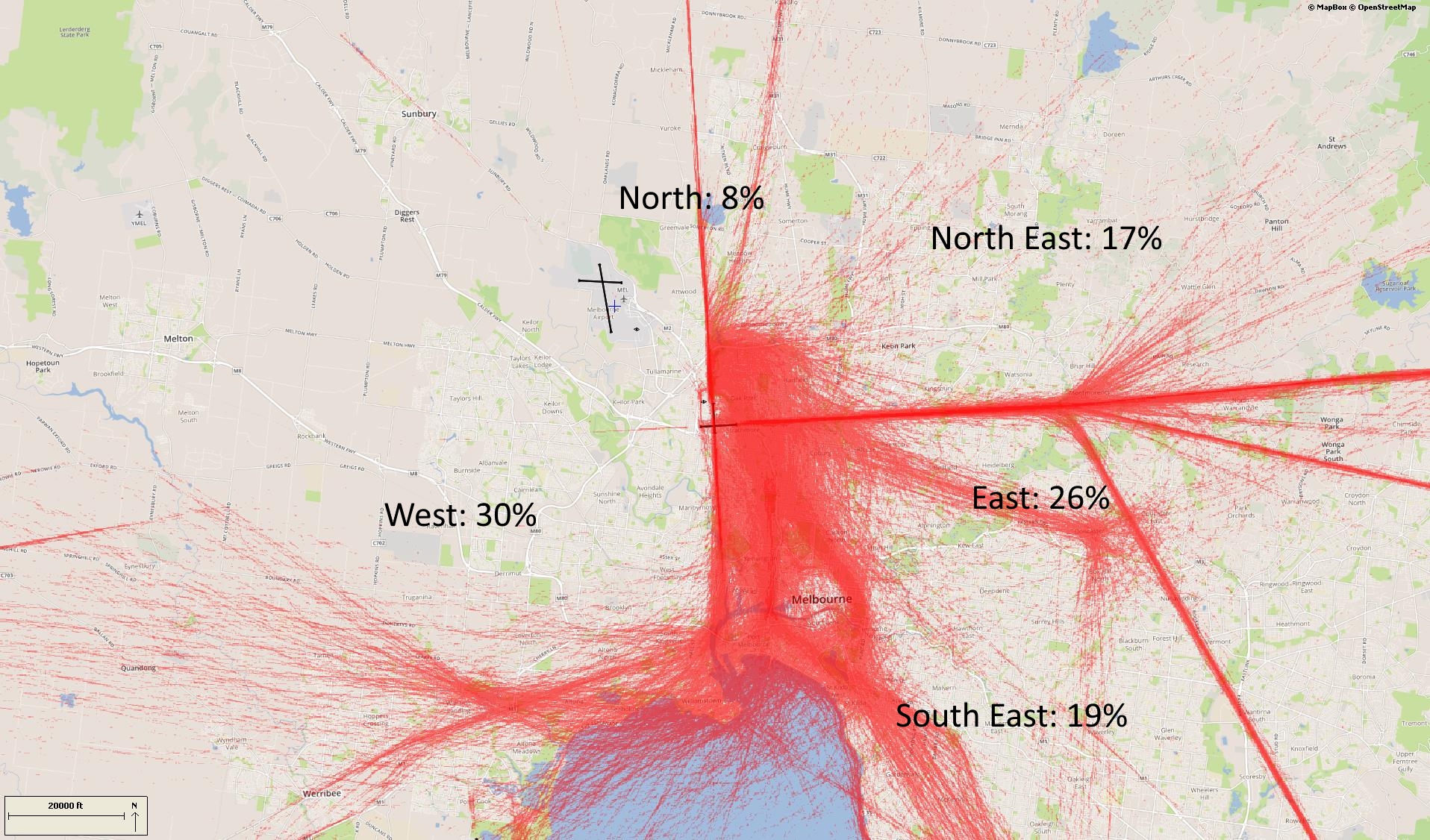
Aircraft inbound from the north may track via Craigieburn. Those from the north-east may track via Yan Yean Reservoir and Epping. When inbound from the east aircraft may track via Doncaster Shopping Centre and then either north or south of the airport or direct to the airport depending on which runway is in use.

Aircraft inbound from the south-east may track via major visual tracking points such as Albert Park and Station Pier or Westgate Bridge and then either via Moonee Valley Racecourse or direct to the airport.

From the south-west and west some aircraft will track coastal and via Laverton Bureau of Meteorological Tower, then get a clearance to track via Station Pier or Westgate Bridge and then via Moonee Valley Racecourse or direct to the airport.

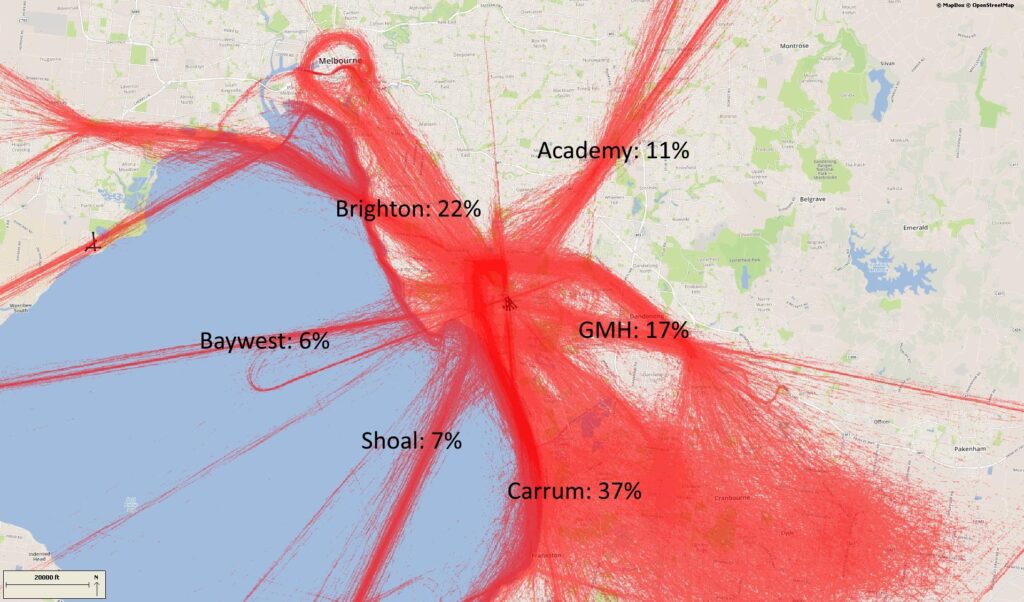
The image below shows VFR and IFR arrival routes and the average percentage each VFR route is used.

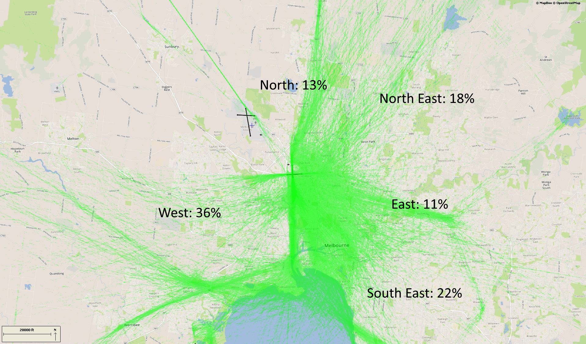
Outbound VFR aircraft will be cleared via one of the visual tracking points towards their destination.

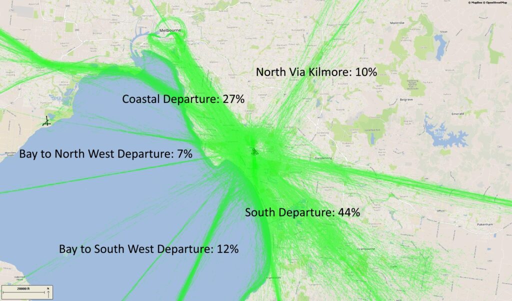
The image below shows VFR departure routes and the average percentage each is used.

Coastal route

The coastal route runs from Carrum to the south of Moorabbin Airport and around to Altona South. This allows aircraft to track around the city and the Bay while keeping outside controlled airspace and therefore not needing a clearance from air traffic control. A large number of light aircraft use this route.

Training Area

Aircraft may use the coastal route to access the training area south-east of Moorabbin Airport, or the training area near Point Cook.

Scenic helicopter routes

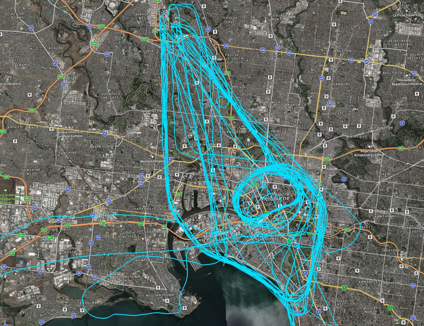
A number of helicopter and fixed wing operators conduct scenic flights from Essendon Airport and Moorabbin Airport. The main scenic route sees the aircraft flying an orbit over the area around Docklands, Eureka Tower, Rod Laver Arena, the MCG and AAMI Stadium, Exhibition Building, and Eureka Skydeck 88.

Other scenic flights head out of Essendon over Flemington Racecourse towards Port Philip Bay. This is followed by a coastal flight and then an orbit of the Docklands / MCG area. As shown in the image, above, routes can vary.

Flights are conducted at 1000 feet altitude over residential areas and 500 feet over water. Operators may choose to fly higher however in the area immediately around Essendon Airport and over the CBD passenger aircraft operate in the airspace directly above which limits the level scenic flights can ascend to.

Moorabbin Airport Runways

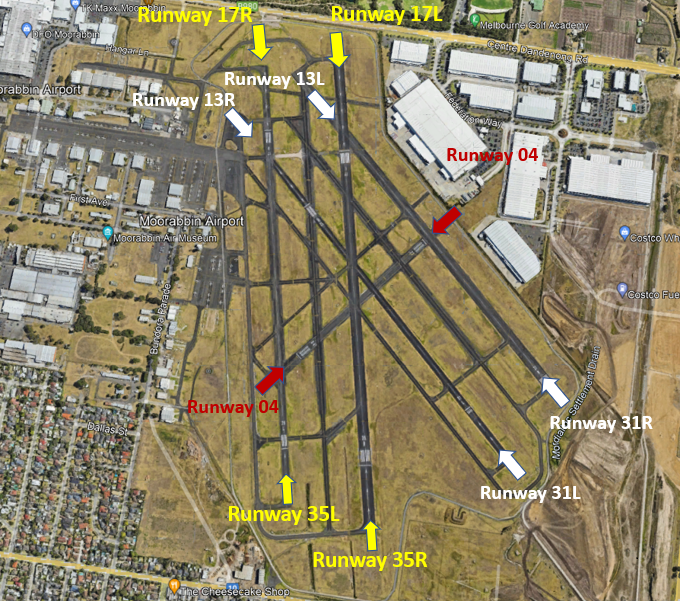
At Moorabbin Airport there are two sets of parallel runways. One set is orientated north to south (Runways 17 Left/35 Right and 17 Right/35 Left) and the other is orientated north-west to south-east (Runways 31 Left/13 Right and 13 Right/31 Left).

Each runway is referred to differently according to in which direction it is being used. For example, the north-south runways are referred to as Runway 35 Left and Right when used in a northerly direction and Runway 17 Left and Right when used in a southerly direction.

Runway numbering reflects the runways’ orientation and correlates with degrees on a compass. Runway 35 is 350 degrees magnetic.

The following video explains how runways are named and used.

Runway selection and seasonal winds

Runway selection is based on wind direction, weather conditions, traffic volume and other factors. See the Runway Selection page for more details. Aircraft primarily take-off and land into the wind for safety and performance reasons. Therefore, as the wind direction changes the runway in operation may also change depending on the strength of the wind.

This means that Melbourne’s seasonal wind patterns affect usage of the different runway directions. For example, Runways 35 Left and Right tend to be used more often in the cooler months when there are frequent winds with a northerly component. Runways 17 Left and Right tend to be used more frequently in the warmer months when the predominant wind direction tends to be southerly.

Noise abatement procedures

Noise abatement procedures are designed to help reduce the impact of aircraft noise on communities. While they are applied whenever it is possible to do so, their use is not mandatory and is subject to weather conditions and traffic requirements.

Under the noise abatement procedures, circuit training is only allowed between specific hours.

The preferred runway for use is Runway 35. The second choices are Runways 17, 13 and 31 equally. No circuits are to be conducted on Runway 04/22 which is not available unless operationally required, for example, because the wind conditions make other runways unusable.

For Runway 17 Right, departures are not permitted before 9:00am, jet departures are not permitted, and departing aircraft should maintain the runway heading until south of Woodlands Golf Course. Some aircraft types are not permitted to use this runway unless no other is available.

Departures from Runway 31 Left should maintain the runway heading until over Kingston Centre.

Moorabbin Training Area

Training Area

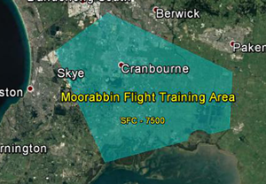
A designated training area has been established by the Civil Aviation Safety Authority for flight training. This exists to the south-east of the airport. Once pilots progress past the circuit training stage of their courses they will begin flying to and around the training area.

Click to enlarge the image, right, and use your browser “back” button to return to this page.

The training area is outside controlled airspace, therefore aircraft do not need a clearance from air traffic control to operate in the training area.

This area extends from around 13 kilometres south-east of the airport in an arc from Hampton Park to Carrum Downs then down to the Yaringa Yacht Marina on Western Port and then over to Koo Wee Rup and up to the south of Pakenham and to Hampton Park, making it a wedge shape. Inside the training area is a designated aerobatic area and a parachuting area on the southern edge.

The area is heavily used with some aircraft training outside the area in adjoining airspace.

The training area extends from surface level (“SFC”) up to 7500 feet and in some areas 8500 feet.

Aircraft departing Moorabbin for the training area will generally either remain over land until they pass Carrum, then track coastal or stay over land and track to the training area. Tracking back to the airport from the training area, the aircraft will either track coastal or track north over the Eumemmerring area to the airport.

Moorabbin Airport Flight Paths

The majority of aircraft using Moorabbin Airport fly under Visual Flight Rules (VFR). There are designated routes for VFR aircraft to ensure that VFR traffic remains separate from aircraft flying under Instrument Flight Rules (IFR). It is not mandatory that VFR aircraft fly these routes, but many do, especially as they approach or depart airports.

These routes are outside controlled airspace (“OCTA”), that is, aircraft are not being directed by air traffic control. Whenever they fly outside controlled airspace, pilots are following the rules of the air. More information about airspace is found here.

VFR routes include defined entry and exit points to and from controlled airspace. These are landmarks that are easily seen by the pilot from the air. These landmarks are highlighted in the images below, which also show the average percentage of arrivals or departures that use the route.

There is no minimum altitude for aircraft in the process of landing. Aircraft will generally descend on a glide slope of three degrees.

The altitude of aircraft after departure will depend on factors such as the type of aircraft and its weight, how heavily laden it is with fuel and passengers, and the atmospheric conditions at the time. All these factors affect an aircraft’s climb rate. There is no regulated minimum altitude for an aircraft in the process of taking off.

.

Arrival routes

The VFR arrival route from the north tracks via Kilmore at an altitude of not above 4500 feet. Before crossing the Hume Freeway aircraft must be at or below 3500 feet. At Sugarloaf Reservoir aircraft cannot be above 2500 feet before tracking to the Academy (an old monastery) at 1500 feet. Sandown Racecourse marks the boundary of the Moorabbin control zone.

The inbound route from the west starts at Bacchus Marsh where aircraft must be below 3500 feet. It then tracks to Laverton Bureau of Meteorology Tower while descending to 1500 feet. Aircraft track to Altona South river mouth from where they can track directly across the bay to Brighton if they are equipped to fly beyond gliding distance from land. If not, they join the VFR coastal route, tracking to Station Pier via Williamstown, and maintaining 1500 feet. From Brighton, aircraft track via Southland Shopping Centre to the start point for an approach to the active runway.

From the south aircraft track via Mornington Peninsula to Carrum at 1500 feet. They then fly to Mordialloc Pier before joining the approach to the active runway.

Inbound from the east aircraft will track via the former General Motors Holden complex at 1500 feet, and then Parkmore Shopping Centre and Sandown Racecourse

Departure routes

The departure route to the north tracks via Ringwood, Sugarloaf Reservoir and Kilmore Gap. If departing from Runway 31 Left aircraft must maintain runway heading until over the Kingston Centre.

Outbound to the south aircraft must remain overland until the Paterson River to avoid inbound traffic, and then may turn and follow the coast. If departing Runway 17 Right aircraft turn left to follow the coast when south of Woodland Golf Course.

The route to the north-west tracks via the coast. After departure aircraft will climb to 2500 feet and follow the route past Altona South and Laverton Bureau of Meteorology Tower.

Training Area

A designated training area has been established by the Civil Aviation Safety Authority for flight training. This exists to the south-east of the airport. Once pilots progress past the circuit training stage of their courses they will begin flying to and around the training area.

Click to enlarge the image, right, and use your browser “back” button to return to this page.

The training area is outside controlled airspace, therefore aircraft do not need a clearance from air traffic control to operate in the training area.

This area extends from around 13 kilometres south-east of the airport in an arc from Hampton Park to Carrum Downs then down to the Yaringa Yacht Marina on Western Port and then over to Koo Wee Rup and up to the south of Pakenham and to Hampton Park, making it a wedge shape. Inside the training area is a designated aerobatic area and a parachuting area on the southern edge.

The area is heavily used with some aircraft training outside the area in adjoining airspace.

The training area extends from surface level (“SFC”) up to 7500 feet and in some areas 8500 feet.

Aircraft departing Moorabbin for the training area will generally either remain over land until they pass Carrum, then track coastal or stay over land and track to the training area. Tracking back to the airport from the training area, the aircraft will either track coastal or track north over the Eumemmerring area to the airport.

Moorabbin Airport Circuit Training

Circuit training is the first stage of practical pilot training focused on take-offs and landings. It involves the pilot making approaches to the runway or helipad, touching down and then applying power to take off again. This is undertaken in accordance with Civil Aviation Safety Authority (CASA) Regulations which are consistent with international practices.

How circuits are conducted

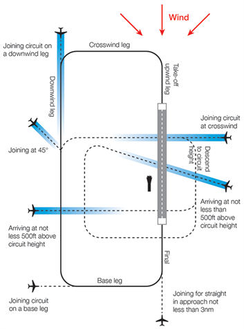
A training circuit consists of five legs – take-off, crosswind, downwind, base and final approach to the runway.

Aircraft take off into the wind, climb to 500 feet and then turn onto the crosswind leg. They continue to ascend to 1000 feet and turn onto the downwind leg. Having turned onto the base leg the descent commences. After turning onto the final leg and lining up with the runway the aircraft will touch down and take off again.
Helicopters circuit inside the fixed wing circuit at a lower altitude.

The majority of circuits are performed on the eastern side of the airport while arrivals and departures operate from the western side.

“Left-hand” circuits will be conducted when Runway 17 Left is being used, and “right-hand” circuits when Runway 35 Right is used. For left-hand circuits, the pilot turns left after take-off and flies anticlockwise. For right-hand circuit, the pilot turns right and flies in a clockwise direction.

A simplified representation of a left-hand circuit is shown at right. The take off and final stage of the circuit is flown into the wind, as this is the safest way for an aircraft to operate. The aircraft symbols and dotted lines indicate recommended ways for an aircraft to join the circuit pattern. Click the image to enlarge it, and use your browser “Back” button to return to this page.

Moorabbin Airport’s voluntary Fly Friendly Program asks tenants and airport users to keep circuits as tight as possible. However, because the student pilots performing circuits are so new to flying, this is not always achievable.

More information about circuit training is found here.

Animation of the Moorabbin circuit

The animated aircraft below and the static tracks shown in blue are created from actual tracks flown by aircraft in the circuit. This illustrates the degree of variation that will occur in the way student pilots fly circuits. The altitudes above mean sea level of the aircraft are also shown.

You can enlarge to full-screen by clicking the square-shaped button in the bottom right-hand corner of the player.

To replay the animation press the “Replay” button in the bottom left-hand corner of the player.


Effects of runway direction

Air traffic control will determine which runways are used at any given time depending on the direction of the wind – this is because aircraft must generally take off and land into the wind for safety reasons. Depending on which runway direction is in use, different suburbs will be affected by different legs of the circuit.

The Noise Complaints and Information Service tends to receive more complaints from suburbs under the crosswind and base legs of the circuit. This is the case at all airports where circuit training occurs. When the north-south runways are being used in a northerly direction (Runways 35 Left and Right), parts of Heatherton and Dingley Village will be affected by the crosswind leg and Braeside and Mordialloc will be affected by the base leg. The opposite is true when these runways are being used in a southerly direction (Runways 17 Left and Right).

Similarly, when the north-west – south-east runways are used in a northerly direction (Runways 31 Left and Right), Heatherton is affected by the crosswind leg and Dingley Village and Braeside by the base leg with the opposite effect when the runways are used in a southerly direction (Runways 13 Left and Right).


Circuit Training hours

Training during both day and night is important for developing pilot competencies, as is experience with using different types of navigational aids.

Circuit training times for Moorabbin Airport are:

Non-daylight saving periods:
Monday to Friday: 8:00am – 9:00pm
Weekends: 9:00am – 6:00pm or last light, whichever is sooner

Daylight saving periods:
Monday to Friday: 8:00am – 10:00pm
Weekends: 9:00am – 6:00pm or last light, whichever is sooner

Please note that these times above apply only to circuit training, and not to arriving and departing aircraft which may operate 24 hours a day. It is important to note that when aircraft are arriving outside control tower hours they are required to fly a circuit before landing for safety reasons. Therefore it may seem like aircraft are flying circuits outside hours when this is not the case.

There are only two lit runways, Runway 13 Left/35 Right and Runway 17 Left/31 Right. This means these runways must be used for night circuits. In turn, this means that all night circuits will take place to the east of the airport. Due to flying training courses running on different schedules, some nights will have multiple aircraft operating and other nights none at all.


Altitudes

Select a quarter to see charts showing a breakdown of which side of the airport circuits were conducted in that period. The breakdowns are shown as percentages rather than total counts. This is because the source radar data for Moorabbin Airport has gaps due to the radar being located at Melbourne Airport. As these gaps occur randomly throughout the day, the data, while incomplete, provides a representative picture of the distribution of circuits.