Moorabbin Airport Flight Paths
The majority of aircraft using Moorabbin Airport fly under Visual Flight Rules (VFR). There are designated routes for VFR aircraft to ensure that VFR traffic remains separate from aircraft flying under Instrument Flight Rules (IFR). It is not mandatory that VFR aircraft fly these routes, but many do, especially as they approach or depart airports.
These routes are outside controlled airspace (“OCTA”), that is, aircraft are not being directed by air traffic control. Whenever they fly outside controlled airspace, pilots are following the rules of the air. More information about airspace is found here.
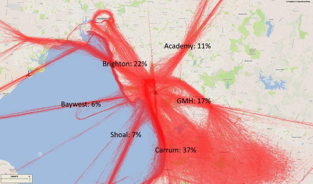
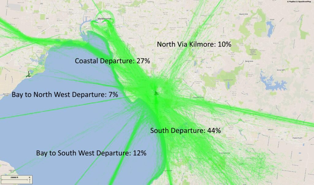
VFR routes include defined entry and exit points to and from controlled airspace. These are landmarks that are easily seen by the pilot from the air. These landmarks are highlighted in the images below, which also show the average percentage of arrivals or departures that use the route.
There is no minimum altitude for aircraft in the process of landing. Aircraft will generally descend on a glide slope of three degrees.
The altitude of aircraft after departure will depend on factors such as the type of aircraft and its weight, how heavily laden it is with fuel and passengers, and the atmospheric conditions at the time. All these factors affect an aircraft’s climb rate. There is no regulated minimum altitude for an aircraft in the process of taking off.
.
Arrival routes
The VFR arrival route from the north tracks via Kilmore at an altitude of not above 4500 feet. Before crossing the Hume Freeway aircraft must be at or below 3500 feet. At Sugarloaf Reservoir aircraft cannot be above 2500 feet before tracking to the Academy (an old monastery) at 1500 feet. Sandown Racecourse marks the boundary of the Moorabbin control zone.
The inbound route from the west starts at Bacchus Marsh where aircraft must be below 3500 feet. It then tracks to Laverton Bureau of Meteorology Tower while descending to 1500 feet. Aircraft track to Altona South river mouth from where they can track directly across the bay to Brighton if they are equipped to fly beyond gliding distance from land. If not, they join the VFR coastal route, tracking to Station Pier via Williamstown, and maintaining 1500 feet. From Brighton, aircraft track via Southland Shopping Centre to the start point for an approach to the active runway.
From the south aircraft track via Mornington Peninsula to Carrum at 1500 feet. They then fly to Mordialloc Pier before joining the approach to the active runway.
Inbound from the east aircraft will track via the former General Motors Holden complex at 1500 feet, and then Parkmore Shopping Centre and Sandown Racecourse
Departure routes
The departure route to the north tracks via Ringwood, Sugarloaf Reservoir and Kilmore Gap. If departing from Runway 31 Left aircraft must maintain runway heading until over the Kingston Centre.
Outbound to the south aircraft must remain overland until the Paterson River to avoid inbound traffic, and then may turn and follow the coast. If departing Runway 17 Right aircraft turn left to follow the coast when south of Woodland Golf Course.
The route to the north-west tracks via the coast. After departure aircraft will climb to 2500 feet and follow the route past Altona South and Laverton Bureau of Meteorology Tower.
Training Area
A designated training area has been established by the Civil Aviation Safety Authority for flight training. This exists to the south-east of the airport. Once pilots progress past the circuit training stage of their courses they will begin flying to and around the training area.
Click to enlarge the image, right, and use your browser “back” button to return to this page.
The training area is outside controlled airspace, therefore aircraft do not need a clearance from air traffic control to operate in the training area.
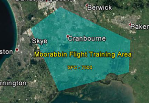
This area extends from around 13 kilometres south-east of the airport in an arc from Hampton Park to Carrum Downs then down to the Yaringa Yacht Marina on Western Port and then over to Koo Wee Rup and up to the south of Pakenham and to Hampton Park, making it a wedge shape. Inside the training area is a designated aerobatic area and a parachuting area on the southern edge.
The area is heavily used with some aircraft training outside the area in adjoining airspace.
The training area extends from surface level (“SFC”) up to 7500 feet and in some areas 8500 feet.
Aircraft departing Moorabbin for the training area will generally either remain over land until they pass Carrum, then track coastal or stay over land and track to the training area. Tracking back to the airport from the training area, the aircraft will either track coastal or track north over the Eumemmerring area to the airport.