Bankstown and Camden Airport – Training areas

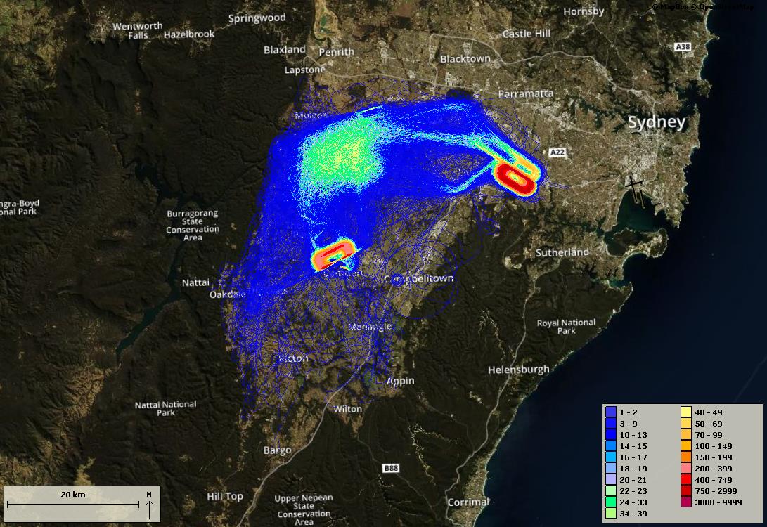
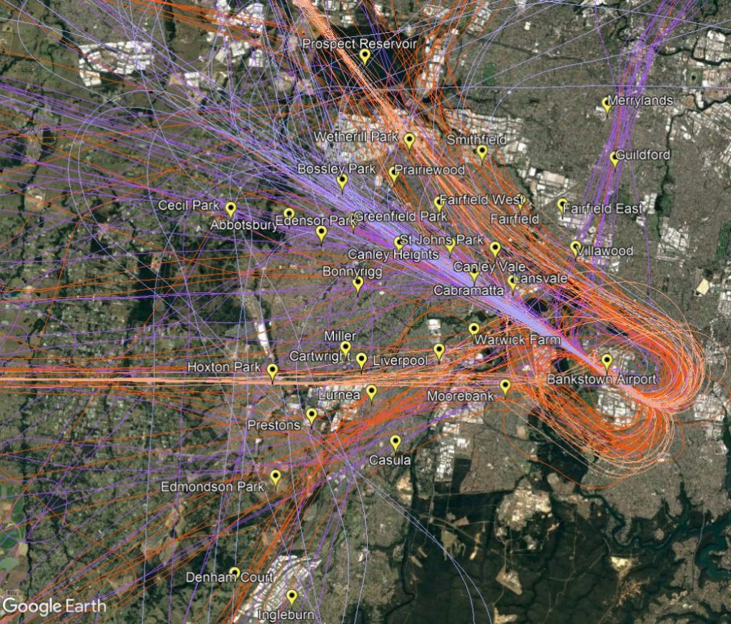
There are a number of designated flight training areas to the west and south-west of Bankstown Airport and surrounding Camden Airport. Once pilots progress past the initial circuit training stage of their learning they will begin flying to and around these training areas.

Training areas

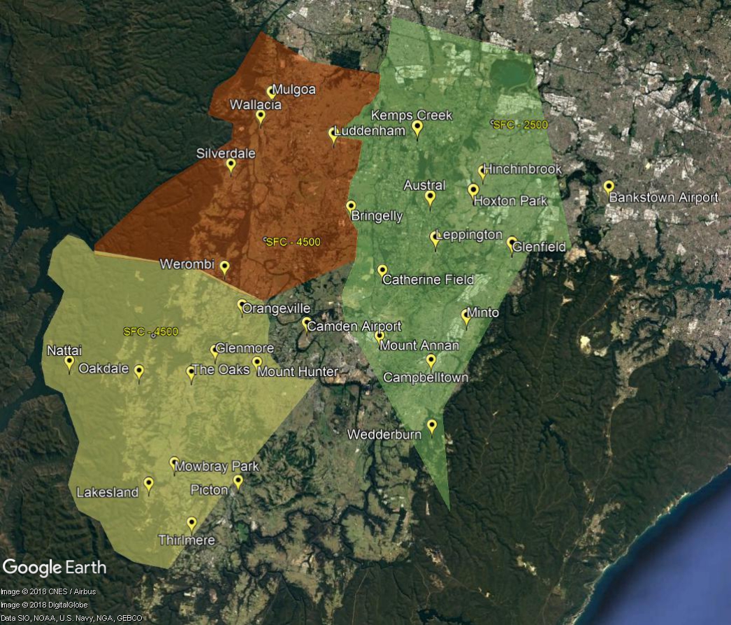
These areas extend from ground level to between 2,500 feet to 4,500 feet. The closer the training area is to Sydney Airport, the lower the upper limit will be to ensure that aircraft do not conflict with arrivals and departures using Sydney Airport.

In addition to pilot training, activities including model aircraft flights, ultralight aircraft flights, as well as aerobatic flights can occur. Parachute jumping generally occurs to the south of the training areas over the Wilton aerodrome area. Transiting aircraft may also track over the area.

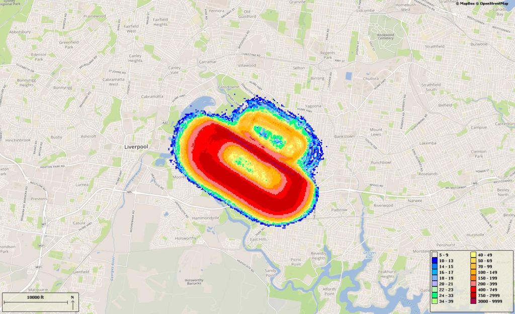
The training areas are outside controlled airspace. This means that aircraft are not being directed by air traffic control. The following image shows the density of aircraft using the training areas and flying between the training areas, Camden and Bankstown Airports over a typical three-month period.

The colour indicates the density – the hotter and deeper the colour, the greater the number of movements. The legend in the bottom right-hand corner indicates the number of movements per quarter depicted by each colour.

Track density

Bankstown Airport circuits

Circuit training is the first stage of practical pilot training, focused on take-offs and landings. It involves the pilot making approaches to the runway, touching down and then applying power to take-off again.

Circuit training is undertaken at most airports, particularly regional and general aviation aerodromes. How a circuit is flown and its location is determined by the Civil Aviation Safety Authority.

The animation below shows how a circuit is typically flown. it has been created using typical tracks which are shown in blue whilst an animated aircraft flies the circuit. The circuit will only be used by one aircraft at any given time.

The animation illustrates the degree of variation that will occur in the way pilots fly circuits. The altitudes above mean sea level of the aircraft are also shown. You can enlarge to full-screen by clicking the square-shaped button in the bottom right-hand corner of the player.

The following image shows the density of aircraft in the circuit over a the quarter. The colour indicates the density – the hotter and deeper the colour, the greater the number of movements.

Important information for residents near circuit training airports

Aircraft movement information in this portal may inaccurately count some low-level flights at Secondary airports.

Why is this so?

The aircraft movement data comes from the radar located close to the major airport which is used by air traffic control to manage aircraft within controlled airspace.  Low-level flights around secondary airports, such as circuit training flights, can be partially hidden from the radar’s line of sight by buildings and hills, potentially making counts inaccurate.

Learn more

Learn more about how radar coverage affects counting of low-level aircraft movements at secondary airports in our Help and Technical Information page, available in the resources section.

Bankstown Airport flight paths

Bankstown Airport was established in the 1940s and is a general aviation airport primarily used by general aviation aircraft.

The airport is a base for the NSW Police Air Wing, the NSW National Parks and Wildlife Service, the Royal Flying Doctor Service, NSW Forests, Greater Sydney Area Helicopter Medical Service, and the Aviation Studies program of the University of NSW. During the summer months large firefighting helicopters are also based at Bankstown Airport.

Bankstown Airport operates 24 hours a day but noise abatement procedures apply.

Flight paths

The majority of aircraft using Bankstown Airport fly on designated routes to ensure separation with other air traffic, including aircraft operating to and from Sydney Airport.

These routes are outside controlled airspace which means that aircraft using them are not being directed by air traffic control. When flying outside of controller airspace pilots are following the rules of the air. Our booklet, Guide to our Operations, explains more about different types of airspace.

The transition between uncontrolled and controlled airspace, such as the are around Bankstown airport, must happen at defined points to maintain safety. These points are often located at local landmarks so they are easily recognized by pilots from the air.

When operating around Bankstown airport it is important to note that:

  • For arriving and landing aircraft there is no minimum altitude limit although aircraft will typically descent to the airport on a glide slope.
  • For departing aircraft, there is no also no minimum altitude limit and the rate of climb will vary depending on a number of factors including the type of aircraft and its weight, how heavily laden it is with fuel and passengers, and the atmospheric conditions at the time.

The following image displays the typical flight paths into and out of Bankstown.

Bankstown Airport statistics

Use this interactive tool to explore Bankstown Airport statistics. Data is available from January 2017.

This report is best viewed in full screen mode.

The statistical breakdowns in the report are shown as percentages rather than total counts. This is because the source radar data for Bankstown Airport has gaps due to the location of the radar at Sydney Airport. As these gaps occur randomly throughout the day, the data, while incomplete, provides a representative picture of the weekly, hourly and day/night distribution of operations. You can read more about this on our Help and Technical Information page.