Learn about flight paths and aircraft movements in your area
Welcome to the Aircraft in Your Neighborhood Portal
Our goal is that you will learn more about the flight paths and aircraft movements in your area and be able to access the information and resources that explain how air traffic is managed.
First, please select your location using one of the following options, so that we can customize the information for your location.
We’ll remember your location so you don’t have to enter it every time you visit the site and we’ll keep this information confidential.
Please note, that this site works best on Chrome, Firefox and Edge.
* Mandatory - Select region first to view the map.
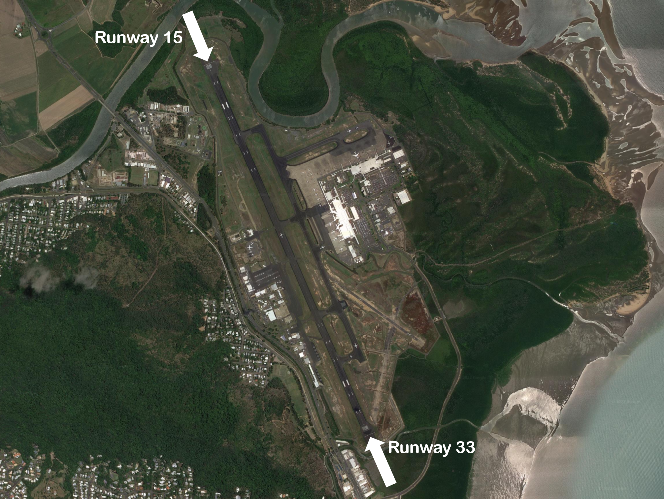
Cairns Airport currently has one operational runway: Runway 15/33. It is orientated north-south. The runway is 3196 metres long and has precision navigation aids at both ends enhancing the safe operation of aircraft landing from either the north or south.
The runway is referred to differently according to in which direction it is being used. For example it is known as Runway 33 when used in a northerly direction and Runway 15 when used in a southerly direction. Runway numbering reflects the runways’ orientation and correlates with degrees on a compass. Runway 33 is 330 degrees.
An Instrument Landing System operates for aircraft landing on Runway 15.
The following video explains how runways are named and used.
Runway selection and seasonal winds
Runway selection is based on wind direction, weather conditions, traffic volume and other factors. Aircraft primarily take-off and land into the wind for safety and performance reasons. Therefore, as the wind direction changes the runway in operation may also change depending on the strength of the wind.
This means that Cairns’ seasonal wind patterns affect usage of the runway directions. The prevailing wind year-round tends to be southerly which results in more use of Runway 15. Therefore, when the wind direction is northerly and Runway 33 is used, it can be more noticeable to affected residents because it occurs less frequently.
Noise abatement procedures
Noise abatement procedures are designed to help reduce the impact of aircraft noise on communities. While they are applied whenever it is possible to do so, their use is not mandatory and is subject to weather conditions and traffic requirements.
The Cairns Noise Abatement Procedures outline that the preferred runway for landing and take-off is Runway 15. Arriving aircraft will be directed to use routes that are clear of highly populated areas until they are seawards of the coastline or established on their final approach to land. Pilots are asked to delay flap deployment until as late as is operationally practicable when on final approach.
Between 10.00 pm and 7.00 am, circuit training by jet aircraft (and other aircraft exceeding 5700 kilograms maximum take-off weight) is not permitted.
Between 11.00 pm and 6.00 am, no aircraft is permitted to conduct engine run ups (unless associated with the normal preparation of flight) without Cairns Airport permission. Operators and pilots of jet aircraft are also requested to cooperate in limiting the use of reverse thrust when landing.
A designated training area exists to the north-west of the airport and to the west and north-west of the RAAF Edinburgh Base. Once pilots progress past the circuit training stage of their courses they will begin flying to and around the training area.
Click to enlarge the image, right, and use your browser “back” button to return to this page.
The training area is outside controlled airspace. It extends from St Kilda, which is approximately 10 kilometres west-north-west of the airport, to Long Plains, which is a further 45 kilometres to the north-west of St Kilda. The training area is to the west of this line and extends to 9 kilometres off the coast. It is ‘wedge-shaped’ because it is located in-between military restricted airspace to the west and north and the RAAF Edinburgh Base Control Zone to the east.
From the St Kilda area to just south of Middle Beach the training area exists between the surface (“SFC”) and 2500 feet. North to Long Plains the area extends between the surface and 4500 feet. These levels keep the aircraft below controlled airspace; therefore aircraft do not need a clearance from air traffic control to operate in the training area.
Aircraft wishing to track to the training area from Parafield Airport must remain south of the Bolivar strobe light and west of St Kilda to remain outside controlled airspace. The north- and southbound VFR routes (described above) transit the area.
Activities that may occur inside the training area include parachute operations and light aircraft movements at Lower Light aircraft landing area, as well as training flights by light aircraft in and around the area and aircraft transiting on the north and southbound VFR routes. There can be increased traffic volumes in the area due to use by flight training companies from Parafield Airport and because all aircraft are confined to a relatively small area due to the surrounding military airspace including RAAF Base Edinburgh.
Jandakot Airport has three runways. A set of parallel runways, known as Runways 06 Left/24 Right and Runways 06 Right/24 Left are aligned approximately north-east to south-west. These runways are used for approximately 85 per cent of all movements. The alternate runway, Runway 12/30, is aligned approximately north-west to south-east.
Each runway is referred to differently according to in which direction it is being used. For example, the parallel runways are referred to as Runway 06 Left and Right when used in a north-easterly direction and Runway 24 Left and Right when used in a south-westerly direction.
Runway numbering reflects the runways’ orientation and correlates with degrees on a compass. Runway 06 is 60 degrees magnetic.
The following video explains how runways are named and used.
Runway selection and seasonal winds
Runway selection is based on wind direction, weather conditions, traffic volume and other factors. See the Runway Selection page for more details. Aircraft primarily take-off and land into the wind for safety and performance reasons. Therefore, as the wind direction changes the runway in operation may also change depending on the strength of the wind.
This means that Perth’s seasonal wind patterns affect usage of the different runway directions. For example, Runways 06 Left and Right tend to be used more often in the cooler months when there are frequent winds with a northerly component. Runways 24 Left and Right tend to be used more frequently in the warmer months when the predominant wind direction tends to be southerly.
Outside of Tower operating hours the pilot must determine the runway to be used based on the wind direction.
Noise abatement procedures
Noise abatement procedures are designed to help reduce the impact of aircraft noise on communities. While they are applied whenever it is possible to do so, their use is not mandatory and is subject to weather conditions and traffic requirements.
The preferred runways for circuit training are Runways 06 Right and 24 Left. This means that most of the aircraft undertaking circuit training operate to the south-east of the airport. There are also set hours for circuit training.
Runways 06 Left and 24 Right are the preferred runways for other arrivals and departures.
There are voluntary ‘Fly Neighbourly Agreements’ between airport management and aircraft operators. These are intended to minimise the impact of aircraft noise on the surrounding community. More information is available on the Jandakot Airport website.
The principles of these Fly Neighbourly Agreements are, whilst maintaining safety of operations, to:
climb as soon as possible
maintain height
reduce engine revs as soon as possible
follow designated flight paths
avoid residential areas where possible
not fly wide circuits unless required by air traffic control
The illustration below shows how jet and non-jet (turbo-prop) aircraft typically operate at Melbourne Airport on the published instrument arrival and departure flight paths.
The animation is indicative only and provided for information purposes, on occasion flights may leave these general areas.
The illustration below shows how jet and non-jet (turbo-prop) aircraft typically operate at Adelaide Airport on the published instrument arrival and departure flight paths.
The animation is indicative only and provided for information purposes, on occasions flights may leave these general areas from time-to-time.
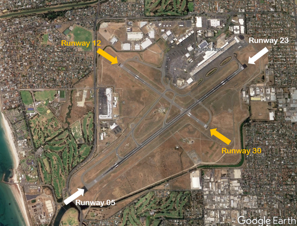
The main runway at Adelaide Airport, Runway 05/23 is 3 kilometres long and is orientated south-west to north-east. There is a smaller 1.6 kilometre cross runway, Runway 12/30, which is orientated north-west to south-east. The cross runway is primarily used by propeller aircraft.
Each runway is referred to differently according to in which direction it is being used. For example the main runway is known as Runway 05 when used in a north-easterly direction and 23 when used in a south-westerly direction. Runway numbering reflects the runways’ orientation and correlates with degrees on a compass. Runway 23 is 230 degrees.
The following video explains how runways are named and used.
Runway selection and seasonal winds
Runway selection is based on wind direction, weather conditions, traffic volume and other factors. Aircraft primarily take-off and land into the wind for safety and performance reasons. Therefore, as the wind direction changes the runway in operation may also change depending on the strength of the wind.
This means that Adelaide’s seasonal wind patterns affect usage of the different runway directions. The prevailing wind is southerly for most of the year, meaning that Runway 23 is used the most frequently. During the cooler months Runway 05 typically receives more use than at other times of the year because there tends to be more northerly winds.
Noise abatement procedures
Noise abatement procedures are designed to help reduce the impact of aircraft noise on communities. While they are applied whenever it is possible to do so, their use is not mandatory and is subject to weather conditions and traffic requirements.
In Adelaide the noise abatement procedures set out the preferred runway configuration for use during specific periods of the day. Between 6 am and 11 pm the most preferred runway is Runway 23 (arrivals over the suburbs and departures over the water), followed by Runway 05 as a second preference. If Runway 23/05 is not available, the preferred runway is Runway 30 and the second preference is Runway 12.
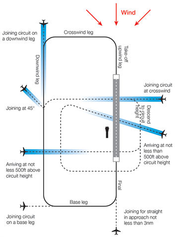
Circuit training is the first stage of practical pilot training focused on take-offs and landings. It involves the pilot making approaches to the runway or helipad, touching down and then applying power to take off again. This is undertaken in accordance with Civil Aviation Safety Authority (CASA) Regulations which are consistent with international practices.
How circuits are conducted
A training circuit consists of five legs – take-off, crosswind, downwind, base and final approach to the runway.
Aircraft take off into the wind, climb to 500 feet and then turn onto the crosswind leg. They continue to ascend to 1000 feet and turn onto the downwind leg. Having turned onto the base leg the descent commences. After turning onto the final leg and lining up with the runway the aircraft will touch down and take off again.
Helicopters circuit inside the fixed wing circuit at a lower altitude.
The majority of circuits are performed on the eastern side of the airport while arrivals and departures operate from the western side.
“Left-hand” circuits will be conducted when Runway 17 Left is being used, and “right-hand” circuits when Runway 35 Right is used. For left-hand circuits, the pilot turns left after take-off and flies anticlockwise. For right-hand circuit, the pilot turns right and flies in a clockwise direction.
A simplified representation of a left-hand circuit is shown at right. The take off and final stage of the circuit is flown into the wind, as this is the safest way for an aircraft to operate. The aircraft symbols and dotted lines indicate recommended ways for an aircraft to join the circuit pattern. Click the image to enlarge it, and use your browser “Back” button to return to this page.
Moorabbin Airport’s voluntary Fly Friendly Program asks tenants and airport users to keep circuits as tight as possible. However, because the student pilots performing circuits are so new to flying, this is not always achievable.
More information about circuit training is found here.
Animation of the Moorabbin circuit
The animated aircraft below and the static tracks shown in blue are created from actual tracks flown by aircraft in the circuit. This illustrates the degree of variation that will occur in the way student pilots fly circuits. The altitudes above mean sea level of the aircraft are also shown.
You can enlarge to full-screen by clicking the square-shaped button in the bottom right-hand corner of the player.
To replay the animation press the “Replay” button in the bottom left-hand corner of the player.
Effects of runway direction
Air traffic control will determine which runways are used at any given time depending on the direction of the wind – this is because aircraft must generally take off and land into the wind for safety reasons. Depending on which runway direction is in use, different suburbs will be affected by different legs of the circuit.
The Noise Complaints and Information Service tends to receive more complaints from suburbs under the crosswind and base legs of the circuit. This is the case at all airports where circuit training occurs. When the north-south runways are being used in a northerly direction (Runways 35 Left and Right), parts of Heatherton and Dingley Village will be affected by the crosswind leg and Braeside and Mordialloc will be affected by the base leg. The opposite is true when these runways are being used in a southerly direction (Runways 17 Left and Right).
Similarly, when the north-west – south-east runways are used in a northerly direction (Runways 31 Left and Right), Heatherton is affected by the crosswind leg and Dingley Village and Braeside by the base leg with the opposite effect when the runways are used in a southerly direction (Runways 13 Left and Right).
Circuit Training hours
Training during both day and night is important for developing pilot competencies, as is experience with using different types of navigational aids.
Circuit training times for Moorabbin Airport are:
Non-daylight saving periods: Monday to Friday: 8:00am – 9:00pm Weekends: 9:00am – 6:00pm or last light, whichever is sooner
Daylight saving periods: Monday to Friday: 8:00am – 10:00pm Weekends: 9:00am – 6:00pm or last light, whichever is sooner
Please note that these times above apply only to circuit training, and not to arriving and departing aircraft which may operate 24 hours a day. It is important to note that when aircraft are arriving outside control tower hours they are required to fly a circuit before landing for safety reasons. Therefore it may seem like aircraft are flying circuits outside hours when this is not the case.
There are only two lit runways, Runway 13 Left/35 Right and Runway 17 Left/31 Right. This means these runways must be used for night circuits. In turn, this means that all night circuits will take place to the east of the airport. Due to flying training courses running on different schedules, some nights will have multiple aircraft operating and other nights none at all.
Altitudes
Select a quarter to see charts showing a breakdown of which side of the airport circuits were conducted in that period. The breakdowns are shown as percentages rather than total counts. This is because the source radar data for Moorabbin Airport has gaps due to the radar being located at Melbourne Airport. As these gaps occur randomly throughout the day, the data, while incomplete, provides a representative picture of the distribution of circuits.
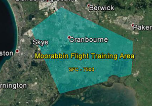
A designated training area has been established by the Civil Aviation Safety Authority for flight training. This exists to the south-east of the airport. Once pilots progress past the circuit training stage of their courses they will begin flying to and around the training area.
Click to enlarge the image, right, and use your browser “back” button to return to this page.
The training area is outside controlled airspace, therefore aircraft do not need a clearance from air traffic control to operate in the training area.
This area extends from around 13 kilometres south-east of the airport in an arc from Hampton Park to Carrum Downs then down to the Yaringa Yacht Marina on Western Port and then over to Koo Wee Rup and up to the south of Pakenham and to Hampton Park, making it a wedge shape. Inside the training area is a designated aerobatic area and a parachuting area on the southern edge.
The area is heavily used with some aircraft training outside the area in adjoining airspace.
The training area extends from surface level (“SFC”) up to 7500 feet and in some areas 8500 feet.
Aircraft departing Moorabbin for the training area will generally either remain over land until they pass Carrum, then track coastal or stay over land and track to the training area. Tracking back to the airport from the training area, the aircraft will either track coastal or track north over the Eumemmerring area to the airport.
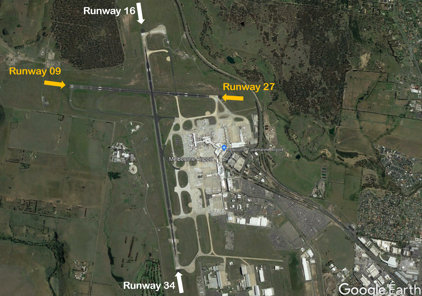
Melbourne Airport has two runways; the main runway, Runway 16/34 (3.7 km long) is orientated north-south and the smaller cross runway, Runway 09/27 (2.3km) is orientated east-west.
The main runway is known as Runway 34 when used in a northerly direction and Runway 16 when used in a southerly direction. Runway numbering reflects the runways’ orientation and correlates with degrees on a compass. Runway 34 is 340 degrees.
The following video explains how runways are named and used.
An Instrument Landing System operates for aircraft landing on Runways 16 and 27, and non-precision approaches are available to all runways.
Runway selection and seasonal winds
Runway selection is based on wind direction, weather conditions, traffic volume and other factors. Aircraft primarily take-off and land into the wind for safety and performance reasons. Therefore, as the wind direction changes the runway in operation may also change depending on the strength of the wind.
This means that Melbourne’s seasonal wind patterns affect usage of the different runway directions. Specifically, Runway 16 tends to be used more frequently in the warmer months due to southerly winds whereas Runway 34 tends to be used more frequently in the cooler months when the predominant wind direction tends to be northerly. The pattern of use of Runway 27 tends to be less clear-cut as it can generally be used with either a northerly or southerly wind, provided the crosswind does not exceed the maximum allowed speed of 20 knots, including gusts.
Runways may be used in combination. For example, Runway 27 may be used for departures while Runways 27 and 34 are being used in combination for arrivals.
Noise abatement procedures
Noise abatement procedures are designed to help reduce the impact of aircraft noise on communities. While they are applied whenever it is possible to do so, their use is not mandatory and is subject to weather conditions and traffic requirements. Apart from weather, other operational factors can also necessitate using a particular runway e.g. some large heavy aircraft and long haul flights require the length of the north-south runway to take off or land safely.
The Melbourne Airport Noise Abatement Procedures (NAP) prioritise landings and take-offs over less populated areas to the north and west of the airport whenever possible. The NAP distributes the use of flight paths via the nominated runways to lessen noise intensity over any single area.
The NAP outlines that between 6.00 am and 11.00 pm, when there is not heavy traffic, Runways 16 and 27 are equally preferred for landing. Runway 27 used in combination with Runway 34, and Runway 27 used alone, are equally preferred for departures.
During busy periods between 6.00 am and 11.00 pm, Runways 27 and 34 used in combination and Runways 34 and 09 used in combination are equally preferred.
At night, between 11.00 pm and 6.00 am, the preferred runway for arrivals is Runway 16 and for departures is Runway 27.
Melbourne Airport uses the high capacity landing mode, LAHSO (Land and Hold Short Operations) on Runway 34 during peak periods when wind conditions allow. It is used to increase airport capacity during peak arrival periods when significant airborne delays would otherwise occur. In this mode, aircraft land on runway 34 and exit the runway before the intersection with the east-west runway 09/27, so both runways can be used at the same time with minimal disruption. Pilots may accept a LAHSO clearance provided that the pilot-in-command is approved to use the procedure and has determined the aircraft can safely land and stop within the available landing distance.
When high arrivals demand requires the use of LAHSO, or when wind conditions mean that only one runway can be used due to strong crosswinds, the priority runways will change accordingly.
Melbourne Airport third runway
In September 2024, the federal government approved the Major Development Plan (MDP) for the construction of the third runway at Melbourne Airport.
Melbourne Airport conducted public exhibition of the MDP from February to May 2022, giving the community an opportunity to provide feedback and utilise an interactive noise tool to explore future aircraft tracks. The proposal included detailed planning documents and considered the project’s impact on the community.
The MDP approval is subject to certain conditions on Melbourne Airport including:
design and implementation of a Noise Sharing and Airspace Concept Plan that prioritises sharing of aircraft noise between affected areas
maintaining sufficient capacity on the existing east-west runway to support noise sharing
implementation of a noise amelioration program to communities most impacted
conducting a community health study into the impacts of noise before and after the establishment of the third runway
We expect that the operation of the third runway will result in aircraft noise decreasing in some areas and increasing in others. Further community engagement will be undertaken by both Airservices Australia and Melbourne Airport throughout the flight path design process.
For more information on the third runway and upcoming consultation opportunities, please visit the Melbourne Airport website.
The majority of aircraft using Moorabbin Airport fly under Visual Flight Rules (VFR). There are designated routes for VFR aircraft to ensure that VFR traffic remains separate from aircraft flying under Instrument Flight Rules (IFR). It is not mandatory that VFR aircraft fly these routes, but many do, especially as they approach or depart airports.
These routes are outside controlled airspace (“OCTA”), that is, aircraft are not being directed by air traffic control. Whenever they fly outside controlled airspace, pilots are following the rules of the air. More information about airspace is found here.
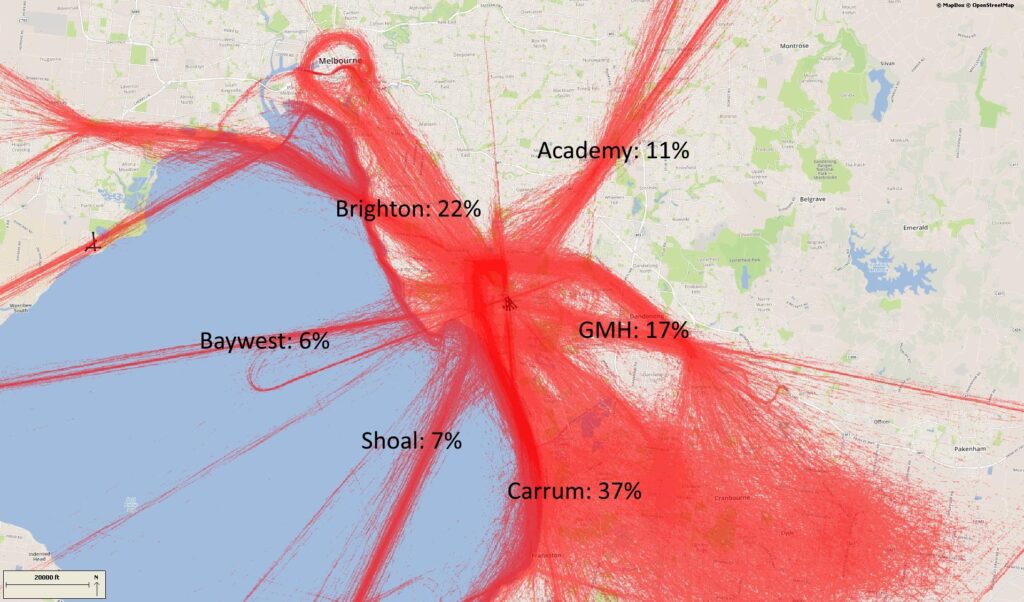
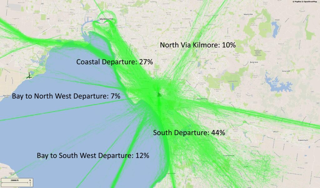
VFR routes include defined entry and exit points to and from controlled airspace. These are landmarks that are easily seen by the pilot from the air. These landmarks are highlighted in the images below, which also show the average percentage of arrivals or departures that use the route.
There is no minimum altitude for aircraft in the process of landing. Aircraft will generally descend on a glide slope of three degrees.
The altitude of aircraft after departure will depend on factors such as the type of aircraft and its weight, how heavily laden it is with fuel and passengers, and the atmospheric conditions at the time. All these factors affect an aircraft’s climb rate. There is no regulated minimum altitude for an aircraft in the process of taking off.
.
Arrival routes
The VFR arrival route from the north tracks via Kilmore at an altitude of not above 4500 feet. Before crossing the Hume Freeway aircraft must be at or below 3500 feet. At Sugarloaf Reservoir aircraft cannot be above 2500 feet before tracking to the Academy (an old monastery) at 1500 feet. Sandown Racecourse marks the boundary of the Moorabbin control zone.
The inbound route from the west starts at Bacchus Marsh where aircraft must be below 3500 feet. It then tracks to Laverton Bureau of Meteorology Tower while descending to 1500 feet. Aircraft track to Altona South river mouth from where they can track directly across the bay to Brighton if they are equipped to fly beyond gliding distance from land. If not, they join the VFR coastal route, tracking to Station Pier via Williamstown, and maintaining 1500 feet. From Brighton, aircraft track via Southland Shopping Centre to the start point for an approach to the active runway.
From the south aircraft track via Mornington Peninsula to Carrum at 1500 feet. They then fly to Mordialloc Pier before joining the approach to the active runway.
Inbound from the east aircraft will track via the former General Motors Holden complex at 1500 feet, and then Parkmore Shopping Centre and Sandown Racecourse
Departure routes
The departure route to the north tracks via Ringwood, Sugarloaf Reservoir and Kilmore Gap. If departing from Runway 31 Left aircraft must maintain runway heading until over the Kingston Centre.
Outbound to the south aircraft must remain overland until the Paterson River to avoid inbound traffic, and then may turn and follow the coast. If departing Runway 17 Right aircraft turn left to follow the coast when south of Woodland Golf Course.
The route to the north-west tracks via the coast. After departure aircraft will climb to 2500 feet and follow the route past Altona South and Laverton Bureau of Meteorology Tower.
Training Area
A designated training area has been established by the Civil Aviation Safety Authority for flight training. This exists to the south-east of the airport. Once pilots progress past the circuit training stage of their courses they will begin flying to and around the training area.
Click to enlarge the image, right, and use your browser “back” button to return to this page.
The training area is outside controlled airspace, therefore aircraft do not need a clearance from air traffic control to operate in the training area.
This area extends from around 13 kilometres south-east of the airport in an arc from Hampton Park to Carrum Downs then down to the Yaringa Yacht Marina on Western Port and then over to Koo Wee Rup and up to the south of Pakenham and to Hampton Park, making it a wedge shape. Inside the training area is a designated aerobatic area and a parachuting area on the southern edge.
The area is heavily used with some aircraft training outside the area in adjoining airspace.
The training area extends from surface level (“SFC”) up to 7500 feet and in some areas 8500 feet.
Aircraft departing Moorabbin for the training area will generally either remain over land until they pass Carrum, then track coastal or stay over land and track to the training area. Tracking back to the airport from the training area, the aircraft will either track coastal or track north over the Eumemmerring area to the airport.