How seasonal variation affects your area

Aircraft usually take-off and land into the wind for safety and performance reasons. As the wind direction changes, the runway in operation and the flight paths being used may also change.

This means that Hobart’s seasonal wind patterns affect usage of the different runway directions.

Summer

During summer, when afternoon sea-breezes are common, the wind varies so both Runway 12 and Runway 30 are used.

Runway 30 is mostly used in the morning (8-9am) and evening (8-9pm) and Runway 12 is mostly used during the day (10am-5pm).

The flight paths in use change depending on the runway being used.

Runway 12 Typical Usage, Arrivals (Blue), Departures (Green)

When Runway 12 is used, aircraft depart to the south before turning north and crossing the coast near Connellys Marsh (jets) or Dodges Ferry/Carlton (non-jets). Aircraft arrive from the north using two approach paths (depending on the technology available on-board the aircraft) near Campania or Bagdad.

Runway 30 Typical Usage, Arrivals (Blue), Departures (Green)

When Runway 30 is used, aircraft depart to the north before turning near Bagdad (jets) or Richmond (non-jets). Aircraft arrive from the south using two approach paths (depending on the technology available on-board the aircraft), crossing the coast near Carlton/Primrose Sands or Connellys Marsh.

Most of the year

The prevailing wind is north-westerly for most of the year (approximately 75% of the year), meaning that Runway 30 is used most frequently.

The flight paths in use are most often those for Runway 30.

Runway 30 Typical Usage, Arrivals (Blue), Departures (Green)

When Runway 30 is used, aircraft depart to the north before turning near Bagdad (jets) or Richmond (non-jets). Aircraft arrive from the south using two approach paths (depending on the technology available on-board the aircraft), crossing the coast near Carlton/Primrose Sands or Connellys Marsh.


Learn more about how aircraft arrive to Hobart Airport on our When is each flight path used? page.

Note: All tracks have been displayed. Track colours have been adjusted to show track density. Where aircraft are more concentrated the colour will appear darker.

Hobart Airport Runway

Hobart Airport has one 2.7 kilometre long runway (aligned north-west/south-east) that operates in both directions, depending on the wind at the time of take-off or landing.

The following video explains how runways are named and used.

The runway at Hobart Airport is called Runway 12/30.

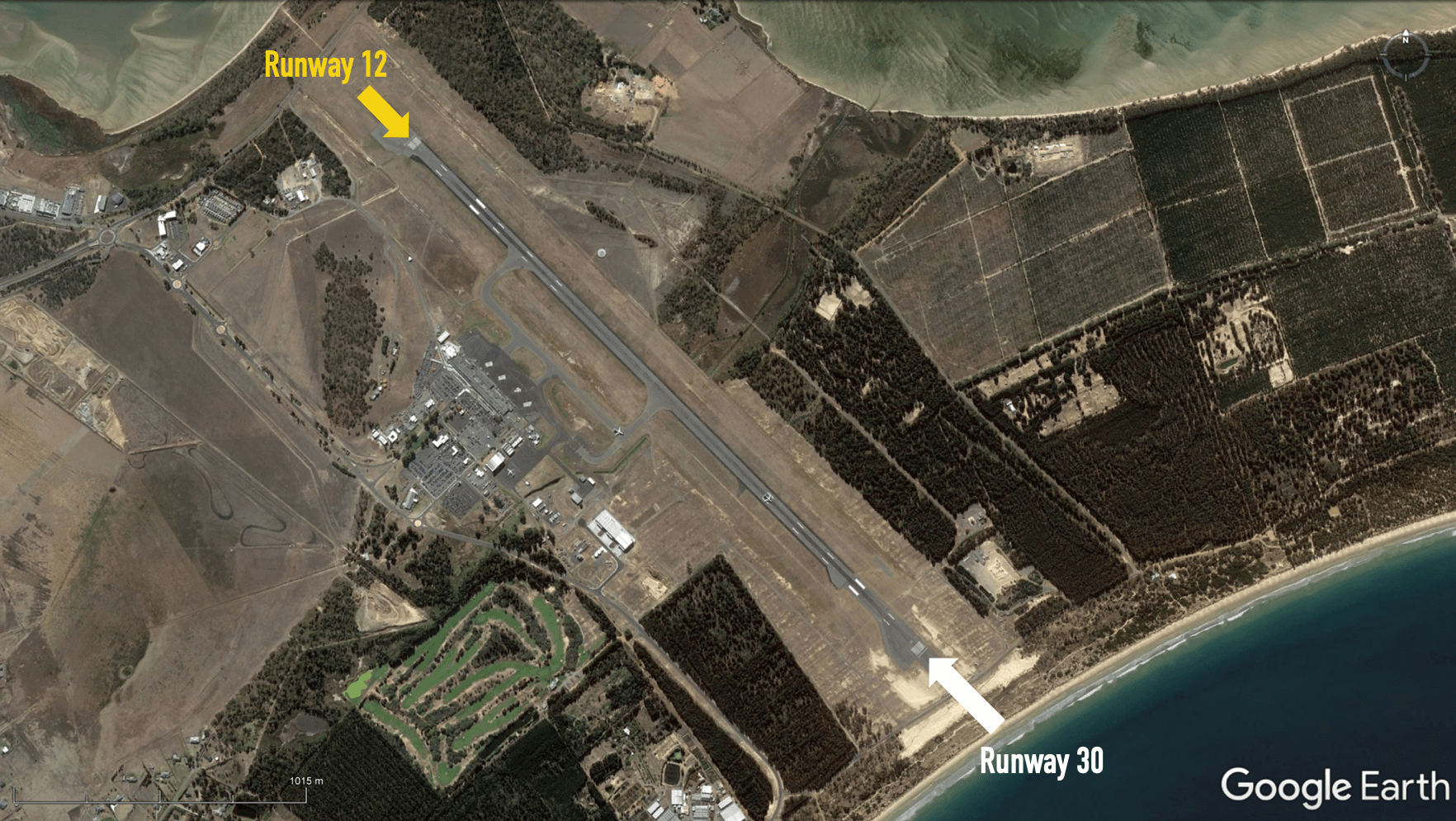
Runway numbering reflects the runways’ orientation and correlates with degrees on a compass. Runway 30 is 300 degrees while Runway 12 is at 120 degrees.

Operations in a south-easterly direction use Runway 12, and operations in a north-westerly direction use Runway 30.

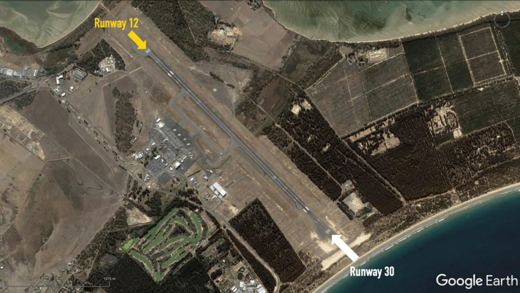
The image below shows the runway at Hobart, with:

  • The yellow arrow pointing to Runway 12
  • The white arrow pointing to Runway 30.

To learn more about the flight paths at Hobart Airport, take a look at our Hobart Airport Flight Paths page.

Hobart Airport noise abatement

Every major airport has Noise Abatement Procedures (NAPs), which are procedures designed to reduce the impact of aircraft noise on the community. There are some limitations to the use of NAPs and they may not be used if they generate delay and congestion, as this can cause noise and emission impacts. Air traffic control or pilots may not be able to use them in certain situations, for example weather conditions or operational requirements. 

At Hobart, during tower hours (between 5:50am and 10:10pm) NAPs preference instrument approaches and departures for large aircraft (e.g. jets).

The VHF omnidirectional radio (VOR) is the least preferred instrument option and may only be used for flight training for small aircraft (under 5700 kilograms) or for operational reasons when no alternative approach exists.

Hobart Airport community aviation consultation group

Federally-leased airports (excluding Mt. Isa and Tennant Creek) have established Community Aviation Consultation Groups (CACGs), which provide an effective avenue for local community engagement on airport planning and operations, including aircraft noise. The Department for Infrastructure, Transport, Regional Development and Communications provides guidelines for CACGs.

Non federally-leased airports may also choose to establish CACGs or community forums.

CACG membership depends on the characteristics of the airport and any local issues of community concern however, generally includes:

  • airport management
  • aircraft operators
  • community organisations or representatives
  • representatives from state, territory or local government bodies
  • local tourism and business groups.

Airservices does not formally belong to CACGs, but is invited to attend to provide relevant information and assist in discussions. We engage with CACGs on flight path and airspace changes, as well as technical reviews, such as noise monitoring and noise abatement procedures.

Find out more information on the Hobart Airport Community Aviation Consultation Group webpage.

How many aircraft fly near me?

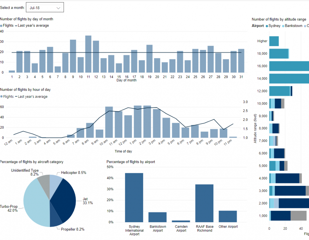
This tool shows the number of flights each day over your area in the selected month compared to the average for last year.  The bottom axis shows the day of the month. Use the drop-down menu to change the selected month to see how movements have varied. Hover over each day to see flight numbers.

*Please note due to technical issues between 19 June and 22 June 2024, flight data may not be accurately displayed. Our supplier is working to resolve the issue. We apologise for any inconvenience this may cause.

How frequent are flights in my area?

There are a number of factors that influence the frequency of flights.

Firstly, the number and frequency of flights will vary on a daily, weekly and yearly basis due to differences in airline schedules. The airlines schedule flights in response to consumer demand. This is particularly the case around Christmas, Easter, school holidays and Lunar New Year.

Secondly, the runway in use at any given time will also vary, largely due to the wind conditions. Each runway has its own set of flight paths, and each flight path will affect different areas. As the runway in use changes, the flight paths change, and so too do the areas affected by aircraft movements.

This chart shows the total number of flights each hour over the month, compared to the average for last year. Change the selected month to see how it has varied.

*Please note due to technical issues between 19 June and 22 June 2024, flight data may not be accurately displayed. Our supplier is working to resolve the issue. We apologise for any inconvenience this may cause.

How high are aircraft near me?

The altitudes of aircraft over your area can vary according to:

  • the airport the flight is coming from or going to
  • whether the aircraft is arriving, departing or in level flight
  • the specific requirements of the flight path
  • the need for air traffic control to maintain vertical separation between aircraft.

Find out more on our What are the rules about altitudes? page.

*Please note due to technical issues between 19 June and 22 June 2024, flight data may not be accurately displayed. Our supplier is working to resolve the issue. We apologise for any inconvenience this may cause.

Explore detailed data for your area

Use this interactive tool to explore detailed data for your area in the month of your choice.

This report is best viewed in full screen mode.

*Please note due to technical issues between 19 June and 22 June 2024, flight data may not be accurately displayed. Our supplier is working to resolve the issue. We apologise for any inconvenience this may cause.

Hobart Airport Flight Paths

Hobart Airport has a number of flight paths from its runway.

To learn more about the runway at Hobart Airport, take a look at our Hobart Airport Runway page.
The illustration below shows how jet and non-jet (turbo-prop) aircraft typically operate at Hobart Airport on the published instrument arrival and departure flight paths.

The animation is indicative only and provided for information purposes, on occasions flights may leave these general areas from time-to-time.

When is each flight path used?

Air traffic control manage the traffic to each runway at an airport using a range of operations which can include clearing aircraft to use published flight paths, issuing visual approaches or vectoring for separation and sequencing. As the runway in use changes, the types of operations in use will also change, and so different suburbs and areas are affected by aircraft movements.

Flight paths do not operate in isolation. They are part of an interconnected network. Flight paths need to accommodate aircraft operating constraints, provide terrain clearance and fit into the overall airspace design.

Flight paths at Hobart Airport are designed as standardised tracks that segregate arriving aircraft from departing aircraft.

Arrivals

Jet arrivals into Hobart Airport are generally aligned with the runway approximately 10 kilometres from the runway. From this point, they fly towards the runway in a straight line. This means suburbs and towns in line with the runway are overflown by arriving aircraft. Other suburbs and towns may be overflown by aircraft travelling to join the final approach to align with the runway.

There are two approach paths for each end of the runway, which are used depending on the technology available on-board arriving aircraft. Aircraft can either join the final approach path closer to the airport or, if they do not have the required technology, they can join it approximately 15-18 kilometres from the runway.

The altitude the aircraft will be at when it begins its final approach will depend on the remaining distance of flight to the runway. There is a regulated minimum altitude for aircraft at all stages of arrival that is determined by the height of terrain in the vicinity of the aircraft, however aircraft are usually well above this minimum altitude. Aircraft will generally descend on a glide slope of three degrees.

Departures

Departure flight paths allow aircraft to maintain the runway heading for a short time until they are stabilised in flight, before heading to their destinations. Departure paths also take into consideration any arrival paths or other departure paths that may need to be crossed.

There are separate departure paths for jets and non-jets at Hobart Airport. Jet departures continue straight ahead in their take-off direction for at least 13km before turning. Non-jets are turned off towards their headings sooner after departure. The purpose of non-jets turning sooner aims to make separation and traffic management simpler for air traffic control and improve airport efficiency.

The altitude of aircraft after departure depends on factors, including wind direction and speed, temperature, air pressure, aircraft type and aircraft weight (this can vary depending on passenger numbers and fuel load). All these factors affect an aircraft’s climb rate. There are regulated minimum altitudes (based on terrain heights in the vicinity of flight paths) for aircraft departing a runway, however performance of modern aircraft usually result in aircraft being much higher than minimum regulated altitudes. Aircraft taking off generally climb at a higher gradient than aircraft landing. Minimum altitudes are governed by international standards.


Learn more about how the runway is used on our Hobart Airport Runway page.