Learn about flight paths and aircraft movements in your area
Welcome to the Aircraft in Your Neighborhood Portal
Our goal is that you will learn more about the flight paths and aircraft movements in your area and be able to access the information and resources that explain how air traffic is managed.
First, please select your location using one of the following options, so that we can customize the information for your location.
We’ll remember your location so you don’t have to enter it every time you visit the site and we’ll keep this information confidential.
Please note, that this site works best on Chrome, Firefox and Edge.
* Mandatory - Select region first to view the map.
* Mandatory - Input correct address
Please enter region / valid address.
Category: How much variation should I expect in my area
During non-daylight saving periods you may notice some aircraft arriving in the early morning between 5.00am and 6.00am.
While the curfew ends at 6.00am, under the curfew regulations the Department of Infrastructure, Transport, Cities and Regional Development may permit a limited number of passenger flights to land between 5.00am and 6.00am during non-daylight-saving periods. When daylight saving is in place these flights arrive after the curfew ends at 6.00am, but when clocks are turned back at the end of daylight saving they arrive an hour earlier. These flights generally originate from ports where curfews prevent them leaving later.
These early morning flights are required to land from the south, over the water. However they may fly over land as they travel to cross the coast and join the final approach.
An arrival burst of long-haul international flights tends to occur just after the curfew ends at 6am.
Heavy jets, especially those flying long-haul routes, require the use of the westernmost parallel runway for landing, (Runway 16 Right), because it is the longest runway. The extra length is needed for a safe landing. For this reason residents in suburbs around the flight path to this runway are likely to notice increased movements in the hour immediately after the curfew.
A departure burst of long-haul international flights tends to occur in the last two hours before the Sydney Airport curfew begins.
Heavy jets, especially those flying long-haul routes, require the use of the westernmost parallel runway (Runway 34 Left) because it is the longest runway. The extra length is needed for a safe take-off. For this reason residents in suburbs under flight paths from this runway are likely to notice increased movements in the hour before the curfew.
You may notice that these heavily laden jets tend to climb more slowly than lighter aircraft.
Aircraft usually take-off and land into the wind for safety and performance reasons. As the wind direction changes, the runway in operation and the flight paths being used may also change.
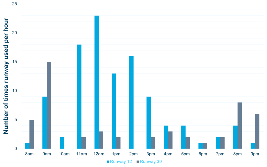
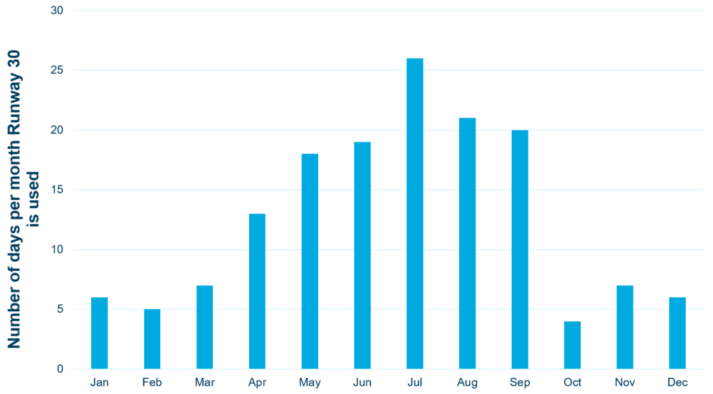
This means that Hobart’s seasonal wind patterns affect usage of the different runway directions.
Summer
During summer, when afternoon sea-breezes are common, the wind varies so both Runway 12 and Runway 30 are used.
Runway 30 is mostly used in the morning (8-9am) and evening (8-9pm) and Runway 12 is mostly used during the day (10am-5pm).
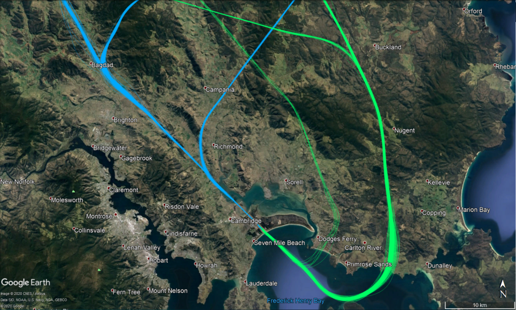
The flight paths in use change depending on the runway being used.
When Runway 12 is used, aircraft depart to the south before turning north and crossing the coast near Connellys Marsh (jets) or Dodges Ferry/Carlton (non-jets). Aircraft arrive from the north using two approach paths (depending on the technology available on-board the aircraft) near Campania or Bagdad.
When Runway 30 is used, aircraft depart to the north before turning near Bagdad (jets) or Richmond (non-jets). Aircraft arrive from the south using two approach paths (depending on the technology available on-board the aircraft), crossing the coast near Carlton/Primrose Sands or Connellys Marsh.
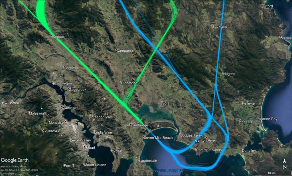
Most of the year
The prevailing wind is north-westerly for most of the year (approximately 75% of the year), meaning that Runway 30 is used most frequently.
The flight paths in use are most often those for Runway 30.
When Runway 30 is used, aircraft depart to the north before turning near Bagdad (jets) or Richmond (non-jets). Aircraft arrive from the south using two approach paths (depending on the technology available on-board the aircraft), crossing the coast near Carlton/Primrose Sands or Connellys Marsh.
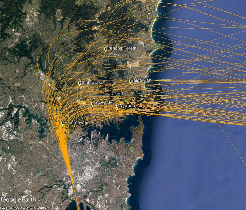
Note: All tracks have been displayed. Track colours have been adjusted to show track density. Where aircraft are more concentrated the colour will appear darker.
On occasion heavy jets bound for destinations in the United States will pass over your area after departure.
Heavy jets need to use the westernmost parallel runway because it is longer. After departing towards the north from the westernmost parallel runway, aircraft bound for the USA usually turn and track to the west once they reach 1,500 feet. At twelve nautical miles they turn to the north east to track out across the coast. These outbound aircraft need to pass over inbound traffic that is flying south down the coast. For this to occur safely the outbound jets must have reached a specified altitude. However some very large aircraft on non-stop flights are so heavily laden with fuel that their climb performance is affected and they cannot reach the required altitude in time.
When this is the case the aircraft is provided with a “radar departure”, where air traffic control provide a specific heading to ensure the aircraft can pass safely through the inbound traffic. This means these aircraft fly a different route than would normally be expected, including passing over different suburbs. The route will vary for each individual aircraft depending on what other traffic is in the airspace at the time. This creates a spread across suburbs to the north of the airport.
Because there are only a small number of these flights each day, and because the suburbs overflown by each aircraft vary, residents may notice these flights as unusual for their areas.
The image below of actual aircraft tracks shows a month of flights and illustrates the spread across many suburbs.
Visit Engage Airservices to engage with our program of flight path and airspace changes.
Airport Master Plans
Airport Master Plans provide a blueprint for the future development of an airport over a twenty year period. They include information on forecast growth, airport terminals and facilities, runways and flight paths.
Who is responsible for master planning?
Airports are responsible for producing the master plan.
Aircraft usually take-off and land into the wind for safety and performance reasons. As the wind direction changes the runway in operation and the flight paths being used may also change.
This means that Adelaide’s seasonal wind patterns affect usage of the different runway directions. The prevailing wind is southerly for most of the year, meaning that Runway 23 is used the most frequently. During the cooler months Runway 05 typically receives more use than at other times of the year because there tends to be more northerly winds.
If the wind is light or calm the direction the runway is used is determined by other factors such as Noise Abatement Procedures (NAP) or air traffic management requirements.
As we gather more data on operations we will update this section with more information.