The purpose of this review is to summarise Airservices investigation into community-initiated proposals for changes for flight paths to and from the south of Gold Coast Airport (‘Southern Operations’).
Investigation: Southern Operations

The purpose of this review is to summarise Airservices investigation into community-initiated proposals for changes for flight paths to and from the south of Gold Coast Airport (‘Southern Operations’).
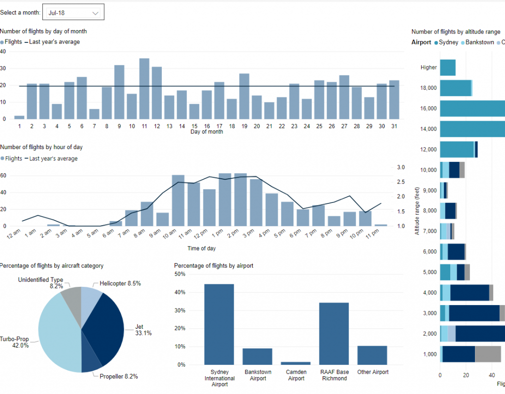
Use this interactive tool to explore detailed data for your area in the month of your choice.
This report is best viewed in full screen mode.
*Please note due to technical issues between 19 June and 22 June 2024, flight data may not be accurately displayed. Our supplier is working to resolve the issue. We apologise for any inconvenience this may cause.
The practice of direct tracking arrivals to Runways 21 and 24 over Stoneville and Parkerville, northeast of the airport, was addressed. “Direct tracking” involves taking an aircraft off the standard flight path and giving it a shorter route. This now only occurs when it is operationally required, for example, for traffic management reasons to ensure separation is maintained.
In November 2014, Airservices implemented a change of procedure that will require jet aircraft departing on Runway 35 to reach a ‘waypoint’ around 10 kilometres from the runway north of Canberra suburbs before turning left, rather than as soon as they reach 7 000 feet. This will result in jet aircraft flying over non-residential land rather than residential areas of Gungahlin.
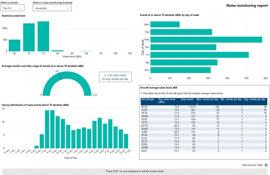
Use this interactive tool to explore monthly noise monitoring data.
This report is best viewed in full screen mode.
To learn more about noise monitor terminal locations visit our Canberra Noise and Flight Path Monitoring System page.
Noise Abatement Procedures at Perth allow aircraft to be taken off Standard Instrument Departure (SID) procedure tracking once jets are at 5000 feet above ground level and non-jets 3000 feet except where impractical in the normal course of operation to and from the runways. This provision is primarily in place to assist the efficient management of aircraft close to the airport during peak periods.
In response to community concerns about the minimum height of aircraft over residential areas, Airservices held a trial from December 2013 to February 2014 for all aircraft flying to the east of Perth to maintain SID tracking until leaving 8000 feet except where required for operational reasons.
A Post Implementation Review of the trial was completed in December 2014. While community feedback was limited, Airservices concluded there was a noticeable benefit from the trial and that the change should be permanently implemented in Perth Airport’s Noise Abatement Procedures. This change was permanently implemented on 28 May 2015.
Airservices identified an opportunity to modify the flight path for aircraft arriving from the north to land on the southern end of the Runway 03 at Perth Airport which would move aircraft away from Bickley, Byford, Carmel, Martin and Roleystone and closer to Bickley East, Karragullen and Pickering Brook which had smaller populations.
A Post Implementation Review of the trial was published in February 2015. The review found that community feedback demonstrated a noticeable benefit had been achieved from the trial and that as a result the change should become permanently implemented. Airservices actioned this on 5 March 2015.
Visit Engage Airservices to engage with our program of flight path and airspace changes.
Airport Master Plans provide a blueprint for the future development of an airport over a twenty year period. They include information on forecast growth, airport terminals and facilities, runways and flight paths.
Airports are responsible for producing the master plan.
The Canberra Airport Master Plan can be found on the Canberra Airport website.
Arriving aircraft from the east that are making an instrument approach to Runway 03 (long straight-in approach to the southern end of the main runway) converged at a point near Bedfordale. Airservices proposed to move this converging point some 8-10 kilometres to the east to reduce the number of aircraft impacting the Bedfordale area. This change came into effect on 5 March 2015.
Powered by: 