Learn about flight paths and aircraft movements in your area
Welcome to the Aircraft in Your Neighborhood Portal
Our goal is that you will learn more about the flight paths and aircraft movements in your area and be able to access the information and resources that explain how air traffic is managed.
First, please select your location using one of the following options, so that we can customize the information for your location.
We’ll remember your location so you don’t have to enter it every time you visit the site and we’ll keep this information confidential.
Please note, that this site works best on Chrome, Firefox and Edge.
* Mandatory - Select region first to view the map.
Federally-leased airports (excluding Mt. Isa and Tennant Creek) have established Community Aviation Consultation Groups (CACGs), which provide an effective avenue for local community engagement on airport planning and operations, including aircraft noise. The Department for Infrastructure, Transport, Regional Development and Communications provides guidelines for CACGs.
Non federally-leased airports may also choose to establish CACGs or community forums.
CACG membership depends on the characteristics of the airport and any local issues of community concern however, generally includes:
airport management
aircraft operators
community organisations or representatives
representatives from state, territory or local government bodies
local tourism and business groups.
Airservices does not formally belong to CACGs, but is invited to attend to provide relevant information and assist in discussions. We engage with CACGs on flight path and airspace changes, as well as technical reviews, such as noise monitoring and noise abatement procedures.
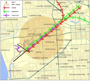
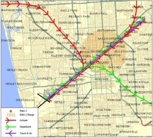
A designated training area exists to the north-west of the airport and to the west and north-west of the RAAF Edinburgh Base. Once pilots progress past the circuit training stage of their courses they will begin flying to and around the training area.
Click to enlarge the image, right, and use your browser “back” button to return to this page.
The training area is outside controlled airspace. It extends from St Kilda, which is approximately 10 kilometres west-north-west of the airport, to Long Plains, which is a further 45 kilometres to the north-west of St Kilda. The training area is to the west of this line and extends to 9 kilometres off the coast. It is ‘wedge-shaped’ because it is located in-between military restricted airspace to the west and north and the RAAF Edinburgh Base Control Zone to the east.
From the St Kilda area to just south of Middle Beach the training area exists between the surface (“SFC”) and 2500 feet. North to Long Plains the area extends between the surface and 4500 feet. These levels keep the aircraft below controlled airspace; therefore aircraft do not need a clearance from air traffic control to operate in the training area.
Aircraft wishing to track to the training area from Parafield Airport must remain south of the Bolivar strobe light and west of St Kilda to remain outside controlled airspace. The north- and southbound VFR routes (described above) transit the area.
Activities that may occur inside the training area include parachute operations and light aircraft movements at Lower Light aircraft landing area, as well as training flights by light aircraft in and around the area and aircraft transiting on the north and southbound VFR routes. There can be increased traffic volumes in the area due to use by flight training companies from Parafield Airport and because all aircraft are confined to a relatively small area due to the surrounding military airspace including RAAF Base Edinburgh.
The illustration below shows how jet and non-jet (turbo-prop) aircraft typically operate at Adelaide Airport on the published instrument arrival and departure flight paths.
The animation is indicative only and provided for information purposes, on occasions flights may leave these general areas from time-to-time.
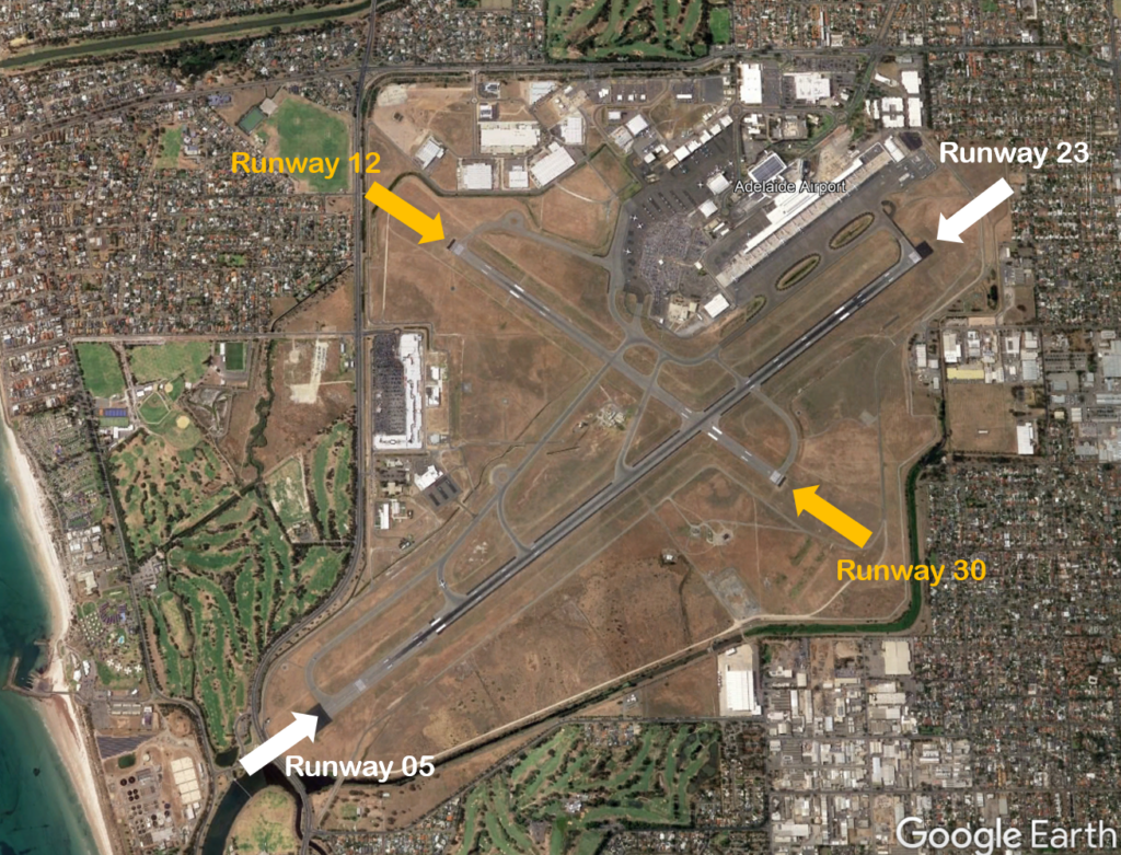
The main runway at Adelaide Airport, Runway 05/23 is 3 kilometres long and is orientated south-west to north-east. There is a smaller 1.6 kilometre cross runway, Runway 12/30, which is orientated north-west to south-east. The cross runway is primarily used by propeller aircraft.
Each runway is referred to differently according to in which direction it is being used. For example the main runway is known as Runway 05 when used in a north-easterly direction and 23 when used in a south-westerly direction. Runway numbering reflects the runways’ orientation and correlates with degrees on a compass. Runway 23 is 230 degrees.
The following video explains how runways are named and used.
Runway selection and seasonal winds
Runway selection is based on wind direction, weather conditions, traffic volume and other factors. Aircraft primarily take-off and land into the wind for safety and performance reasons. Therefore, as the wind direction changes the runway in operation may also change depending on the strength of the wind.
This means that Adelaide’s seasonal wind patterns affect usage of the different runway directions. The prevailing wind is southerly for most of the year, meaning that Runway 23 is used the most frequently. During the cooler months Runway 05 typically receives more use than at other times of the year because there tends to be more northerly winds.
Noise abatement procedures
Noise abatement procedures are designed to help reduce the impact of aircraft noise on communities. While they are applied whenever it is possible to do so, their use is not mandatory and is subject to weather conditions and traffic requirements.
In Adelaide the noise abatement procedures set out the preferred runway configuration for use during specific periods of the day. Between 6 am and 11 pm the most preferred runway is Runway 23 (arrivals over the suburbs and departures over the water), followed by Runway 05 as a second preference. If Runway 23/05 is not available, the preferred runway is Runway 30 and the second preference is Runway 12.
There are a number of factors that influence the frequency of flights.
Firstly, the number and frequency of flights will vary on a daily, weekly and yearly basis due to differences in airline schedules. The airlines schedule flights in response to consumer demand. This is particularly the case around Christmas, Easter, school holidays and Lunar New Year.
Secondly, the runway in use at any given time will also vary, largely due to the wind conditions. Each runway has its own set of flight paths, and each flight path will affect different areas. As the runway in use changes, the flight paths change, and so too do the areas affected by aircraft movements.
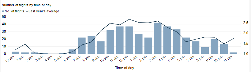
This chart shows the total number of flights each hour over the month, compared to the average for last year. Change the selected month to see how it has varied.
*Please note due to technical issues between 19 June and 22 June 2024, flight data may not be accurately displayed. Our supplier is working to resolve the issue. We apologise for any inconvenience this may cause.
*Please note due to technical issues between 19 June and 22 June 2024, flight data may not be accurately displayed. Our supplier is working to resolve the issue. We apologise for any inconvenience this may cause.
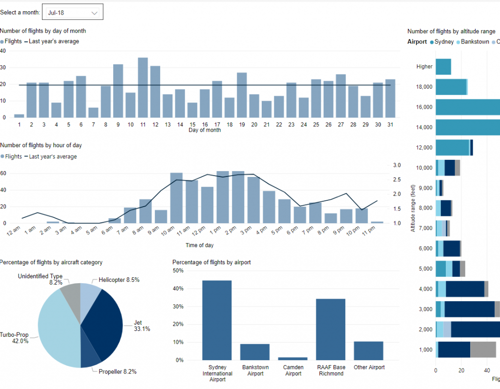
Use this interactive tool to explore detailed data for your area in the month of your choice.
This report is best viewed in full screen mode.
*Please note due to technical issues between 19 June and 22 June 2024, flight data may not be accurately displayed. Our supplier is working to resolve the issue. We apologise for any inconvenience this may cause.
Federally-leased airports (excluding Mt. Isa and Tennant Creek) have established Community Aviation Consultation Groups (CACGs), which provide an effective avenue for local community engagement on airport planning and operations, including aircraft noise. The Department for Infrastructure, Transport, Regional Development and Communications provides guidelines for CACGs.
Non federally-leased airports may also choose to establish CACGs or community forums.
CACG membership depends on the characteristics of the airport and any local issues of community concern however, generally includes:
airport management
aircraft operators
community organisations or representatives
representatives from state, territory or local government bodies
local tourism and business groups.
Airservices does not formally belong to CACGs, but is invited to attend to provide relevant information and assist in discussions. We engage with CACGs on flight path and airspace changes, as well as technical reviews, such as noise monitoring and noise abatement procedures.
Circuit training is the first stage of practical pilot training focused on take-offs and landings. It involves the pilot making approaches to the runway or helipad, touching down and then applying power to take off again. This is undertaken in accordance with Civil Aviation Safety Authority (CASA) Regulations which are consistent with international practices.
How circuits are conducted
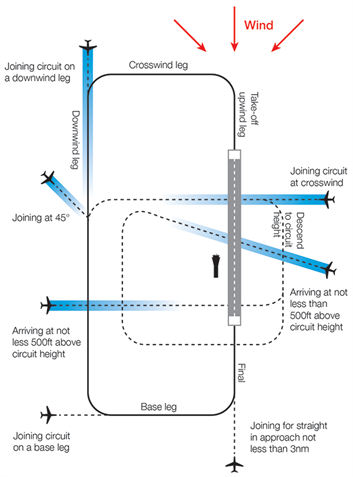
A training circuit consists of five legs – take-off, crosswind, downwind, base and final approach to the runway.
Aircraft take off into the wind, climb to 500 feet and then turn onto the crosswind leg. They continue to ascend to 1000 feet and turn onto the downwind leg. Having turned onto the base leg the descent commences. After turning onto the final leg and lining up with the runway the aircraft will touch down and take off again.
Helicopters circuit inside the fixed wing circuit at a lower altitude. When helicopters are training, the fixed wing pilots must extend the take-off leg by one nautical mile to increase the separation between the two types of aircraft. This has the effect of extending the area overflown.
Because Parafield Airport has two sets of parallel runways, this allows two circuits to operate at once. “Left-hand” circuits will be conducted from the left parallel runway, and “right-hand” circuits from the right runway. For left-hand circuits, the pilot turns left after take-off and flies anticlockwise. For right-hand circuit, the pilot turns right and flies in a clockwise direction.
A simplified representation of a left-hand circuit is shown at right. The take off and final stage of the circuit is flown into the wind, as this is the safest way for an aircraft to operate. The aircraft symbols and dotted lines indicate recommended ways for an aircraft to join the circuit pattern. Click the image to enlarge it, and use your browser “Back” button to return to this page.
As twin engine aircraft are generally faster than single engine aircraft, both types are generally, but not always, separated. When using the main runways, Runways 03/21, twin engine aircraft generally operate to the west and single engine aircraft to the east.
When winds dictate use of Runways 08/26 twin engine aircraft generally circuit to the north and single engine aircraft to the south.
Parafield Airport’s voluntary Fly Friendly Program asks signatories to keep circuits as narrow as possible. However, because the student pilots performing circuits are so new to flying, this is not always achievable.
More information about circuit training is found here.
Animation of the Parafield circuit
The animated aircraft below and the static tracks shown in blue are created from actual tracks flown by aircraft in the circuit. This illustrates the degree of variation that will occur in the way student pilots fly circuits. The altitudes above mean sea level of the aircraft are also shown.
You can enlarge to full-screen by clicking the square-shaped button in the bottom right-hand corner of the player.
To replay the animation press the “Replay” button in the bottom left-hand corner of the player.
Effects of runway direction
Air traffic control will determine which runways are used at any given time depending on the direction of the wind – this is because aircraft must generally take off and land into the wind for safety reasons. Depending on which runway direction is in use, different suburbs will be affected by different legs of the circuit. The Noise Complaints and Information Service tends to receive more complaints from suburbs under the crosswind and base legs of the circuit. This is the case at all airports where circuit training occurs.
When the north-south runways are being used in a northerly direction, (Runways 03 Left and Right), Gulfview Heights, Salisbury South, Brahma Lodge and Salisbury Gardens will be affected by the crosswind leg and Mawson Lakes, Pooraka and Ingle Farm will be affected by the base leg. The opposite is true when these runways are being used in a southerly direction, (Runways 21 Left and Right).
Circuit Training hours
Training during both day and night is important for developing pilot competencies, as is experience with using different types of navigational aids.
Circuit training times are set out in the Noise Abatement Procedures for Parafield Airport and are:
Monday to Friday: 7:00am – 11:00pm Saturdays: 7:00am – 9:00pm Sundays: 8:30am – 9:00pm Christmas Day: No circuit training New Years Day: No circuit training Anzac Day: 9:00am – 11:00pm
Please note that these times above apply only to circuit training, and not to arriving and departing aircraft which may operate 24 hours a day.
On weekdays circuit training will cease by 10:00pm where possible. However this is subject to operational requirements and as such it may extend until 11:00pm as permitted under the Noise Abatement Procedures.
At night all aircraft circuit to the west. There is only one lit runway, Runway 03 Left / 21 Right and therefore aircraft can only fly on the western circuit. Due to flying training courses running on different schedules, this will mean some nights will have multiple aircraft operating and other nights none at all.
While there are set times for circuit training it is important to note that when aircraft are arriving outside control tower hours they are required to fly a circuit before landing for safety reasons. Therefore it may seem like aircraft are flying circuits outside hours when this is not the case.
Altitudes
Aircraft aim to fly at 1000 feet on the downwind leg. Helicopters will fly at 800 feet to separate them from the fixed wing aircraft which will usually fly faster. Note that these altitudes apply only to the downwind leg. This is because aircraft are ascending on the take-off and crosswind legs and descending on the base and final legs.
While attaining 1000 feet on the downwind leg is the aim, in reality the altitudes of aircraft that are conducting circuit training will always vary. Part of the reason for this is that the trainees are new to flying and factors such as their level of experience and even their degree of nervousness will affect the altitudes they can achieve. Unfortunately the nature of circuit training is to teach new pilots and therefore this variation cannot be avoided.