Bankstown Airport circuits

Circuit training is the first stage of practical pilot training, focused on take-offs and landings. It involves the pilot making approaches to the runway, touching down and then applying power to take-off again.

Circuit training is undertaken at most airports, particularly regional and general aviation aerodromes. How a circuit is flown and its location is determined by the Civil Aviation Safety Authority.

The animation below shows how a circuit is typically flown. it has been created using typical tracks which are shown in blue whilst an animated aircraft flies the circuit. The circuit will only be used by one aircraft at any given time.

The animation illustrates the degree of variation that will occur in the way pilots fly circuits. The altitudes above mean sea level of the aircraft are also shown. You can enlarge to full-screen by clicking the square-shaped button in the bottom right-hand corner of the player.

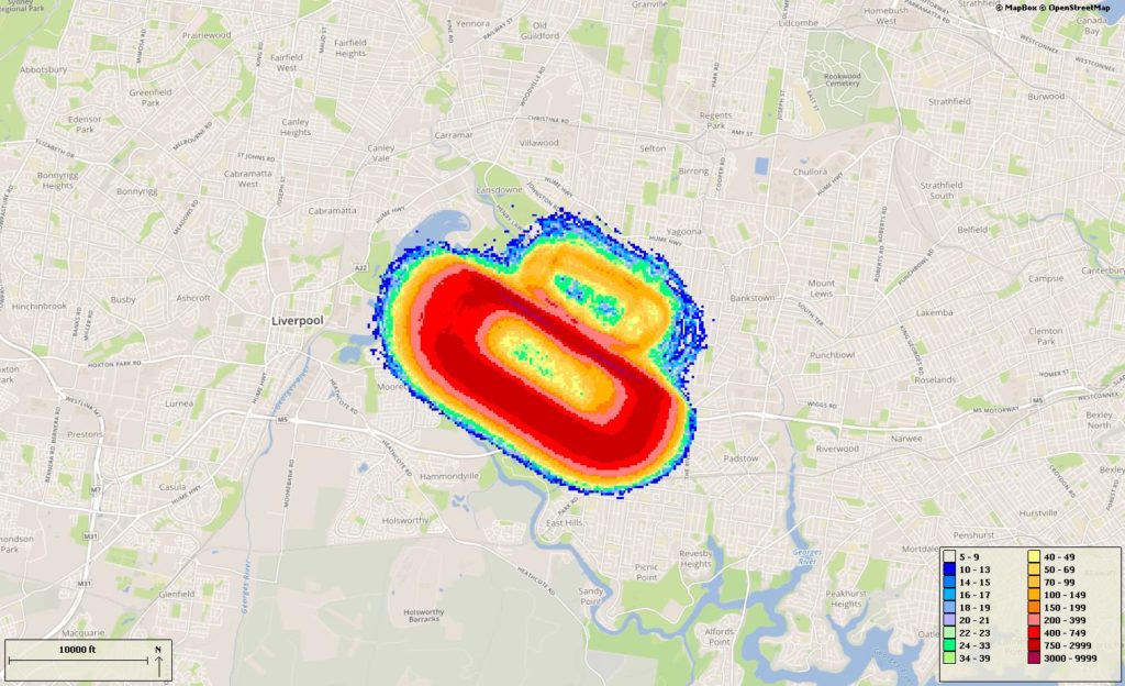
The following image shows the density of aircraft in the circuit over a the quarter. The colour indicates the density – the hotter and deeper the colour, the greater the number of movements.
Important information for residents near circuit training airports

Aircraft movement information in this portal may inaccurately count some low-level flights at Secondary airports.

Why is this so?

The aircraft movement data comes from the radar located close to the major airport which is used by air traffic control to manage aircraft within controlled airspace.  Low-level flights around secondary airports, such as circuit training flights, can be partially hidden from the radar’s line of sight by buildings and hills, potentially making counts inaccurate.

Learn more

Learn more about how radar coverage affects counting of low-level aircraft movements at secondary airports in our Help and Technical Information page, available in the resources section.

Camden Airport circuits

Circuit training is the first stage of practical pilot training, focused on take-offs and landings. It involves the pilot making approaches to the runway, touching down and then applying power to take-off again.

Circuit training is undertaken at most airports, particularly regional and general aviation aerodromes. How a circuit is flown and its location is determined by the Civil Aviation Safety Authority.

The animation below shows how a circuit is typically flown. it has been created using typical tracks which are shown in blue whilst an animated aircraft flies the circuit. The circuit will only be used by one aircraft at any given time.

The animation illustrates the degree of variation that will occur in the way pilots fly circuits. The altitudes above mean sea level of the aircraft are also shown. You can enlarge to full-screen by clicking the square-shaped button in the bottom right-hand corner of the player.

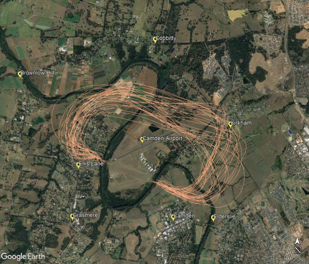
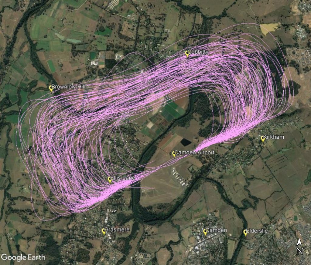
The following images show the typical paths taken by aircraft flying the circuit at Camden using both runways available at the airport. The runway direction is selected using the wind direction.

Circuits conducted on the north-west side of the airport with Ellis Lane and Cobbity affected by either the crosswind or base legs as shown in the image below.

Circuits conducted on the north-east side of the airport with and parts of Ellis Lane and Kirkham affected by the crosswind and base legs as shown in the image below.

For information on circuit training hours and aircraft altitudes see our Camden Airport Rules page.

Important information for residents near circuit training airports

Aircraft movement information in this portal may inaccurately count some low-level flights at Secondary airports.

Why is this so?

The aircraft movement data comes from the radar located close to the major airport which is used by air traffic control to manage aircraft within controlled airspace.  Low-level flights around secondary airports, such as circuit training flights, can be partially hidden from the radar’s line of sight by buildings and hills, potentially making counts inaccurate.

Learn more

Learn more about how radar coverage affects counting of low-level aircraft movements at secondary airports in our Help and Technical Information page, available in the resources section.
Bankstown and Camden Airport – Training areas

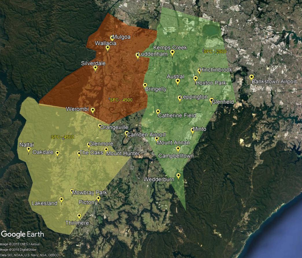
There are a number of designated flight training areas to the west and south-west of Bankstown Airport and surrounding Camden Airport. Once pilots progress past the initial circuit training stage of their learning they will begin flying to and around these training areas.

Training areas

These areas extend from ground level to between 2,500 feet to 4,500 feet. The closer the training area is to Sydney Airport, the lower the upper limit will be to ensure that aircraft do not conflict with arrivals and departures using Sydney Airport.

In addition to pilot training, activities including model aircraft flights, ultralight aircraft flights, as well as aerobatic flights can occur. Parachute jumping generally occurs to the south of the training areas over the Wilton aerodrome area. Transiting aircraft may also track over the area.

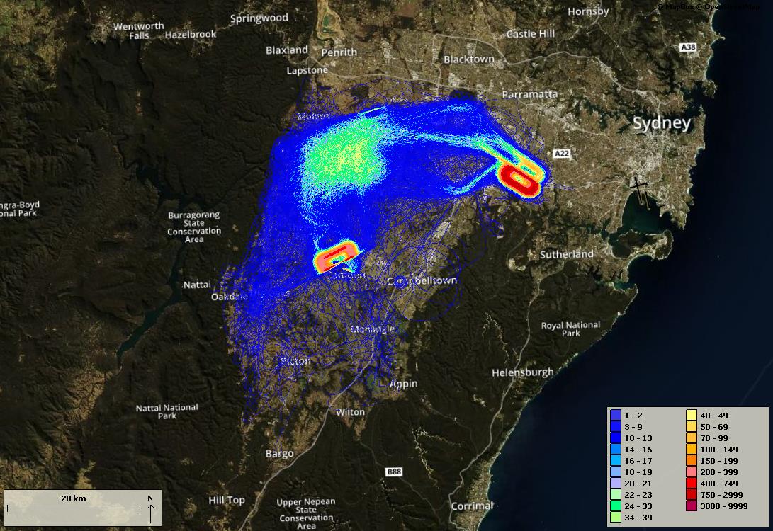
The training areas are outside controlled airspace. This means that aircraft are not being directed by air traffic control. The following image shows the density of aircraft using the training areas and flying between the training areas, Camden and Bankstown Airports over a typical three-month period.

The colour indicates the density – the hotter and deeper the colour, the greater the number of movements. The legend in the bottom right-hand corner indicates the number of movements per quarter depicted by each colour.

Track density

Sydney Airport – operations in poor weather

Precision Radar Monitor (PRM) is a technique used in poor weather to ensure safe and efficient operations at Sydney Airport. PRM can only be used in weekday morning peak periods, that is, between 7am and 11am, Monday to Friday.

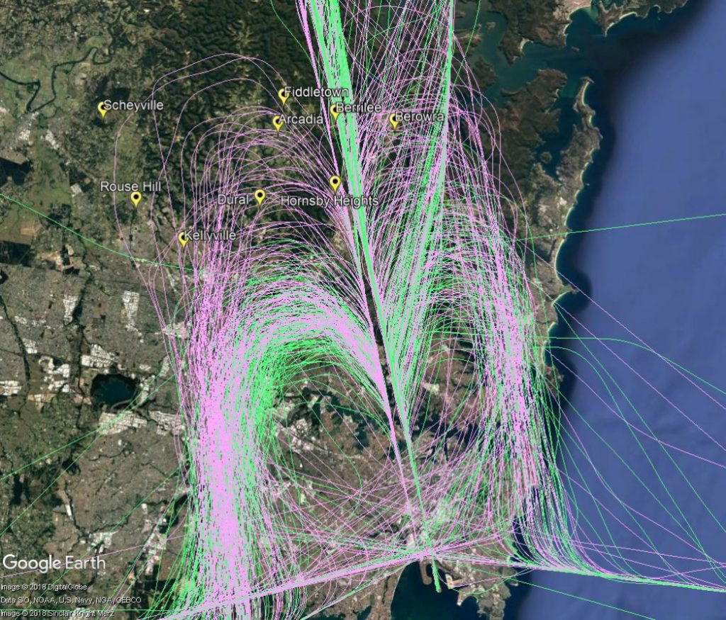
An effect of PRM operations is that aircraft are required to align with the runway five to ten kilometres further north of the airport. These aircraft will overfly suburbs and townships to the north-west and north of Sydney that do not usually experience overflight from arriving aircraft, such as Kellyville, Dural, Hornsby Heights, Arcadia and Fiddletown. Other areas that are already overflown by arrivals, such as Cherrybrook, Hornsby, Berrilee and Berowra, will experience more traffic when PRM is in use.

The following image of actual aircraft tracks illustrates this. The green tracks are aircraft making approaches at times when PRM is not being used. The pink tracks are flights during PRM operations.

PRM and non-PRM operations

The Gold Coast Noise and Flight Path Monitoring System (NFPMS)

We have commenced a Noise Monitoring Review for Gold Coast Airport.

The purpose of the Review is to:

  • Validate the operation of the two existing long-term noise monitors (Tugun and Banora Point)
  • Consider and assess community suggested locations for a third long-term noise monitor in the Tweed Heads region or another suitable location in the broader Gold Coast region
  • Provide findings to the Gold Coast Airport Noise Abatement Consultative Committee (ANACC)

For more information, including how to participate in the Review visit Engage Airservices.

We collect noise and operational data from two noise monitors (Environmental Monitoring Unit, EMU) around Gold Coast Airport. Noise monitors are listed below according to their location.

Access monthly data on our Gold Coast noise monitoring reports page.

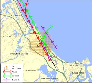
TUGUN (EMU 1)

Captures arrivals to Gold Coast Runway 14 and departures from Gold Coast Runway 32.
The pattern of aircraft noise events recorded is relatively steady.
Click to enlarge image and use your back button to return to this page.

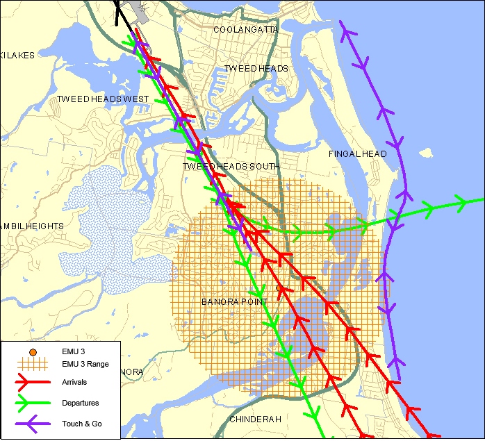
BANORA POINT (EMU 3)

Captures arrivals to Gold Coast Runway 32 and departures from Gold Coast Runway 14.

Click to enlarge image and use your back button to return to this page.


Learn more about monitoring aircraft noise on the Airservices website.

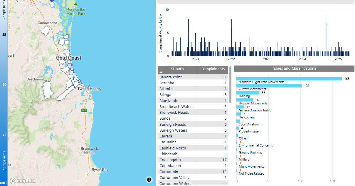
Gold Coast complaints report

We manage complaints and enquiries about aircraft noise and operations through our Noise Complaints and Information Service (NCIS). The information below is collected for the purpose of complaint management, analysis of issues and identification of causal factors.

For this reason we refer to ‘complainants’ and ‘issues’. Complainants are people who contacted us. While some people submitted enquiries or comments rather than complaints, all are referred to as “complainants”. Issues are the primary concern they raised.

The complaints report

Use this interactive tool to explore the issues raised by residents from different suburbs. For help, click the button in the bottom right-hand corner.

This report is best viewed in full screen mode.

Read an explanation of issues and classifications used in complaint reporting.

Making an aircraft noise complaint

At Airservices, we regard the safety of air navigation as the most important consideration and as far as practicable we work to protect the community and environment from the effects of aircraft operations, including aircraft noise.

We manage complaints and enquiries about aircraft operations and Airservices Australia’s community engagement activities through our Noise Complaints and Information Service (NCIS). We use complaints and enquiries to help us identify operations of concern and possible opportunities for improvement.

When you contact us, please provide your contact details and as much information about your complaint or enquiry as possible.

You may choose to remain anonymous on the webform, or when calling or writing to us. To receive a response, we require some details including your suburb or location to identify the operations you are enquiring about and an email address to send the response to. By providing your details, we may also send you updates on relevant flight path changes and other Airservices activities in your area.

We will not respond to any submissions that contain threatening, abusive, discriminatory, racist, offensive, obscene, vulgar, profane and inflammatory language. Threatening or unlawful comments may be reported to the relevant state and federal authorities.

If you feel negatively impacted by aircraft noise, you could consider reaching out to one of the following support services:

  • Lifeline 24 hr Counselling Service: 13 11 14
  • Beyond Blue: 1300 224 636

Airservices Australia has extended our Employee Assistance Program to any community member who is feeling negatively affected by aircraft noise. This is a confidential service, free of charge to community members, and is provided completely independently of Airservices Australia. All personal details will be kept confidential. More information is available here or you can call 1300 687 327. If requested, please use “organisation code” AIRSUPPORT and if asked for a “division” please use Community Support.

Phone

1800 802 584 (freecall), 10am – 4pm (Sydney time), Mon – Fri (excluding public holidays)

Post

Noise Complaints and Information Service, PO Box 211, Mascot NSW 1460

Interpreter assistance

If you need assistance, please contact the Telephone Interpreter Service (TIS) on 131 450.

TIS is a free service that provides access to a telephone interpreter in many different languages.

Other Complaints

NCIS is the Australian aviation industry’s main interface on aircraft noise and related issues for the community. If you have a complaint that does not relate to aircraft noise, visit the Australian Government’s Aviation Complaints website to find the right place to direct your complaint.

Sydney Airport – heavy departures to the United States

On occasion heavy jets bound for destinations in the United States will pass over your area after departure.

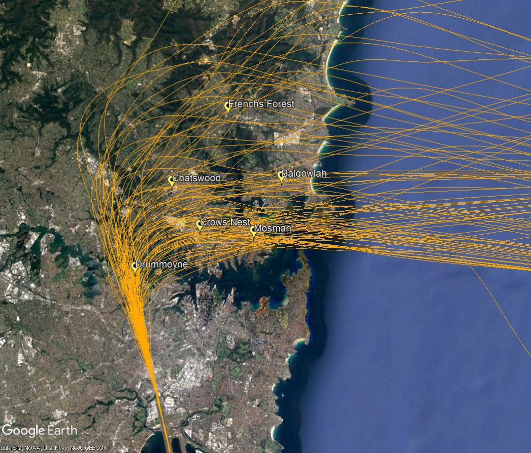
Heavy jets need to use the westernmost parallel runway because it is longer. After departing towards the north from the westernmost parallel runway, aircraft bound for the USA usually turn and track to the west once they reach 1,500 feet. At twelve nautical miles they turn to the north east to track out across the coast. These outbound aircraft need to pass over inbound traffic that is flying south down the coast. For this to occur safely the outbound jets must have reached a specified altitude. However some very large aircraft on non-stop flights are so heavily laden with fuel that their climb performance is affected and they cannot reach the required altitude in time.

When this is the case the aircraft is provided with a “radar departure”, where air traffic control provide a specific heading to ensure the aircraft can pass safely through the inbound traffic. This means these aircraft fly a different route than would normally be expected, including passing over different suburbs. The route will vary for each individual aircraft depending on what other traffic is in the airspace at the time. This creates a spread across suburbs to the north of the airport.

Because there are only a small number of these flights each day, and because the suburbs overflown by each aircraft vary, residents may notice these flights as unusual for their areas.

The image below of actual aircraft tracks shows a month of flights and illustrates the spread across many suburbs.

Heavy departures