Learn about flight paths and aircraft movements in your area
Welcome to the Aircraft in Your Neighborhood Portal
Our goal is that you will learn more about the flight paths and aircraft movements in your area and be able to access the information and resources that explain how air traffic is managed.
First, please select your location using one of the following options, so that we can customize the information for your location.
We’ll remember your location so you don’t have to enter it every time you visit the site and we’ll keep this information confidential.
Please note, that this site works best on Chrome, Firefox and Edge.
Training during both day and night is important for developing pilot competencies, as is experience with using different types of navigational aids.
Circuit training times are set out in the Noise Abatement Procedures for Camden Airport. These are:
Monday to Friday, non-daylight saving periods: 7:00am – 10:00pm
Monday to Friday, daylight saving periods: 7:00am – 10:30pm
Weekends: 7:00am to 8:00pm
Due to flying training courses running on different schedules, some nights will have multiple aircraft operating and other nights none at all.
These times above apply only to circuit training, and not to arriving and departing aircraft which may operate 24 hours a day. When aircraft are arriving outside control tower hours they are required to fly a circuit before landing for safety reasons. Therefore it may seem like aircraft are flying circuits outside hours when this is not the case.
Altitudes
Aircraft aim to fly at 1,000 feet on the downwind leg. This is because aircraft are ascending on the take-off and crosswind legs and descending on the base and final legs.
While attaining 1,000 feet on the downwind leg is the aim, in reality the altitudes of aircraft that are conducting circuit training will always vary. Part of the reason for this is that the trainees are new to flying and factors such as their level of experience and even their degree of nervousness will affect the altitudes they can achieve. Unfortunately the nature of circuit training is to teach new pilots and therefore this variation cannot be avoided.
It is a common misconception that noise sharing means that flight paths are varied. This is not the case. Using the same standard flight paths is vital for safety, particularly at very busy airports like Sydney, because they reduce complexity for pilots and air traffic controllers. If a different flight path was used for every flight it would be very complex to ensure aircraft remained safely separated, and there would be a high possibility of confusion and error.
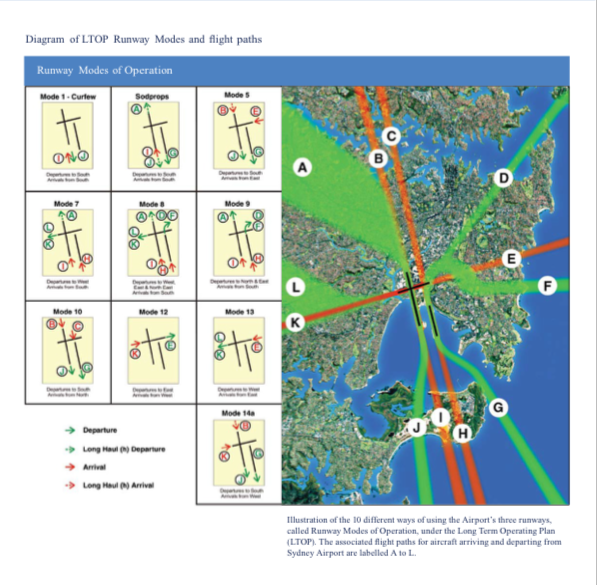
While flight paths themselves are not varied, there are different flight paths for each runway, each of which will affect a different part of the community. Because aircraft need to land and take off into the wind, the runway used generally will be the one that best suits the wind direction at the time. As the wind and other conditions change, the runway configuration or “mode” may also change, bringing a different set of standard flight paths into use. This has the effect of sharing the noise.
Peak period modes
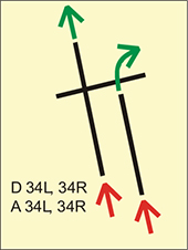
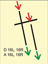
Modes 9 and 10 utilise both parallel runways at the same time. Mode 9 is a flow towards the north and Mode 10 is a flow towards the south.
During peak periods one of these parallel runway modes will always be used whenever the wind permits because using two runways at once enables the most traffic to be moved through the airport. The peak periods are generally from 7:00 – 11:00am and 3:00 – 8:00pm but may extend beyond these hours.
Noise sharing modes
During non-peak times for the airport air traffic controllers must implement a “noise sharing mode” whenever it is possible to do so according to the wind conditions and other factors. Non-peak times for the Airport are generally 6:00 – 7:00am, 11:00am – 3:00pm, 8:00pm – curfew.
Noise sharing modes generally use the east-west runway and the parallel runways. The modes that utilise the east-west runway can only be used when traffic volumes are low. This is because the east-west runway crosses both the parallel runways; the need for aircraft to cross active runways slows down operations significantly and in busy periods this would result in delays and holding in the air.
For all the noise sharing modes there is an option for pilots of heavy jets to request use of the longer westernmost parallel runway. In the images below this option is represented by dotted lines.
Mode 5
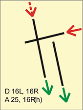
In Mode 5 the east-west runway is used for arrivals from the east and the parallel runways are used for departures towards the south.
Due to seasonal wind conditions, use of Mode 5 tends to rise as the weather cools.
Mode 7
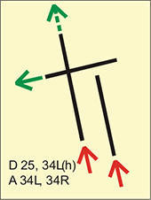
In Mode 7 the parallel runways are used for arrivals from the south and the east-west runway is used for departures towards the west.
Wind conditions in the cooler months tend to favour the use of Mode 7 and it is generally used more frequently at that time of year.
Mode 14a
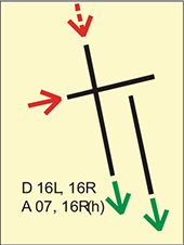
In Mode 14a the east-west runway is used for arrivals from the west and the parallel runways are used for departures towards the south, over the bay.
Mode 14a tends to be used more frequently in the warmer months due to favourable wind conditions.
SODPROPS
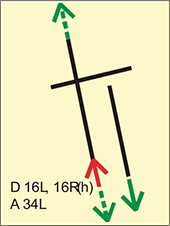
In Simultaneous Opposite Direction Parallel Runway Operations, (SODPROPS), aircraft arrive and depart over the bay. Arrivals use the westernmost parallel runway and departures use the easternmost parallel runway. This mode is the preferred noise sharing mode, however it can only be used when the wind and weather conditions are exactly right with maximum visibility for pilots and air traffic controllers in the Tower.
East-west runway only modes
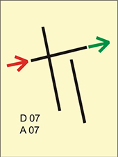
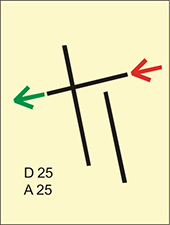
Modes 12 and 13 are used when the wind conditions preclude use of the parallel runways because the crosswind exceeds safety limits. If there is a very strong westerly wind, Mode 13 is used. If there is a very strong easterly wind, Mode 12 is used.
When one of these modes has to be used for extended periods it limits the amount of aircraft that can be moved through the airport. This results in delays which can have a cascading effect around the country.
Curfew mode
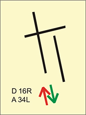
During the curfew, aircraft permitted to use the airport must arrive and depart from the westernmost runway. Emergency medical flights are exempt from this requirement and may use whichever runway will expedite their flight.

There is no legislation or regulation that restricts the number of flights that can fly over an area.
Sydney Airport has a legislated cap on movements that restricts the number of flights to a maximum of eighty per hour. This includes both arrivals and departures.
Airservices is charged with implementing this cap by counting movements per hour on a rolling 15-minute basis. If the cap is at risk of being exceeded air traffic controllers will take actions such as holding aircraft in the air or on the ground, to arrive or depart in the next hour.
The movement cap applies only to Sydney Airport. There is no limitation on the number of flights that can use other airports around Australia.
In Australia, aircraft noise standards apply before an aircraft is allowed to operate here, rather than in the course of its day-to-day flying activities.
Before an aircraft begins operating in Australia it is required to meet international noise standards that specify the amount of noise that may be emitted by that type or model of aircraft. If an aircraft does not pass the certification process, it may not fly in Australia. However once an aircraft passes this certification process, there is no legislation or regulation that enables any agency, including Airservices, to police its noise levels.
There is no regulated maximum noise level for aircraft flying over residential areas. Without any maximum level set out in legislation or regulation, there is no objective measure to determine whether any aircraft flying in Australia is “too noisy”, or whether the combined load of aircraft experienced by a community is “too much” noise.
The following video explains how our system calculates location-specific data used on this website:
The NFPMS
We source data directly from the Airservices Noise and Flight Path Monitoring System. The largest monitoring system in the world, combining data from air traffic control systems with a network of monitors deployed in local communities.
By using the location you provided when you entered the website, we extract data collected by this system and combine this with geographically relevant information, tailoring the site.
The grid
To be able to analyze the number of flights over your area, we have created a grid of identically sized, 1 kilometre by 1 kilometre squares. In total, the grid extends for 95 kilometres around each of the major airports in our coverage area. Initially this portal covers:
Adelaide
Brisbane
Cairns
Canberra
Gold Coast
Hobart
Melbourne
Perth
Sunshine Coast
Sydney
How we count the number of flights
We start by drawing a cone at the centre of each grid. Using the location that you provided when you entered the site, we determine the nearest cone to you.
Flights that pass through each cone are recorded and that data is presented on this website.
To avoid underestimating the flights in each area and to fully cover all locations in our grid, we lower the cone 2,600 feet (800 metres) into the ground.
The cone extends up to 15,000 feet (4.5 kilometres) above local ground level and at the very top, the cone is over 30,000 feet (9.4 kilometres) wide.
Why we use a cone
We use a cone because research undertaken by the United Kingdom Civil Aviation Authority identified that a cone best aligns with how we determine if an aircraft has overflown a location or not.
The 48.5-degree angle of the cone was selected as it incorporates an evaluation of noise, in that if one aircraft flew directly above the observer, followed by a second aircraft off to the side along the 48.5 degree line, the second aircraft would be 3 decibels quieter than the first.
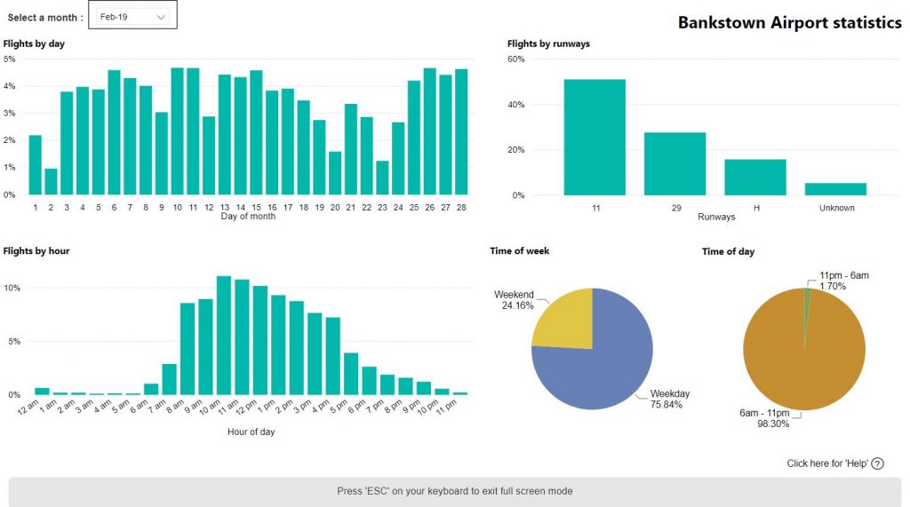
Use this interactive tool to explore Bankstown Airport statistics. Data is available from January 2017.
This report is best viewed in full screen mode.
The statistical breakdowns in the report are shown as percentages rather than total counts. This is because the source radar data for Bankstown Airport has gaps due to the location of the radar at Sydney Airport. As these gaps occur randomly throughout the day, the data, while incomplete, provides a representative picture of the weekly, hourly and day/night distribution of operations. You can read more about this on our Help and Technical Information page.
There are two types of airspace — controlled and uncontrolled.
Controlled airspace
Airservices air traffic controllers manage controlled airspace. To enter controlled airspace, an aircraft must first gain a clearance from air traffic control. In controlled airspace all aircraft must have continual radio contact with air traffic control and submit a flight plan detailing the route and height they will fly. Some emergency operations do not have to submit a flight plan, due to the urgency of their flights.
Uncontrolled airspace
All other airspace is uncontrolled. No clearance is required to operate in uncontrolled airspace and there is no supervision by air traffic control. Pilots operating in uncontrolled airspace must still comply with aviation regulations. However, they do not need to submit a flight plan and they may only have partial radio contact. The large majority of light aircraft and helicopters operate mostly in uncontrolled airspace.
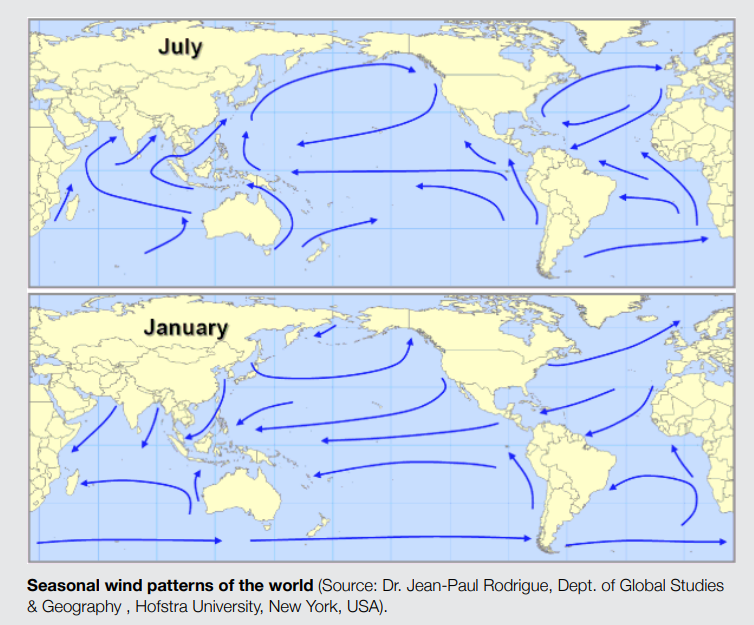
Because aircraft must take off and land into the wind for safety reasons, the runway selected for use will be the one that allows “into-wind” operations.
Wind patterns tend to be seasonal. This means that at some times of the year a runway and its associated flight paths may receive more use than at other times of the year.
The following image outlines the seasonal wind patterns and how they vary around Australia.
While helicopter routes exist, helicopters are not restricted to these routes. Inside controlled airspace helicopters must comply with directions from air traffic control whether flying on or off established routes. Outside controlled airspace aircraft, including helicopters, are not under the direction of air traffic control but they must comply with aviation regulations set down by the Civil Aviation Safety Authority.
Altitudes
The Civil Aviation Safety Authority have regulations for how low aircraft, including helicopters, can fly. These regulations require helicopter pilots fly no lower than 1,000 feet (ft) over built-up areas, or 500 ft over any other areas, unless they are landing or taking off.
Helicopters can fly below these heights in certain situations – for example, police, rescue, fire fighting and military helicopters may fly at any height required.
More information is available on the CASA website.
Hovering
There are no regulations or legislation that prevent helicopters from hovering over an area. For example, media helicopters are permitted to hover while covering a story or sporting event.
If a helicopter pilot wants to cross a ‘controlled’ zone around an airport, it is sometimes necessary for air traffic control to hold the helicopter in one place until it is safe to cross. This sometimes means helicopters have to hover over built up areas.
Responsibility for aviation operations is shared between a range of parties including Airservices, other federal government agencies, airlines and operators, pilots, airports and state and local governments.
AIRSERVICES AUSTRALIA (AIRSERVICES)
Airservices is Australia’s civil Air Navigation Service Provider (ANSP) to the aviation industry and provides aviation rescue firefighting services at 27 of Australia’s busiest airports. Airservices is a corporate Commonwealth entity established and governed by the Air Services Act 1995. Airservices publishes aeronautical data, maintains aviation telecommunication infrastructure and radio navigation aids, updates flight procedures and provides a national aircraft Noise Complaints and Information Service (NCIS).
AIRPORT OPERATORS
Airport operators are the decision-makers for all on-airport activities, including developing infrastructure to support aircraft operations, such as new runways, and safeguarding aviation operations. Airport operators may also develop noise management plans, limit aircraft movements, encourage quieter fleets, prepare long-term forecasting of aircraft noise around the airport, such as the Australian Noise Exposure Forecast (ANEF), and manage local community engagement.
AIRCRAFT OPERATORS
Aircraft operators are responsible for what is referred to as “noise at source”. They make decisions about what type of aircraft they operate, what engines they equip aircraft with, and which airports they fly those aircraft to. Aircraft operators can also modify aircraft to reduce noise impacts and invest in newer fleets. All these factors can impact the noise experienced on the ground.
CIVIL AVIATION SAFETY AUTHORITY (CASA)
The Civil Aviation Authority (CASA) is a government body that regulates Australian aviation safety. It sets rules that pilots, aircraft operators, air traffic controllers and airports must comply with. CASA validates the instrument flight procedures Airservices produces and is the ultimate approver of Airspace Change Proposals.
DEPARTMENT OF INFRASTRUCTURE, TRANSPORT, REGIONAL DEVELOPMENT, COMMUNICATIONS AND THE ARTS
The Department of Infrastructure, Transport, Regional Development, Communications and the Arts (the Department) is responsible for administering Minister approval of airport infrastructure projects for federally leased airports, generally submitted through a Major Development Plan (MDP) and Environmental Impact Statement (EIS), and for providing policy advice to the Minister on the efficient management of Australian airspace and aircraft noise and emissions. The Department can make recommendations to the Government on regulatory measures to manage aircraft noise. This department is also responsible for setting the requirement for federally leased airports to produce an ANEF.
DEPARTMENT OF CLIMATE CHANGE, ENERGY, THE ENVIRONMENT AND WATER
The Department of Defence is responsible for aircraft operations by military aircraft at military-controlled airports. They provide information, undertake community engagement and are responsible for managing complaints about military aircraft noise.
STATE AND LOCAL GOVERNMENT
State, Territory and Local Governments are responsible for land use planning around airports through zoning, subdivision control, and comprehensive planning actions. Local Governments may also be airport owners.
AIRCRAFT NOISE OMBUDSMAN
The Aircraft Noise Ombudsman conducts independent administrative reviews of Airservices and Department of Defence management of aircraft noise-related activities.