Learn about flight paths and aircraft movements in your area
Welcome to the Aircraft in Your Neighborhood Portal
Our goal is that you will learn more about the flight paths and aircraft movements in your area and be able to access the information and resources that explain how air traffic is managed.
First, please select your location using one of the following options, so that we can customize the information for your location.
We’ll remember your location so you don’t have to enter it every time you visit the site and we’ll keep this information confidential.
Please note, that this site works best on Chrome, Firefox and Edge.
* Mandatory - Select region first to view the map.
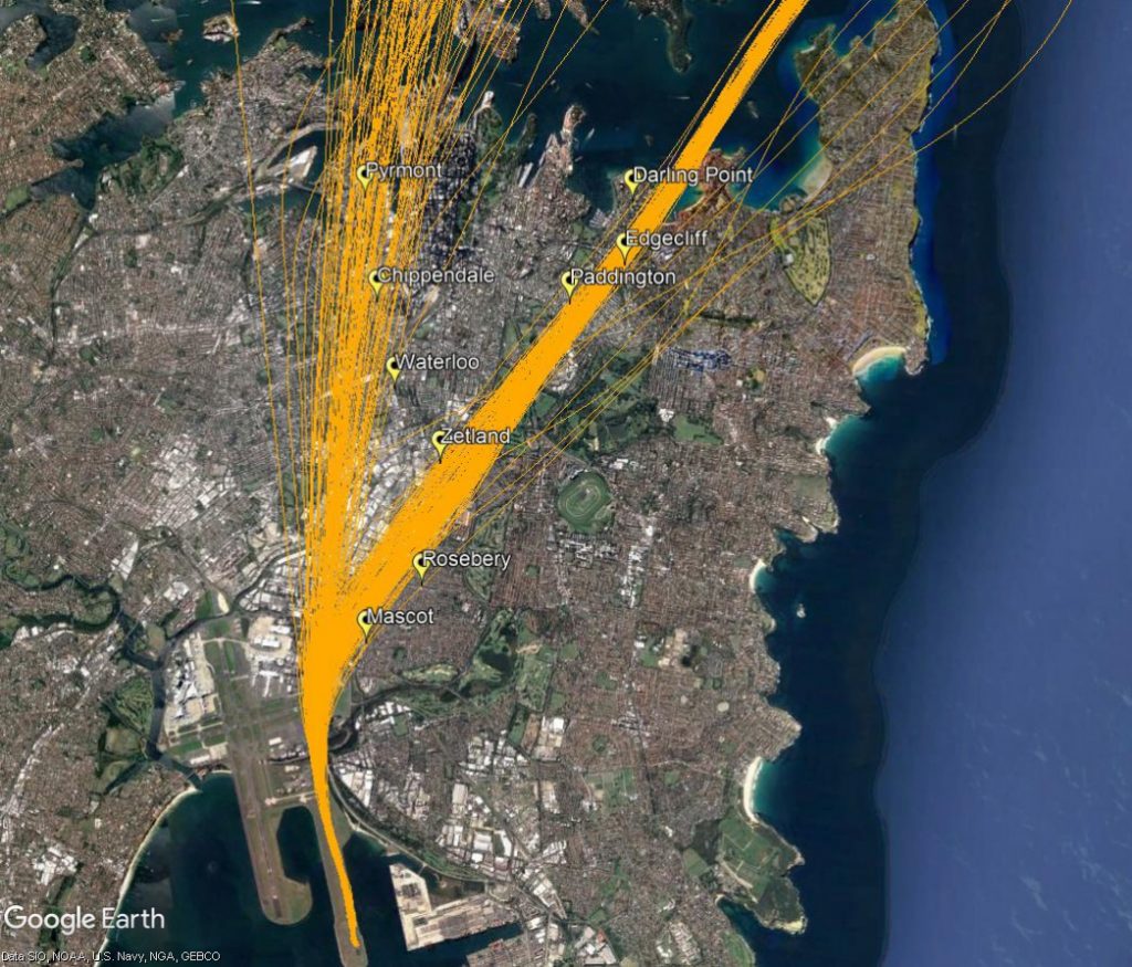
The eastern suburbs are primarily affected by aircraft departing from the easternmost parallel runway (Runway 34 Right) when the runways are being used in a northerly direction (“north flow”).
Most aircraft departing the easternmost parallel runway turn to the east or north-east after take-off. Aircraft that turn north-east are bound for northerly destinations such as Brisbane, the Gold Coast and Sunshine Coast. They will pass over suburbs including Rosebery, Paddington and Double Bay. Non-jets bound for northerly destinations will continue straight ahead after take-off over suburbs such as Pyrmont.
The aircraft that turn north-east begin their turns when they reach 500 feet in altitude. As different types of aircraft have different climbing abilities, they will reach this altitude at different points after take-off and therefore begin their turns at different points in the air. This has the effect of creating a spread of aircraft. This spread can be seen in the image below which shows actual tracks of aircraft on this flight path. The non-jet flight path is also shown heading directly north.
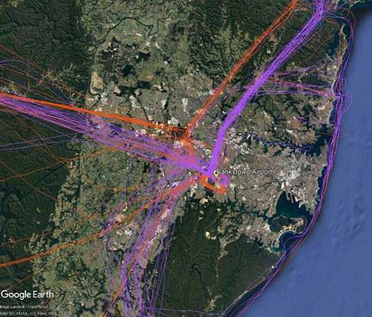
There are a number of routes around Sydney used by light aircraft and helicopters.
It is not mandatory that light aircraft and helicopters fly on these routes. As you will see from the images below which show the tracks of actual flights, some aircraft may fly the whole route but others may only fly part of it, joining or leaving it depending on their purpose or destination. Other aircraft may not use the routes at all.
These routes are mainly outside controlled airspace (“OCTA”), that is, aircraft are not being directed by air traffic control. Whenever they fly outside controlled airspace, pilots are following the rules of the air. Our booklet, Guide to our Operations, explains more about different types of airspace.
Pilots using these routes are usually flying under Visual Flight Rules, which means they navigate using landmarks that are easily seen from the air. This does not mean they must fly over each landmark; rather, they use each landmark to be sure of their position.
Most of these routes lead to and from Bankstown Airport, as shown in the images above and below.
To and from the south and south-west
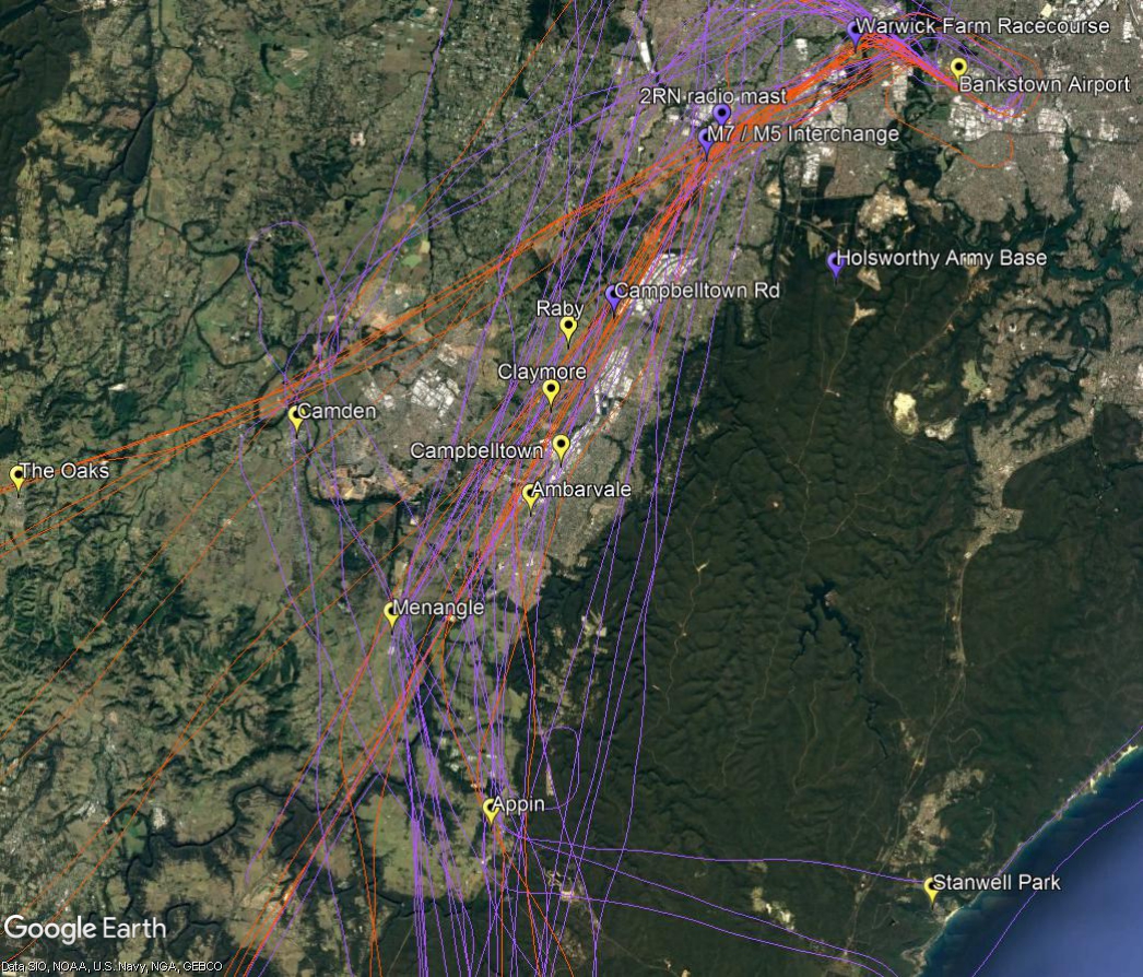
The image below shows actual aircraft tracks. Aircraft inbound to Bankstown Airport are coloured orange and outbound are purple.
From the south-west aircraft track towards Camden and then via the 2RN radio mast and the M7/M5 interchange and Warwick Farm Racecourse. From the south aircraft may track via Appin to Campbelltown Road and the 2RN mast.
If outbound to the south, aircraft will commence to climb to 2500 feet after passing the Liverpool to Parramatta railway line. The M7 motorway is a tracking feature for the turn to the south. Aircraft need to avoid restricted airspace around Holsworthy Army Base so will track towards Campbelltown and Appin. At Appin aircraft must be below 4500 feet to stay out of controlled airspace. If heading for the coast they will fly west of Appin then turn east towards Stanwell Park. By Stanwell Park aircraft must be at or below 2,500 feet to remain outside controlled airspace.
North-eastern suburbs of Sydney are overflown by aircraft travelling northwards to join the final approach to the parallel runways (flight path A3 in the image at right). This occurs when the parallel runways are being used in a southerly direction (“south flow”).
Aircraft on this flight path are being “vectored” by air traffic control. This means each aircraft is being given its own heading and altitude to allow it to intercept the final approach path, while maintaining safe separation from all the other aircraft around it.
These aircraft are well into their descents for landing and are continuing to descend under air traffic control instructions. This means that the altitude of each aircraft will vary according to how far it has left to fly before intercepting the final approach and the altitudes of other aircraft in the area. Aircraft will generally intercept the final approach at around 3,000 feet in altitude.
The image below shows the actual tracks of aircraft being vectored to join the final approach. The image shows the spread of aircraft that is created by the act of vectoring. This spread is deliberate as it is part of the noise sharing strategy set out in the Long Term Operating Plan for Sydney Airport.
Flight paths in Melbourne are designed to accommodate, and keep segregated, aircraft arriving from and departing to ports in different directions. While there are some different flight paths for jets and non-jets there are other flight paths that are used by both types of aircraft. The vast majority of aircraft at Melbourne Airport are medium to large jets.
Arrivals
Jet arrivals into Melbourne are generally aligned with the runway at least ten kilometres from the airport. From this point they will fly towards the runway in a straight line. This means that suburbs in line with the runways are overflown by arriving jets. Other suburbs may be overflown by aircraft proceeding towards the point at which they join the final approach and align with the runway.
Runways 16 and 27 have Instrument Landing Systems. This type of approach requires aircraft to be aligned with the runway at a distance of around twenty kilometres and height above the elevation of the runway of around 3000 feet when they begin their approach. Aircraft will descend steadily to the runway using the horizontal and vertical guidance provided by the system. A similar instrument approach known as Honeywell SmartPath is available on all runways.
There is no minimum altitude for aircraft in the process of landing. Aircraft will generally descend on a glide slope of three degrees.
Departures
Departure flight paths allow aircraft to maintain the runway heading for a short time until they are stabilised in flight, and then to turn towards the route that will take them to their destination.
The altitude of aircraft after departure will depend on factors such as the type of aircraft and its weight, how heavily laden it is with fuel and passengers, and the atmospheric conditions at the time. All these factors affect an aircraft’s climb rate. There is no regulated minimum altitude for an aircraft in the process of taking off.
Smart Tracking
A growing number of modern aircraft are now fitted with navigation systems that use satellite-assisted guidance which allow aircraft to fly with a higher degree of accuracy and more closely follow the same route as other aircraft. Airservices refers to these routes as ‘Smart Tracking’. Smart Tracking technology makes air travel safer, cleaner and more dependable. It also has the potential to improve noise outcomes for communities living close to airports.
While there are standard flight paths, aircraft may be directed off these at times for reasons including the need to avoid bad weather or for traffic management, that is, to ensure safe separation between aircraft. See WebTrak for further information about where aircraft fly.
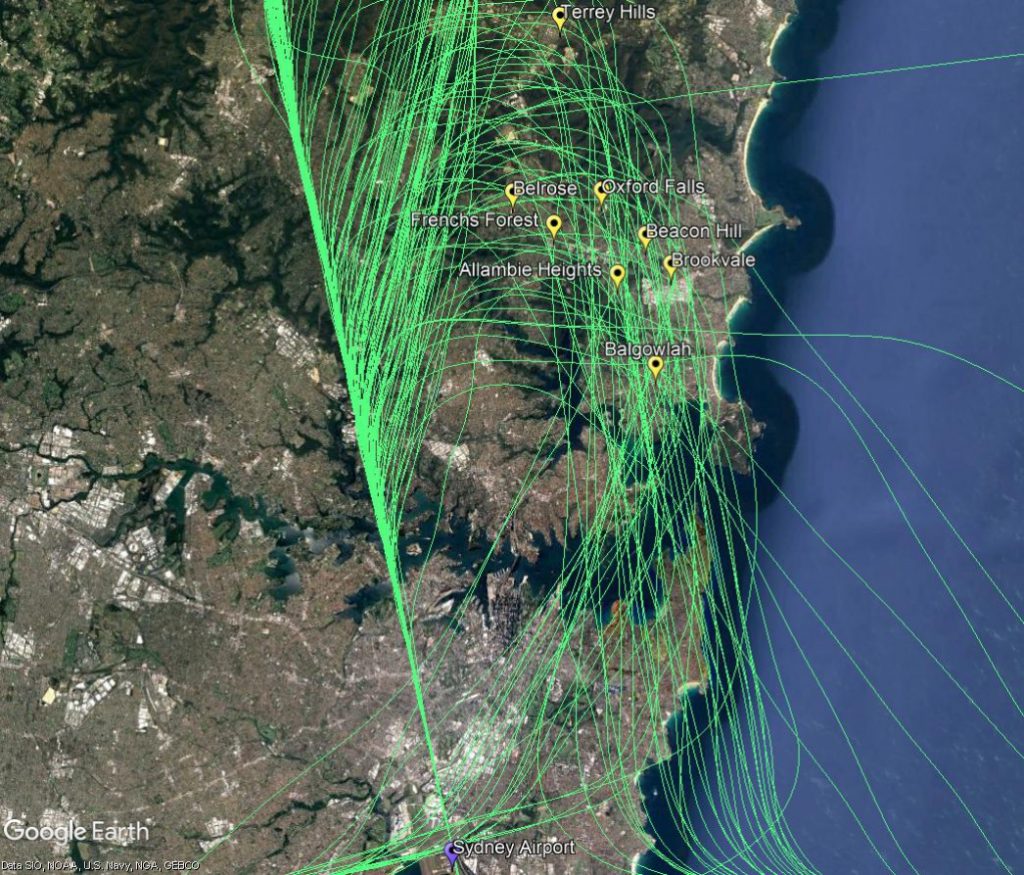
North-western suburbs of Sydney are overflown by aircraft travelling northwards to join the final approach to the parallel runways (flight path A2 in the image at right). This occurs when the parallel runways are being used in a southerly direction (“south flow”).
Aircraft on this flight path are being “vectored” by air traffic control. This means each aircraft is being given its own heading and altitude to allow it to intercept the final approach path, while maintaining safe separation from all the other aircraft around it.
These aircraft are well into their descents for landing and are continuing to descend under air traffic control instructions. This means that the altitude of each aircraft will vary according to how far it has left to fly before intercepting the final approach and the altitudes of other aircraft in the area. Aircraft will generally intercept the final approach at around 2500 to 3000 feet in altitude.
The image below shows the actual tracks of aircraft being vectored to join the final approach. The final approach path is the concentrated straight line at the bottom right of the image. This path leads directly to the runway. The image shows the spread of aircraft that is created by the act of vectoring. This spread is deliberate as it is part of the noise sharing strategy set out in the Long Term Operating Plan for Sydney Airport.
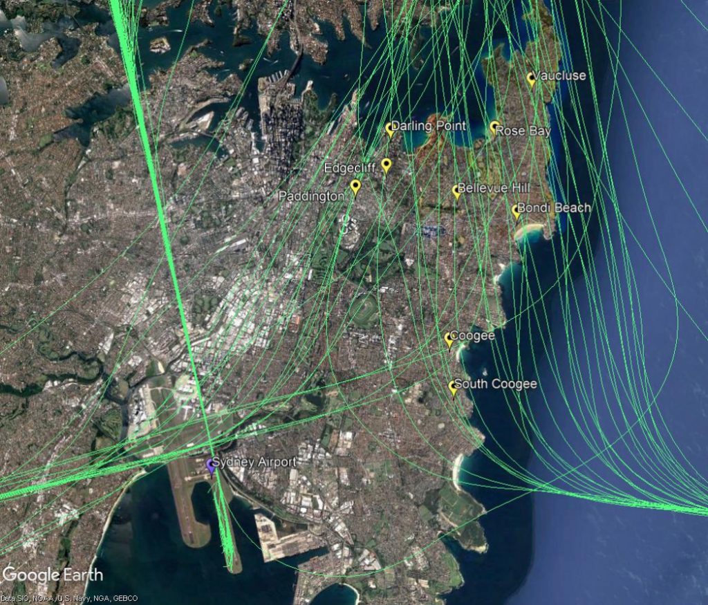
When the parallel runways are being used in a southerly direction (“south flow”), aircraft that arrive into Sydney from the south, east and west need to travel northwards to join the final approach path from the north. As they travel northwards some will pass over the eastern suburbs (labelled A3 in the image).
Aircraft travelling to join the final approach are being “vectored” by air traffic control. This means each aircraft is being given its own heading and altitude to allow it to intercept the final approach path (A1 in the image), while maintaining safe separation from all the other aircraft around it.
These aircraft are continuing to descend for landing under air traffic control instructions. This means that the altitude of each aircraft will vary according to how far it has left to fly before intercepting the final approach and the altitudes of other aircraft in the area. Aircraft will generally intercept the final approach at around 3,000 feet in altitude. When they are over the eastern suburbs they generally will be within the range of 6,000 to 7,500 feet in altitude.
The image below shows the actual tracks of aircraft being vectored over the eastern suburbs. These show the spread of aircraft that is created by the act of vectoring. This spread is deliberate as it is part of the noise sharing strategy set out in the Long Term Operating Plan for Sydney Airport.
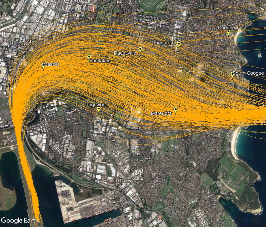
The eastern suburbs are affected by aircraft departing from the easternmost parallel runway (Runway 34 Right) and arriving to the east-west runway (Runway 25). Occasionally there will also be departures from the east-west runway (Runway 07) but this is relatively infrequent.
Departures from the parallel runway: north flow
When the parallel runways are being used in a northerly direction, (“north flow”), most aircraft departing the easternmost parallel runway turn to the east or north-east after take-off. Aircraft that turn east are bound for destinations to the east and south. They will pass over suburbs including Kingsford and Maroubra.
Aircraft using this flight path begin their turns when they reach 500 feet in altitude. As different types of aircraft have different climbing abilities, they will reach this altitude at different points after take-off and therefore begin their turns at different points in the air. This has the effect of creating a spread of aircraft. This spread can be seen in the image below which shows actual tracks of aircraft on this flight path.
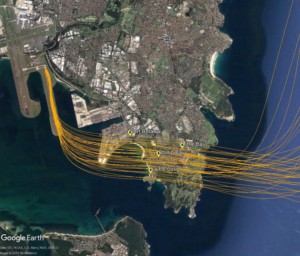
Departures from the parallel runway: south flow
When the parallel runways are being used in a southerly direction (“south flow”), non-jet aircraft that take off from the easternmost parallel runway turn left after departure. They turn immediately after take-off in order to ensure they remain separated from the faster jet traffic which proceeds through the heads.
Non-jets using this flight path are heading primarily to northern destinations such as Armidale, Taree, Coffs Harbour and Port Macquarie. After their initial eastward turn they will then turn north towards these destinations.
The image below shows the actual tracks of non-jet aircraft using this flight path.
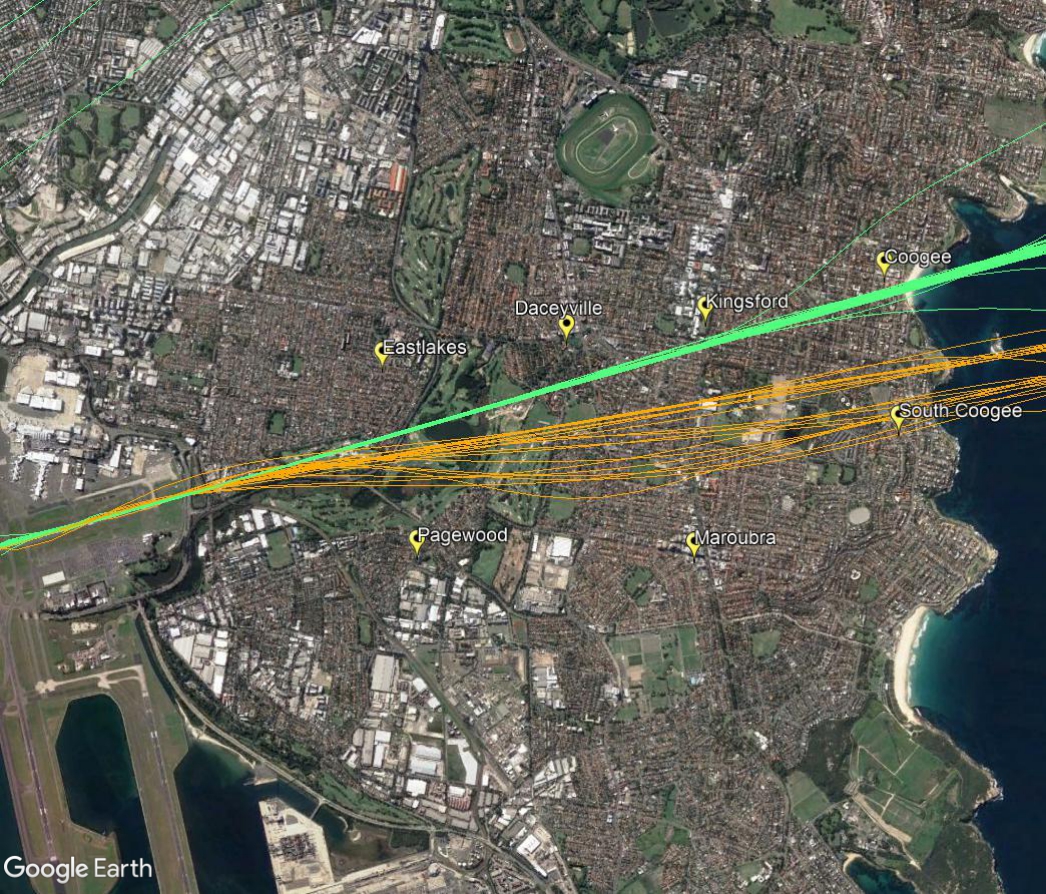
Arrivals to and departures from the east-west runway: west flow and east flow
In “west flow” the east-west runway is used for arrivals. Arriving aircraft must align with the runway from a considerable distance out from the airport, and fly straight in. This means that aircraft arriving to land during this runway configuration will always fly over suburbs such as Coogee, Randwick, Kingsford, Daceyville and Eastlakes.
Sydney’s seasonal wind patterns are such that the east-west runway tends to be used for arrivals more frequently in the cooler months that at other times of the year. At this time of year it is not unusual for Sydney to experience strong westerly winds. In these conditions there is often too much crosswind on the parallel runways, meaning that they cannot be safely used. When this occurs, all traffic may need to use the east-west runway for prolonged periods of time. This usually results in delays at the airport because the usual throughput of flights cannot be attained when using only one runway.
It is relatively unusual for aircraft to depart towards the east from the east-west runway, (“east flow”), but it does occur on occasion when the wind is a strong easterly. As explained above, in these conditions it may mean that the parallel runways cannot be used, resulting in all traffic departing towards the west.
The following image shows the actual tracks of arrivals to the east-west runway in green and departures in orange.
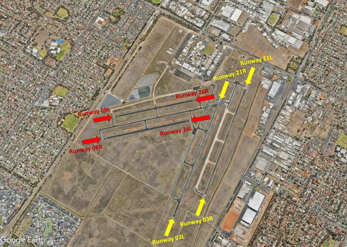
At Parafield Airport there are two sets of parallel runways. One set is orientated east to west (Runways 08 Left/26 Right and 08 Right/26 Left) and the other is orientated north to south (Runways 03 Left/21 Right – 03 Right/21 Left).
Each runway is referred to differently according to in which direction it is being used. For example, the north-south runways are referred to as Runway 03 Left and Right when used in a northerly direction and Runway 21 Left and Right when used in a southerly direction.
Runway numbering reflects the runways’ orientation and correlates with degrees on a compass. Runway 03 is 30 degrees magnetic.
The following video explains how runways are named and used.
Runway selection and seasonal winds
Runway selection is based on wind direction, weather conditions, traffic volume and other factors. See the Runway Selection fact sheet for more details. Aircraft primarily take-off and land into the wind for safety and performance reasons. Therefore, as the wind direction changes the runway in operation may also change depending on the strength of the wind.
This means that Adelaide’s seasonal wind patterns affect usage of the different runway directions. For example, Runways 03 Left and Right tend to be used more often in the cooler months when there are frequent winds with a northerly component. Runways 21 Left and Right tend to be used more frequently in the warmer months when the predominant wind direction tends to be southerly.
Noise abatement procedures
Noise abatement procedures are designed to help reduce the impact of aircraft noise on communities. While they are applied whenever it is possible to do so, their use is not mandatory and is subject to weather conditions and traffic requirements.
Circuit training is only allowed between specific hours. At night, circuit training can only be conducted from the north-south runways to the west. Outside of Tower hours the preferred runway is 03 Left/21 Right.
The majority of aircraft using Parafield Airport fly under Visual Flight Rules (VFR). There are designated routes for VFR aircraft to ensure that VFR traffic remains separate from aircraft flying under Instrument Flight Rules (IFR). It is not mandatory that VFR aircraft fly these routes, but many do, especially as they approach or depart airports.
These routes are outside controlled airspace (“OCTA”), that is, aircraft are not being directed by air traffic control. Whenever they fly outside controlled airspace, pilots are following the rules of the air. More information about airspace is found here.
VFR routes include defined entry and exit points to and from controlled airspace such as that around Parafield Airport. These are landmarks that are easily seen by the pilot from the air. These landmarks are highlighted in the images below, which also show the average percentage of arrivals or departures that use the route.
There is no minimum altitude for aircraft in the process of landing. Aircraft will generally descend on a glide slope of three degrees.
The altitude of aircraft after departure will depend on factors such as the type of aircraft and its weight, how heavily laden it is with fuel and passengers, and the atmospheric conditions at the time. All these factors affect an aircraft’s climb rate. There is no regulated minimum altitude for an aircraft in the process of taking off.
Arrival Routes
The VFR arrival route from the northwest begins at Dublin. Aircraft will be at or below 4500 feet at this point. The route crosses the coast at River Mouth by which time aircraft must not be above 1500 feet. The route then tracks over water to the entry point at Outer Harbor.
From the east aircraft track via Warren Reservoir where they will be below 2500 feet to Little Para Reservoir Dam Wall entry point where they need to be 1500 feet.
From the south the VFR route begins at Tailem Bend and tracks via Strathalbyn where aircraft will be below 4500 feet. It then proceeds to Port Noarlunga where aircraft will stay below 2500 feet. From there aircraft will track up the coast to the Marino Lighthouse. Aircraft will now be at 1500 feet as they fly past the Mitsubishi Car Plant to the Waite Campus of Adelaide University, and then to Hope Valley Reservoir entry point.
Outer Harbor and Little Para Reservoir Dam Wall are the most used entry points.
Departure routes
The VFR exit points are Port Adelaide, St Kilda, Para Substation and Hope Valley Reservoir. St Kilda and Para Substation are the most-used exit points.
Aircraft departing to the north-west will maintain 1000 feet until reaching St Kilda to separate them from arriving aircraft at Outer Harbor which are at 1500 feet. To stay out of controlled airspace, aircraft will avoid climbing above 1000 feet until north of St Kilda. While tracking towards Dublin aircraft will climb to 2500 feet until past Middle Beach where they can climb to at or below 4500 feet.
Departures to the east are via Para Substation, past the GMH complex. Aircraft will maintain 1000 feet until clear of traffic and then climb to 1500 feet. Once clear of the Parafield Control Zone they will climb to not above 2500 feet and track to South Para Reservoir.
Departures to the south may be cleared by air traffic control on the Hope Valley Reservoir route from Waite Campus at Adelaide University to Marino Lighthouse. Alternatively they may be directed to depart via St Kilda from where further clearance to head south is required.
Training area
A designated training area exists to the north-west of the airport and to the west and north-west of the RAAF Edinburgh Base. Once pilots progress past the circuit training stage of their courses they will begin flying to and around the training area.
The training area is outside controlled airspace. It extends from St Kilda, which is approximately 10 kilometres west-north-west of the airport, to Long Plains, which is a further 45 kilometres to the north-west of St Kilda. The training area is to the west of this line and extends to 9 kilometres off the coast. It is ‘wedge-shaped’ because it is located in-between military restricted airspace to the west and north and the RAAF Edinburgh Base Control Zone to the east.
From the St Kilda area to just south of Middle Beach the training area exists between the surface (“SFC”) and 2500 feet. North to Long Plains the area extends between the surface and 4500 feet. These levels keep the aircraft below controlled airspace; therefore aircraft do not need a clearance from air traffic control to operate in the training area.
Aircraft wishing to track to the training area from Parafield Airport must remain south of the Bolivar strobe light and west of St Kilda to remain outside controlled airspace. The north- and southbound VFR routes (described above) transit the area.
Activities that may occur inside the training area include parachute operations and light aircraft movements at Lower Light aircraft landing area, as well as training flights by light aircraft in and around the area and aircraft transiting on the north and southbound VFR routes. There can be increased traffic volumes in the area due to use by flight training companies from Parafield Airport and because all aircraft are confined to a relatively small area due to the surrounding military airspace including RAAF Base Edinburgh.
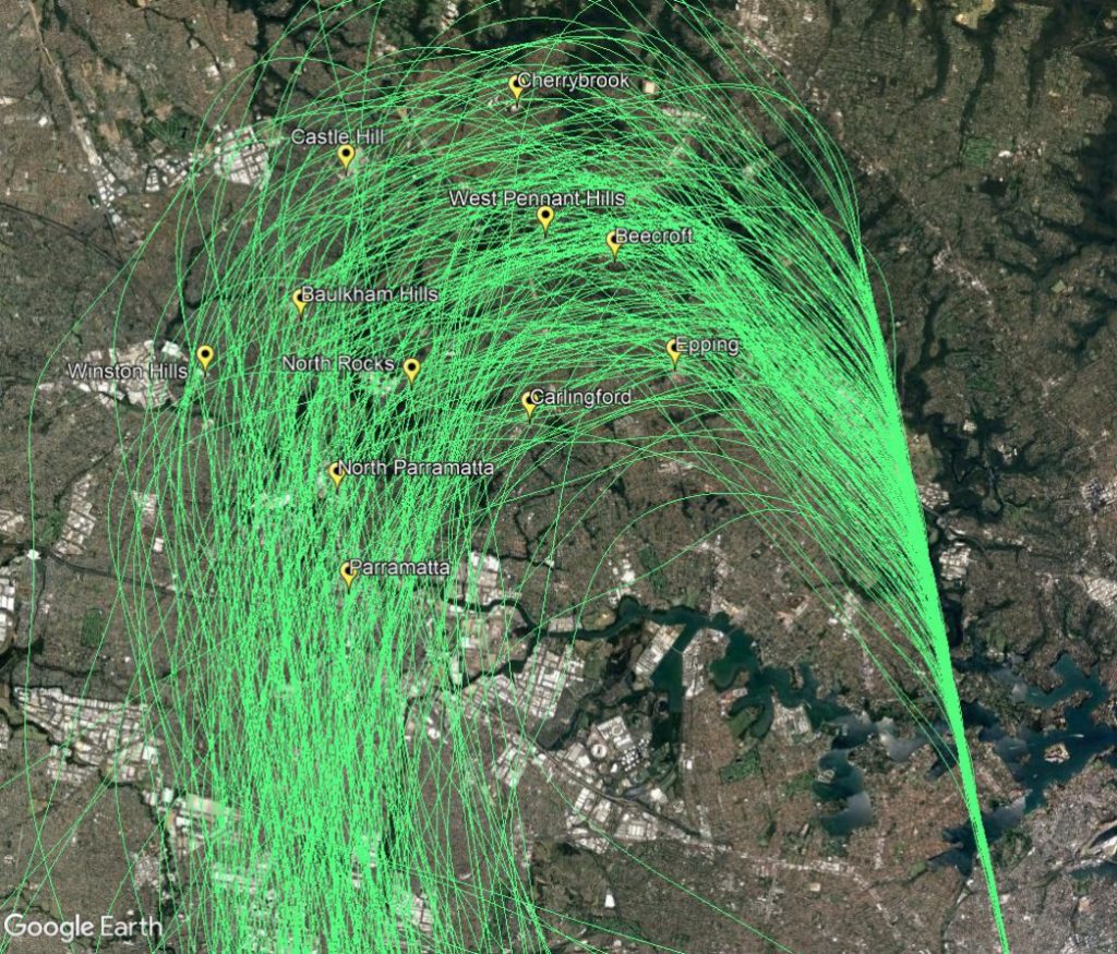
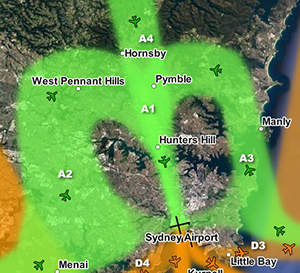
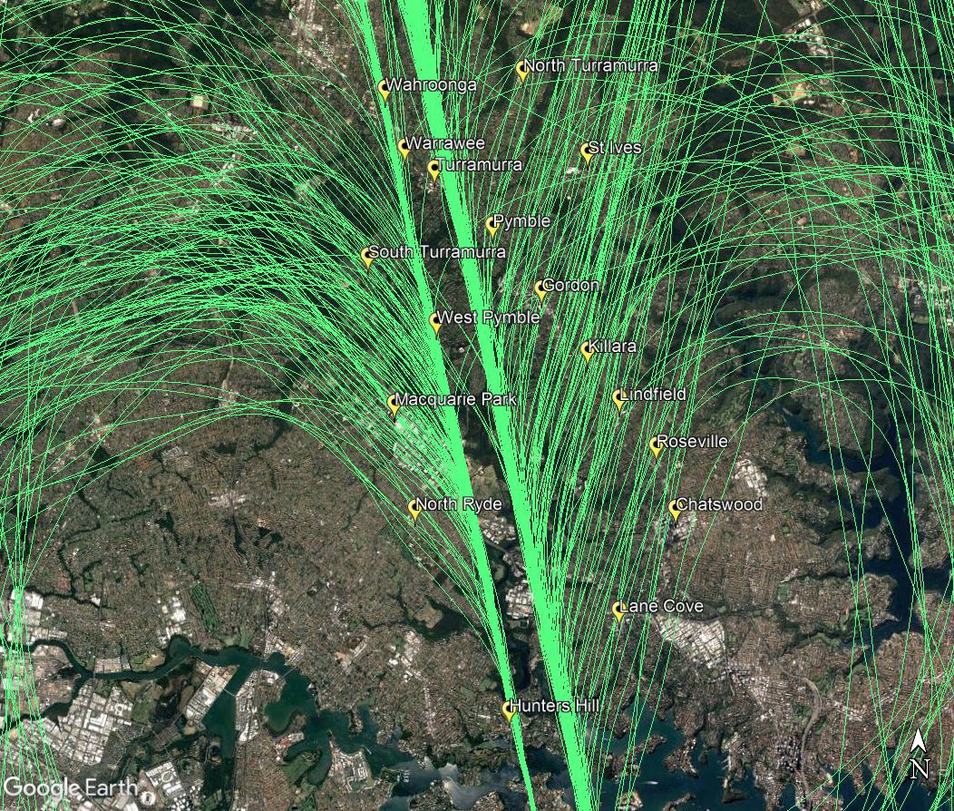
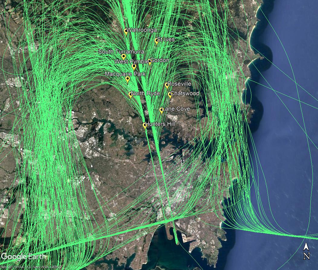
Suburbs to the north of the airport are affected by aircraft arriving to the parallel runways when they are being used in a southerly direction, (“south flow”) as shown by the flight paths labelled A1, A2, A3 and A4 in the image, right.
Arriving aircraft must align with the runway from a considerable distance out from the airport, and fly straight in. The aircraft that fly over the northern suburbs are either travelling to align with the runway and join the final approach (flight paths A2, A3 and A4), or are already lined up with the runway and on the final approach (A1).
Aircraft travelling to join the final approach are being “vectored” by air traffic control. This means each aircraft is being given its own heading and altitude to allow it to intercept the final approach path, while maintaining safe separation from all the other aircraft around it.
These aircraft are well into their descents for landing and are continuing to descend under air traffic control instructions. This means that the altitude of each aircraft will vary according to how far it has left to fly before intercepting the final approach and the altitudes of other aircraft in the area. Aircraft will generally intercept the final approach at around 3000 feet in altitude.
While it might seem like the northern suburbs are a long way from the airport, in aviation terms they are relatively close. For example, the flying time to the runway from Wahroonga is less than five minutes, and less than three minutes from Hunters Hill.
The images below show the actual tracks of aircraft arriving over the northern suburbs. These show the spread of aircraft that is created by the act of vectoring. This spread is deliberate as it is part of the noise sharing strategy set out in the Long Term Operating Plan for Sydney Airport.
The first image is zoomed in on your area:
The next image is zoomed out to show the approach all the way to the runways.