Essendon Airport Flight Paths

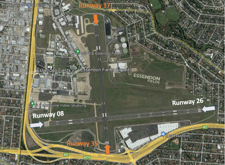
There are flight paths in and out of Essendon Airport for Instrument Flight Rules (IFR) aircraft and Visual Flight Rules (VFR) aircraft as explained below.

Because Melbourne Airport and Essendon Airport are in very close proximity, traffic at Essendon Airport sometimes needs to be managed in irregular ways to ensure that separation is maintained with Melbourne Airport traffic. Therefore at times you may observe aircraft flying in unusual ways.

A curfew that restricts both aircraft type and usage between the hours of 11pm and 6am applies. Certain classes of aircraft are permitted to operate during the curfew, including emergency services. More detail on curfew restrictions and dispensations is available on the Department of Infrastructure, Transport, Regional Development and Communications website.

Aircraft operating in Australia are required to meet noise standards imposed through the Air Navigation (Aircraft Noise) Regulations 201

IFR Routes

Arrivals

Aircraft will approach Essendon Airport from all directions before they join the final approach path. Most arriving IFR aircraft will use standard arrival paths but some may be “radar vectored” by Melbourne air traffic control to intercept the final approach, that is, some aircraft may be given individual headings.

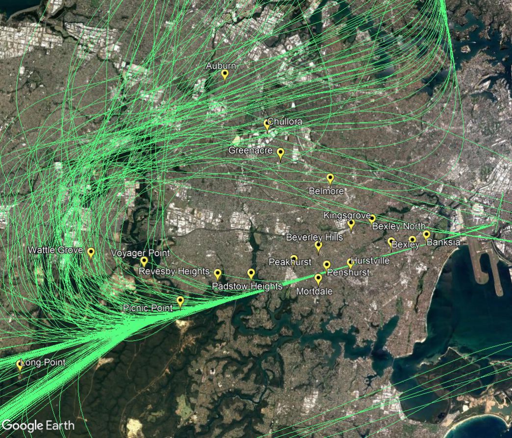
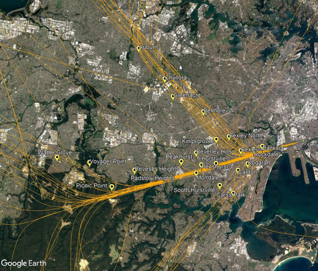
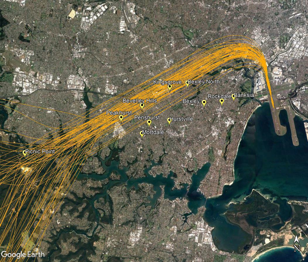
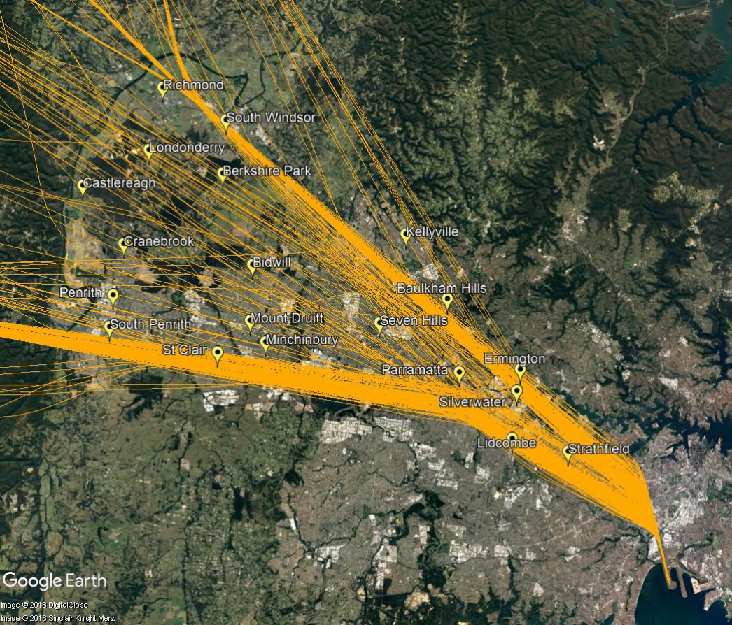
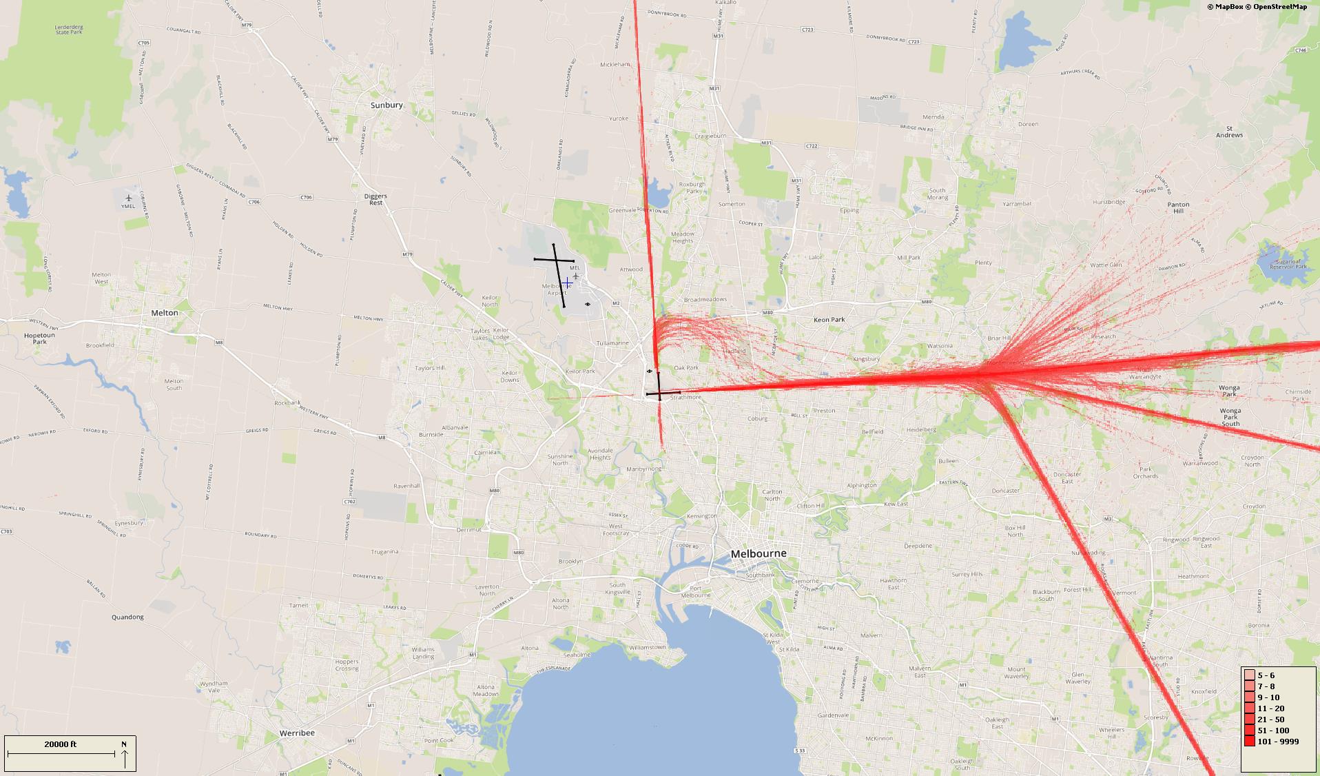
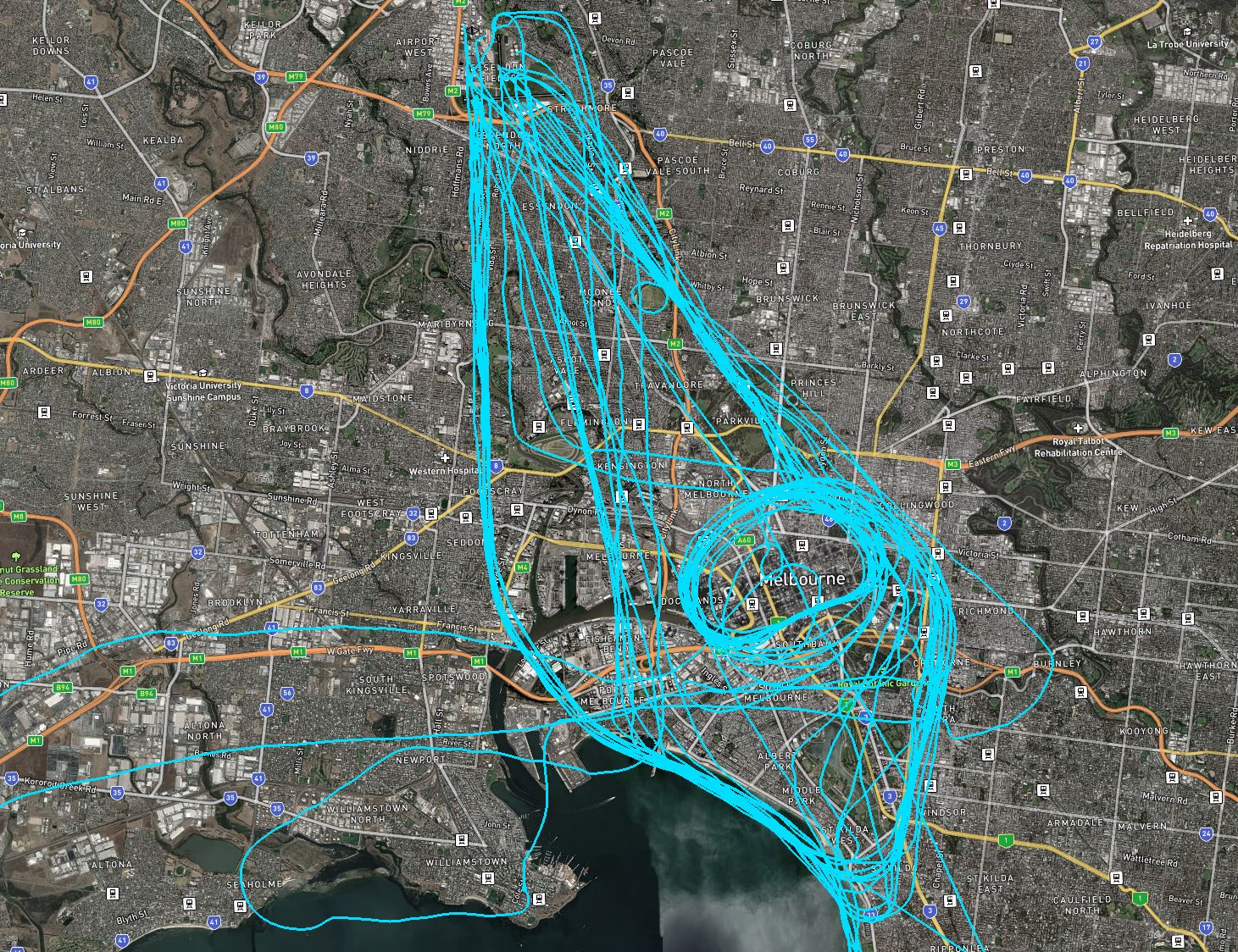
During inclement weather aircraft will usually make instrument approaches, which require the aircraft to be aligned with the runway in use 18 kilometres or more out from the airport as can be seen in the image of arrival flight paths below.

There is no minimum altitude for aircraft in the process of landing. Aircraft will generally descend on a glide slope of three degrees.

Departures

Aircraft departing Essendon Airport must be kept separated from aircraft departing and arriving Melbourne Airport. In most cases Essendon departures will be turned away from Melbourne Airport after take-off. Some aircraft may be directed to turn off the runway heading sooner than others. This usually occurs for traffic management reasons to ensure that safe separation is maintained between aircraft.

The altitude of aircraft after departure will depend on factors such as the type of aircraft and its weight, how heavily laden it is with fuel and passengers, and the atmospheric conditions at the time. All these factors affect an aircraft’s climb rate. There is no regulated minimum altitude for an aircraft in the process of taking off.
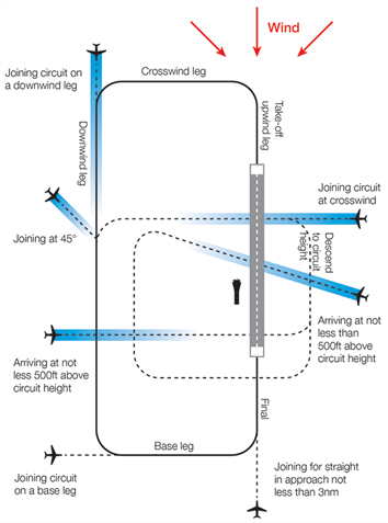
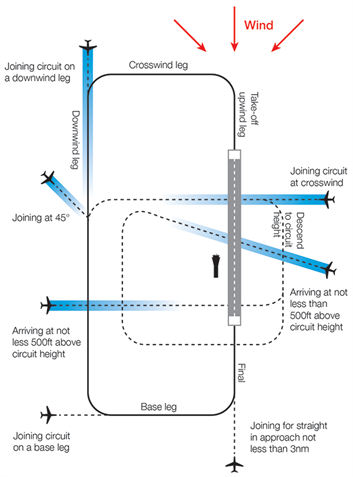
VFR routes

There are designated routes for Visual flight Rules (VFR) aircraft to ensure that this traffic remains separate from aircraft flying under Instrument Flight Rules such as jets and most commercial aircraft. It is not mandatory that VFR aircraft fly these routes, but many do, especially as they approach or depart airports.

These routes are mainly outside controlled airspace (“OCTA”), that is, aircraft are not being directed by air traffic control. Whenever they fly outside controlled airspace, pilots are following the rules of the air. More information about airspace is found here.

VFR routes include defined entry and exit points to and from controlled airspace. These are landmarks that are easily seen by the pilot from the air.

Aircraft inbound from the north may track via Craigieburn. Those from the north-east may track via Yan Yean Reservoir and Epping. When inbound from the east aircraft may track via Doncaster Shopping Centre and then either north or south of the airport or direct to the airport depending on which runway is in use.

Aircraft inbound from the south-east may track via major visual tracking points such as Albert Park and Station Pier or Westgate Bridge and then either via Moonee Valley Racecourse or direct to the airport.

From the south-west and west some aircraft will track coastal and via Laverton Bureau of Meteorological Tower, then get a clearance to track via Station Pier or Westgate Bridge and then via Moonee Valley Racecourse or direct to the airport.

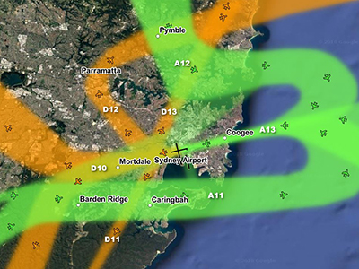
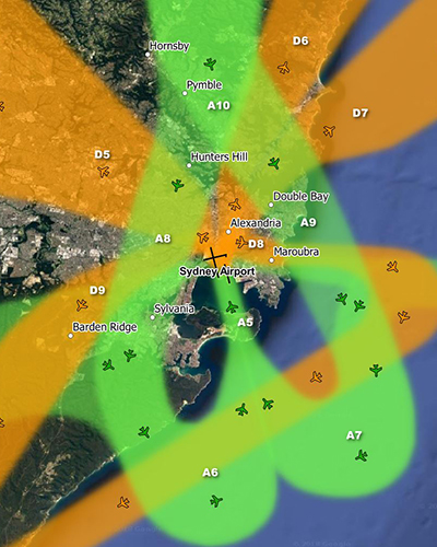
The image below shows VFR and IFR arrival routes and the average percentage each VFR route is used.

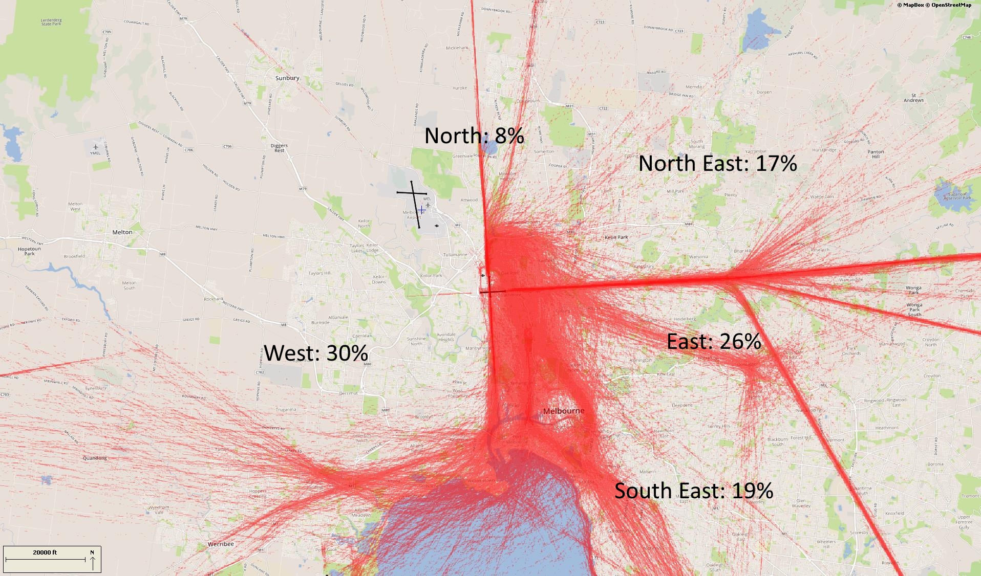
Outbound VFR aircraft will be cleared via one of the visual tracking points towards their destination.

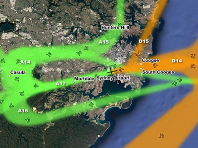
The image below shows VFR departure routes and the average percentage each is used.

Coastal route

The coastal route runs from Carrum to the south of Moorabbin Airport and around to Altona South. This allows aircraft to track around the city and the Bay while keeping outside controlled airspace and therefore not needing a clearance from air traffic control. A large number of light aircraft use this route.

Training Area

Aircraft may use the coastal route to access the training area south-east of Moorabbin Airport, or the training area near Point Cook.

Scenic helicopter routes

A number of helicopter and fixed wing operators conduct scenic flights from Essendon Airport and Moorabbin Airport. The main scenic route sees the aircraft flying an orbit over the area around Docklands, Eureka Tower, Rod Laver Arena, the MCG and AAMI Stadium, Exhibition Building, and Eureka Skydeck 88.

Other scenic flights head out of Essendon over Flemington Racecourse towards Port Philip Bay. This is followed by a coastal flight and then an orbit of the Docklands / MCG area. As shown in the image, above, routes can vary.

Flights are conducted at 1000 feet altitude over residential areas and 500 feet over water. Operators may choose to fly higher however in the area immediately around Essendon Airport and over the CBD passenger aircraft operate in the airspace directly above which limits the level scenic flights can ascend to.

Sydney Airport flight paths – east and west flow

Suburbs to the immediate west of Sydney Airport are affected by aircraft arriving to (“east flow”) and departing from (“west flow”) the east-west runway.

Below: east flow (left) and west flow (right)
East flow West flow

Sydney’s seasonal wind patterns mean that you are more likely to experience arrivals in the warmer months and departures in the cooler months. This is because aircraft need to take off and land into the wind. You are also more likely to experience traffic in non-peak periods when the east-west runway is used whenever possible for noise sharing purposes. Non-peak periods are generally:

  • 6:00 – 7:00am,
  • 11:00 – 3:00pm, and
  • after 8:00pm.

These times may vary, however. There will also be days when the wind conditions make use of the two north-south parallel runways impossible, and on such days you are likely to experience heavy levels of traffic for prolonged periods.

Arrivals – east flow

Arriving aircraft must align with the runway from a considerable distance out from the airport, and fly straight in. This means that aircraft arriving to land on the east-west runway will always fly over suburbs such as Picnic Point, Penshurst, Hurstville, Bexley and Rockdale. The following image shows actual tracks of arriving aircraft.

Arrivals

Departures – west flow

Aircraft departing towards the west will turn to their heading when they reach 1,500 feet (for jets) or 800 feet (for non-jets). As different types of aircraft have different climbing abilities, they will reach this altitude at different points after take-off and therefore begin their turns at different points in the air. This has the effect of creating a spread of aircraft as can be seen in the image below.

If the aircraft is proceeding to destinations to the west such as Perth or south such as Melbourne it will maintain the runway heading for longer before turning.The following image shows actual tracks of departing aircraft.

Departures

Departures – north flow

When aircraft are departing from the westernmost of the parallel runways, non-jets (turbo-prop aircraft) that are heading for southerly or westerly destinations will turn left after departure when they reach the altitude of 600 feet. This will create a spread of aircraft, taking them over suburbs such as Kingsgrove, Beverley Hills and Peakhurst. This is illustrated in the track image below.

Non jet departures

Essendon Airport Runways

Essendon Airport has two intersecting runways, one oriented north-south (Runway 17/35) and one east-west (Runway 08/26).

Each runway is referred to differently according to in which direction it is being used. For example, the north-south runway is referred to as Runway 35 when used in a northerly direction and Runway 17 when used in a southerly direction.

Runway numbering reflects the runways’ orientation and correlates with degrees on a compass. Runway 35 is 350 degrees magnetic.

The following video explains how runways are named and used.

Runway selection and seasonal winds

Runway selection is based on wind direction, weather conditions, traffic volume and other factors. See the Runway Selection page for more details. Aircraft primarily take-off and land into the wind for safety and performance reasons. Therefore, as the wind direction changes the runway in operation may also change depending on the strength of the wind.

This means that Melbourne’s seasonal wind patterns affect usage of the different runway directions. For example, Runways 35 tends to be used more often in the cooler months when there are frequent winds with a northerly component. Runway 17 tend to be used more frequently in the warmer months when the predominant wind direction tends to be southerly. Often the wind will also have a westerly component, such as a north westerly or south westerly, and for this reason Runway 26 is used frequently throughout the year.

Noise abatement procedures

A curfew that restricts both aircraft type and usage between the hours of 11pm and 6am applies. Certain classes of aircraft are permitted to operate during the curfew, including emergency services. More detail on curfew restrictions and dispensations is available on the Department of Infrastructure, Transport, Regional Development and Communications website.

Noise abatement procedures are designed to help reduce the impact of aircraft noise on communities. While they are applied whenever it is possible to do so, their use is not mandatory and is subject to weather conditions and traffic requirements.

The Essendon noise abatement procedures set out preferred runways at different times.

From 6:00 am to 11:00pm the preferred runways are:

  • for landing: Runway 26 or 17 (equally preferred), followed by Runway 35 and lastly Runway 08
  • for take-off: Runways 26 or 35 (equal), followed by Runway 17 and lastly Runway 08

From 11:00pm to 6:00am the preferred runways are:

  • for landing: Runway 17, followed by Runway 26, then 35, then 08
  • for take-off: Runway 35, followed by Runway 26, then 17, then 08

Moorabbin Airport Runways

At Moorabbin Airport there are two sets of parallel runways. One set is orientated north to south (Runways 17 Left/35 Right and 17 Right/35 Left) and the other is orientated north-west to south-east (Runways 31 Left/13 Right and 13 Right/31 Left).

Each runway is referred to differently according to in which direction it is being used. For example, the north-south runways are referred to as Runway 35 Left and Right when used in a northerly direction and Runway 17 Left and Right when used in a southerly direction.

Runway numbering reflects the runways’ orientation and correlates with degrees on a compass. Runway 35 is 350 degrees magnetic.

The following video explains how runways are named and used.

Runway selection and seasonal winds

Runway selection is based on wind direction, weather conditions, traffic volume and other factors. See the Runway Selection page for more details. Aircraft primarily take-off and land into the wind for safety and performance reasons. Therefore, as the wind direction changes the runway in operation may also change depending on the strength of the wind.

This means that Melbourne’s seasonal wind patterns affect usage of the different runway directions. For example, Runways 35 Left and Right tend to be used more often in the cooler months when there are frequent winds with a northerly component. Runways 17 Left and Right tend to be used more frequently in the warmer months when the predominant wind direction tends to be southerly.

Noise abatement procedures

Noise abatement procedures are designed to help reduce the impact of aircraft noise on communities. While they are applied whenever it is possible to do so, their use is not mandatory and is subject to weather conditions and traffic requirements.

Under the noise abatement procedures, circuit training is only allowed between specific hours.

The preferred runway for use is Runway 35. The second choices are Runways 17, 13 and 31 equally. No circuits are to be conducted on Runway 04/22 which is not available unless operationally required, for example, because the wind conditions make other runways unusable.

For Runway 17 Right, departures are not permitted before 9:00am, jet departures are not permitted, and departing aircraft should maintain the runway heading until south of Woodlands Golf Course. Some aircraft types are not permitted to use this runway unless no other is available.

Departures from Runway 31 Left should maintain the runway heading until over Kingston Centre.

Cambridge Airport Flight Paths

Cambridge Airport has a range of General Aviation (light aircraft) operations.

To learn more about Cambridge Airport operations, take a look at our Cambridge Airport circuits page.

The illustration below shows how light aircraft typically operate at Cambridge Airport. These aircraft usually fly using visual flight rules, where the pilot uses visual references to the ground or water rather than flying on a published instrument flight path. This means we see a broad area where light aircraft may fly.

The animation is indicative only and provided for information purposes, on occasions flights may leave these general areas from time-to-time.

Hobart Airport Runway

Hobart Airport has one 2.7 kilometre long runway (aligned north-west/south-east) that operates in both directions, depending on the wind at the time of take-off or landing.

The following video explains how runways are named and used.

The runway at Hobart Airport is called Runway 12/30.

Runway numbering reflects the runways’ orientation and correlates with degrees on a compass. Runway 30 is 300 degrees while Runway 12 is at 120 degrees.

Operations in a south-easterly direction use Runway 12, and operations in a north-westerly direction use Runway 30.

The image below shows the runway at Hobart, with:

  • The yellow arrow pointing to Runway 12
  • The white arrow pointing to Runway 30.

To learn more about the flight paths at Hobart Airport, take a look at our Hobart Airport Flight Paths page.

Hobart Airport Flight Paths

Hobart Airport has a number of flight paths from its runway.

To learn more about the runway at Hobart Airport, take a look at our Hobart Airport Runway page.

The illustration below shows how jet and non-jet (turbo-prop) aircraft typically operate at Hobart Airport on the published instrument arrival and departure flight paths.

The animation is indicative only and provided for information purposes, on occasions flights may leave these general areas from time-to-time.

Sydney Airport departures

North flow
Jet and turbo-prop aircraft that are heading for destinations to the west, north and north-west will fly over or near your area after departure from Sydney Airport. This corridor is labelled D5 in the image, right. These flights are bound for destinations such as Dubbo, Perth, Adelaide, Darwin, Broome, Singapore, Kuala Lumpur, Dubai, Abu Dhabi, Hong Kong and Shanghai.

As shown in the image below of actual tracks of departing aircraft, there are two concentrated flight paths. One tracks towards Richmond, passing over suburbs such as Ermington, Baulkham Hills and South Windsor. The other tracks towards Katoomba over Parramatta, St Clair and South Penrith.

Aircraft will also fly on either side of these two flight paths. This traffic is being individually directed by air traffic control in order to manage the volume of aircraft in the airspace. For example, a slower aircraft may be moved off the main flight path in order to take it out of the way of a faster jet behind it.

Altitudes over your area will vary according to factors such as the weight of the aircraft and how heavily laden it is. For example, long-haul aircraft departing for Dubai will be much heavier than smaller aircraft heading to Perth or Adelaide due to fuel load and aircraft size and therefore they will climb more slowly. The maximum take-off weight (MTOW) for an Airbus A380 is 560,000kg and for a Boeing B747 it is 396,890kg. The MTOW of an A320 is 73,500kg and for an A330 it is 230,000kg.

While differences in weight will affect an aircraft’s climb rate, even the atmospheric conditions at the time can play a part in how quickly an aircraft can climb. When the weather is warm, the air is less dense and therefore there is less lift and the aircraft climbs more slowly.

Generally, the average altitude of an A380 over Parramatta is around 5,500 feet and over South Penrith around 9,000 feet. In contrast the average for the smaller A320 or B737 over Parramatta is around 6500 feet and over South Penrith around 14,000 feet.

Over Baulkham Hills an A380’s average altitude is around 7000 feet and over Richmond around 11,500 feet. An A320/B737 would be at an average of around 8,500 feet over Baulkham Hills and 15,000 feet over Richmond.

This image shows the tracks of departing aircraft:

Departures

Cambridge Airport circuits

The majority of General Aviation (light aircraft) operations are conducted to or from Cambridge Aerodrome.

Air traffic control do not provide runway separation or information on traffic operating on the manoeuvring area to Cambridge Aerodrome, however, during tower hours (5:50am to 10:10pm) Hobart Tower provides information for Cambridge aerodrome traffic.

Rotor-Lift Aviation also conduct circuit training at Hobart Airport and winch training at Seven Mile Beach and at Pawleena. 

To learn more about Cambridge Airport operations, take a look at our Cambridge Airport Flight Paths page.

Where are the circuits at Hobart?

By day most of the circuit training is conducted on the west of the aerodrome over the suburbs of Cambridge, Mount Rumney and Acton Park, while at night it is done to the eastern side of the aerodrome over Hobart airport and Barilla Bay. Regular use is also made of the Ralphs Bay Flying Training area adjacent to the suburbs south of Lauderdale.

General aviation traffic operating beyond the Cambridge circuit are not constrained to set routes however geographical limitations, preferred operating routes and the need to segregate these operations from jet traffic means that there tends to be a higher concentration of aircraft operating to and from the Hobart City area to the west and to from the Midway Point/ Sorrell areas to the East (and beyond).

What is circuit training?

Circuit training is the first stage of practical pilot training focused on take-offs and landings. It involves the pilot making approaches to the runway or helipad, touching down and then applying power to take off again. This is undertaken in accordance with Civil Aviation Safety Authority (CASA) Regulations which are consistent with international practices.

How are circuits flown?

A training circuit consists of five legs – take-off, crosswind, downwind, base and final approach to the runway.

Aircraft take off into the wind, climb to 500 feet and then turn onto the crosswind leg. They continue to ascend to 1000 feet and turn onto the downwind leg. Having turned onto the base leg the descent commences. After turning onto the final leg and lining up with the runway the aircraft will touch down and take off again.

For left-hand circuits, the pilot turns left after take-off and flies anticlockwise. For right-hand circuits, the pilot turns right and flies in a clockwise direction.

A simplified representation of a left-hand circuit is shown above

Cairns Scenic Flights and Circuit Training

Scenic flights

Light aircraft and helicopters conduct scenic flights in the Cairns region. Light aircraft operate from Cairns Airport and helicopters operate from both Cairns Airport and the Cairns Esplanade Helipad. The scenic flights are mainly to the Great Barrier Reef, with immediate turns or tracking towards the reef on departure. On return, light aircraft may require a long or short approach to the runway, depending on the conditions. Helicopters will either fly directly back to the helipad or may continue the scenic flight inland taking in sights such as the Kuranda Scenic Rail, Skyrail Rainforest Cableway, the Barron Falls and Barron River.

Circuit Training

Light aircraft and helicopters conduct pilot training at Cairns Airport including circuit training.

Circuit training is the first stage of practical pilot training focused on take-offs and landings. It involves the pilot making approaches to the runway or helipad, touching down and then applying power to take off again. This is undertaken in accordance with Civil Aviation Safety Authority (CASA) Regulations which are consistent with international practices.

How circuits are conducted

A training circuit consists of five legs – take-off, crosswind, downwind, base and final approach to the runway.

Aircraft take off into the wind, climb to 500 feet and then turn onto the crosswind leg. They continue to ascend to 1000 feet and turn onto the downwind leg. Having turned onto the base leg the descent commences. After turning onto the final leg and lining up with the runway the aircraft will touch down and take off again.

Helicopters circuit inside the fixed wing circuit at a lower altitude.

Aircraft usually conduct left hand circuits however at Cairns Airport, for noise abatement, when the runway is used in a northerly direction the aircraft will make a right turn so most of the circuit is over water.

A simplified representation of a left-hand circuit is shown at right. The take off and final stage of the circuit is flown into the wind, as this is the safest way for an aircraft to operate. The aircraft symbols and dotted lines indicate recommended ways for an aircraft to join the circuit pattern. Click the image to enlarge it, and use your browser “Back” button to return to this page.

Between 10.00 pm and 7.00 am, circuit training by jet aircraft (and other aircraft exceeding 5700 kilograms maximum take-off weight) is not permitted.

More information about circuit training is found here.

Flight tracks of scenic flights and circuit training is found in the Cairns Airport Flight Paths page.