How is airspace used?

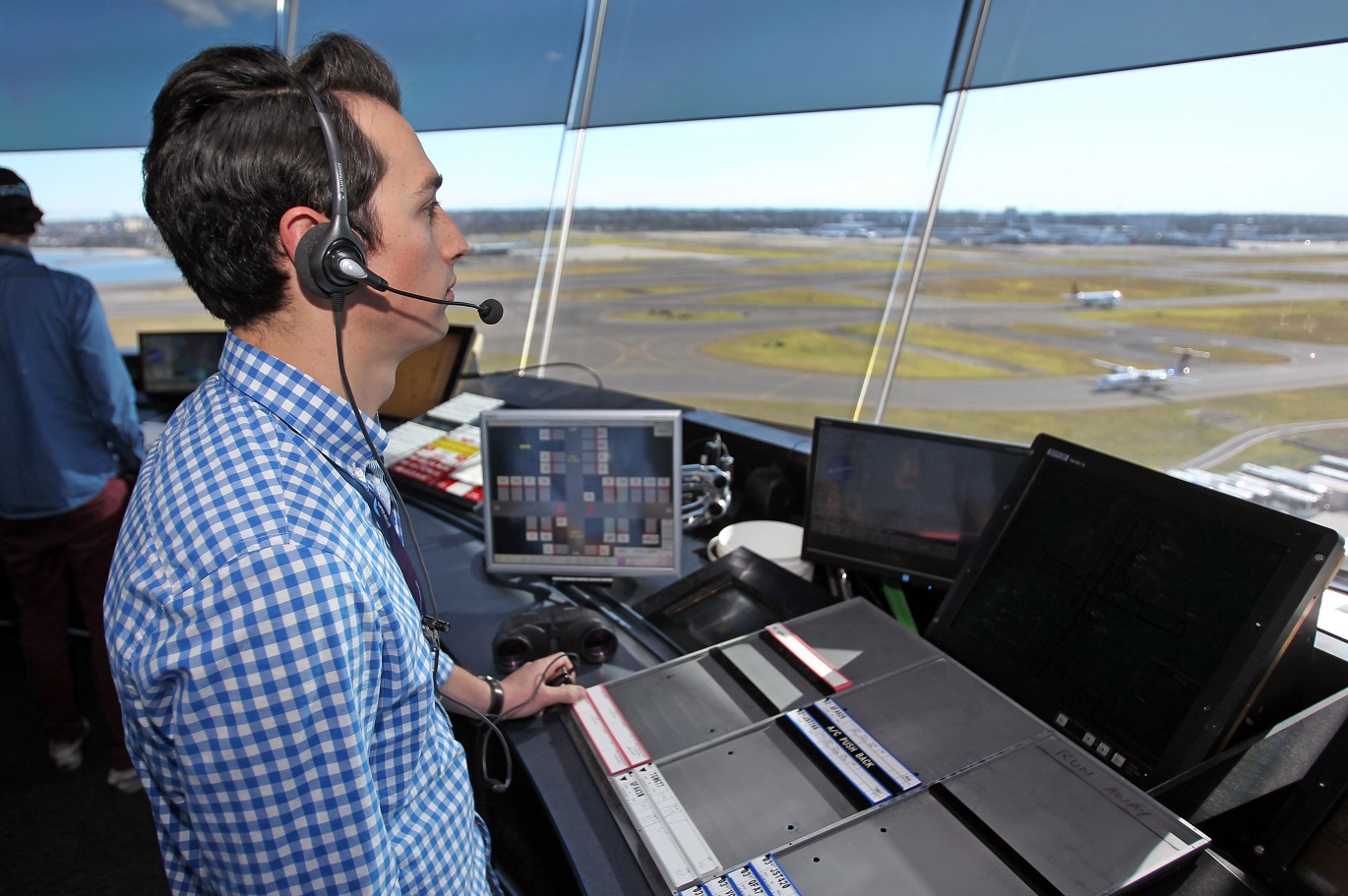
Each year we manage domestic and international air traffic operations for over 140 million passengers on more than four million aircraft movements in a region covering 11 per cent of the world’s surface. The following video shows what 24 hours of operations looks like:

Controlled and uncontrolled airspace

Airspace is designated as either:

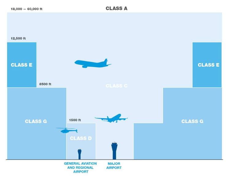
  • Controlled airspace which is actively managed by air traffic controllers and is broken up into a number of different classes or classifications. To enter controlled airspace, an aircraft must first gain a clearance from air traffic control.
  • Uncontrolled airspace which requires no clearance (or supervision by air traffic control) to operate. The large majority of light aircraft and helicopters operate outside or underneath controlled airspace (for example, aircraft that operate at low levels over Sydney Harbour).

Terminal Airspace

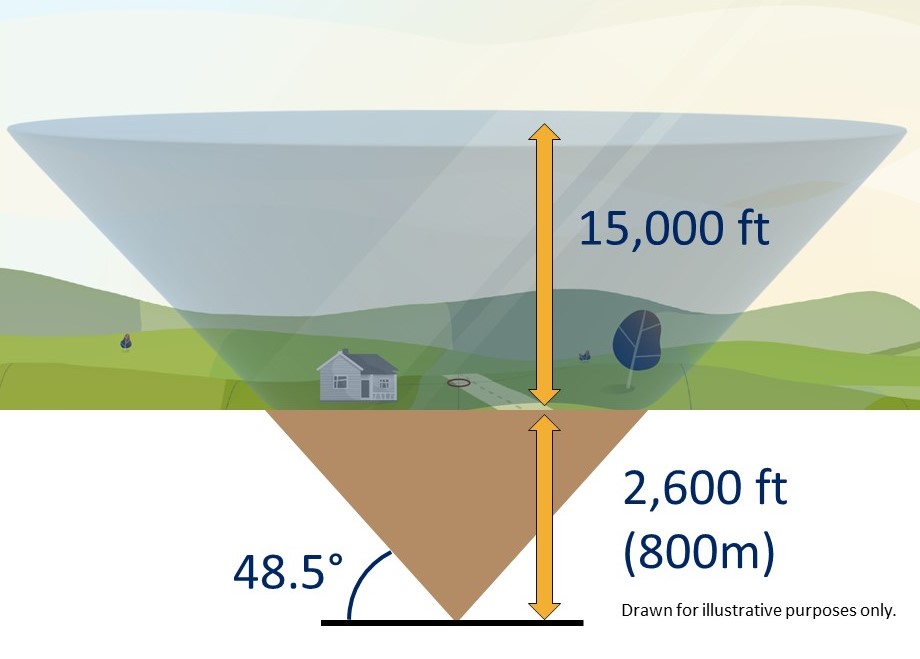
Terminal airspace is the controlled airspace surrounding a major airport, generally within a 30–50 nautical miles (55–90 kilometres) radius. In the case of some major airports, this airspace extends from ground level up to 18,000 feet (approximately 6,000 metres).

As the distance from the airport increases, the lower boundary of this airspace rises in steps, enabling other airspace users (such as gliders and balloons) to operate outside terminal airspace without requiring an air traffic clearance.

Restricted Airspace & No fly zones

In restricted airspace, aircraft movements are restricted in accordance with certain specified permissions. Examples of restricted airspace include airspace around military installations and high density flying operations at an air show or other large public event.

Restricted airspace may be imposed by police for safety or security reasons in the vicinity of bushfires or major crime scenes. Decisions on restricted airspace are made by the Civil Aviation Safety Authority.

No-fly zones are similar to restricted airspace but are imposed and enforced by the military (usually the Royal Australian Air Force). No-fly zones will often be established around military exercises, heads of government meetings and major events such as the Olympic or Commonwealth Games. Airservices has no authority or control over no-fly zones.

Find out more

Read more about our operations in our Guide to our operations booklet.

Investigation: Departures over Fingal Head

In 2010, the Gold Coast Airport Noise Abatement Consultative Committee (ANACC) requested we undertake a trial into widening the departure flight paths for Runway 14.

The trial looked at spreading out the jet departure paths for flights to specific destinations (including Malaysia, New Zealand, Japan, Townsville, Mount Isa and Cairns) in order to reduce the noise exposure to residents at Fingal Head, while maintaining minimal impact to other residential areas.

The trial reduced movements over the central area of Fingal Head, however community consultation showed that there was no support for the trial to be implemented permanently.

The flight path was not permanently implemented and the investigation was closed. 

Controlled and uncontrolled airspace

There are two types of airspace — controlled and uncontrolled.

Controlled airspace

Airservices air traffic controllers manage controlled airspace. To enter controlled airspace, an aircraft must first gain a clearance from air traffic control. In controlled airspace all aircraft must have continual radio contact with air traffic control and submit a flight plan detailing the route and height they will fly. Some emergency operations do not have to submit a flight plan, due to the urgency of their flights.

Uncontrolled airspace

All other airspace is uncontrolled. No clearance is required to operate in uncontrolled airspace and there is no supervision by air traffic control. Pilots operating in uncontrolled airspace must still comply with aviation regulations. However, they do not need to submit a flight plan and they may only have partial radio contact. The large majority of light aircraft and helicopters operate mostly in uncontrolled airspace.

Find out more

Learn more about classes of Australia airspace

Seasonal weather patterns

Because aircraft must take off and land into the wind for safety reasons, the runway selected for use will be the one that allows “into-wind” operations. 

Wind patterns tend to be seasonal.  This means that at some times of the year a runway and its associated flight paths may receive more use than at other times of the year.

The following image outlines the seasonal wind patterns and how they vary around Australia.

Our fact sheet on Seasonal weather patterns explains this in more detail.

How our system calculates flights over an area

The following video explains how our system calculates location-specific data used on this website:

The NFPMS

We source data directly from the Airservices Noise and Flight Path Monitoring System. The largest monitoring system in the world, combining data from air traffic control systems with a network of monitors deployed in local communities.

By using the location you provided when you entered the website, we extract data collected by this system and combine this with geographically relevant information, tailoring the site.

The grid

To be able to analyze the number of flights over your area, we have created a grid of identically sized, 1 kilometre by 1 kilometre squares. In total, the grid extends for 95 kilometres around each of the major airports in our coverage area. Initially this portal covers:

  • Adelaide
  • Brisbane
  • Cairns
  • Canberra
  • Gold Coast
  • Hobart
  • Melbourne
  • Perth
  • Sunshine Coast
  • Sydney

How we count the number of flights

We start by drawing a cone at the centre of each grid. Using the location that you provided when you entered the site, we determine the nearest cone to you.

Flights that pass through each cone are recorded and that
data is presented on this website.

To avoid underestimating the flights in each area and to fully cover all locations in our grid, we lower the cone 2,600 feet (800 metres) into the ground.

The cone extends up to 15,000 feet (4.5 kilometres) above local ground level and at the very top, the cone is over 30,000 feet (9.4 kilometres) wide.

Why we use a cone

We use a cone because research undertaken by the United Kingdom Civil Aviation Authority identified that a cone best aligns with how we determine if an aircraft has overflown a location or not.

The 48.5-degree angle of the cone was selected as it incorporates an evaluation of noise, in that if one aircraft flew directly above the observer, followed by a second aircraft off to the side along the 48.5 degree line, the second aircraft would be 3 decibels quieter than the first.

Investigation: Curfew operations during daylight savings

During daylight savings the airport curfew operates on Queensland time with the result that NSW residents can be exposed to aircraft movements until 12 am instead of 11 pm. In 2015, a complainant asked us to investigate whether the preferred runway under the noise abatement procedures could be changed to Runway 32 (rather than Runway 14) between 10 pm and 11 pm Queensland time during daylight saving periods.

Data analysis of movements between 10 pm and 11 pm over three months found that movement numbers were low at this time. There were no movements at all on 33 nights, one movement on 34 nights, two movements on 17 nights, and three to four movements on seven nights.

Comparison of runway usage during the data collection period showed that usage of either runway at this time of year appeared to be almost equally shared, which weakened the case for a change of runway preference.

Because there are approximately three times more arrival movements than departures, for suburbs south of the airport, the proposed change would have a greater negative effect on those areas that are affected by arrival traffic than the positive effect it could have on some areas affected by departure traffic. All these areas south of the airport are in NSW and as such would be on daylight saving time.

The proposal was considered feasible from a safety and efficiency perspective. However, the low number of flights per night in the time period, the fact that many of these are spread between the north and south of the airport, and the fact that the majority of operations are arrivals rather than departures, indicated that any noise improvement would be minimal.

While there might be very small benefits for residents to the south of the Airport that are not overflown by arrival traffic, such as the residents of Fingal Head, this is a small population compared to the area that would either receive no benefit or would experience a worsening of their situation, such as suburbs in NSW under the arrival path and suburbs to the north including Tugun and Currumbin.

On balance, we found that there are insufficient departures between 10.00pm and 11.00 pm during daylight savings periods to outweigh potential negative impacts of the proposed change on other areas and qualify as a noise improvement for the whole community.