Cairns Airport Flight Paths

Cairns Airport has a number of flight paths from its runway.

To learn more about the runway at Cairns Airport, take a look at our Cairns Airport Runway page.

The illustration below shows how jet and non-jet (turbo-prop) aircraft typically operate at Cairns Airport on the published instrument arrival and departure flight paths.

The animation is indicative only and provided for information purposes, on occasions flights may leave these general areas from time-to-time.

Cairns Airport noise monitoring report

Use this interactive tool to explore monthly noise monitoring data.

This report is best viewed in full screen mode.

To learn more about noise monitor terminal locations visit our Cairns Noise and Flight Path Monitoring System page.

Cairns Airport Runways

Cairns Airport currently has one operational runway: Runway 15/33. It is orientated north-south. The runway is 3196 metres long and has precision navigation aids at both ends enhancing the safe operation of aircraft landing from either the north or south.

The runway is referred to differently according to in which direction it is being used. For example it is known as Runway 33 when used in a northerly direction and Runway 15 when used in a southerly direction. Runway numbering reflects the runways’ orientation and correlates with degrees on a compass. Runway 33 is 330 degrees.

An Instrument Landing System operates for aircraft landing on Runway 15.

The following video explains how runways are named and used.

Runway selection and seasonal winds

Runway selection is based on wind direction, weather conditions, traffic volume and other factors. Aircraft primarily take-off and land into the wind for safety and performance reasons. Therefore, as the wind direction changes the runway in operation may also change depending on the strength of the wind.

This means that Cairns’ seasonal wind patterns affect usage of the runway directions. The prevailing wind year-round tends to be southerly which results in more use of Runway 15. Therefore, when the wind direction is northerly and Runway 33 is used, it can be more noticeable to affected residents because it occurs less frequently.

Noise abatement procedures

Noise abatement procedures are designed to help reduce the impact of aircraft noise on communities. While they are applied whenever it is possible to do so, their use is not mandatory and is subject to weather conditions and traffic requirements.

The Cairns Noise Abatement Procedures outline that the preferred runway for landing and take-off is Runway 15. Arriving aircraft will be directed to use routes that are clear of highly populated areas until they are seawards of the coastline or established on their final approach to land. Pilots are asked to delay flap deployment until as late as is operationally practicable when on final approach.

Between 10.00 pm and 7.00 am, circuit training by jet aircraft (and other aircraft exceeding 5700 kilograms maximum take-off weight) is not permitted.

Between 11.00 pm and 6.00 am, no aircraft is permitted to conduct engine run ups (unless associated with the normal preparation of flight) without Cairns Airport permission. Operators and pilots of jet aircraft are also requested to cooperate in limiting the use of reverse thrust when landing.

The Cairns Noise and Flight Path Monitoring System (NFPMS)

noise and operational data from three noise monitors (Environmental Monitoring Unit, EMU) around Cairns Airport at the following locations.

Access monthly data on our Cairns noise monitoring reports page.

HOLLOWAYS BEACH (EMU 2)

EMU 2 captures arrivals to Runway 15 and departures from Runway 33.

The number of aircraft noise events recorded by EMU 2 reflects the pattern of
seasonal use of Runway 15 for arrivals, with more events recorded in the dry
season than the wet season.

CAIRNS NORTH (EMU 3)

Captures arrivals to Runway 33 and departures from Runway 15.

YORKEYS KNOB (EMU 9)

EMU9 captures mainly arrivals to Runway 15 and departures from
Runway 33.

Although it captures many of the same movements as EMU 2 (Holloways
Beach), EMU 9 is further north and therefore aircraft are higher, resulting in
fewer aircraft generating a noise level above 80 decibels.


Learn more about monitoring aircraft noise on the Airservices website.

How many aircraft fly near me?

This tool shows the number of flights each day over your area in the selected month compared to the average for last year.  The bottom axis shows the day of the month. Use the drop-down menu to change the selected month to see how movements have varied. Hover over each day to see flight numbers.

*Please note due to technical issues between 19 June and 22 June 2024, flight data may not be accurately displayed. Our supplier is working to resolve the issue. We apologise for any inconvenience this may cause.

Investigation: Alternative helicopter route to/from airport and reef

In Cairns there is significant helicopter traffic to and from the reef. While helicopters usually track direct between the Cairns Airport helipad and the reef, at times helicopters are tracked over residents to the north of the airport resulting in concerns being raised by residents.

Discussions with air traffic control revealed that due to the helipad’s location to the west of the runway, at times there was conflict with arriving or departing fixed wing aircraft which prevented helicopters tracking directly to or from the helipad.

A possible noise improvement was identified that, where it was not possible to provide direct tracking and where it is operationally feasible, helicopters be instructed by air traffic control to track via the inlets and not over the residential areas. This would mean that track miles would be increased on these occasions. Further discussions with air traffic control will be undertaken.

What was that flight?

WebTrak is a tool that enables the community to see where aircraft fly and explore historical trends and patterns. WebTrak is provided by Envirosuite.

WebTrak uses information from air traffic control radars to display aircraft movements. The flight search and display function allows you to view aircraft flight activity over metropolitan areas. You can also:

  • locate your street address and have your home appear on the map
  • see noise levels of individual aircraft
  • view information about aircraft type, height, origin and destination
  • display an aircraft’s flight path and point of closest approach to your home
  • zoom in and out down to street level.

Note that there is a slight delay on the display of flights.

You can view WebTrak for your region here.

Or, find out more information about WebTrak and how to use it.

Cairns Scenic Flights and Circuit Training

Scenic flights

Light aircraft and helicopters conduct scenic flights in the Cairns region. Light aircraft operate from Cairns Airport and helicopters operate from both Cairns Airport and the Cairns Esplanade Helipad. The scenic flights are mainly to the Great Barrier Reef, with immediate turns or tracking towards the reef on departure. On return, light aircraft may require a long or short approach to the runway, depending on the conditions. Helicopters will either fly directly back to the helipad or may continue the scenic flight inland taking in sights such as the Kuranda Scenic Rail, Skyrail Rainforest Cableway, the Barron Falls and Barron River.

Circuit Training

Light aircraft and helicopters conduct pilot training at Cairns Airport including circuit training.

Circuit training is the first stage of practical pilot training focused on take-offs and landings. It involves the pilot making approaches to the runway or helipad, touching down and then applying power to take off again. This is undertaken in accordance with Civil Aviation Safety Authority (CASA) Regulations which are consistent with international practices.

How circuits are conducted

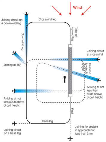
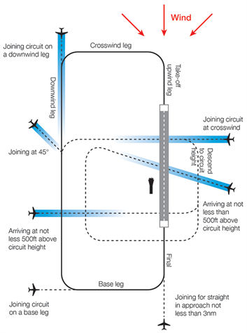
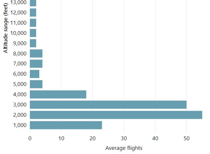
A training circuit consists of five legs – take-off, crosswind, downwind, base and final approach to the runway.

Aircraft take off into the wind, climb to 500 feet and then turn onto the crosswind leg. They continue to ascend to 1000 feet and turn onto the downwind leg. Having turned onto the base leg the descent commences. After turning onto the final leg and lining up with the runway the aircraft will touch down and take off again.

Helicopters circuit inside the fixed wing circuit at a lower altitude.

Aircraft usually conduct left hand circuits however at Cairns Airport, for noise abatement, when the runway is used in a northerly direction the aircraft will make a right turn so most of the circuit is over water.

A simplified representation of a left-hand circuit is shown at right. The take off and final stage of the circuit is flown into the wind, as this is the safest way for an aircraft to operate. The aircraft symbols and dotted lines indicate recommended ways for an aircraft to join the circuit pattern. Click the image to enlarge it, and use your browser “Back” button to return to this page.

Between 10.00 pm and 7.00 am, circuit training by jet aircraft (and other aircraft exceeding 5700 kilograms maximum take-off weight) is not permitted.

More information about circuit training is found here.

Flight tracks of scenic flights and circuit training is found in the Cairns Airport Flight Paths page.

How high are aircraft near me?

The altitudes of aircraft over your area can vary according to:

  • the airport the flight is coming from or going to
  • whether the aircraft is arriving, departing or in level flight
  • the specific requirements of the flight path
  • the need for air traffic control to maintain vertical separation between aircraft.

Find out more on our What are the rules about altitudes? page.