Noise Complaints and Information Service Report

We manage complaints and enquiries about aircraft noise and operations through our Noise Complaints and Information Service (NCIS). The information below is collected for the purpose of complaint management, analysis of issues and identification of causal factors.

For this reason we refer to ‘complainants’ and ‘issues’. Complainants are people who contacted us. While some people submitted enquiries or comments rather than complaints, all are referred to as “complainants”. Issues are the primary concern they raised.

The complaints report

Use this interactive tool to explore the issues raised by residents from different suburbs. For help, click the button in the bottom right-hand corner.

This report is best viewed in full screen mode.

Read an explanation of issues and classifications used in complaint reporting.


Investigation: Runway 16 departures over St Albans and Ardeer

Airservices explored the possibility of moving further south the point at which aircraft turn west after departure from Runway 16. After making this turn aircraft pass over St Albans. The investigation found that this was not feasible for two reasons. While it would result in benefits for Ardeer and St Albans, it would move the traffic and noise to Sunshine. In addition, aircraft would remain on the runway heading for longer and this would hamper efficient operations. The current procedure allows air traffic control to clear the next aircraft for take-off after the previous one has made the turn. If aircraft maintain the runway heading for longer, this means that more time must elapse before the aircraft behind can take off which would slow down the throughput of aircraft. The proposal was found to be unfeasible because it was not considered to be a noise improvement overall and for efficiency reasons.

Investigation: Runway 16 departures over Caroline Springs

The proposal was that an alternative flight path be designed off Runway 16 to utilise farm land and avoid Caroline Springs. Investigation found that this would increase noise impacts for St Albans and Sunshine North which are densely populated areas. Therefore more residents would be affected by this proposed change than would receive noise improvements. Airservices considers that noise improvements must be of benefit to the community as a whole and must clearly provide a reduction in overall noise impacts.

No opportunities were identified during this investigation that would provide an overall reduction in noise impacts. Caroline Springs is benefited at present by the Noise Abatement Procedures at Melbourne Airport which make Runway 16 departures the fourth preference.

Investigation: Runway 16 early turns

Following an increase in complaints about early turns of jet departures from Runway 16 during quarter 4 of 2013, Airservices contacted airlines about the problem. Airlines have reminded their pilots that aircraft taking off from Runway 16 for destinations to the north and east should only turn to the west once they have reached a waypoint four nautical miles (roughly seven kilometres) south of the airport. Airservices will continue to monitor this issue. Most subsequent instances of this have been found to be due to air traffic control instructions for traffic management reasons.

When is each flight path used?

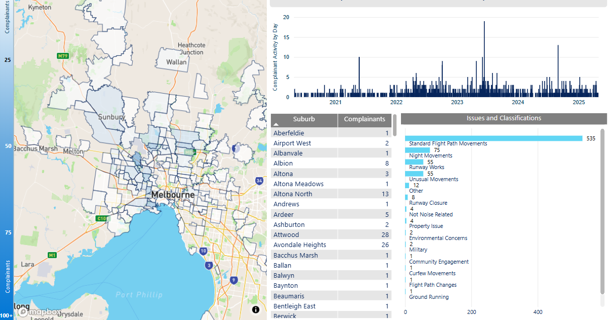
Flight paths in Melbourne are designed to accommodate, and keep segregated, aircraft arriving from and departing to ports in different directions. While there are some different flight paths for jets and non-jets there are other flight paths that are used by both types of aircraft. The vast majority of aircraft at Melbourne Airport are medium to large jets.

Arrivals

Jet arrivals into Melbourne are generally aligned with the runway at least ten kilometres from the airport. From this point they will fly towards the runway in a straight line. This means that suburbs in line with the runways are overflown by arriving jets. Other suburbs may be overflown by aircraft proceeding towards the point at which they join the final approach and align with the runway.

Runways 16 and 27 have Instrument Landing Systems. This type of approach requires aircraft to be aligned with the runway at a distance of around twenty kilometres and height above the elevation of the runway of around 3000 feet when they begin their approach. Aircraft will descend steadily to the runway using the horizontal and vertical guidance provided by the system. A similar instrument approach known as Honeywell SmartPath is available on all runways.

There is no minimum altitude for aircraft in the process of landing. Aircraft will generally descend on a glide slope of three degrees.

Departures

Departure flight paths allow aircraft to maintain the runway heading for a short time until they are stabilised in flight, and then to turn towards the route that will take them to their destination.

The altitude of aircraft after departure will depend on factors such as the type of aircraft and its weight, how heavily laden it is with fuel and passengers, and the atmospheric conditions at the time. All these factors affect an aircraft’s climb rate. There is no regulated minimum altitude for an aircraft in the process of taking off.

Smart Tracking

A growing number of modern aircraft are now fitted with navigation systems that use satellite-assisted guidance which allow aircraft to fly with a higher degree of accuracy and more closely follow the same route as other aircraft. Airservices refers to these routes as ‘Smart Tracking’. Smart Tracking technology makes air travel safer, cleaner and more dependable. It also has the potential to improve noise outcomes for communities living close to airports.

While there are standard flight paths, aircraft may be directed off these at times for reasons including the need to avoid bad weather or for traffic management, that is, to ensure safe separation between aircraft. See WebTrak for further information about where aircraft fly.

Investigation: Helicopter activities

Filming at the MCG

Airservices followed-up complaints about helicopters hovering over the Melbourne Cricket Ground (MCG) during sporting events. Helicopter operators advised the low winter sun often prevents filming from the south of the ground during the AFL season. Therefore on-ground advertising during the AFL season is orientated so that it is best viewed from the north, which is why helicopters tend to hover to the north of the ground (over residential areas).

The operators agreed to hover to the south whenever possible, and when filming from the north they will try as far as possible to hover over the park north of the MCG and not over residential areas. In addition, operators already try to use their quietest helicopters for operations over the MCG.

Traffic helicopters

Airservices contacted the traffic helicopter operator about these activities. The operator flies as high as possible to minimise noise to residents and has zoom lenses to enable filming from 1500 feet. The minimum altitude over residential areas is 1000 feet, although the operator has a dispensation from CASA to fly lower if required. This is rare. The helicopter has been fitted with mufflers to minimise noise to residents. Sometimes air traffic control require the helicopter to fly below 1500 feet or to hover to remain out of the way of regular aircraft traffic to and from Melbourne Airport. Otherwise, hovering is avoided whenever possible. In the morning, traffic reporting activities are usually finished by 9.00 am and in the evening by 6.00 pm.

Yarra River helipads

Following complaints from residents affected by helicopters operating to and from the Yarra River helipads, Airservices worked with helicopter operators to encourage them to minimise noise. Operators agreed, wherever possible, to use their quieter helicopters, to restrict the times they use the helipads and to try to avoid overflight of noise-sensitive areas.

The Yarra River helipads are outside controlled airspace. The are which the helipads occupy is under the control of Parks Victoria.

More information about helicopter operations

Will flights increase in the future in my area?

Flight Path and Airspace Changes

Visit Engage Airservices to engage with our program of flight path and airspace changes.

Airport Master Plans

Airport Master Plans provide a blueprint for the future development of an airport over a twenty year period. They include information on forecast growth, airport terminals and facilities, runways and flight paths.

Who is responsible for master planning?

Airports are responsible for producing the master plan.

Melbourne Airport

The Melbourne Airport Master Plan can be found on the Melbourne Airport website.

The Essendon Airport Master Plan can be found on the Essendon Airport Website.