Learn about flight paths and aircraft movements in your area
Welcome to the Aircraft in Your Neighborhood Portal
Our goal is that you will learn more about the flight paths and aircraft movements in your area and be able to access the information and resources that explain how air traffic is managed.
First, please select your location using one of the following options, so that we can customize the information for your location.
We’ll remember your location so you don’t have to enter it every time you visit the site and we’ll keep this information confidential.
Please note, that this site works best on Chrome, Firefox and Edge.
* Mandatory - Select region first to view the map.
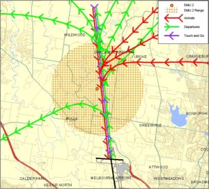
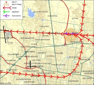
The illustration below shows how jet and non-jet (turbo-prop) aircraft typically operate at Melbourne Airport on the published instrument arrival and departure flight paths.
The animation is indicative only and provided for information purposes, on occasion flights may leave these general areas.
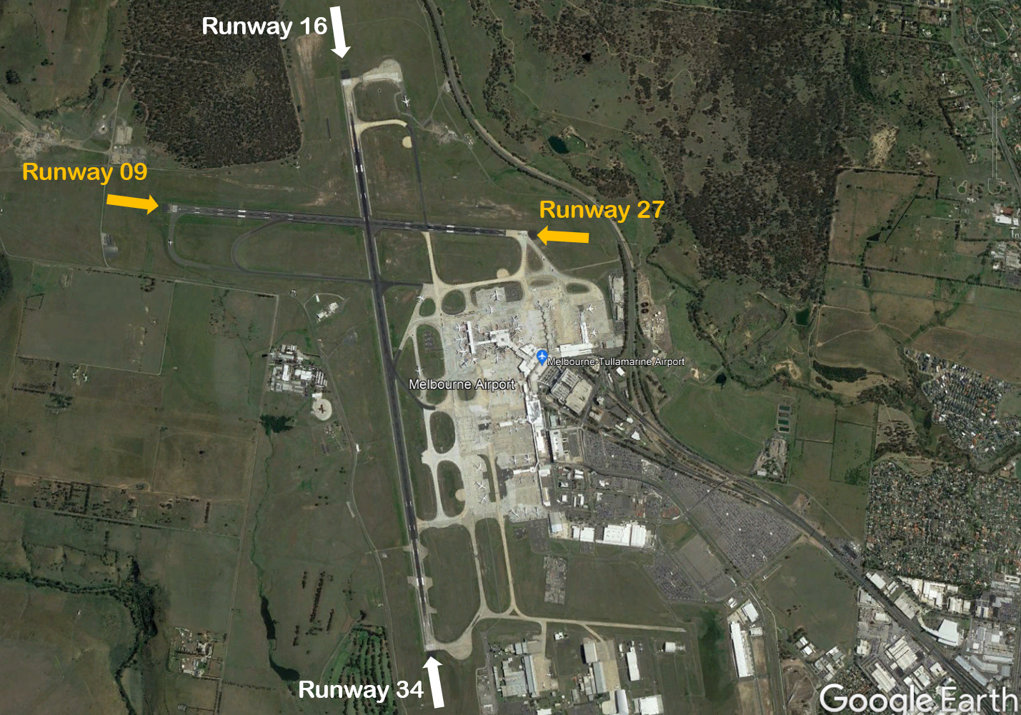
Melbourne Airport has two runways; the main runway, Runway 16/34 (3.7 km long) is orientated north-south and the smaller cross runway, Runway 09/27 (2.3km) is orientated east-west.
The main runway is known as Runway 34 when used in a northerly direction and Runway 16 when used in a southerly direction. Runway numbering reflects the runways’ orientation and correlates with degrees on a compass. Runway 34 is 340 degrees.
The following video explains how runways are named and used.
An Instrument Landing System operates for aircraft landing on Runways 16 and 27, and non-precision approaches are available to all runways.
Runway selection and seasonal winds
Runway selection is based on wind direction, weather conditions, traffic volume and other factors. Aircraft primarily take-off and land into the wind for safety and performance reasons. Therefore, as the wind direction changes the runway in operation may also change depending on the strength of the wind.
This means that Melbourne’s seasonal wind patterns affect usage of the different runway directions. Specifically, Runway 16 tends to be used more frequently in the warmer months due to southerly winds whereas Runway 34 tends to be used more frequently in the cooler months when the predominant wind direction tends to be northerly. The pattern of use of Runway 27 tends to be less clear-cut as it can generally be used with either a northerly or southerly wind, provided the crosswind does not exceed the maximum allowed speed of 20 knots, including gusts.
Runways may be used in combination. For example, Runway 27 may be used for departures while Runways 27 and 34 are being used in combination for arrivals.
Noise abatement procedures
Noise abatement procedures are designed to help reduce the impact of aircraft noise on communities. While they are applied whenever it is possible to do so, their use is not mandatory and is subject to weather conditions and traffic requirements. Apart from weather, other operational factors can also necessitate using a particular runway e.g. some large heavy aircraft and long haul flights require the length of the north-south runway to take off or land safely.
The Melbourne Airport Noise Abatement Procedures (NAP) prioritise landings and take-offs over less populated areas to the north and west of the airport whenever possible. The NAP distributes the use of flight paths via the nominated runways to lessen noise intensity over any single area.
The NAP outlines that between 6.00 am and 11.00 pm, when there is not heavy traffic, Runways 16 and 27 are equally preferred for landing. Runway 27 used in combination with Runway 34, and Runway 27 used alone, are equally preferred for departures.
During busy periods between 6.00 am and 11.00 pm, Runways 27 and 34 used in combination and Runways 34 and 09 used in combination are equally preferred.
At night, between 11.00 pm and 6.00 am, the preferred runway for arrivals is Runway 16 and for departures is Runway 27.
Melbourne Airport uses the high capacity landing mode, LAHSO (Land and Hold Short Operations) on Runway 34 during peak periods when wind conditions allow. It is used to increase airport capacity during peak arrival periods when significant airborne delays would otherwise occur. In this mode, aircraft land on runway 34 and exit the runway before the intersection with the east-west runway 09/27, so both runways can be used at the same time with minimal disruption. Pilots may accept a LAHSO clearance provided that the pilot-in-command is approved to use the procedure and has determined the aircraft can safely land and stop within the available landing distance.
When high arrivals demand requires the use of LAHSO, or when wind conditions mean that only one runway can be used due to strong crosswinds, the priority runways will change accordingly.
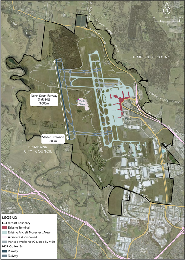
Melbourne Airport third runway
In September 2024, the federal government approved the Major Development Plan (MDP) for the construction of the third runway at Melbourne Airport.
Melbourne Airport conducted public exhibition of the MDP from February to May 2022, giving the community an opportunity to provide feedback and utilise an interactive noise tool to explore future aircraft tracks. The proposal included detailed planning documents and considered the project’s impact on the community.
The MDP approval is subject to certain conditions on Melbourne Airport including:
design and implementation of a Noise Sharing and Airspace Concept Plan that prioritises sharing of aircraft noise between affected areas
maintaining sufficient capacity on the existing east-west runway to support noise sharing
implementation of a noise amelioration program to communities most impacted
conducting a community health study into the impacts of noise before and after the establishment of the third runway
We expect that the operation of the third runway will result in aircraft noise decreasing in some areas and increasing in others. Further community engagement will be undertaken by both Airservices Australia and Melbourne Airport throughout the flight path design process.
For more information on the third runway and upcoming consultation opportunities, please visit the Melbourne Airport website.
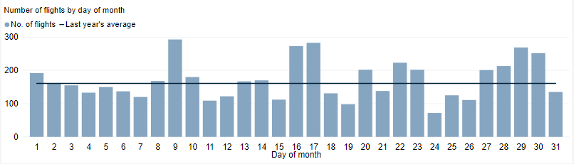
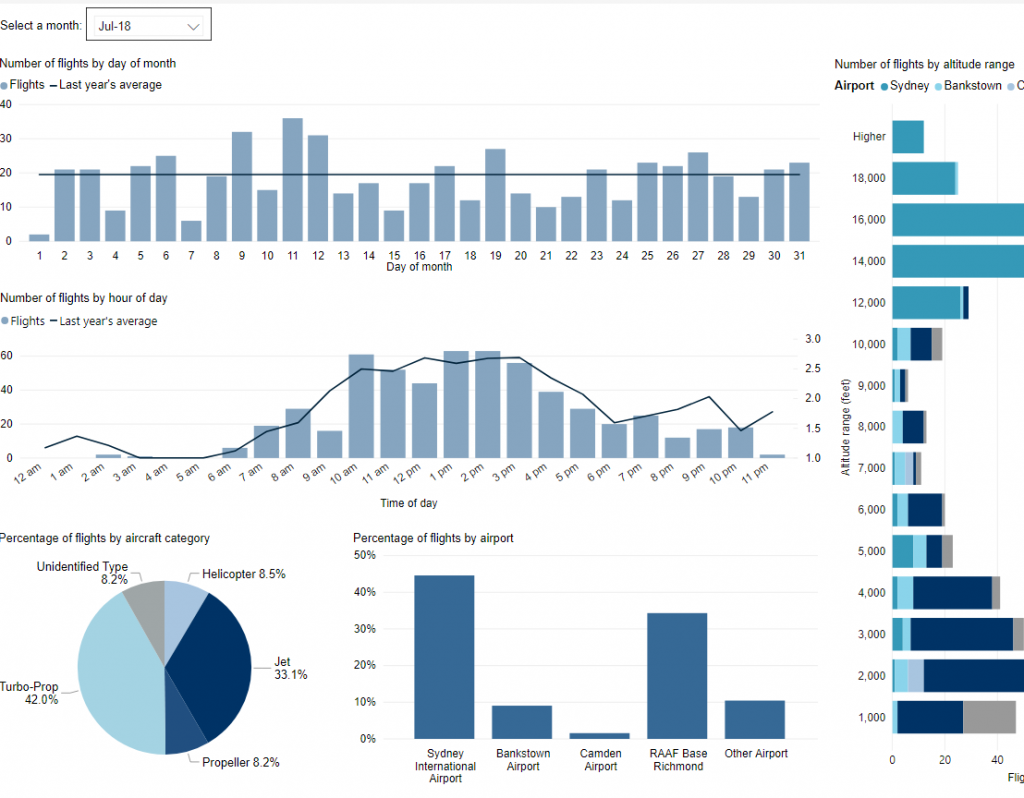
This tool shows the number of flights each day over your area in the selected month compared to the average for last year. The bottom axis shows the day of the month. Use the drop-down menu to change the selected month to see how movements have varied. Hover over each day to see flight numbers.
*Please note due to technical issues between 19 June and 22 June 2024, flight data may not be accurately displayed. Our supplier is working to resolve the issue. We apologise for any inconvenience this may cause.
There are a number of factors that influence the frequency of flights.
Firstly, the number and frequency of flights will vary on a daily, weekly and yearly basis due to differences in airline schedules. The airlines schedule flights in response to consumer demand. This is particularly the case around Christmas, Easter, school holidays and Lunar New Year.
Secondly, the runway in use at any given time will also vary, largely due to the wind conditions. Each runway has its own set of flight paths, and each flight path will affect different areas. As the runway in use changes, the flight paths change, and so too do the areas affected by aircraft movements.
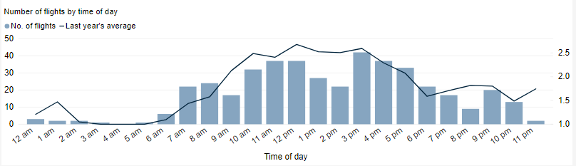
This chart shows the total number of flights each hour over the month, compared to the average for last year. Change the selected month to see how it has varied.
*Please note due to technical issues between 19 June and 22 June 2024, flight data may not be accurately displayed. Our supplier is working to resolve the issue. We apologise for any inconvenience this may cause.
*Please note due to technical issues between 19 June and 22 June 2024, flight data may not be accurately displayed. Our supplier is working to resolve the issue. We apologise for any inconvenience this may cause.
Federally-leased airports (excluding Mt. Isa and Tennant Creek) have established Community Aviation Consultation Groups (CACGs), which provide an effective avenue for local community engagement on airport planning and operations, including aircraft noise. The Department for Infrastructure, Transport, Regional Development and Communications provides guidelines for CACGs.
Non federally-leased airports may also choose to establish CACGs or community forums.
CACG membership depends on the characteristics of the airport and any local issues of community concern however, generally includes:
airport management
aircraft operators
community organisations or representatives
representatives from state, territory or local government bodies
local tourism and business groups.
Airservices does not formally belong to CACGs, but is invited to attend to provide relevant information and assist in discussions. We engage with CACGs on flight path and airspace changes, as well as technical reviews, such as noise monitoring and noise abatement procedures.
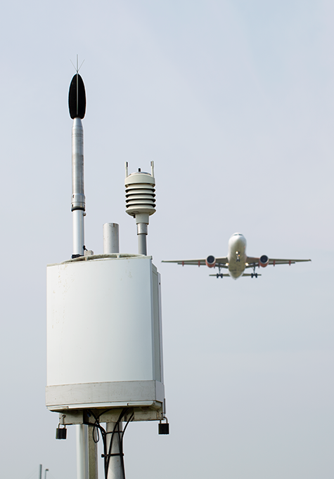
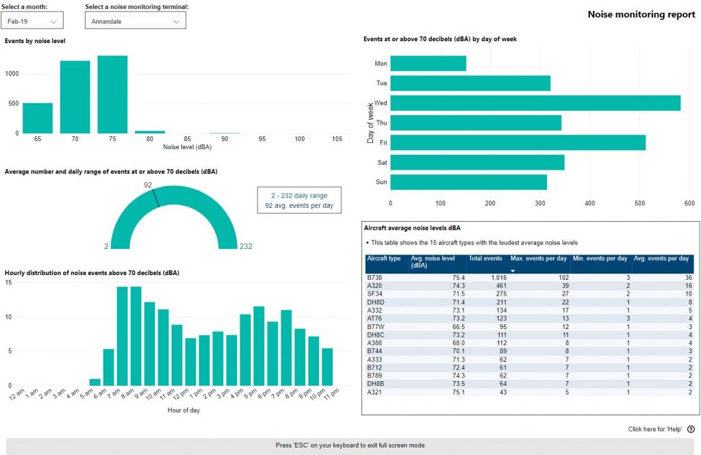
We collect noise and operational data from five noise monitors (Environmental Monitoring Unit, EMU) around Melbourne Airport. Noise monitors are listed below according to their location.
Captures arrivals to Melbourne Runway 16 and departures from Melbourne Runway 34.
Detects more events than the other noise monitor locations due to its proximity to the airport. The pattern of aircraft noise events recorded reflects the seasonal trends in arrivals to Runway 16, with more events recorded in summer than in winter.
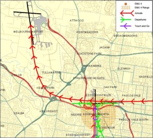
ESSENDON (EMU 4)
Captures arrivals to Melbourne Runway 34 and arrivals to Essendon Runway 35 and departures off Essendon Runway 17.
Seasonal fluctuations in the use of Runway 34 at Melbourne Airport are offset by the opposite fluctuations in the use of Runway 17 at Essendon Airport.
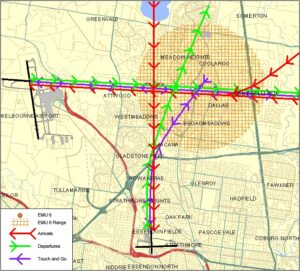
COOLAROO (EMU 6)
Captures arrivals to Melbourne Runway 27.
While the pattern of noise events recorded reflects the seasonal trend for arrivals to Runway 27 the correlation is not precise as there are some parts of the year where for noise abatement purposes, Runway 27 is used more for departures than for arrivals. Departures from Runway 27 do not fly over this monitor.
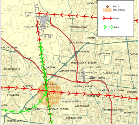
KEILOR DOWNS (EMU 9)
Captures arrivals to Melbourne Runway 34 and Melbourne Runway 27 and departures off Melbourne Runway 16.
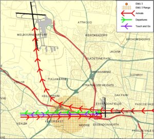
KEILOR EAST (EMU 3)
Captures arrivals to Melbourne Runway 34 and arrivals to Essendon Runway 08 and departure off Essendon Runway 26.
The pattern of aircraft noise events reflects the seasonal trend for arrivals to Runway 34, with more events recorded in winter than in summer.
THOMASTOWN (EMU 11)
Captures arrivals to Melbourne Runway 27.
The pattern of aircraft noise events recorded reflects the seasonal trend for arrivals to Runway 27, with more events recorded in winter than in summer. As a result the trend for this monitor mirrors that of Coolaroo monitor.
Use this interactive tool to explore detailed data for your area in the month of your choice.
This report is best viewed in full screen mode.
*Please note due to technical issues between 19 June and 22 June 2024, flight data may not be accurately displayed. Our supplier is working to resolve the issue. We apologise for any inconvenience this may cause.
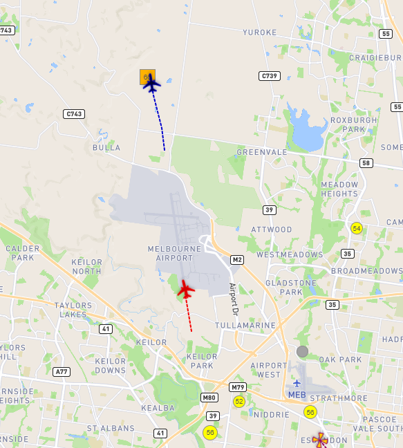
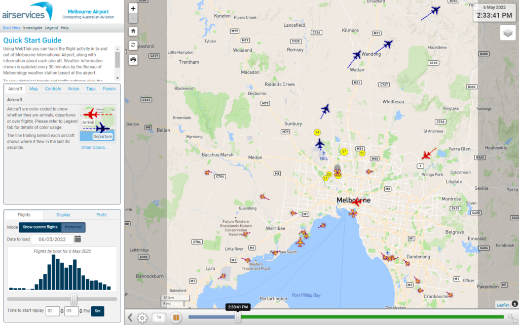
WebTrak is a tool that enables the community to see where aircraft fly and explore historical trends and patterns. WebTrak is provided by Envirosuite.
WebTrak uses information from air traffic control radars to display aircraft movements. The flight search and display function allows you to view aircraft flight activity over metropolitan areas. You can also:
locate your street address and have your home appear on the map
see noise levels of individual aircraft
view information about aircraft type, height, origin and destination
display an aircraft’s flight path and point of closest approach to your home
zoom in and out down to street level.
Note that there is a slight delay on the display of flights.