Learn about flight paths and aircraft movements in your area
Welcome to the Aircraft in Your Neighborhood Portal
Our goal is that you will learn more about the flight paths and aircraft movements in your area and be able to access the information and resources that explain how air traffic is managed.
First, please select your location using one of the following options, so that we can customize the information for your location.
We’ll remember your location so you don’t have to enter it every time you visit the site and we’ll keep this information confidential.
Please note, that this site works best on Chrome, Firefox and Edge.
* Mandatory - Select region first to view the map.
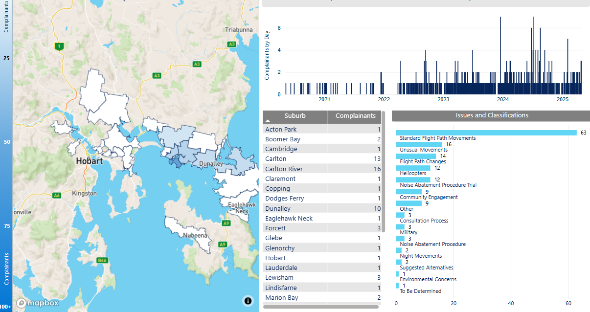
We manage complaints and enquiries about aircraft noise and operations through our Noise Complaints and Information Service (NCIS). The information below is collected for the purpose of complaint management, analysis of issues and identification of causal factors.
For this reason we refer to ‘complainants’ and ‘issues’. Complainants are people who contacted us. While some people submitted enquiries or comments rather than complaints, all are referred to as “complainants”. Issues are the primary concern they raised.
The complaints report
Use this interactive tool to explore the issues raised by residents from different suburbs. For help, click the button in the bottom right-hand corner.
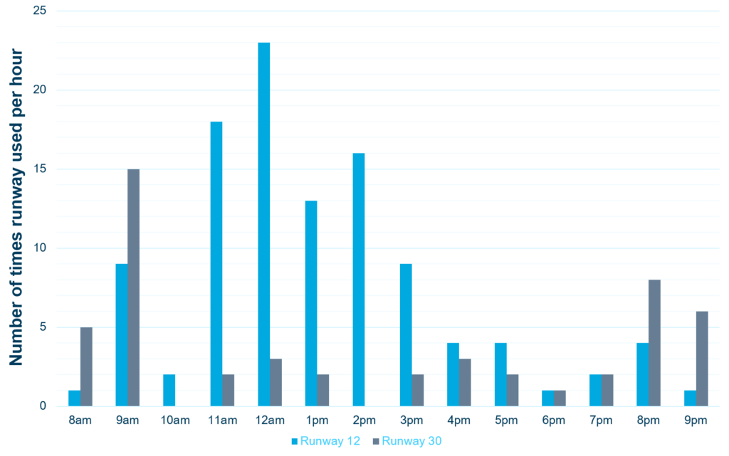
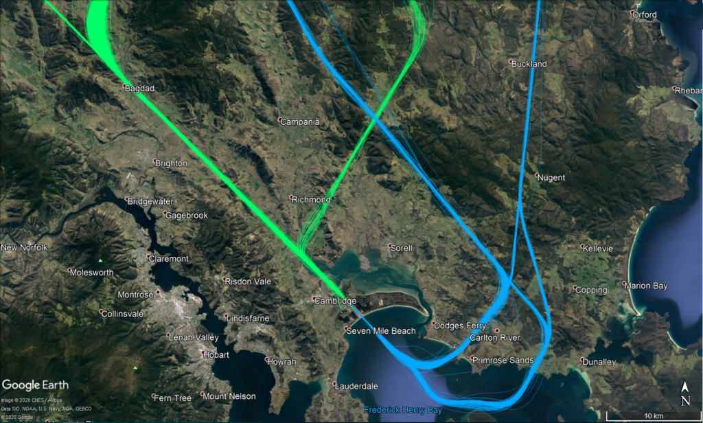
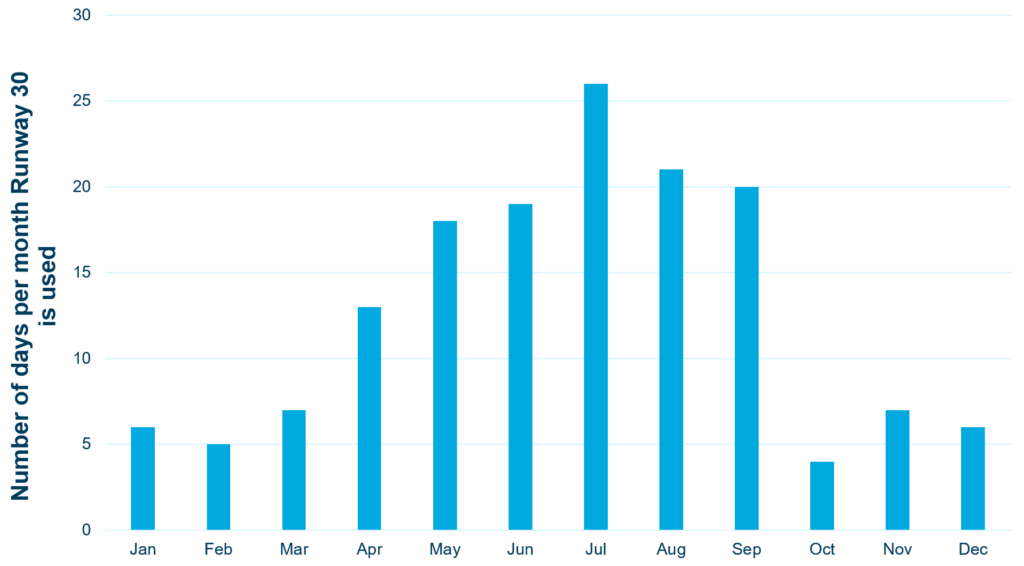
Aircraft usually take-off and land into the wind for safety and performance reasons. As the wind direction changes, the runway in operation and the flight paths being used may also change.
This means that Hobart’s seasonal wind patterns affect usage of the different runway directions.
Summer
During summer, when afternoon sea-breezes are common, the wind varies so both Runway 12 and Runway 30 are used.
Runway 30 is mostly used in the morning (8-9am) and evening (8-9pm) and Runway 12 is mostly used during the day (10am-5pm).
The flight paths in use change depending on the runway being used.
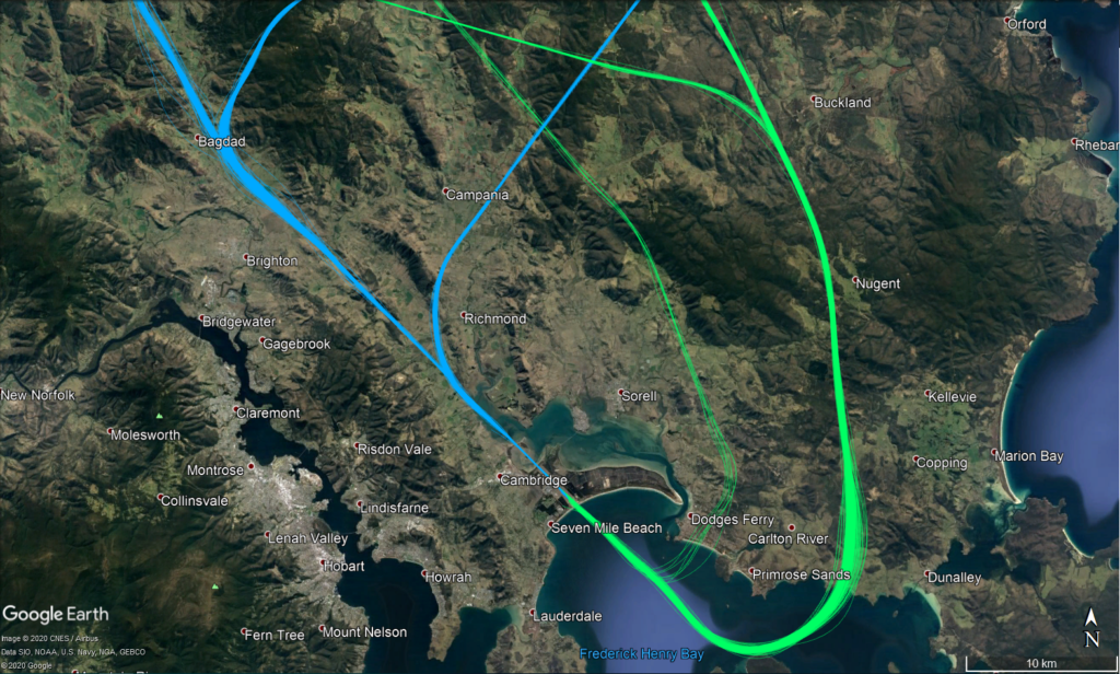
When Runway 12 is used, aircraft depart to the south before turning north and crossing the coast near Connellys Marsh (jets) or Dodges Ferry/Carlton (non-jets). Aircraft arrive from the north using two approach paths (depending on the technology available on-board the aircraft) near Campania or Bagdad.
When Runway 30 is used, aircraft depart to the north before turning near Bagdad (jets) or Richmond (non-jets). Aircraft arrive from the south using two approach paths (depending on the technology available on-board the aircraft), crossing the coast near Carlton/Primrose Sands or Connellys Marsh.
Most of the year
The prevailing wind is north-westerly for most of the year (approximately 75% of the year), meaning that Runway 30 is used most frequently.
The flight paths in use are most often those for Runway 30.
When Runway 30 is used, aircraft depart to the north before turning near Bagdad (jets) or Richmond (non-jets). Aircraft arrive from the south using two approach paths (depending on the technology available on-board the aircraft), crossing the coast near Carlton/Primrose Sands or Connellys Marsh.
Note: All tracks have been displayed. Track colours have been adjusted to show track density. Where aircraft are more concentrated the colour will appear darker.