When is each flight path used?

Each runway in use at an airport has its own set of flight paths, and each flight path will affect different areas. As the runway in use changes, the flight paths in use will change, and so too do the suburbs affected by aircraft movements.

The runway in use at any given time and the direction of the traffic flow will vary primarily according to the wind conditions at the airport. This is because aircraft must take off and land into the wind for safety reasons. Generally, this means that in:

  • Northerly wind conditions at the airport (including north-westerlies and north-easterlies), north flow will be used.
  • Southerly wind conditions at the airport, including south-westerly and south-easterly conditions, south flow will be used.

However at times a runway direction may be used with a small amount of tailwind as long as it does not exceed the Civil Aviation Safety Authority’s limits for downwind (tailwind) and crosswind.

When the wind at the airport is calm or light, other factors are taken into account in selecting the runway that will be used. For example, the location of the terminals and the positioning of the taxiways can influence the decision.

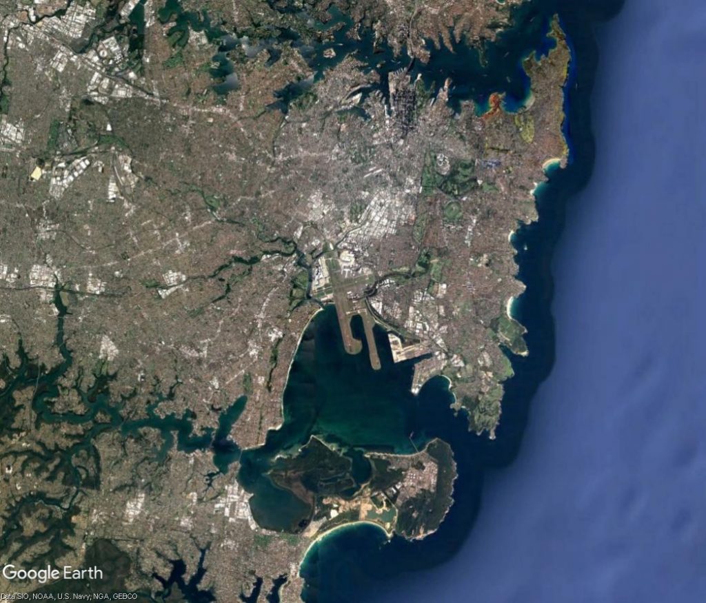
At Sydney Airport, the proximity of the terminals to the northern end of the westernmost parallel runway means that in busy periods when south flow is being used, there is not always enough space on the taxiways between the terminals and the runway end for all the waiting aircraft to queue for take-off.

To manage this, some aircraft may need to be held at the departure gate until space becomes available. This can result in delays and create knock-on effects around the country. For this reason, if the wind is not a factor in the decision, north flow will usually be preferred over south flow during peak periods.
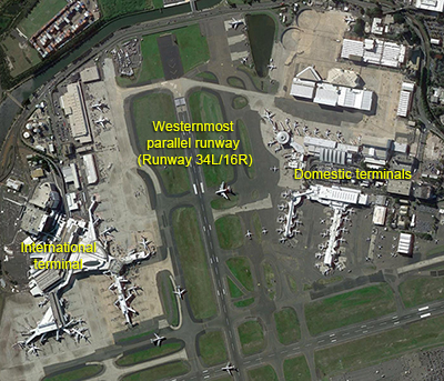
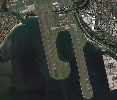
Location of terminals at Sydney Airport
Southern end

The proximity of the terminals to the runway at northern end of Sydney Airport means there is limited space on the taxiways for queuing. Below right: There is much more room for queuing aircraft on the taxiways at the southern end of the Airport.

Our page on Runway Selection discusses how decisions are made about which runway to use.

Bankstown Airport flight paths

Bankstown Airport was established in the 1940s and is a general aviation airport primarily used by general aviation aircraft.

The airport is a base for the NSW Police Air Wing, the NSW National Parks and Wildlife Service, the Royal Flying Doctor Service, NSW Forests, Greater Sydney Area Helicopter Medical Service, and the Aviation Studies program of the University of NSW. During the summer months large firefighting helicopters are also based at Bankstown Airport.

Bankstown Airport operates 24 hours a day but noise abatement procedures apply.

Flight paths

The majority of aircraft using Bankstown Airport fly on designated routes to ensure separation with other air traffic, including aircraft operating to and from Sydney Airport.

These routes are outside controlled airspace which means that aircraft using them are not being directed by air traffic control. When flying outside of controller airspace pilots are following the rules of the air. Our booklet, Guide to our Operations, explains more about different types of airspace.

The transition between uncontrolled and controlled airspace, such as the are around Bankstown airport, must happen at defined points to maintain safety. These points are often located at local landmarks so they are easily recognized by pilots from the air.

When operating around Bankstown airport it is important to note that:

  • For arriving and landing aircraft there is no minimum altitude limit although aircraft will typically descent to the airport on a glide slope.
  • For departing aircraft, there is no also no minimum altitude limit and the rate of climb will vary depending on a number of factors including the type of aircraft and its weight, how heavily laden it is with fuel and passengers, and the atmospheric conditions at the time.

The following image displays the typical flight paths into and out of Bankstown.

Sydney Airport – Traffic management of arrivals from the north

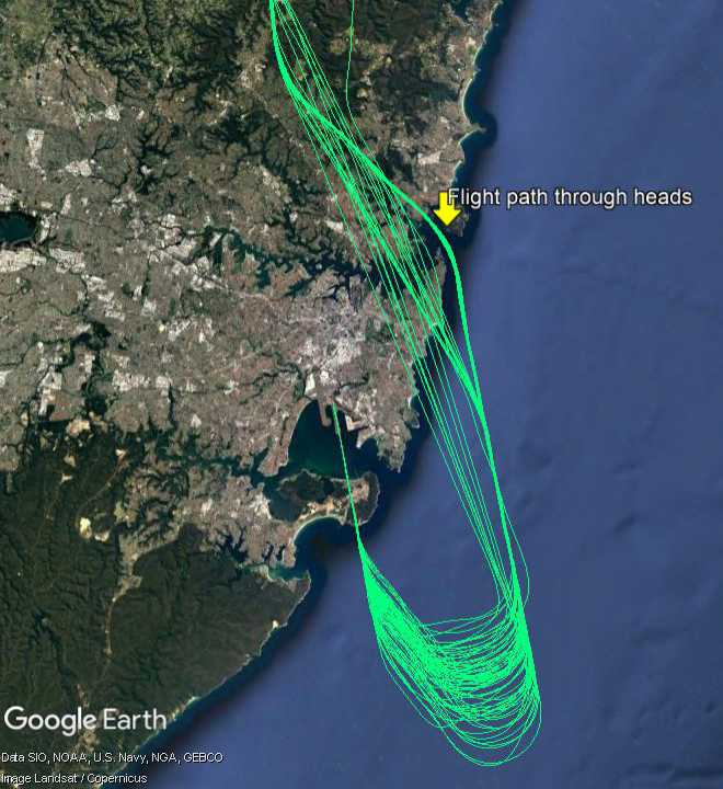
There is a flight path for aircraft arriving into Sydney from northern ports that brings aircraft through the Sydney heads and southwards down the coast, over water, to arrive on the easternmost parallel runway. This flight path is used when the parallel runways are being used in a northerly direction (“north flow”).

There are times when air traffic controllers need to take aircraft off this flight path to ensure they remain safely separated from other traffic and/or can be efficiently sequenced with aircraft arriving from the east, south and west for landing. When there is poor weather, or in peak periods when there is a high volume of traffic in the airspace, this is more likely to occur.

The image at right shows actual tracks of aircraft arriving into Sydney from the north and travelling southwards to land on the easternmost parallel runway.

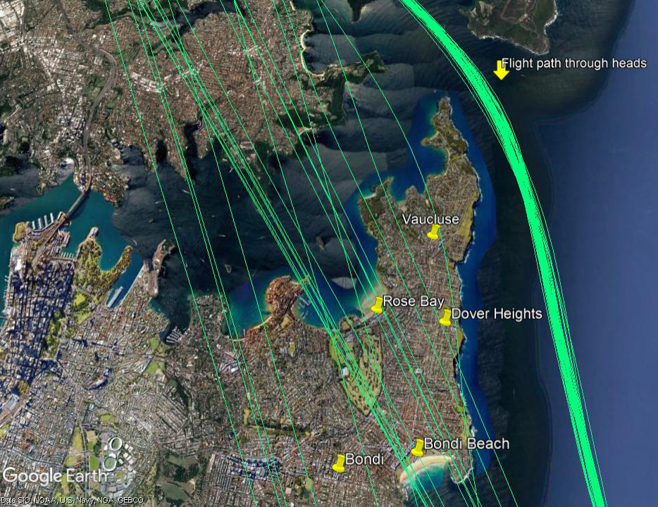
When aircraft are diverted from the usual flight path they must be directed over land, and will pass over suburbs such as Rose Bay, Dover Heights and Point Piper. It is not possible to divert these aircraft further east, over the water, because this would create potential conflicts with aircraft that are departing from the easternmost parallel runway and heading north-east. The conflicts could occur because the departures and the arrivals would be at similar altitudes when their paths crossed.

The image below is a zoomed in view of the tracks of aircraft arriving from the north. Aircraft on the usual flight path can be seen flying through the heads and down the coast over water. Aircraft that have been taken off the normal flight path can be seen flying over land.

Traffic management - arrivals from the north

Aircraft taken off the usual flight path will generally be in the altitude range of 6,000 to 8,000 feet as they pass over the eastern suburbs. This is around twice as high as the jet aircraft that depart over the area.

Air traffic controllers are aware of potential noise implications for the community and do not take aircraft off standard routes unless it is operationally necessary. Unfortunately, when operationally required, this cannot be avoided.

Sydney Airport – Blue Mountains

Aircraft that fly over the Blue Mountains from Sydney Airport depart from the westernmost of the parallel runways and turn towards the north-west. They are tracking towards a waypoint located over Katoomba. A waypoint is a set of co-ordinates in the air. This waypoint replaces a non-directional beacon which was a ground-based navigational aid that had been in this location since the 1950s.

Departure flight paths are organised so as to efficiently move aircraft onto their routes. The flight path that passes over the Blue Mountains is assigned to aircraft that are heading for destinations to the west, north and north-west such as Dubbo, Perth, Adelaide, Darwin, Broome, Singapore, Kuala Lumpur, Dubai, Abu Dhabi, Hong Kong and Shanghai, for example.

While this is not a new flight path, advances in navigation technology used by modern aircraft mean that aircraft are now able to fly flight paths more precisely and this has resulted in increased concentration of flight paths over the years, including this one.

Altitudes

The altitudes of traffic departing Sydney Airport will vary according to which runway the aircraft has departed from because this affects the number of track miles the aircraft has flown before it reaches the Blue Mountains. The more track miles flown, the more time the aircraft has had to increase altitude and the higher it will be over your area.

Altitudes will also vary according to other factors such as the weight of the aircraft and how heavily laden it is. For example, long-haul aircraft departing for Dubai will be much heavier than smaller aircraft heading to Perth or Adelaide due to fuel load and aircraft size and these differences in weight alone will affect an aircraft’s climb rate.

Even the atmospheric conditions at the time can play a part. When the weather is warm, the air is less dense and therefore there is less lift and the aircraft climbs more slowly. Due to these variable factors the altitudes quoted below are not limits and some aircraft may be higher and some lower that the ranges given.

Jet aircraft departing towards the north will generally be within the altitude range of 10,000 to 20,000 feet. Turbo-prop aircraft that have departed Sydney Airport may range from 7,000 to 15,000 feet.

For aircraft departing towards the south, jets will generally be from 15,000 to 25,000 feet. Turbo-prop aircraft will usually be from 10,000 to 15,000 feet.

Many Blue Mountains residents have told us they feel jet aircraft are lower now than in the past. We conducted an investigation into this question, looking at altitudes of aircraft that passed within a five kilometre radius of Blaxland in January of each year from 2012 to 2018. The investigation found variation in altitudes between different aircraft types but relatively little variation within the same aircraft type. The variation in altitudes between aircraft types can be attributed largely to the differing maximum take-off weight of each type. Heavier jets demonstrated a poorer climb performance than lighter jets.

The investigation also found a marked increase in airlines using A380-800 aircraft – from 23 flights in January 2012 to 126 flights in January 2018. As the A380 is the heaviest jet and as the study indicated that they have the lowest average altitude, the increased use of this aircraft type is likely to be a major contributing factor to the community’s perception that altitudes over Blaxland have decreased.

Prospects for change

Airservices has investigated whether it would be feasible to move the Katoomba waypoint. The investigation found that this would adversely impact on safety and would not be operationally feasible due to the constraints of military airspace restrictions and air traffic control sector boundary and route segregation requirements. It would also negatively impact on communities closer to Sydney Airport where the noise levels would be higher than those currently experienced in the Blue Mountains.

RAAF Base Richmond

A large expanse of military airspace exists around Richmond RAAF Base in the north-west of Sydney, as shown in the image below. Locations inside and surrounding this area are likely to experience noise from military aircraft operations. This includes activities within the restricted area and aircraft flying in and out of the Base to and from other destinations.

Military airspace

Noise Mitigation

The Department of Defence Aircraft Noise Management Strategy outlines how they work with local communities to reduce noise impacts, while balancing operational and training requirements.

Flying operations are conducted in consideration of local communities, whilst maintaining the safe operation of the aircraft. More information can be found in the:

You can access more information on military aircraft activity at:

How frequent are flights in my area?

There are a number of factors that influence the frequency of flights.

Firstly, the number and frequency of flights will vary on a daily, weekly and yearly basis due to differences in airline schedules. The airlines schedule flights in response to consumer demand. This is particularly the case around Christmas, Easter, school holidays and Lunar New Year.

Secondly, the runway in use at any given time will also vary, largely due to the wind conditions. Each runway has its own set of flight paths, and each flight path will affect different areas. As the runway in use changes, the flight paths change, and so too do the areas affected by aircraft movements.

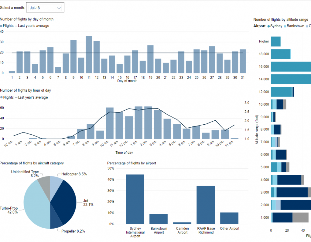
This chart shows the total number of flights each hour over the month, compared to the average for last year. Change the selected month to see how it has varied.

*Please note due to technical issues between 19 June and 22 June 2024, flight data may not be accurately displayed. Our supplier is working to resolve the issue. We apologise for any inconvenience this may cause.

How high are aircraft near me?

The altitudes of aircraft over your area can vary according to:

  • the airport the flight is coming from or going to
  • whether the aircraft is arriving, departing or in level flight
  • the specific requirements of the flight path
  • the need for air traffic control to maintain vertical separation between aircraft.

Find out more on our What are the rules about altitudes? page.

*Please note due to technical issues between 19 June and 22 June 2024, flight data may not be accurately displayed. Our supplier is working to resolve the issue. We apologise for any inconvenience this may cause.

Explore detailed data for your area

Use this interactive tool to explore detailed data for your suburb in the month of your choice.

This report is best viewed in full screen mode.

*Please note due to technical issues between 19 June and 22 June 2024, flight data may not be accurately displayed. Our supplier is working to resolve the issue. We apologise for any inconvenience this may cause.

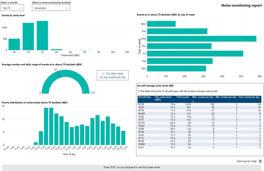
Sydney noise monitoring report

Use this interactive tool to explore monthly noise monitoring data.

This report is best viewed in full screen mode.

To learn more about noise monitor terminal locations visit our Sydney Noise and Flight Path Monitoring System page.

Why does the amount of light aircraft and helicopter traffic vary?

The amount of light aircraft and helicopters flying at any given time will vary.

Weather

Helicopters and light aircraft often fly Visual Flight Rules (VFR) where the pilot uses visual references to the ground or water and does not fly on a set flight path. This means that when the weather is poor, for example when low cloud or fog hampers visibility, these aircraft cannot fly and you will notice a significant drop in the amount of this type of traffic.

Weekends and holidays

Pilots who fly solely for their own recreation generally have weekday jobs and therefore will fly on weekends and holidays when the weather is good. This can contribute to an increase in light aircraft traffic on weekends and some holiday periods.

Time of day

As most recreational pilots are not licenced to fly at night, recreational traffic generally ceases at sunset.

Flying courses

Flying courses have a number of different stages in which students cover theory, then begin circuit training and then progress to flying to training areas and other locations with their instructor. Some courses include night flying training. As students progress through these different stages you may notice variation in the frequency and/or location of light aircraft and helicopter traffic. During periods in-between courses, or during holiday breaks within courses, you may notice a drop in traffic.