Perth Airport NAP 2: Preferred Flight Paths
The NAP lists the preferred flight paths as:
2.1 Minimum Height Over Residential Areas
- Turbo-prop aircraft – minimum altitude of 3,000 ft AGL.
- Jet aircraft – minimum altitude of 5,000 ft AGL.
Note: This NAP is under review to determine how it can be reported
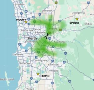
2.2 Departures to the east of Perth
- Aircraft departing to the east of Perth on SIDs will be kept on track until leaving an altitude of 8,000ft except when required for operational reasons
Adherence with this procedure is reported below (combined with 2.3).
2.3 Departures
- Air traffic control (ATC) shall normally process departing aircraft using standard departure paths (SIDs)
- When not following a procedural SID, use flight paths that approximate the SID tracks where possible
Note:
Adherence with this procedure is reported below (combined with 2.2). SID operations are reported up to 10,000ft adherence.
Note: A procedural SID is a published route aircraft use to safely travel through the busy airspace surrounding airports. Aircraft follow this route from departure to where they transition to the enroute (high-level airspace) phase of their flight. Procedural SIDs act like a road, providing an established path for aircraft to track along. They make separation from other aircraft easier and air traffic control more predictable.
2.4 Arrivals
- Arriving aircraft must be processed via standard arrival paths (STARs) where available
- Only deviate from STAR path if essential for sequencing arrivals or separation with other aircraft
Adherence with this procedure is reported below.
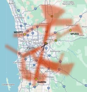
2.5 Non-STAR Tracking
Non-STAR tracking must approximate STAR tracks or comply with minimum height requirements, with specific exceptions for each landing runway direction (e.g. visual approaches where pilots navigate by visual landmarks instead of procedures, and other exceptions based on the direction of arrival). These exceptions are:
- Landing runway 21, arriving from the south
- Aircraft at or below 45000kg maximum take-off weight can fly visually using a left turn to join final approach
- Landing runway 21, arriving from the west
- via waypoint WOOFY to 6 nautical miles from Runway 21 for a visual approach
- Landing runway 24, arriving from the south
- via waypoint SPUDO
- Landing runway 03, arriving from the south or west
- via waypoint HARMN for an Instrument Landing System (ILS) approach
- track to 5 nautical miles from Runway 03 for visual approach
- Landing runway 06, arriving from the southwest or west
- track west of the coast to conduct a straight in approach
Waypoints – A waypoint is a geographical location used to define a point on a flight path. Waypoints are defined by geographic coordinates and typically take the form of a five-letter capitalised word e.g. WOOFY, SPUDO, HARMN.
Standard Instrument Departures (SID) and Standard Instrument Arrivals (STARs) are published flight paths designed to enhance safety, efficiency, and predictability. Air traffic control (ATC) may issue a deviation to a SID or STAR due to weather and/ or traffic conditions.
The report is best viewed in full screen mode.
Note: Due to rounding, percentage values may not sum to exactly 100.0%. Minor discrepancies of up to ±1% are expected and do not indicate any errors in the underlying absolute figures, which remain accurate and unaffected.
